Wikimedi'Òc
Modes d'emploi

Cet album fait partie des albums
Cet album photos contient les sous-albums suivants :


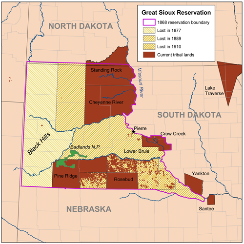
Siouxreservationmap.png - Kmusser

The La Vérendrye brothers. Historical marker at Fort Pierre, South Dakota.jpg - Naawada2016

Bozeman Trail, the forts and the Indian territories.jpg - Naawada2016

The Fetterman Fight. Map showing the battle ground and the Indian territories.jpg - Naawada2016

The Crow Indian reservation and some battlefields (c.).jpg - Naawada2016

Lakota 1851 treaty territory. (Area 408, 516, 584, 597, 598 and 632).png - Naawada2016

Treaty of Fort Laramie (1851). Map (circa).png - Naawada2016
Battiste Good's winter count (Lakota). 1843-44. The return of a sacred arrow of the Cheyenne.png - Naawada2016

Cloud-Shield's winter count (Lakota). 1873-74. Massacre Canyon battle, Nebraska.png - Naawada2016

American Horse winter count, 1820-1821. Crow camp attacked.jpg - Naawada2016

The outline of the 1851 Sioux territory. Crow 1851 territory (yellow 517, grey 619 and pink 635).jpg - Naawada2016

Fort Laramie Treaty (1851). Definition of Crow territory west of Powder River enlarged.jpg - Naawada2016

De Smet map of the 1851 Fort Laramie Indian territories (the light area). PNG.png - Naawada2016

Indian Sign left by the Dakotas on their Trail.jpg - Naawada2016

Indian Sign left by the Dakotas on their Trail (cropped).jpg - GreenMeansGo