Wikimedi'Òc
Modes d'emploi

Cet album fait partie des albums
Cet album photos contient les sous-albums suivants :


Schedel weltkarte.jpg - Rettinghaus

Samuel de Champlain Carte geographique de la Nouvelle France.jpg - Fern 24

Moll - The north part of Great Britain called Scotland.png - Frank Schulenburg
Willem Blaeu - Tabula Magellanica 1635.jpg - Jan Arkesteijn

Asia Map 1689.JPG - Tarawneh
L'Asie divisée en tous ses Etats 2.jpg - Jonathan Groß

1644 Europa Recens Blaeu.jpg - Jan Arkesteijn

1660 Oost Indien Goos'.jpg - Joopr

Detail (south) ebstorf world map.jpg - Ziko

Gulf1..JPG - File Upload Bot (Magnus Manske)

Frankfurt am Main - Novam Hanc Territorii Francofurtensis Tabulam (J.Blaeu, 1663).jpg - Kweniston

Cellarius Harmonia Macrocosmica - Hemisphaerii Borealis Coeli et Terrae Sphaerica Scenographia.jpg - Micheletb

MapEastIndian-PieterGoos.jpg - Pmaas

Mappemonde 1683.JPG - Thesupermat

Psalter World Map, c.1265.jpg - Mturtle

Heptarchy - John Speed.jpg - Joopr132

Grazioso Benincasa. Biblioteca Universitaria, Bolonia.1482.jpg - Geagea

1775 Lotter Map of the World on a Hemisphere Projection - Geographicus - TotiusMundi-lotter-1775.jpg - BotMultichill

1850 Tallis Map of East Canada or Quebec and New Brunswick - Geographicus - EastCanada-tallis-1850.jpg - BotMultichill

1852 Levasseur Map of Asia - Geographicus - Asia-levasseur-1852.jpg - BotMultichillT

1707 Homann and Doppelmayr Map of the Moon - Geographicus - TabulaSelenographicaMoon-doppelmayr-1707.jpg - BotMultichillT

1744 Bowen Map of the World in Hemispheres - Geographicus - World-bowen-1744.jpg - LlywelynII

Atlas maior 1655 - vol 10 - Novus Atlas Sinensis - China - P1080382.JPG - Vmenkov

Cometa qui anno Christi 1742 apparuit ex observationibus a die 13 Marty usque ad 15 Aprilis by Matthäus Seutter.jpg - Holger.Ellgaard

Geographia universalis by Sebastian Munster.jpg - Tomer T

4' 1608 Com Hollandia Blaeu HR.jpg - Joop Rotte

1621 Americæ Blaeu.jpg - Joop Rotte
Map of Bohemia (part) by Johann Georg Vogt (alias Mauritius Vogt) 1712.tiff - Tulinekmulinek

Afrique (Ancien Continent) - Fonds Ancely - B315556101 A LEVASSEUR 097.jpg - AncelyBot

Europ, and the cheife cities contayned therin, described; with the habits of most kingdoms now in use (8643121544).jpg - File Upload Bot (Magnus Manske)

A new, plaine, and exact map of Asia described by N.I. Visscher, and done into English, enlarged, and corrected, according to I. Blaeu, with the habits of ye countries, and manner of the cheife citties, ye like never before (4231923980).jpg - File Upload Bot (Magnus Manske)

Americae tam septentrionalis quam meridionalis in mappa geographica delineatio (4071871047).jpg - File Upload Bot (Magnus Manske)

A new map of the terraqueous globe according to the ancient discoveries and most general divisions of it into continents and oceans (4072622916).jpg - File Upload Bot (Magnus Manske)

A new map of the terraqueous globe according to the latest discoveries and most general divisions of it into continents and oceans (4071859313).jpg - File Upload Bot (Magnus Manske)

Doppelmayr's "Hemisphaerium Coeli Australe...", c 1730.jpg - BenEsq

Asia, 1658 (plaine, and map described by N.I. Visscher).jpg - Jambnoun

Antique World Map of Continents and Oceans 1700.png - Mattes

Schedelsche Weltchronik — Secunda etas mundi — Folio 12v 13r.jpg - Mattes

Schedelsche Weltchronik — Secunda etas mundi — Folio 12v.jpg - Mattes

Das Reich der Liebe Zweyter Landchartensatz-Versuch.gif - Mattes

World map from Japan, Bankoku sozu, 1671.jpg - LlywelynII
AGAD Guilielmo Blaeuw Europa.png - Happa
Finnmark - no-nb krt 00728.jpg - Lomita

Atlas Ortelius KB PPN369376781-085av-085br.jpg - HuskyBot
Karta över Asien av Frederick de Wit (1616-1698) - Skoklosters slott - 93667.tif - LSHuploadBot

Carte du royaume de France divisé en 87 départements - 1814.jpg - Rexcornot

Atlas Van der Hagen-KW1049B13 050-QVEICHEV, IMPERII SINARVM PROVINCIA DECIMAQUATRA.jpeg - OlafJanssen

Atlas Van der Hagen-KW1049B13 048-QVANTVNG, IMPERII SINARVM PROVINCIA DVODECIMA.jpeg - OlafJanssen

Atlas Van der Hagen-KW1049B13 049-QVANGSI, SINARVM IMPERII PROVINCIA DECIMATERTIA.jpeg - OlafJanssen

Atlas Van der Hagen-KW1049B13 046-FOKIEN IMPERII SINARVM PROVINCIA VNDECIMA.jpeg - OlafJanssen

Atlas Van der Hagen-KW1049B13 042-HVQVANC. IMPERII SINARVM PROVINCIA SEPTIMA.jpeg - OlafJanssen

Atlas Van der Hagen-KW1049B13 041-SVCHVEN IMPERII SINARVM PROVINCIA SEXTA.jpeg - OlafJanssen

Atlas Van der Hagen-KW1049B13 043-KIANGSI. IMPERII SINARVM PROVINCIAAA OCTAVA.jpeg - OlafJanssen

Atlas Van der Hagen-KW1049B13 045-CHEKIANG, IMPERII SINARVM PROVINCIA DECIMA.jpeg - OlafJanssen

Atlas Van der Hagen-KW1049B13 040-HONAN. IMPERII SINARVM PROVINCIA QVINTA.jpeg - OlafJanssen

Atlas Van der Hagen-KW1049B13 038-XENSI. IMPERII SINARVM PROVINCIA TERTIA.jpeg - OlafJanssen

Atlas Van der Hagen-KW1049B13 039-XANTVNG SINARVM IMPERII PROVICIA QUARTA.jpeg - OlafJanssen

Atlas Van der Hagen KW1049B13 037 Xansi (Shanxi).jpg - OlafJanssen

Atlas Van der Hagen-KW1049B13 033-IMPERII SINARVM NOVA DESCRIPTO.jpeg - OlafJanssen

Atlas Van der Hagen-KW1049B13 034-PECHELI SIVE PEKING IMPERII SINARVM PROVINCIA PRIMA.jpeg - OlafJanssen

Atlas Van der Hagen-KW1049B10 008-Erobrung von MAERSTRANDT undt der starcken Vestung Carlsteyn mit beyligenden Schantzen undt Forten 1677..jpeg - OlafJanssen

Atlas Van der Hagen-KW1049B10 002-NOVISSIMA TOTIUS TERRARUM ORBIS TABULA -Wereldkaart in 2 hemisferen.jpeg - OlafJanssen
Linschotens nordenkart, 1601 (12067624705).jpg - Alonso de Mendoza

1663 map Pieter Goos northsea norwegian sea.jpg - Kallewirsch

1650 Johannes Janssonius map Northern Atlantic Greenland.jpg - Kallewirsch

1650 Johannes Janssonius map Iceland Bus Enchuyser Island.JPG - Kallewirsch

Atlas maritimus, or A book of charts - Describeing the sea coasts capes headlands sands shoals rocks and dangers the bayes roads harbors rivers and ports, in most of the knowne parts of the world. (14566982717).jpg - Fæ
Carte de Nouvelle-France par Champlain (1612).tif - Pierre5018
PortRoyal par Champlain.tif - Pierre5018

Navigantium atque itinerantium bibliotheca Fleuron N010532-17.png - Fæ

Navigantium atque itinerantium bibliotheca Fleuron N010532-44.png - Fæ

Linschotens nordenkart, 1601 (12067624705) (2).jpg - Wolfmann

South Britain or England & Wales - drawn from several surveys &c. on the new projection ; corrected from astronomical observations, & the places marked where the observatns. were made (20118953793).jpg - Ser Amantio di Nicolao
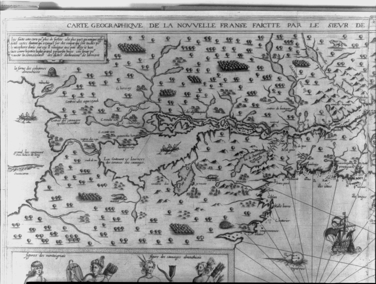
"Carte geographique de la nouvelle Franse faictte par le Sieur de Champlain" LCCN2003688499.jpg - Fæ
Novvs atlas Sinensis. LOC 2002625249-1.tif - Fæ

Novvs atlas Sinensis. LOC 2002625249-1.jpg - Fæ
Novvs atlas Sinensis. LOC 2002625249-2.tif - Fæ

Novvs atlas Sinensis. LOC 2002625249-2.jpg - Fæ
Novvs atlas Sinensis. LOC 2002625249-3.tif - Fæ

Novvs atlas Sinensis. LOC 2002625249-3.jpg - Fæ
Novvs atlas Sinensis. LOC 2002625249-5.tif - Fæ

Novvs atlas Sinensis. LOC 2002625249-5.jpg - Fæ
Novvs atlas Sinensis. LOC 2002625249-6.tif - Fæ

Novvs atlas Sinensis. LOC 2002625249-6.jpg - Fæ
Arbre Oraculaire (Arbre Sec, Arbre Sol) avec les symboles du Soleil et de la Lune (Ebstorf map, zoom).jpg - M.Dulery19

Urbano Monti — World Map as of 1587.jpg - Mattes

Ebstorfer World Map (Samarcha — fragment).jpg - Niklitov

Nova Et Accvratissima Totius Terrarvm Orbis Tabvla - Atlas Maior, vol 1, map 1 - Joan Blaeu, 1667 - BL 114.h(star).1.(1).jpg - JhealdBot

Imperii Sinarvm Nova Descriptio - Atlas Maior, vol 11, map 12 - Joan Blaeu, 1667 - BL 114.h(star).11.(12).jpg - JhealdBot

Pecheli Sive Peking - Atlas Maior, vol 11, map 13 - Joan Blaeu, 1667 - BL 114.h(star).11.(13).jpg - JhealdBot

Xansi… - Atlas Maior, vol 11, map 14 - Joan Blaeu, 1667 - BL 114.h(star).11.(14).jpg - JhealdBot

Xensi… - Atlas Maior, vol 11, map 15 - Joan Blaeu, 1667 - BL 114.h(star).11.(15).jpg - JhealdBot
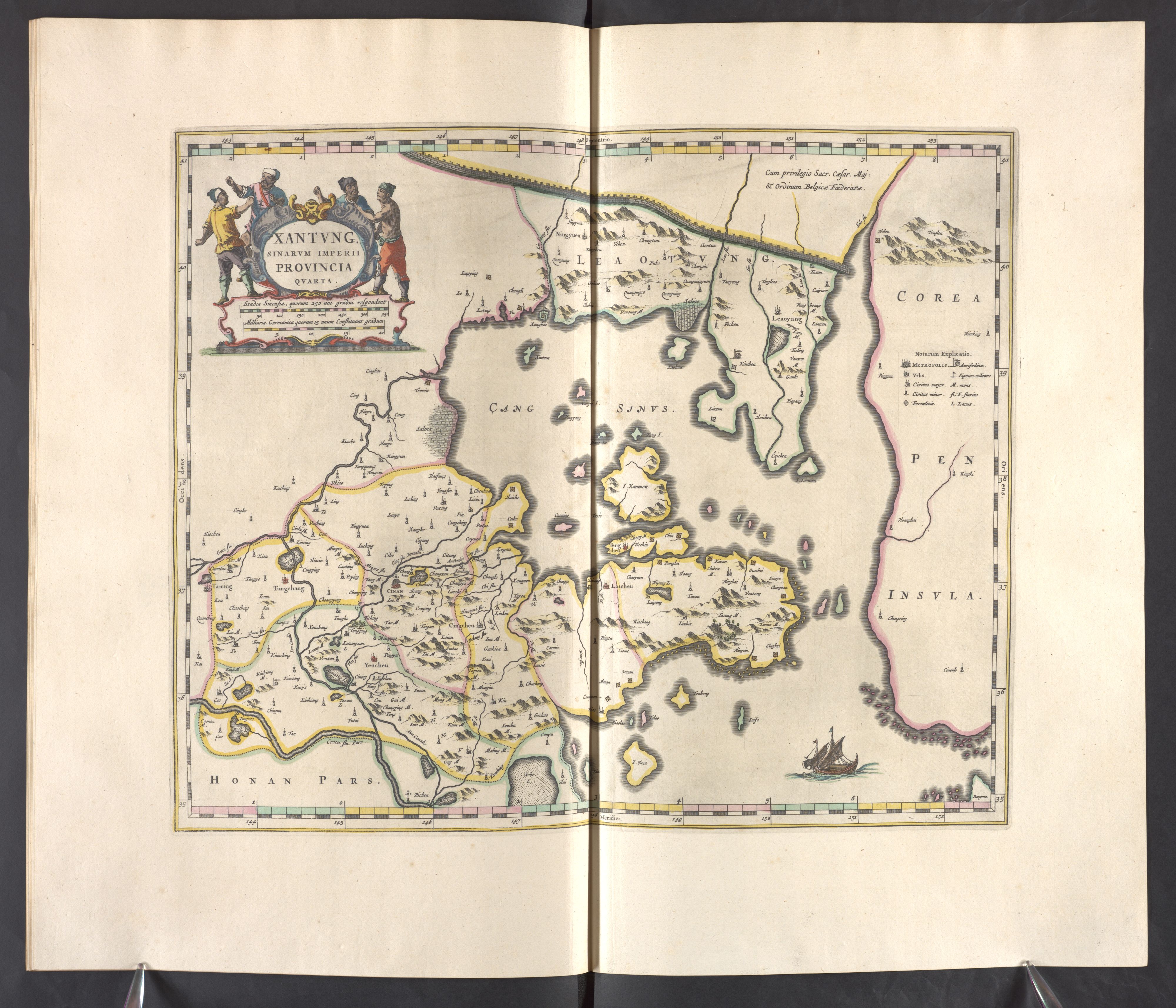
Xantvng - Atlas Maior, vol 11, map 16 - Joan Blaeu, 1667 - BL 114.h(star).11.(16).jpg - JhealdBot

Honan - Atlas Maior, vol 11, map 17 - Joan Blaeu, 1667 - BL 114.h(star).11.(17).jpg - JhealdBot

Svchen - Atlas Maior, vol 11, map 18 - Joan Blaeu, 1667 - BL 114.h(star).11.(18).jpg - JhealdBot

Hvqvang - Atlas Maior, vol 11, map 19 - Joan Blaeu, 1667 - BL 114.h(star).11.(19).jpg - JhealdBot

Kiangsi - Atlas Maior, vol 11, map 20 - Joan Blaeu, 1667 - BL 114.h(star).11.(20).jpg - JhealdBot

Chekiang - Atlas Maior, vol 11, map 22 - Joan Blaeu, 1667 - BL 114.h(star).11.(22).jpg - JhealdBot

Fokien - Atlas Maior, vol 11, map 23 - Joan Blaeu, 1667 - BL 114.h(star).11.(23).jpg - JhealdBot

Qvantvng - Atlas Maior, vol 11, map 24 - Joan Blaeu, 1667 - BL 114.h(star).11.(24).jpg - JhealdBot

Quangsi - Atlas Maior, vol 11, map 25 - Joan Blaeu, 1667 - BL 114.h(star).11.(25).jpg - JhealdBot

Qveichev - Atlas Maior, vol 11, map 26 - Joan Blaeu, 1667 - BL 114.h(star).11.(26).jpg - JhealdBot
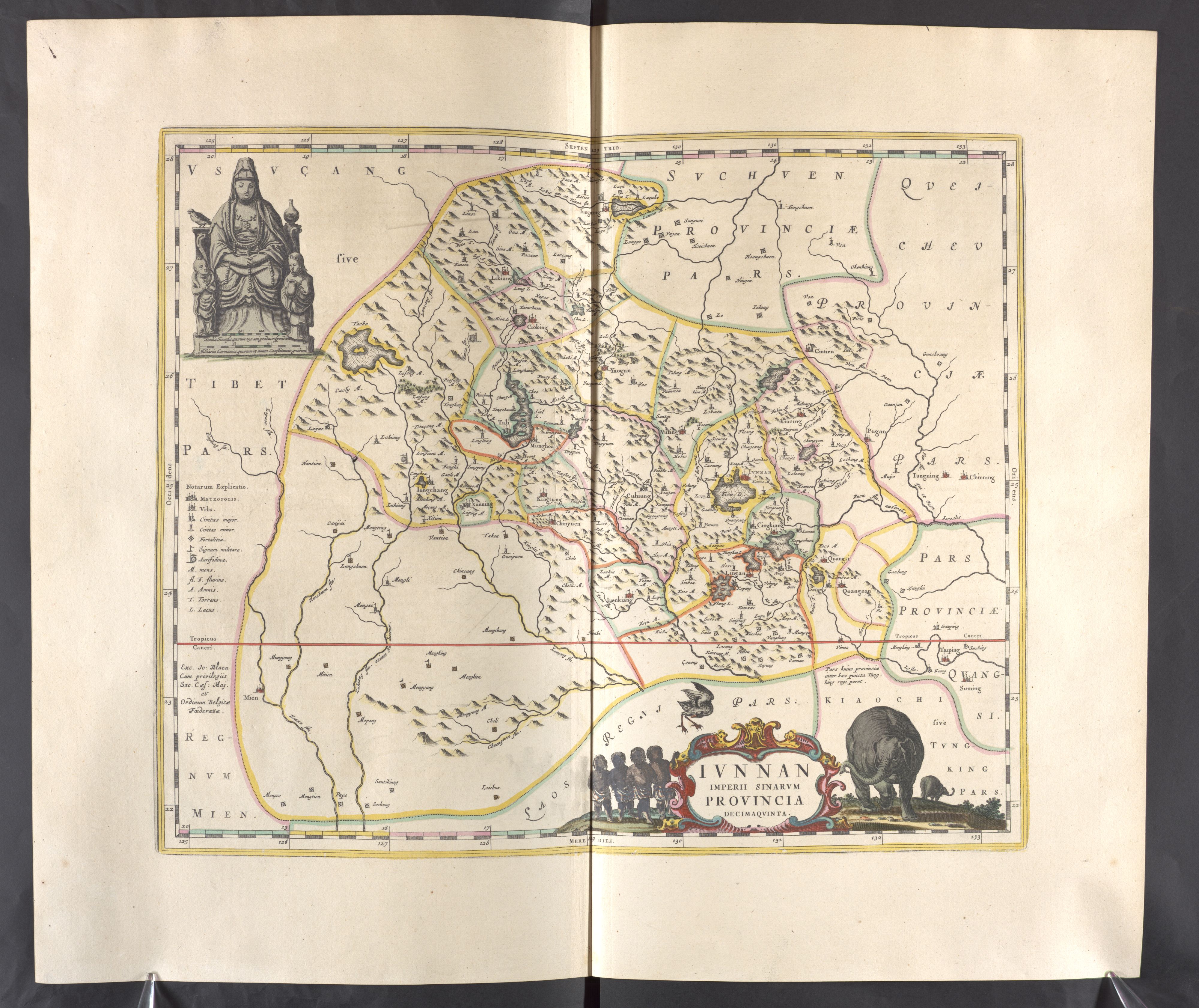
Ivnnan - Atlas Maior, vol 11, map 27 - Joan Blaeu, 1667 - BL 114.h(star).11.(27).jpg - JhealdBot

Cellarius Harmonia Macrocosmica - Hemisphaerii Borealis Coeli et Terrae Sphaerica ScenographiaFXD.jpg - Pixel8tor

Kaart van Japan met bijkaart van Nagasaki Imperivm Japonicvm per regiones digestvm sex et sexaginta atqve ex ipsorvm Japonensivm mappis (titel op object), NG-501-87.jpg - Mr.Nostalgic

The Kingdome of China newly augmented by I.S. 1626.jpg - Balkanique

A New Mappe Of The Romane Empire.jpg - Balkanique

A New and Correct Map of England and Wales, Now Called South Britain 1717.jpg - PKM

B26056005B - Molvccae insvlae celeberrimae.jpg - NLSingapore

David de Meyne2.jpg - Sigfrøðr

Imperii Sinarum nova descriptio - btv1b53179352v (1 of 2).jpg - Gzen92Bot

Huquang imperii sinarum provincia septima - (tiré du P. Martini) ; excud. Joannes Blaeu - btv1b10101758k.jpg - LlywelynII

Quangsi sinarum imperii provincia decimatertia - (tiré du P. Martini) ; exc. Joannes Blaeu - btv1b5963090n.jpg - Gzen92Bot

Imperium Japonicum per regiones digestum sex et sexaginta atque ex ipsorum Japonensium mappis descriptum ab Hadriano Relando. Millaria Germanica communia 15 (=Om. 050 ; 1 - 2 200 000 environ) - Viro Perillustri... - btv1b8492400j.jpg - Gzen92Bot

Pecheli sive Peking imperii sinarum provincia prima - (tiré du P. Martini) - btv1b59630415.jpg - Gzen92Bot

Xantung, sinarum imperii provincia quarta - (tiré du P. Martini) - btv1b5963044d.jpg - Gzen92Bot

Aethiopia inferior, vel exterior, partes magis septentrionales, quae hic desiderantur, vide in tabula Aethiopiae superioris - (Joan Blaeu) - btv1b531432316.jpg - Gzen92Bot

Suchuen imperii sinarum provincia sexta - (tiré du P. Martini) ; excudit Joannes Blaeu - btv1b101017574.jpg - Gzen92Bot

Chekiang imperii sinarum provincia decima - (tiré du P. Martini) ; J. Blaeu excudebat - btv1b5963067d.jpg - Gzen92Bot

Orbis vetus juxta Strabonem - (tiré de Cellarius) - btv1b5963496h.jpg - Gzen92Bot
Quantung imperii sinarum provincia duodecima - (tiré du P. Martini) ; excudit Joannes Blaeu - btv1b85951139.jpg - Gzen92Bot

Dorset Shire - By H. Moll Geographer - btv1b53056183v.jpg - Gzen92Bot

Honan imperii sinarum provincia quinta - (tiré du P. Martini) - btv1b5963047n.jpg - Gzen92Bot

Imperii Sinarum nova descriptio - btv1b84415340.jpg - Gzen92Bot

Kiangsi imperii sinarum provincia octava - (tiré du P. Martini) ; excudebat Joannes Blaeu - btv1b5963061x.jpg - Gzen92Bot

Xansi imperii sinarum provincia secunda - (tiré du P. Martini) ; exc. Ioannes Blaeu - btv1b10101753b.jpg - LlywelynII

Cornwal - By H. Moll Geographer - btv1b53056815h.jpg - Gzen92Bot

Fokien imperii sinarum provincia undecima - (tiré du P. Martini) ; excud. Ioannes Blaeu - btv1b5963074j.jpg - Gzen92Bot

Xensi imperii sinarum provincia tertia - (tiré du P. Martini) ; excudebat Ioannes Blaeu - btv1b5963053c.jpg - Gzen92Bot

Iunnan imperii sinarum provincia decimaquinta - (tirée du P. Martini) ; exc. Jo. Blaeu - btv1b5963095q.jpg - Gzen92Bot

Imperii Sinarum nova descriptio - btv1b5963029q.jpg - Gzen92Bot

Devon Shire - By H. Moll Geographer - btv1b53056863p.jpg - Gzen92Bot

Queicheu imperii sinarum provincia decimaquarta - (tirée du P. Martini) ; Exc. I. Blaeu - btv1b5963093w.jpg - Gzen92Bot

Pecheli, sive Peking, Imperii Sinarum provincia prima, cum privilegio Sacrae Caesareae Majestatis & ordinum Belgicae Foederatae - btv1b525047297 (1 of 2).jpg - Gzen92Bot

Canibales of the Amazon, 1599 map by de Bry.jpg - Enyavar

Babilon. A New Mappe Of The Romane Empire (cropped).jpg - Geagea

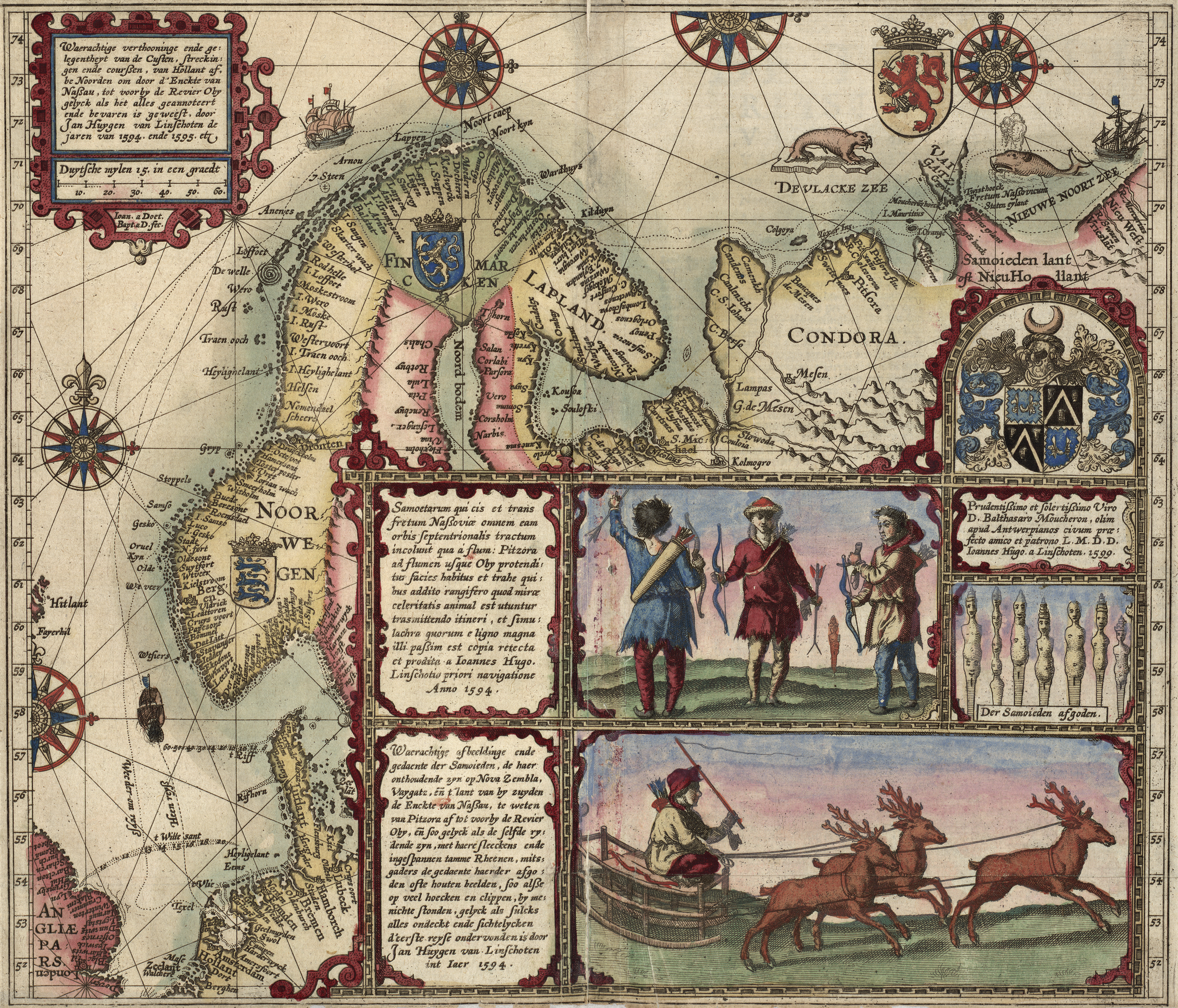
Linschoten Map of Scandinavia.jpg - LlywelynII

Cartouche in a Tartary map by Ortelius 2.jpg - Enyavar