Wikimedi'Òc
Modes d'emploi

Cet album fait partie des albums
Cet album photos contient les sous-albums suivants :


Highest temperature ever recorded in Europe.jpg - Maps.interlude

Isobaras.jpg - Asierog

Isobaras.png - Asierog
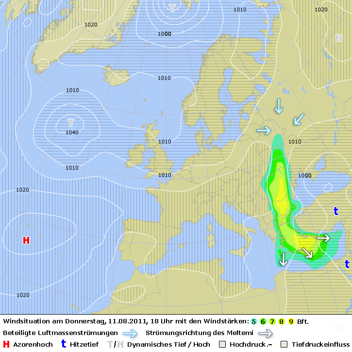
725px Strength of Meltemi Wind.png - MagentaGreen

725px Strength of Meltemi Wind (english Text).png - MagentaGreen

Lux8June3000.gif - Lacunae

Jan2014precipitationdeparture.PNG - Lacunae

LighningmapsNiklas.png - Lacunae

28June2012Lightning.png - Lacunae

Mediterranean Drought Hoerlingetalfig1b.jpg - W!B:

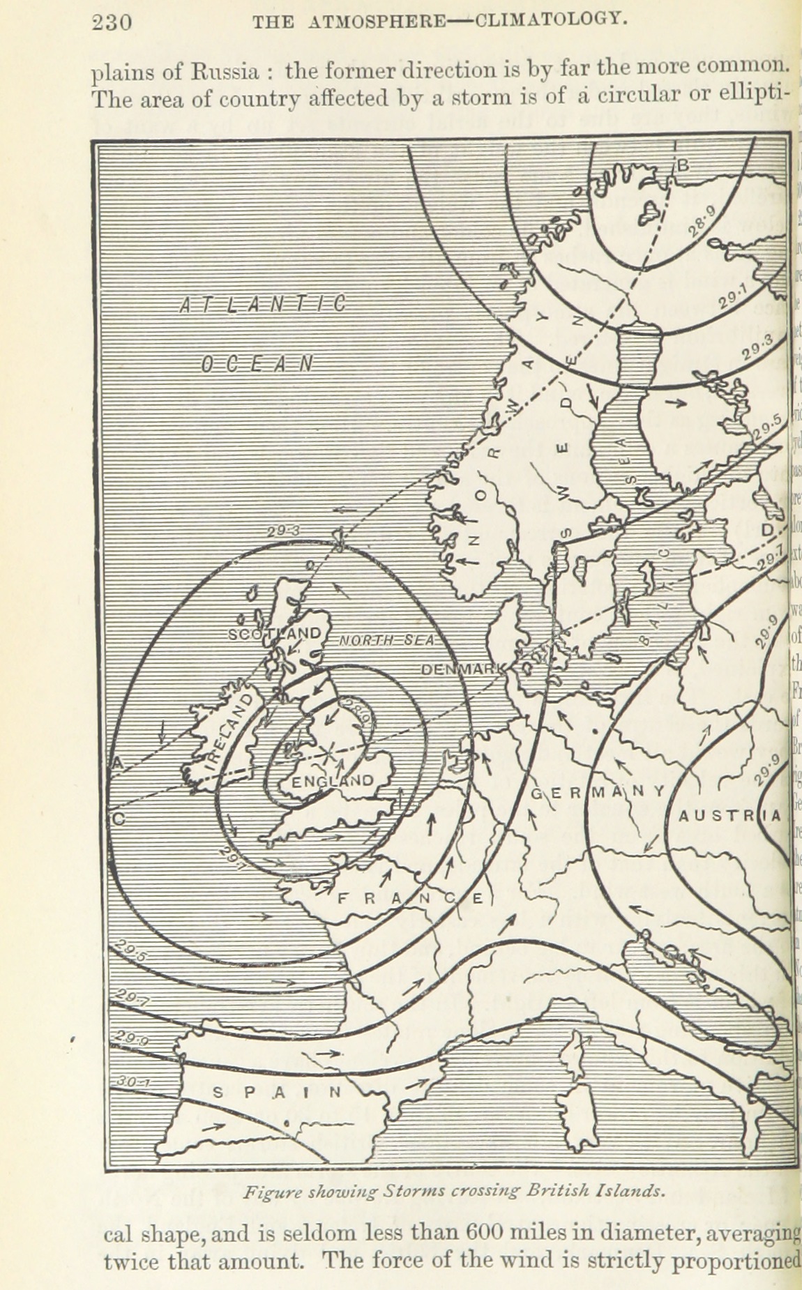
The Quarterly journal of the Geological Society of London (12960390483).jpg - Fæ

23Januar1903Seewarte.PNG - Cmdrjameson

The American Museum journal (c1900-(1918)) (18156826352).jpg - Fæ

Dec2012airpressure.PNG - Lacunae

DesmondAtmosphericRiver.png - Lacunae

Wetterlagen.jpg - Jugrü

Weather-Xaver-Wind.jpg - Markus Bärlocher

DWR29Jan1905.png - Lacunae

DeutscheSeewarte28Jan1905.png - Lacunae
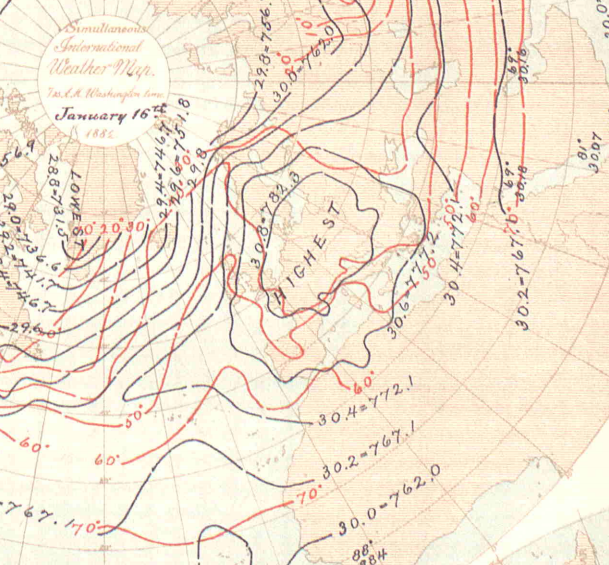
16 January 1882BullIntMetObs.png - Lacunae

High pressure area "Rosi" 27-28 Sept 2017.gif - Lacunae

Image taken from page 136 of 'Von der Ostsee bis zum Nordcap. Eine Wanderung durch Dänemark, Schweden und Norwegen (Illustrated.)' (11197373214).jpg - FlickreviewR 2

Image taken from page 136 of 'Von der Ostsee bis zum Nordcap. Eine Wanderung durch Dänemark, Schweden und Norwegen (Illustrated.)' (16590194335).jpg - Artix Kreiger 2

Image taken from page 136 of 'Von der Ostsee bis zum Nordcap. Eine Wanderung durch Dänemark, Schweden und Norwegen (Illustrated.)' (15970420183).jpg - Artix Kreiger 2

135 of 'Von der Ostsee bis zum Nordcap. Eine Wanderung durch Dänemark, Schweden und Norwegen (Illustrated.)' (11195370176).jpg - Artix Kreiger 2

1265 of 'La Terra, trattato popolare di geografia universale per G. Marinelli ed altri scienziati italiani, etc. (With illustrations and maps.)' (11245555095).jpg - FlickreviewR 2

1267 of 'La Terra, trattato popolare di geografia universale per G. Marinelli ed altri scienziati italiani, etc. (With illustrations and maps.)' (11248807874).jpg - FlickreviewR 2

481 of 'Onze aarde. Handboek der natuurkundige aardrijkskunde ... Met 150 platen en 20 kaartjes in afzonderlijken Atlas' (11287336814).jpg - Artix Kreiger 2
234 of '(Advanced Text-book of Physical Geography.)' (11163139696).jpg - Artix Kreiger 2

65 of 'The Earth and its Inhabitants. The European section of the Universal Geography by E. Reclus. Edited by E. G. Ravenstein. Illustrated by ... engravings and maps' (11127540603).jpg - Artix Kreiger 2

November 2010 windstorm victim nations.png - OgreBot

60-year-daily-minimum-temperatures-at-2m-height.jpg - HappeJ

Koppen-Geiger Map Europe future.svg - NVergopolan

Koppen-Geiger Map Europe present.svg - NVergopolan

Koppen-Geiger Map Northern Europe future.svg - NVergopolan

Koppen-Geiger Map Southern Europe future.svg - NVergopolan

Koppen-Geiger Map Western Europe future.svg - NVergopolan
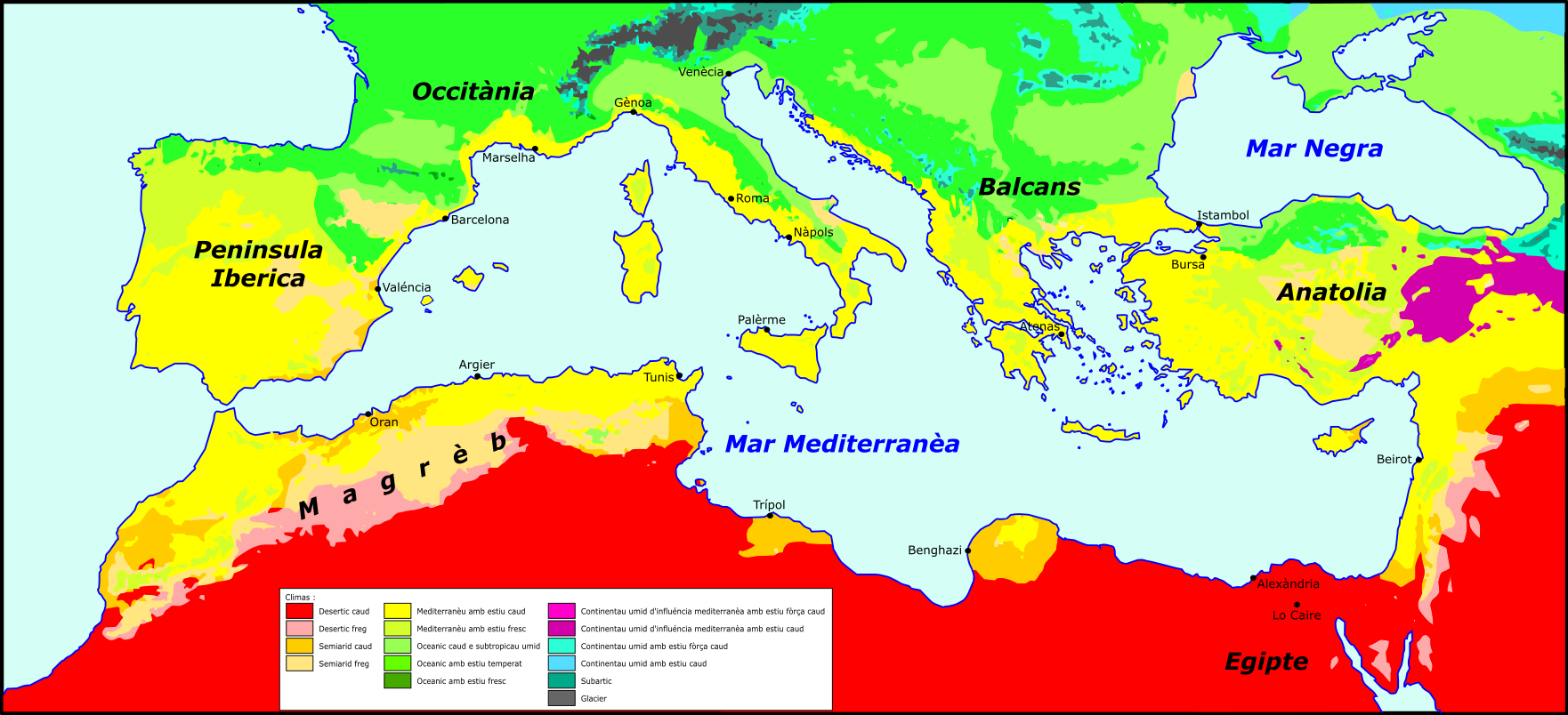
Mar Mediterranèa - Clima.png - Nicolas Eynaud

Map of European Tornado Alley.png - Romaine

Weuropelsta tmo 2006201.jpg - Commons is in a thing

2020 August CPC Europe total precipitation.png - Matthiasb

2020 August CPC Europe percent of normal precipitation.png - Matthiasb
HW03 Impacts Legend.png - Crossct
ECDM 20220524 Alpine region drought.pdf - Lupe

Minerva atlas 1926 (142708812).jpg - Polona Upload

Minerva atlas 1926 (142708813).jpg - Polona Upload

Minerva atlas 1926 (142708814).jpg - Polona Upload

Precipitation map - OCT2001.gif - Bananas222

Europe remains affected by drought this Autumn (Copernicus).jpg - OptimusPrimeBot

Klimatska klasifikacija SJ EUR.png - BornaMus

Količina oborina SJ EU.png - BornaMus
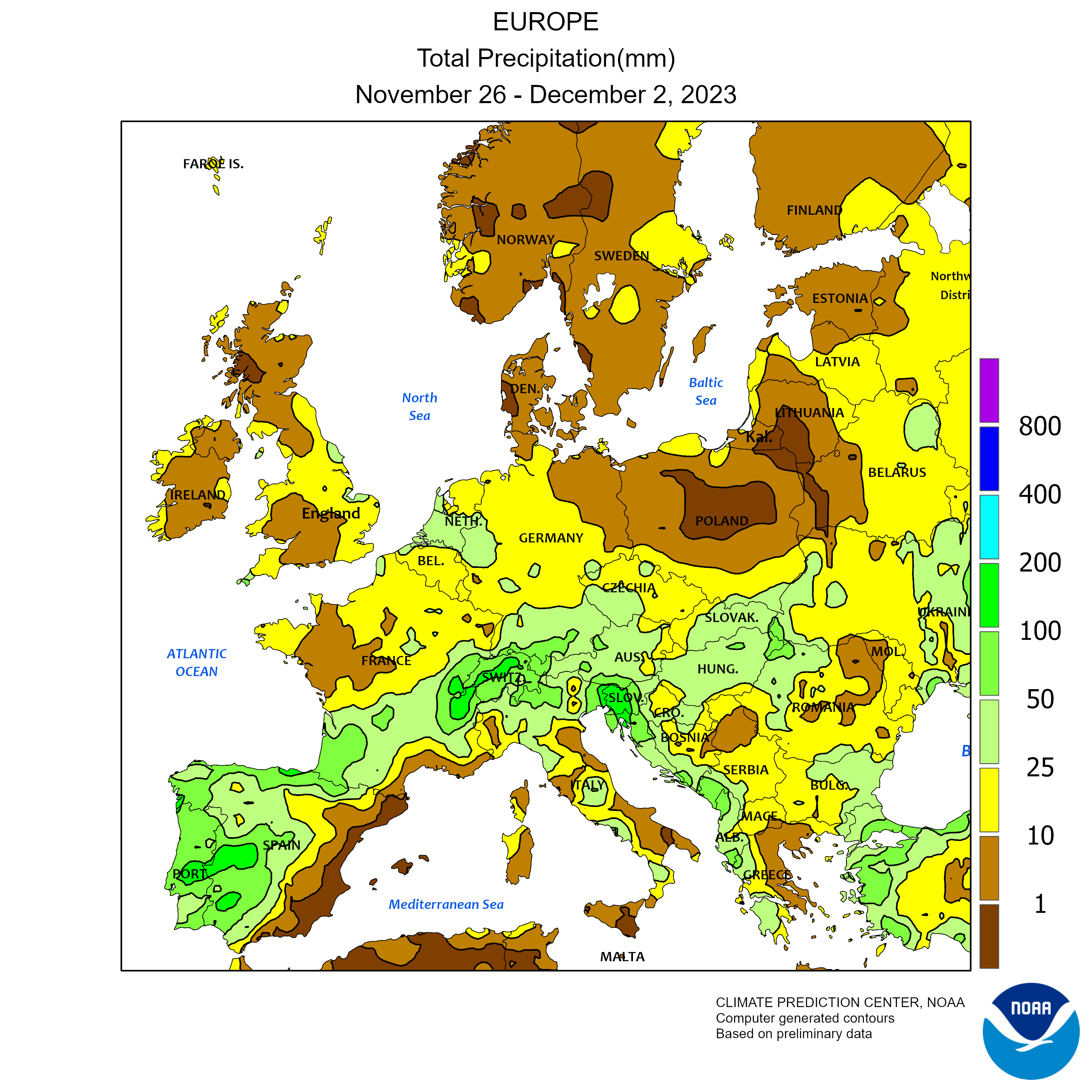
Wcpcp1 20231126-20231202 Europe total precipitation.png - Lupe

USDA hardiness zones of Europe.svg - Cartoffel

Climates (Köppen) of Europe.gif - Moodylo333
ECDM 20240912 ST Central Eastern Europe.pdf - OptimusPrimeBot
ECDM 20240916 ST Central Eastern Europe.pdf - Lupe

2024-09-11--23 synops(svg)ver2'2.png - W!B: