Wikimedi'Òc
Modes d'emploi

Cet album fait partie des albums
Cet album photos contient les sous-albums suivants :


Malacca Sultanate Map 06-03-2025.png - Malayeditz

Map of Malay Archipelago in 15th century.png - Malayeditz
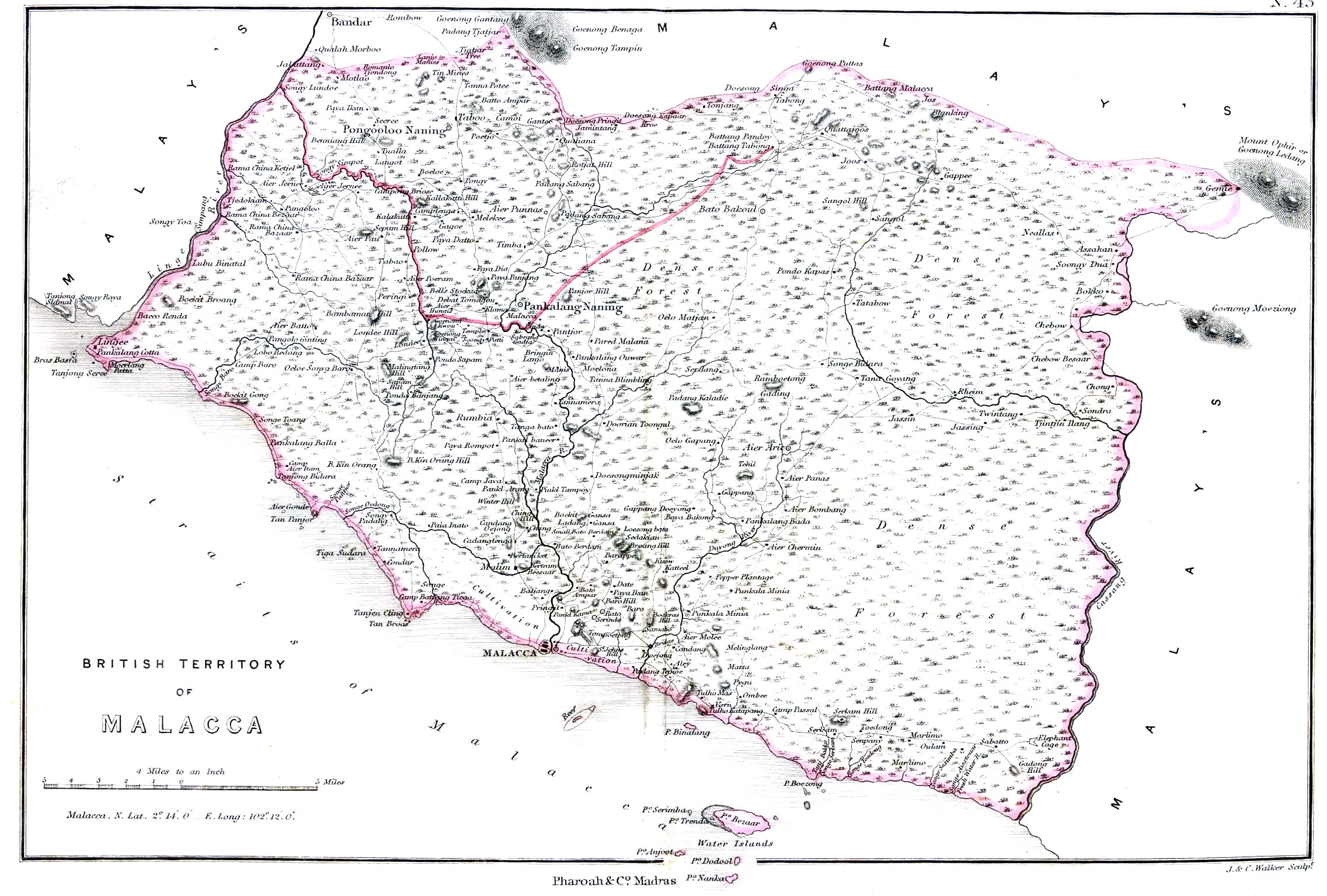
Malacca1854.jpg - Julo

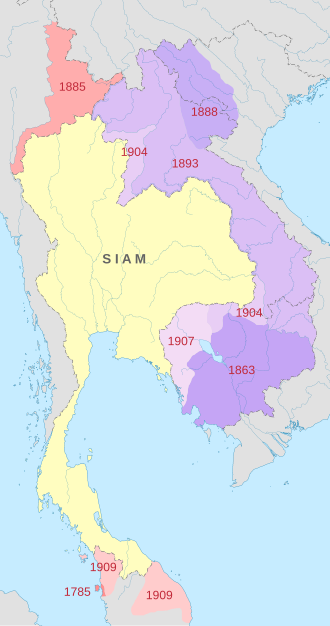
Siamese territorial concessions (1867-1909).gif - Sieger Junge

Japanese forces Borneo.jpg - Nick-D

Federation of Malaya.PNG - Ælfgar

Federatedmalaystates.png - Bluedenim

Siamese territorial concessions (1867-1909) with flags.gif - World Imaging
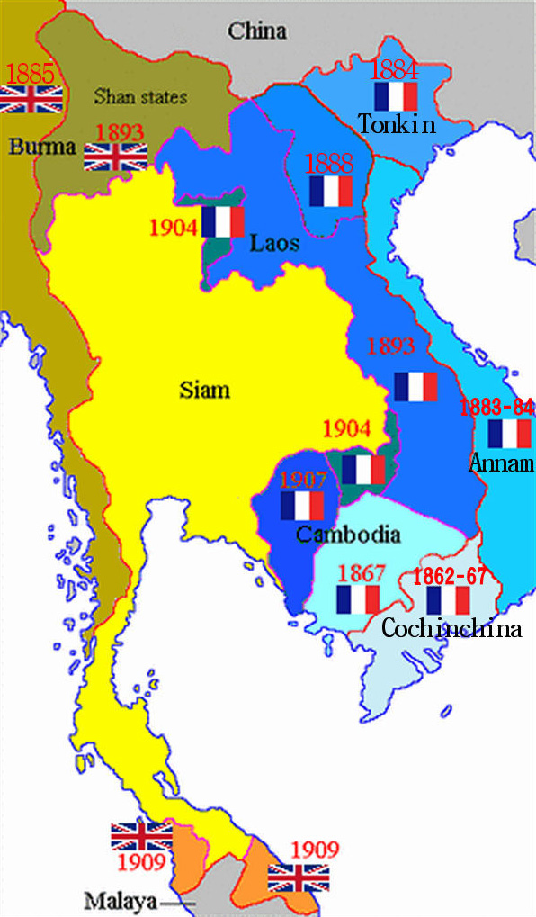
French Indochina expansion.jpg - Ras67

Port Swettenham And Vicinity.jpg - Mdzafri

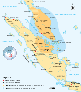
SultanateMalacca.GIF - Zykasaa

ChiTu005.jpg - Zykasaa

PanPan002.jpg - Zykasaa

Map-of-southeast-asia 1000 - 1100 CE.png - Ras67
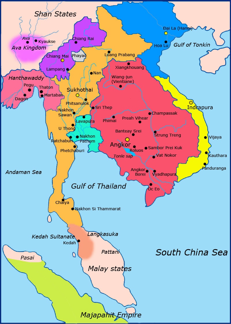
Map-of-southeast-asia 1300 CE.png - Javierfv1212
Map-of-southeast-asia 1400 CE.png - Yourlocallordandsavior

Malacca Sultanate en.svg - Tofeiku

Malacca Sultanate id.svg - Silencemen21
暹罗的领土丧失(1867-1909).png - Sieger Junge

PZSL1889Plate23.png - Dysmorodrepanis

(1860) STRAITS OF MALACCA.jpg - Metilsteiner

Map of southern Labuan marked with estimated Japanese positions and Allied invasion beaches as of April 1945.jpg - Julien1978

Hinduism Expansion in Asia.svg - GinawaSaHapon

Indonesia - Srivijaya (sègles VII-IX).png - Nicolas Eynaud

80LangMap002.jpg - Gunkarta

Malàisia - Periòde coloniau.png - Nicolas Eynaud

Malàisia - Colonizacion dau nòrd de Bornèo.png - Nicolas Eynaud

Map-of-southeast-asia 1400 CE-es.svg - Rowanwindwhistler

Map of northern Labuan marked with estimated Japanese positions and Allied invasion beaches as of April 1945.jpg - Julien1978

Hinduism Expansion in Asia de.svg - Weaveravel

Expanding Boundaries of Sarawak.png - Lubiesque

Malacca Sultanate-pt.svg - Renato de Carvalho Ferreira

Hinduism Expansion in Asia-pt.svg - Weaveravel

Northern Malay Peninsular 1860 version 2.png - Bujo

Fighting on Labuan 10-21 June 1945.jpg - Nick-D

Malacca Sultanate de.svg - Furfur

Hinduism Expansion in Asia-hu.svg - Weaveravel

Hinduism Expansion in Asia-id.svg - Weaveravel

Hinduism Expansion in Asia-es.svg - Weaveravel

Malacca Sultanate zh-hans.svg - Buernia

Hinduism Expansion in Asia-zh-hans.svg - Weaveravel

Map of Siam (territorial cessions).svg - Milenioscuro

Map of Siam and French Indochina.svg - Milenioscuro

Map of the Rattanakosin Kingdom.svg - Milenioscuro

Map-of-southeast-asia 1000 - 1100 CE-es.svg - Rowanwindwhistler

Map-of-southeast-asia 1300 CE-es.svg - Rowanwindwhistler

Map of Siam and French Indochina -by Milenioscuro- (modified Thai language).png - Nix Sunyata

Indochina 1300 CE.png - Ltn12345

Siam Northern Malaya 1900.svg - Derkommander0916

Map of the Sultanate of Sulu.png - Delirium333

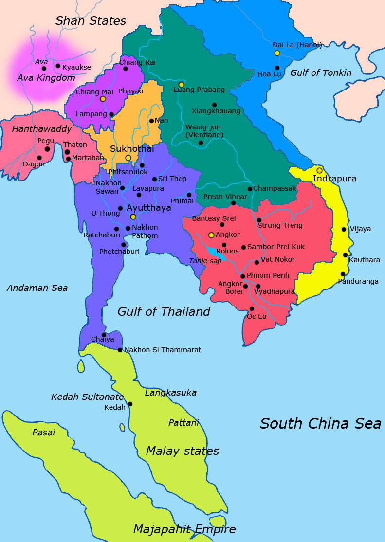
Ayutthaya and Country in mainland south east Asia(1606).svg - Sirrypusar

Chola-Kingdom-Map 0.jpg - Sokkim Mary