Wikimedi'Òc
Modes d'emploi

Cet album fait partie des albums
Cet album photos contient les sous-albums suivants :


Territory ruled by Pedro Fróilaz de Traba.PNG - HombreDHojalata

SieteProvinciasGalicia1753.jpg - Endonartex
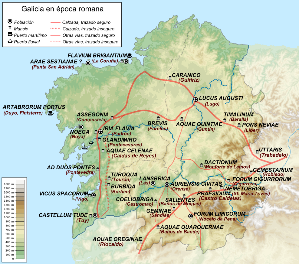
Mapa Galicia epoca romana.png - Lojwe
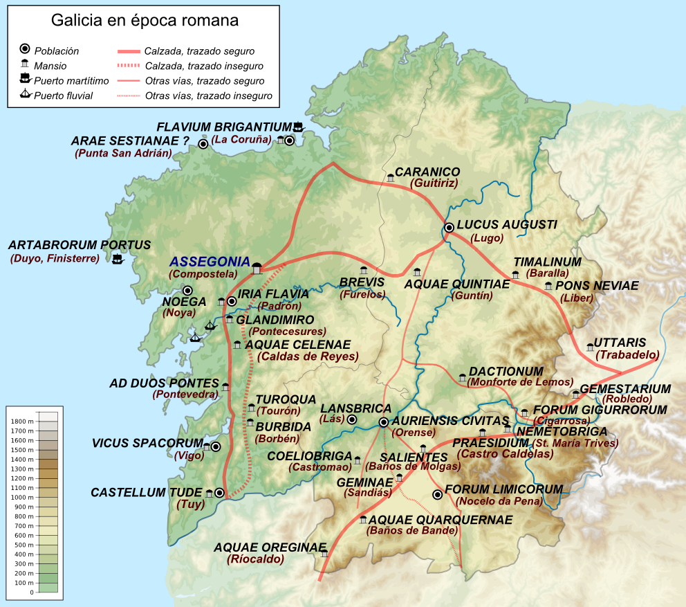
Mapa Galicia epoca romana (Assegonia).png - Lojwe
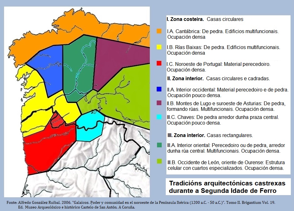
Arquitectura castrexa.jpg - Sobreira

Reino de Galicia - kingdom of Galicia - Jalilkiah.jpg - Alexander Vigo

Europe map Napoleon Blocus.png - Рагин1987

Espagne guerre aout.png - Nécropotame~commonswiki

Espagne guerre octo.png - Nécropotame~commonswiki

Espagne guerre nove.png - Nécropotame~commonswiki

Routes of the Spanish Armada.gif - Kooma
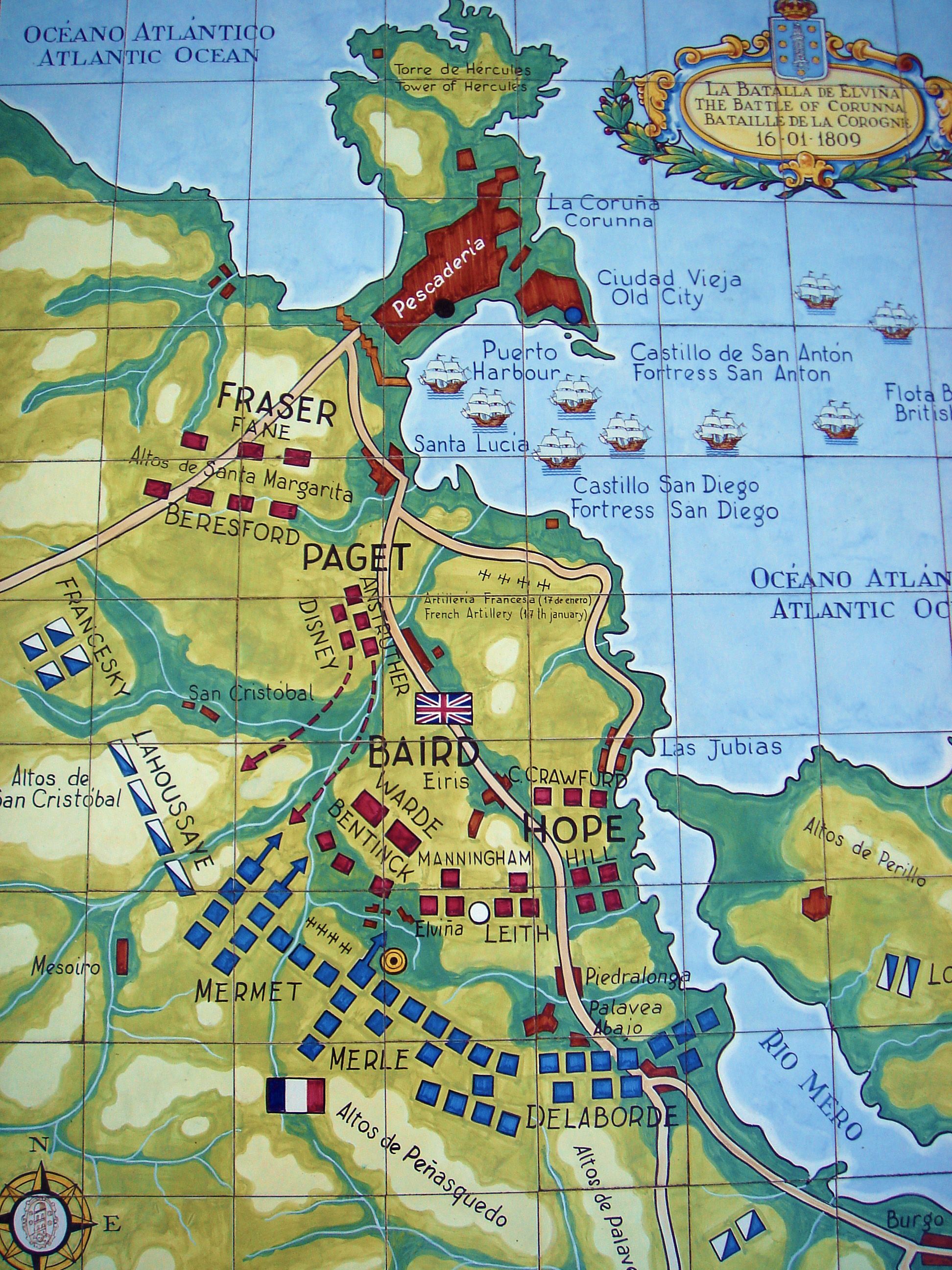
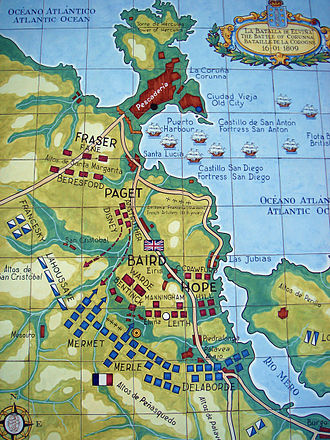
Battle of Corunna.jpg - MarcusBritish

Provincia Betanzos.png - Leoplus
Arte esquematico iberico.png - Locutus Borg
Map Spain 1822.png - Jmadrid
Map Spain Diócesis.png - Jmadrid

Mapa de las Diócesis de España.svg - Alclerus

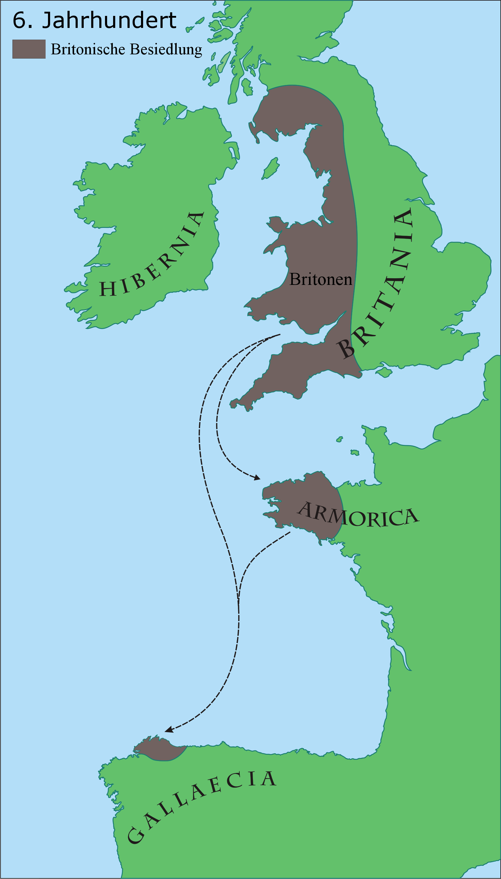
Britonia6hcentury.png - Le Galicien

Map Spain 1833.png - Javitomad

Iberian Peninsula 1811.svg - Waldyrious

Galiciamaptimes.gif - Elvire

Villa Sancti Iacobi.png - Qoan

Avrupa 814.jpg - Vikiyazar

Mapa de España - Decreto de Escosura de 1847.svg - Jadelmo

Mapa de España - Proyecto de reforma de Moret de 1884.svg - Jadelmo

España - División provincial y regional de 1833.svg - Lojwe

Mapa de España - Constitución de 1873.svg - Jadelmo

Mapa de España - Proyecto de regionalización de Silvela - Sánchez de Toca de 1891.svg - Jadelmo

Cultura Castrexa.png - Froaringus

Provinces Crown of Castile 1590.svg - Tyk
Britonen6JHundert.png - XPosition

Britonia6hcentury2.svg - Hel-hama

Region of Galicia.png - Ostiudo

Züge, Landnahmen und Siedlungsgebiete der Nordmänner - 800-1050.png - Mediatus
Empire français 1811.png - Рагин1987

Iberian Peninsula 1811 with locations-es.svg - Rowanwindwhistler

فتح الأندلس 92هـ - 711م.jpg - باسم

Provincia de Galicia en 1800.svg - David Ll L
Territorio de Trastámara (cos castelos).png - One2

Territorio de Trastámara.png - One2

Región de Galica (España) en 1975.svg - David Ll L

Galiza coas sete provincias sobre o territorio actual (1753).jpg - One2

Galiza coas xurisdicións (1753).jpg - One2

Galiza coas sete provincias (1753).jpg - One2

Xurisdicións da provincia da Coruña (1753).jpg - One2

Galiza coas xurisdicións sobre o territorio actual (1753).jpg - One2

Xurisdicións da provincia de Betanzos (1753).jpg - One2

Xurisdicións da provincia de Mondoñedo (1753).jpg - One2

Xurisdicións da provincia de Lugo (1753).jpg - One2
Xurisdicións da provincia de Ourense (1753).jpg - One2

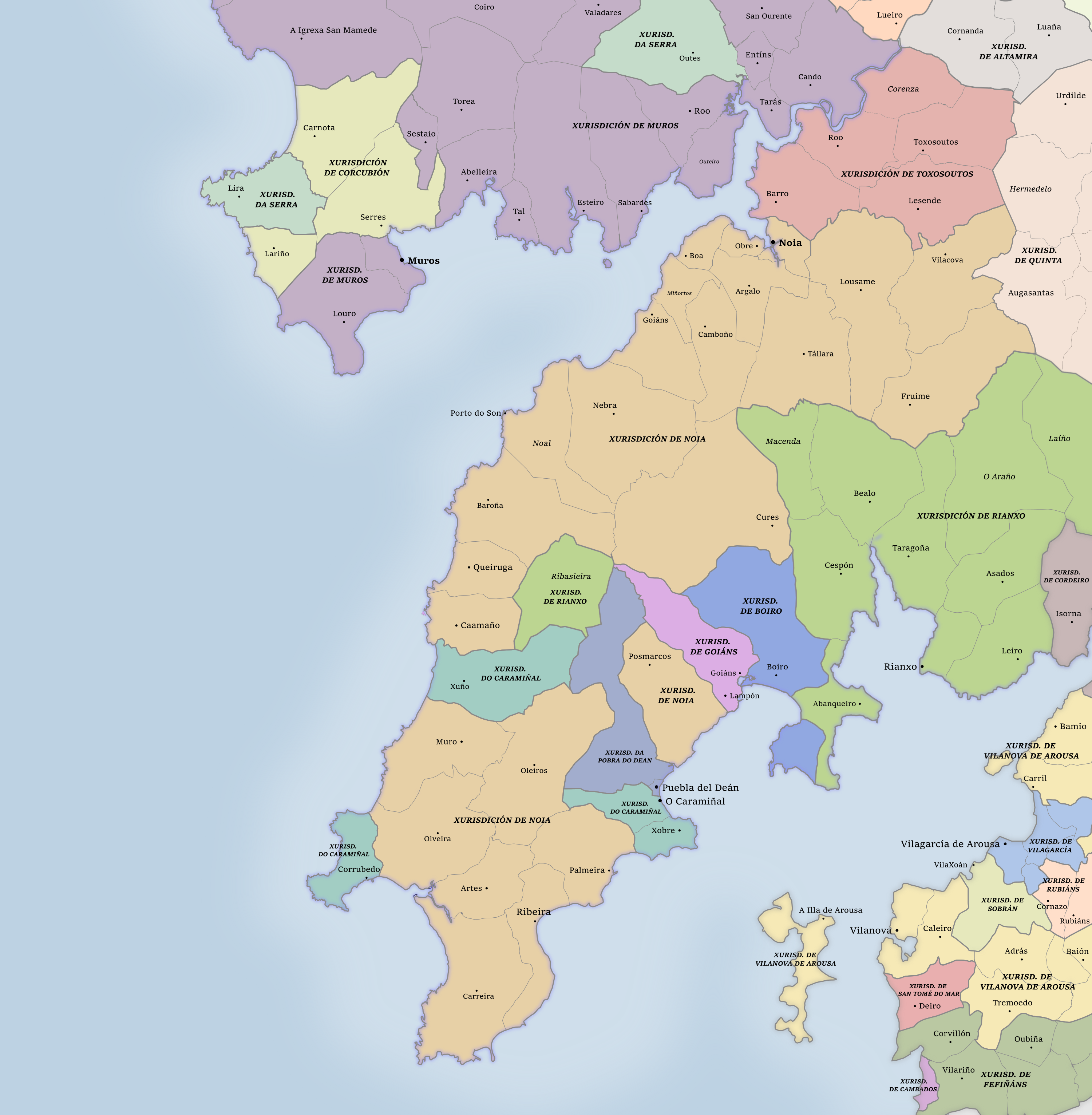
Xurisdicións da provincia de Santiago (1753).jpg - One2

Xurisdicións da provincia de Tui (1753).jpg - One2
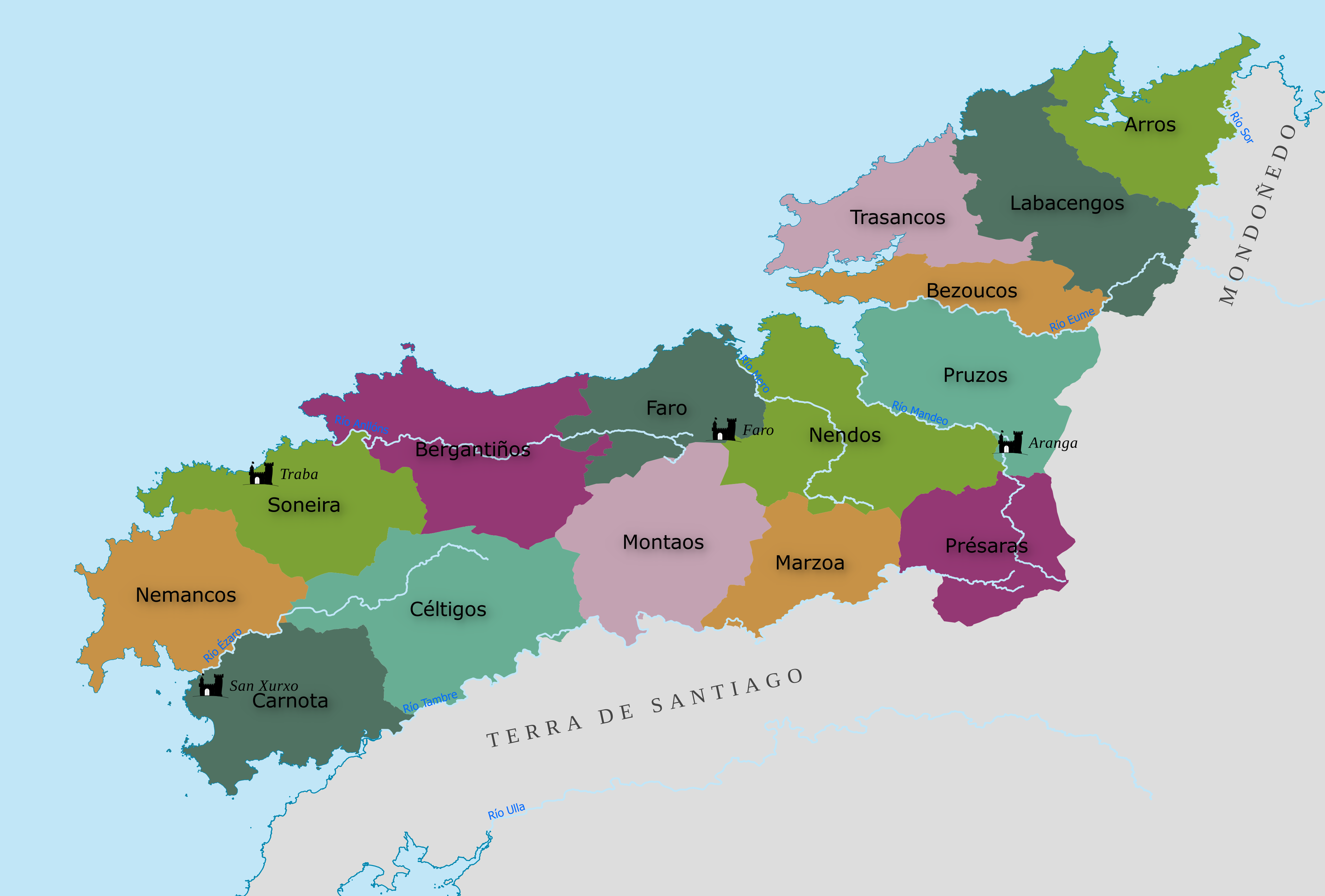
O Barbanza en 1753.png - P.d V

Battle of Corunna from "Illustrated Battles of the Nineteenth Century (By Archibald Forbes, Major Arthur Griffiths, and others.)" (p. 382, 1895) - British Library.jpg - One2

British Library digitised image from page 547 of "History of the War in the Peninsula and in the South of France, from the Year 1807 to the Year 1814 ... From the fourth edition ... With ... engravings".jpg - One2

British Library digitised image from page 623 of "History of the War in the Peninsula and in the south of France, from the year 1807 to the year 1814. vol. 4".jpg - One2

K.v. Spruner's histor. Atlas Nº 40 - Die iberische Halbinsel nach ihrer Kirchlichen Eintheilung.jpg - One2

Estatutos de autonomia 1936.svg - One2

Regiõs direito foral 1975.svg - One2

Britonia6hcentury-ar.jpg - Amr F.Nagy

Europe en 1812 (c. 1854).jpg - One2

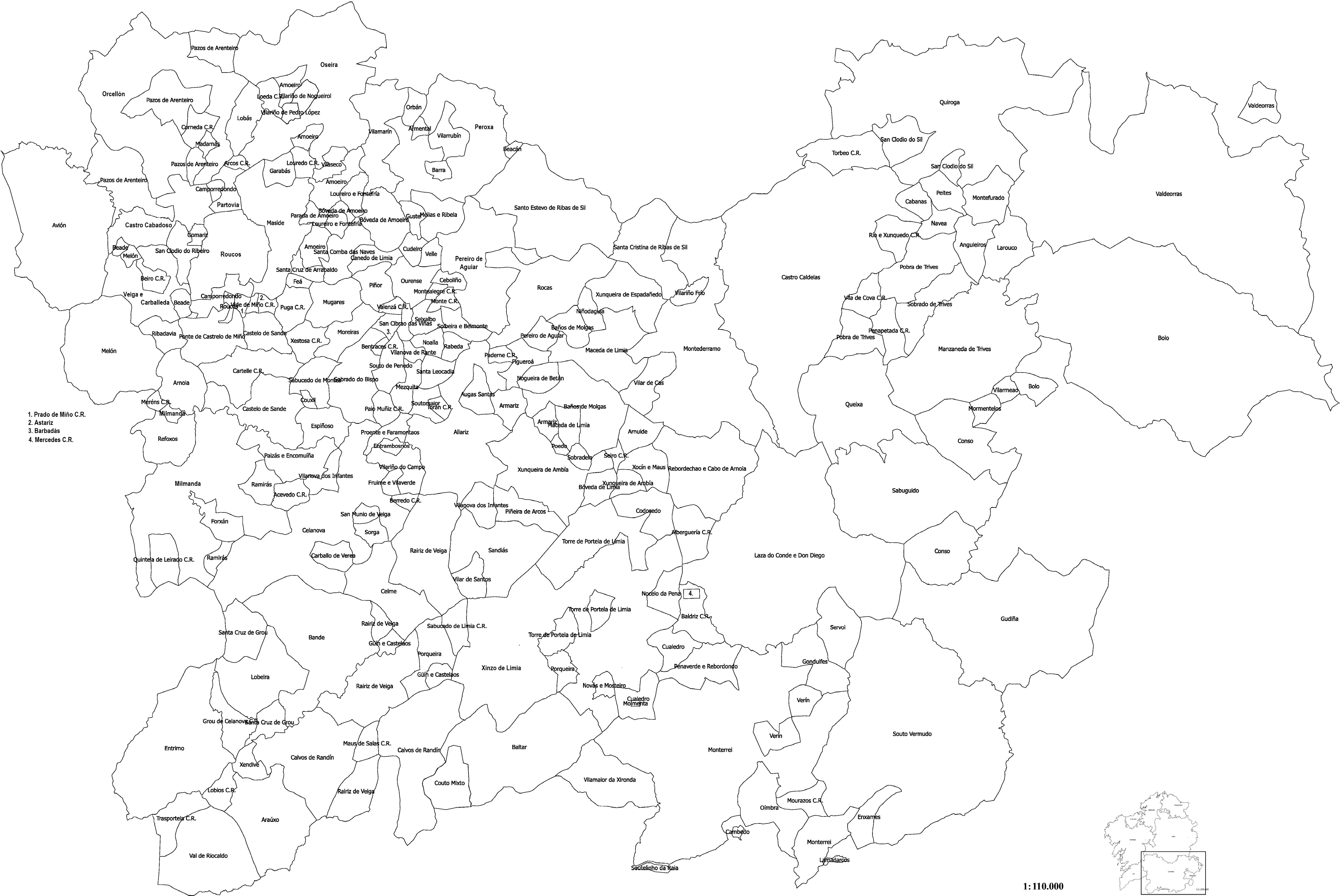
Valores do ferrado superficial em varas qadradas na província de Ourense em 1753.png - One2

Valores do ferrado superficial em varas qadradas na província de Lugo em 1753.png - One2

Valores do ferrado superficial em varas qadradas na província de Mondonhedo em 1753.png - One2

Valores do ferrado superficial em varas qadradas na província de Tui em 1753.png - One2

Valores do ferrado superficial em varas qadradas na província da Crunha em 1753.png - One2

Valores do ferrado superficial em varas qadradas na província de Santiago de Compostela em 1753.png - One2

Valores do ferrado superficial em varas qadradas na província de Betanços em 1753.png - One2

Península Ibérica por volta do ano de 950 segundo a Crónica do mouro Rasis (al-Razi) e a Crónica de 1344.jpg - One2

C. 710 Iberian Peninsula Visigothic Provinces.jpg - Ty's Commons

TRIBOS CALAICAS DO NORTE.png - Enyavar

Map of Galaecia and its territorial subdivisions in Latin and Arabic.jpg - JuanAlv78

Map of Hispania beginning of the 10th century. Place names in Latin-Arabic and "states".jpg - JuanAlv78

Map of Hispania at the beginning of the 10th century. Place names in Latin-Arabic and "states".jpg - JuanAlv78

Map of Hispania beginning of the 10th century.Names in Latin-Arabic and "states".jpg - JuanAlv78

Map of Galaecia and territorial subdivisions. Names in Latin- Arabic..jpg - JuanAlv78

Map of Galaecia´s territorial subdivisions. Names in Latin- Arabic.jpg - JuanAlv78

Territorial subdivisions of Gallaecia. Names in Latin and Arabic..jpg - JuanAlv78

ORNM 01 - O Parroquial Suevo.png - One2
ORNM 01 - O Parroquial Suevo.pdf - One2
ORNM 02 - O encastelamento do Reino.pdf - One2

ORNM 02 - O encastelamento do Reino.png - One2
ORNM 03 - O monacato no Reino.pdf - One2

ORNM 03 - O monacato no Reino.png - One2
ORNM 04 - Mulleres na lírica medieval.pdf - One2

ORNM 04 - Mulleres na lírica medieval.png - One2
ORNM 05 - O Reino no comercio marítimo europeo.pdf - One2

ORNM 05 - O Reino no comercio marítimo europeo.png - One2
ORNM 06 - Produción e comercio do viño.pdf - One2

ORNM 06 - Produción e comercio do viño.png - One2
ORNM 07 - Nobres galegas en desprazamento.pdf - One2

ORNM 07 - Nobres galegas en desprazamento.png - One2
ORNM 08 - As sete provincias galegas.pdf - One2

ORNM 08 - As sete provincias galegas.png - One2