Wikimedi'Òc
Modes d'emploi

Cet album fait partie des albums
Cet album photos contient les sous-albums suivants :


Map for the Silesian and Seven Years Wars (cropped).jpg - Cléééston

Quadi settlement area.png - Zello

Muromian-map.png - Julieta39

Lenguas Rusia Antigua.jpg - Tibicena~commonswiki

Przeworsk2.PNG - Liftarn

Dispersal of Slavs as of 1900 (1910 map).jpg - Quibik

Russia IX secolo.png - Bukkia

Slav-7-8-obrez.png - Gyalu22

Origins 300BC.png - E-960

Origins 200 AD.png - OgreBot

Origins 700.png - Gallico~commonswiki

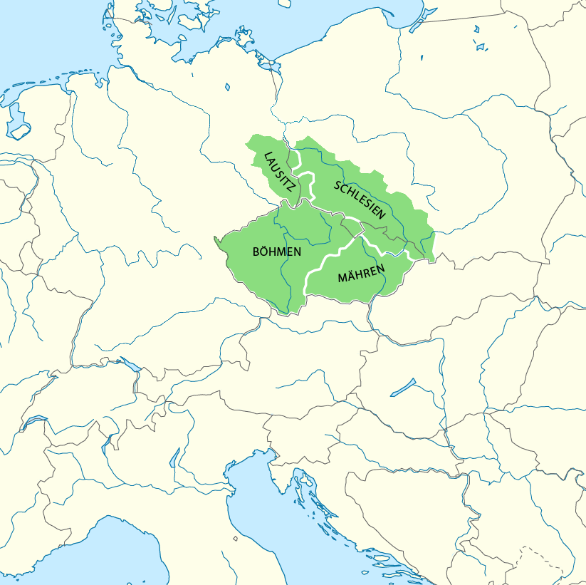
Central Europe (ethnic).JPG - Tryphon

Pannonian sea02.png - WikiEditor2004
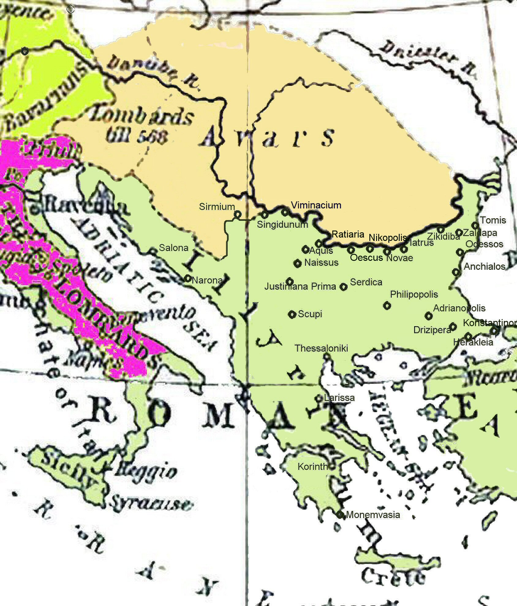
Historical map of the Balkans around 582-612 AD.jpg - File Upload Bot (Magnus Manske)

Pannoniansea currentborders.png - WikiEditor2004

Maps of Slavinia, Pomerania, and Pomerelia.png - AjaxSmack

Gepid kingdom 6th century.png - WikiEditor2004

Mitteleuropa POL wielgórski.PNG - Barry Kent~commonswiki

Mitteleuropa POL Leg wielgórski.PNG - Barry Kent~commonswiki
Mitteleuropa ENG wielgórski.PNG - Barry Kent~commonswiki

Mitteleuropa ENG Leg wielgórski.PNG - Barry Kent~commonswiki

Mitteleuropa no labels wielgórski.PNG - Barry Kent~commonswiki
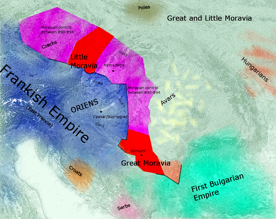
Great Moravia Puspoki's Theory.jpg - Fakirbakir

Finno-ugrian-map.svg - Karland90
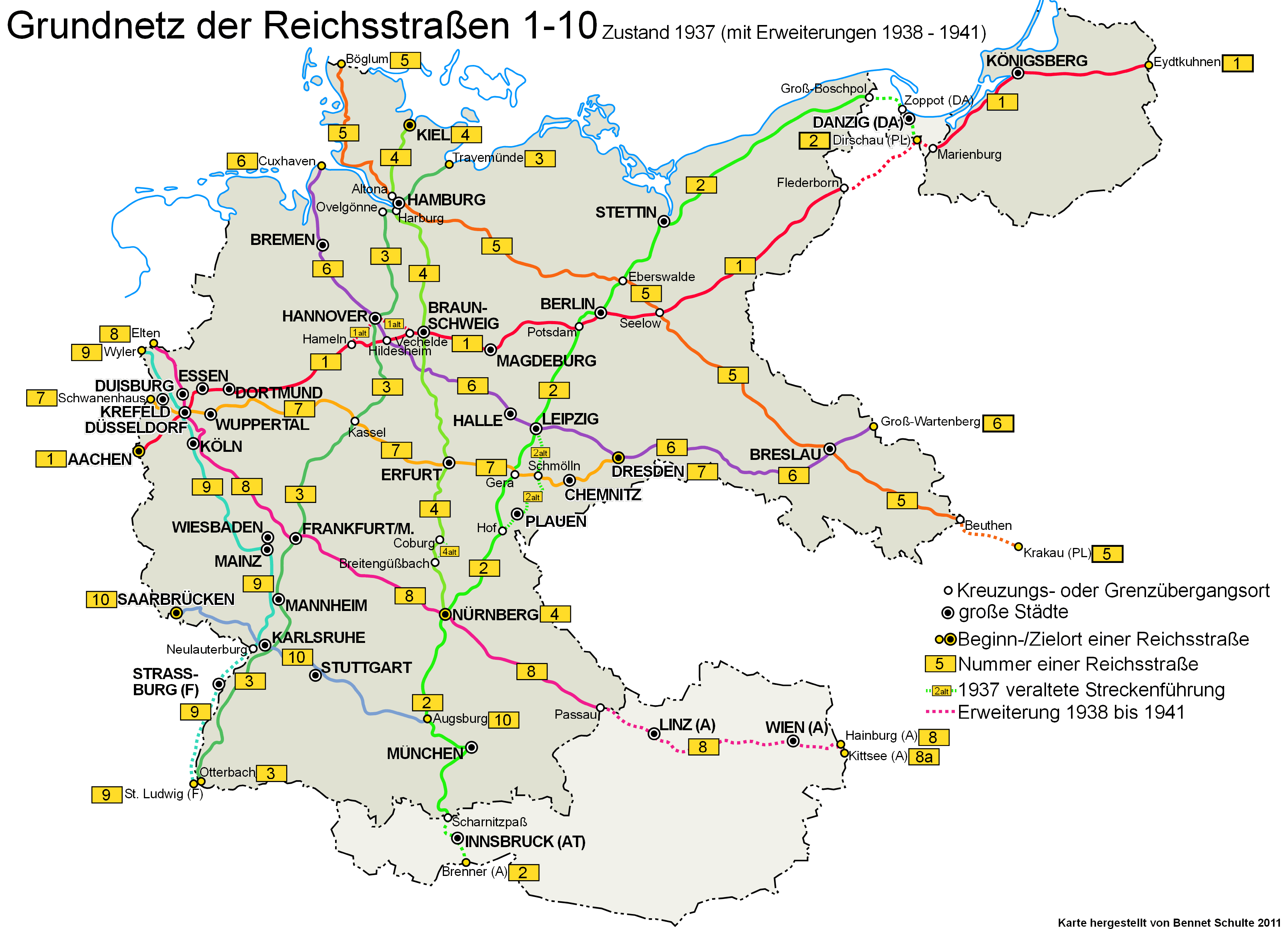
Reichsstrassen 1-10 1937-1945.png - Spazzo

Vucedol culture map.png - WikiEditor2004

Vatin culture.png - WikiEditor2004

Bohemia-ottokar2.jpg - Jirka.h23
Karel-IV..jpg - Jirka.h23

Gutthiuda.jpg - Fakirbakir
Die slawische Besiedlung zwischen dem 5. und 7. Jh. n. Chr.jpg - Silar

Europa Central 1938.png - Brian Clough

Bney hes bney khes in 15th century.svg - Alephreish

Great Moravia Svatopluk.jpg - Jirka.h23

Pannonian sea02-sr.png - WikiEditor2004

Pannonian sea vojvodina-en.png - WikiEditor2004

Pannonian sea vojvodina-sr.png - WikiEditor2004
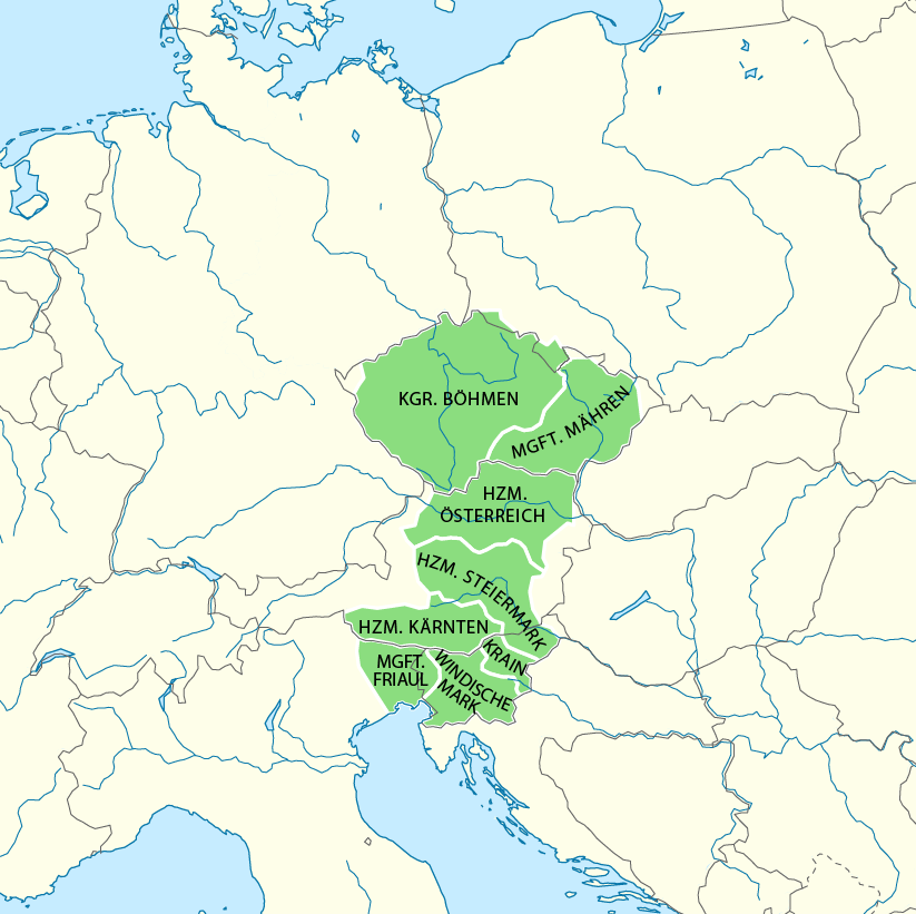
Karte Böhmen unter Karl IV.png - Chumwa
Karte Böhmen unter Ottokar II.png - Valdemar

Istorija Rusije.PNG - Јованвб

Vatin culture-sr.png - WikiEditor2004

Gepid kingdom 6th century-sr.png - WikiEditor2004

Finno-ugrian-map-de.svg - Kopiersperre

Bijelo brdo culture01.png - WikiEditor2004

Bijelo brdo culture02.png - WikiEditor2004

Historical map of the Balkans around 582-612 AD-pt.svg - Renato de Carvalho Ferreira

Mitteleuropa – Völker und Sprachgebiete 1904.jpg - Oltau

Historical map of the Balkans around 582-612 AD-es.svg - Rowanwindwhistler

Central Erope 1572 es.svg - Rowanwindwhistler
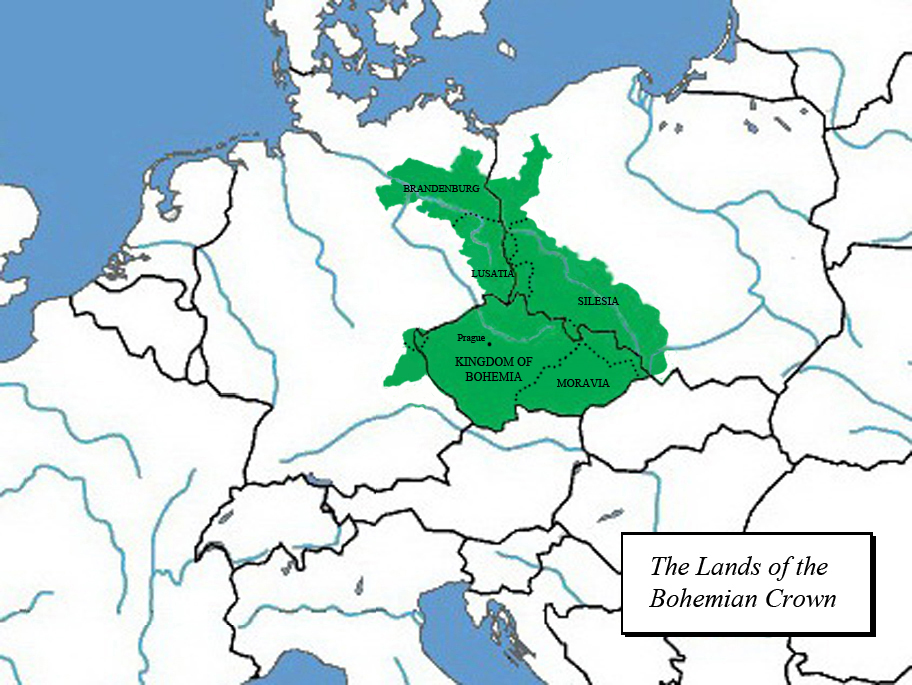
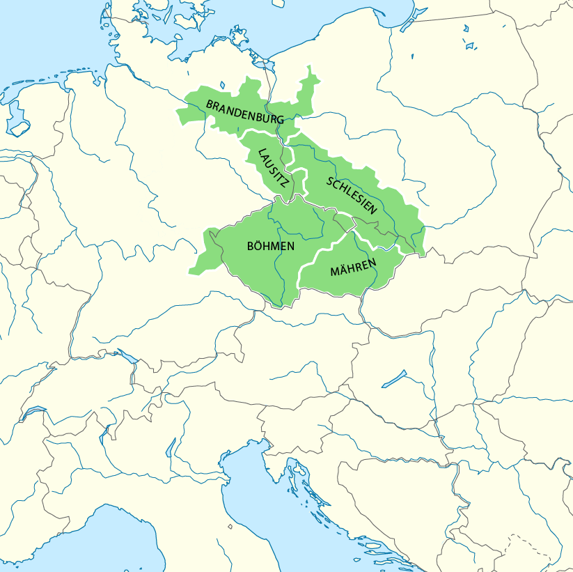
Karte Böhmische Krone.png - Furfur

Kelet-Közép-Európa Mátyás király uralkodásának végén.png - Petolaszlo

Gepid kingdom 6th century - ru.svg - Kaidor

Gepid kingdom 6th century - es.svg - Rowanwindwhistler

MEZ Zone.gif - Kopiersperre

Finnugroj en 1000 (eo).svg - ThomasPusch

Rozšíření Slovanů.png - Martin Vrut

Finno-ugrian-map-es.svg - Rowanwindwhistler

Gepid kingdom 6th century - pt.svg - Renato de Carvalho Ferreira

Finno-ugrian-map-ukr.svg - Vity OKM

212 of 'Славянскій Міръ. Историко-географическое и этнографическое изслѣдованіе. (With maps, etc.)' (11286985195).jpg - Artix Kreiger 2

Gepid kingdom 6th century-hu.svg - Szajci

Historical map of the Balkans around 582-612 AD-hu.svg - Szajci

Great Moravia.svg - Samhanin

Map for the Silesian and Seven Years Wars.jpg - Soerfm

Bohemia under Otakar II and Karel IV CZ.svg - Pavouk

Jagellók országai.jpg - Csanády

Karte Böhmen unter Karl IV.-es.svg - Rowanwindwhistler

1870 Bacon's map of Central Europe by George Washington Bacon, from the Digital Commonwealth - commonwealth ht250717p.jpg - Daderot

Bohemia under Otakar II PL.svg - Smyru

Gepid kingdom 6th century - zh.svg - Vikarna

Bijelo Brdo Culture-it.svg - Mess

Map Austria and the spartitions of Poland 1928-1940 - Touring Club Italiano CART-TRC-60.jpg - Marta Arosio (WMIT)

Map Austria in the napoleonic age 1928-1940 - Touring Club Italiano CART-TRC-61.jpg - Marta Arosio (WMIT)

Map of Austria and Ungheria in 19th century - 1928-1940 - Touring Club Italiano CART-TRC-62.jpg - Marta Arosio (WMIT)
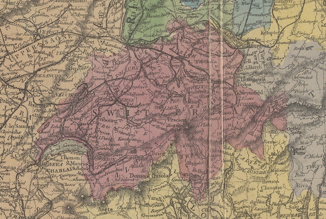
Switzerland. 1870 Bacon's map of Central Europe by George Washington Bacon, from the Digital Commonwealth - commonwealth ht250717p (cropped).jpg - Geagea

Vucedol culture map-sr.png - WikiEditor2004

Finno-ugrian-map-en.svg - Karland90

Slavs-7-8-centuries.png - Qualimac