Wikimedi'Òc
Modes d'emploi

Cet album fait partie des albums


First republic of Armenia-west borders by Woodrow Wilson.png - Rugby471

Vertrag sevres otoman.svg - Thire

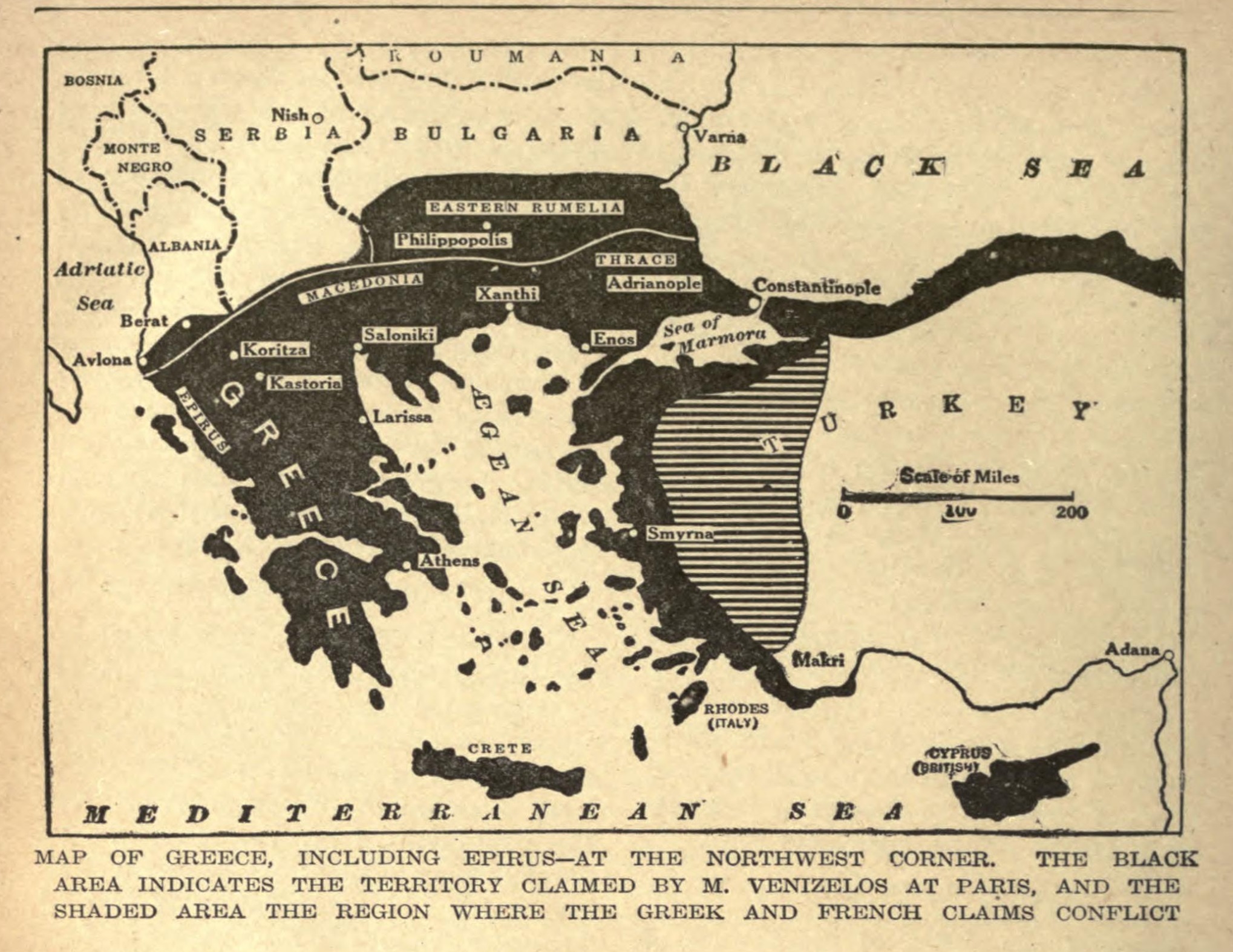
ParisPeace-Venizelos-Map.png - Zoozaz1
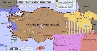
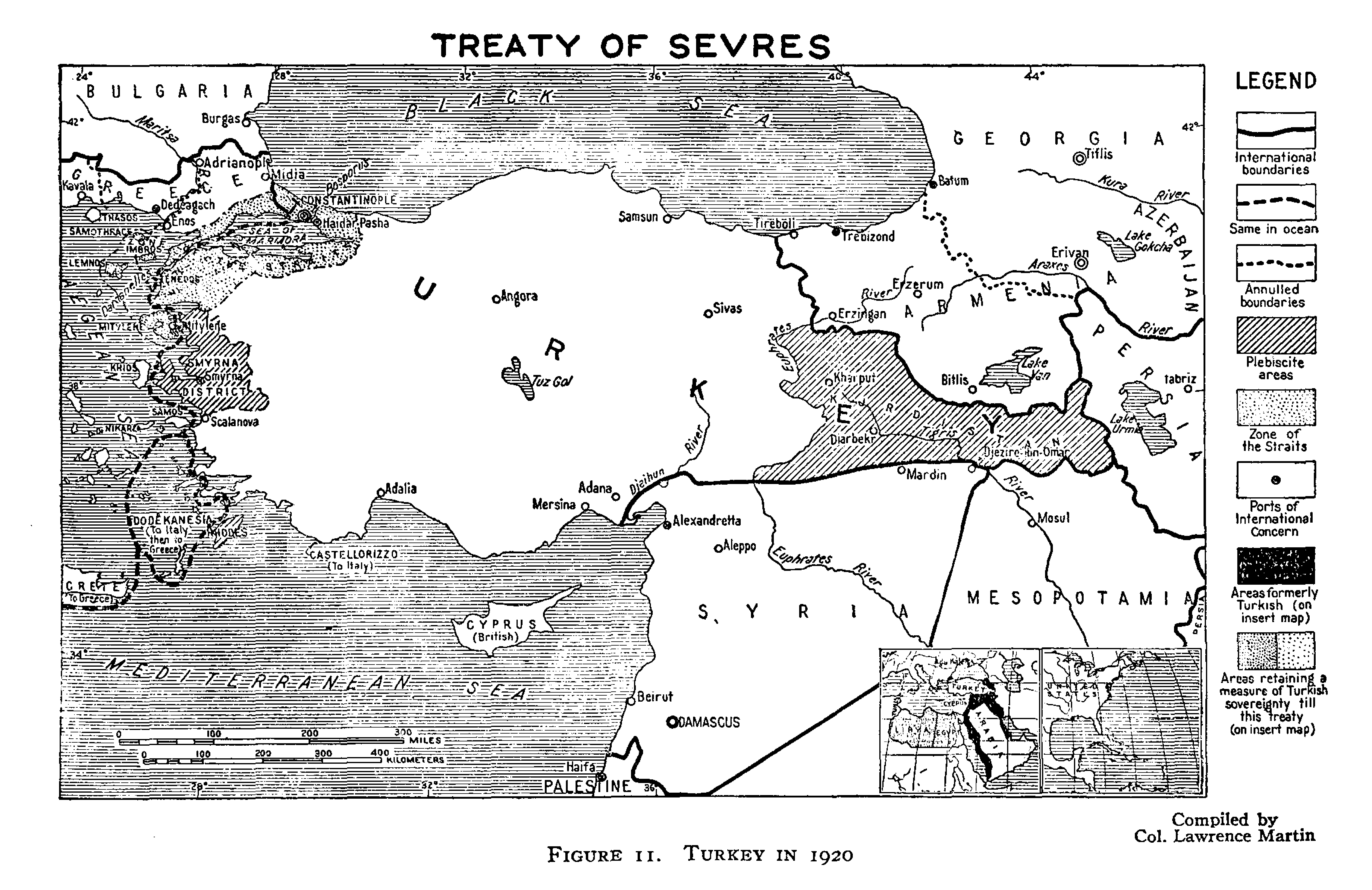
TreatyOfSevres.png - AtilimGunesBaydin

Treaty of Sèvres map partitioning Anatolia.png - Lambiam

Sevres Anlaşması.png - Maderibeyza

Vertrag von sevres.png - Fremantleboy

TreatyOfSevres hu.png - Xia

TreatyOfSevres (corrected) zh t.png - Patrickov

TreatyOfSevres (trad).PNG - GPinkerton

The First Armenian Republic 1918-1920.gif - Centpacrr

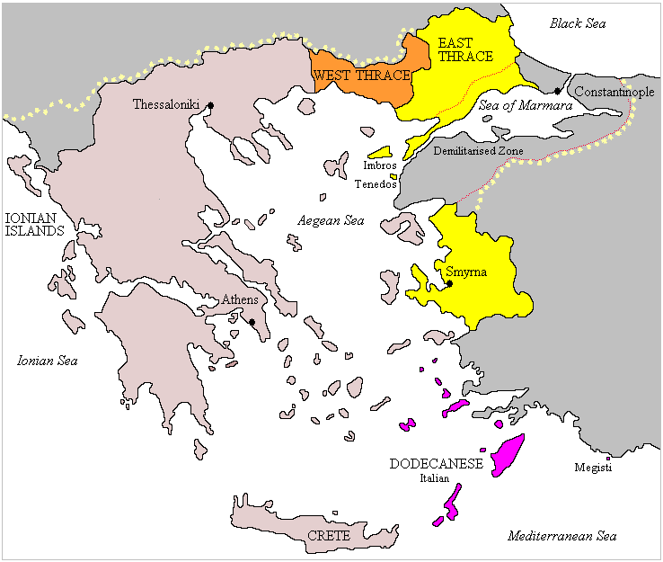
Greece in the Treaty of Sèvres.jpg - Ras67

Treaty sevres otoman de.svg - Don-kun

TreatyOfSevresHEb.jpg - רוליג

Verdrag van Sèvres.png - Armand Sağ~commonswiki
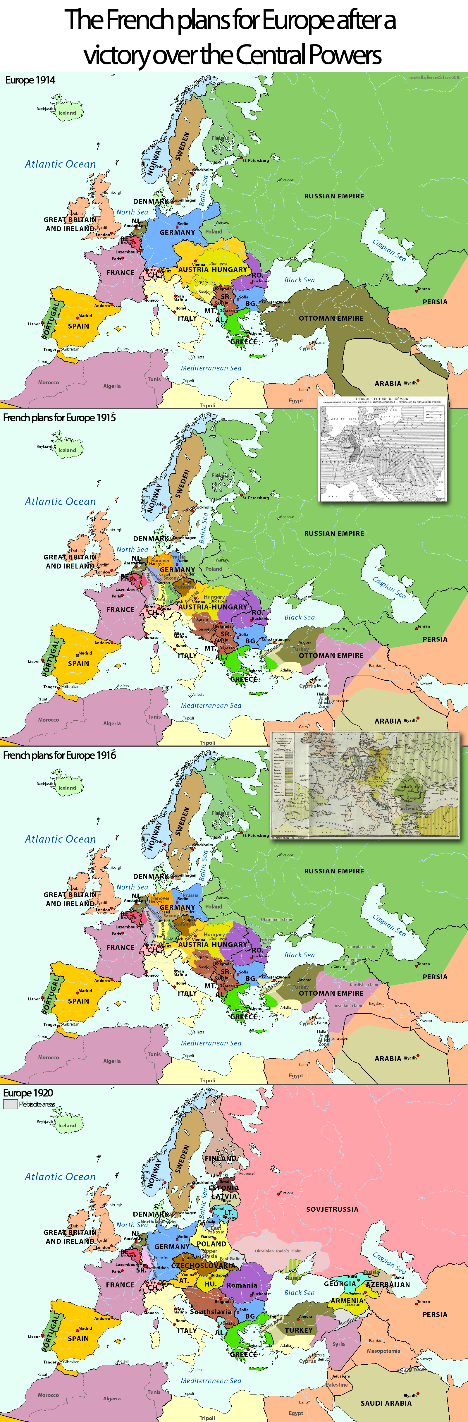
WW1-French-plans.png - Claude Zygiel

FR-WW1-1915-French-plans.png - Exec

FR-WW1-1916-French-plans.png - Exec

FR-WW1-1920.png - Exec

Vertrag sevres otoman ES.svg - Rowanwindwhistler

Treaty sevres otoman ES.svg - Rowanwindwhistler

TratadoDeSevres1920.svg - Rowanwindwhistler

Christians in the Black Sea region (1896).JPG - DragonTiger23

Treaty sevres otoman it.svg - Simoneboscaglia

Map showing the boundaries of Armenia as awarded by President Wilson.jpg - Prince of Nothing05

Republic of Pontus map.svg - Trashpanda
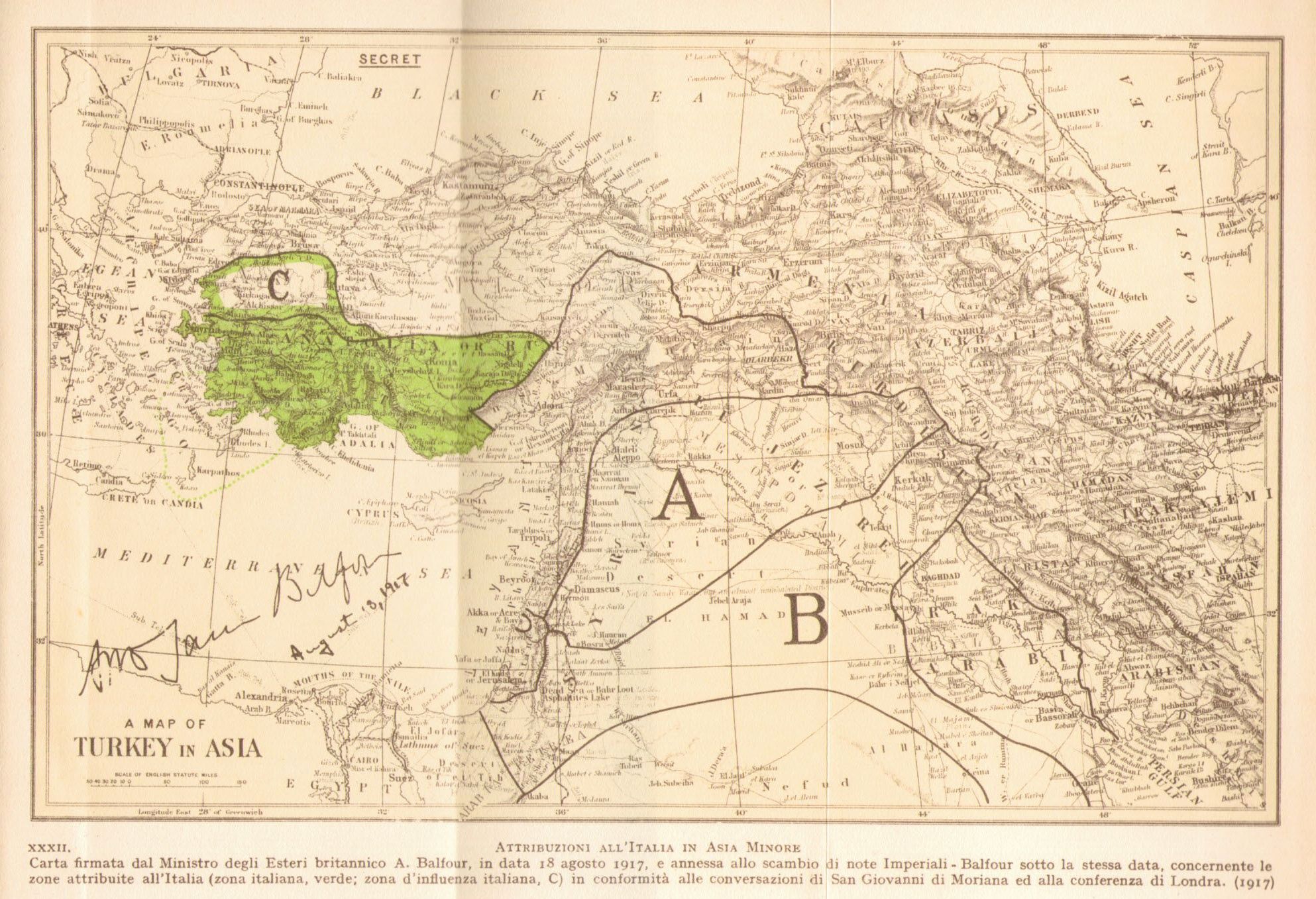
Sfera italiana Turchia 1917.jpg - Xerse~commonswiki

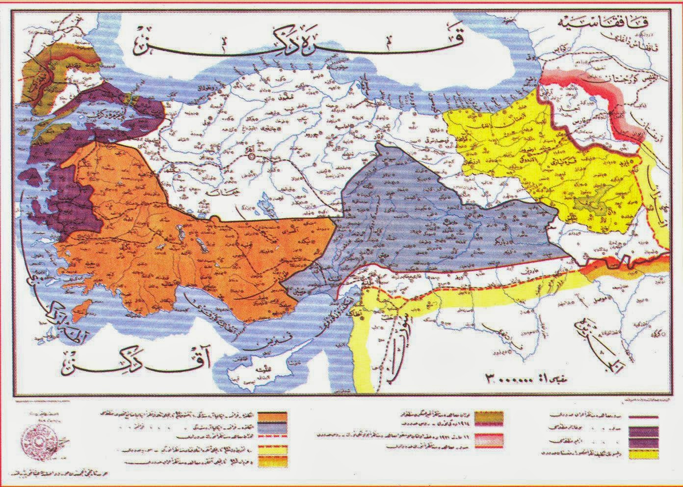
Kurdistan1920.png - WikiEditor2004

Ionia within Greece (1919).svg - Trashpanda

Armenia in Paris Peace Conference 1919.jpg - Yerevanci
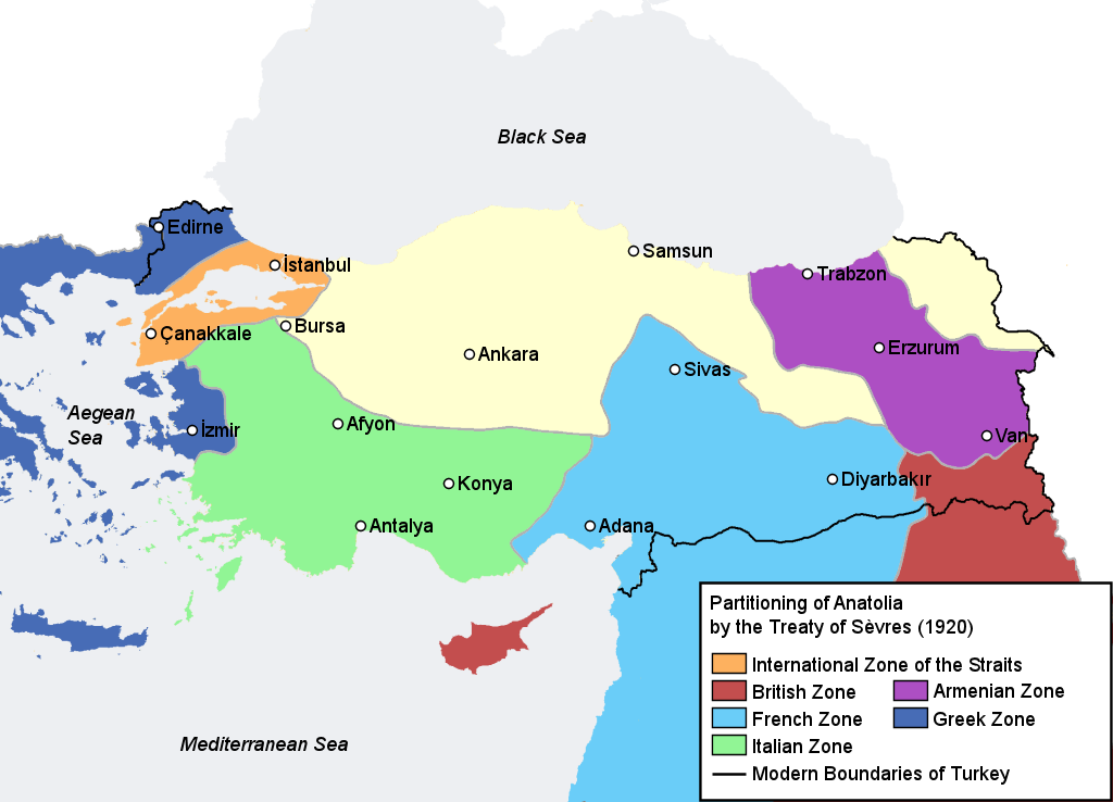
Partition of Ottoman Empire (Anatolia).png - Moodylo333

Armenia by the Sevres Treaty 1920.png - Ras67
WholeRegionSevres.gif - Zero0000

StraitsSevres.gif - Zero0000

ArmeniaSevres.gif - Zero0000

The President of The United States of America Woodrow Wilson Arbitration Decision Of Boundaries Between Armenia And Turkey.JPG - Khach Kavor

Treaty of Sevres , President Wilson Armenian Boundary 02.JPG - Khach Kavor

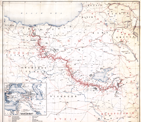
Boundary between Turkey and Armenia as determined by Woodrow Wilson.jpg - Chrishelenius

Armenians claims to Turkey according to the Treaty of Sevres, 1920.png - Super Dromaeosaurus
BlankMap-World-1920.png - Randomastwritter
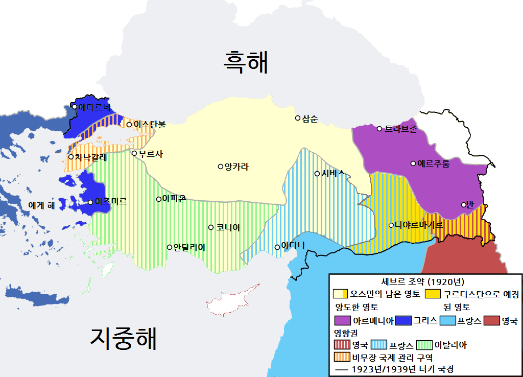
TreatyOfSevres-ko.png - 고려

Sevr Antlaşması.svg - Kalem

TreatyOfSevres-ko 1.svg - 고려
SevresOttoman1927.JPG - Infestor

TreatyOfSevres (corrected).ar.png - باسم

Treaty sevres otoman el.jpg - Wolfymoza

Sevres Treaty.jpg - RainbowMango

Χάρτης της Πρώτης Δημοκρατίας της Αρμενίας.jpg - LeB010

TratadoDeSèvres1920.svg - Rowanwindwhistler

Bestimmungen des Vertrag von Sèvres für ein unabhängiges Kurdistan (im Jahr 1920).png - Maxopos

,Bestimmungen des Vertrag von Sèvres für ein unabhängiges Kurdistan (im Jahr 1920).png - Maxopos
Treaty of Sèvres Middle East fr.png - Gundan
Boundary between Turkey and Armenia - as determined by Woodrow Wilson, president of the United States of America LOC 80695244.tif - Fæ

Boundary between Turkey and Armenia - as determined by Woodrow Wilson, president of the United States of America LOC 80695244.jpg - Fæ

TratadoDeSevres1920-pt.svg - Renato de Carvalho Ferreira

Treaty sevres otoman-hu.svg - Szajci

Treaty of Sèvres 1920.svg - GabagoolMuncher

Kurdistan1920-es.svg - Rowanwindwhistler

FR-WW1-1920-ar.png - باسم

The Treaty of Sèvres 1920.png - Luisao Araujo

The Treaty of Sèvres 1920 - English.png - Luisao Araujo

Sevr müqaviləsi 1920.jpg - Sura Shukurlu

The Treaty of Sèvres 1920 - Free version.png - Luisao Araujo

Sevr müqaviləsi - 1920.png - Luisao Araujo

SevresTreaty.png - Zero0000
Treaty of Sèvres &SovietRepublics of Transcaucasia.jpg - Kenech Kermian
Treaty of Sèvres &Soviet Republics of Transcaucasia.jpg - Labrang

TripartiteAgreement1920.jpg - Zero0000

Partition of Ottoman Empire Map.png - Visnelma

Treaty of Sèvres 1920-it.svg - PGS 1984

Turquie 1919-1921 d'après Luisao Araujo.png - ManuRoquette

Armenia Wilson Sevres treaty-Fr.png - Claude Zygiel

TreatyofSèvres1920.png - Ronnie Tang 221

Treaty of Sèvres 1920-ar.svg - Michel Bakni

The Treaty of Sèvres 1920 - EL.png - Flashdart2

Turkey location map with Wilsonian Armenia border.svg - Kaganer

Map of Sevres Treaty.png - Zemen

Chester Concessions 1923~.jpg - Armanum Luwian

Map of Great Greece (Megali Hellas) Venizelos c1920.jpg - Artanisen
Great Greece Map Claimed by Venizelos at Paris Peace Conference 1919.jpg - Artanisen

Map of Greater Greece (Greek Mandate, Zone of the Straits) Southeast Europe and Asia Minor 1922.jpg - Artanisen

Greater Greece Map Detail by John Bartholomew 1920.jpg - Artanisen

Greater Greece and Aegean Topographic Map by Bartholomew 1920.jpg - Artanisen

Balkan States and Greater Greece Map 1921 by Francis J Reynolds.png - Artanisen

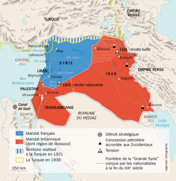
Syria - Sevres.png - DaSeashell