Wikimedi'Òc
Modes d'emploi

Cet album fait partie des albums
Cet album photos contient les sous-albums suivants :


Fertile Crescent map.png - Ras67

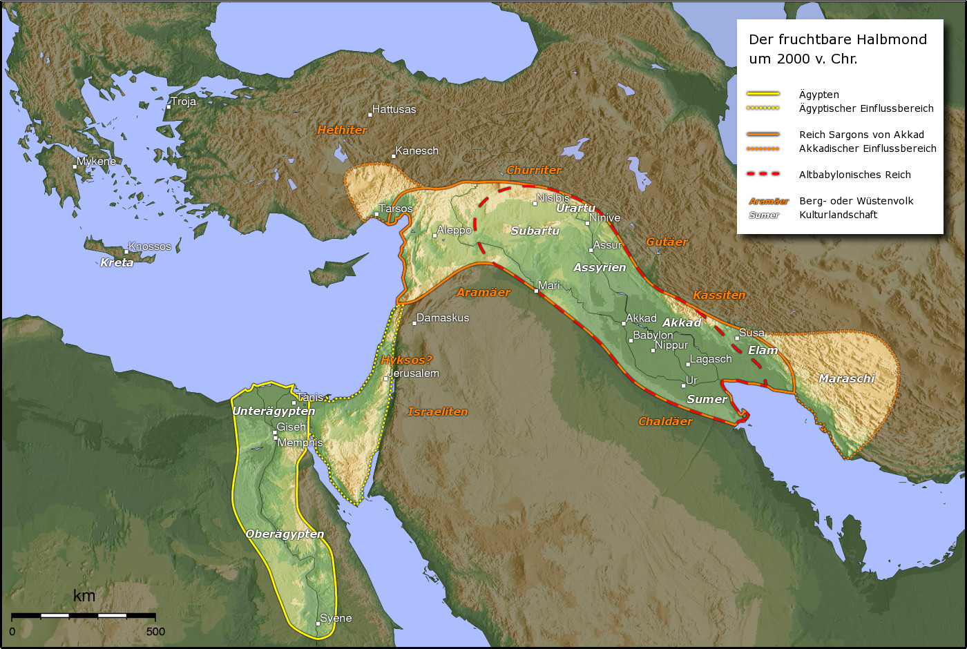
Fruchtbarer Halbmond.JPG - Maksim

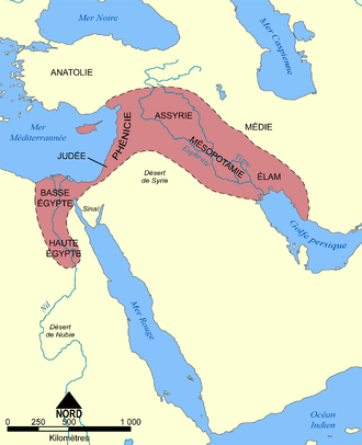
Croissant fertile carte.png - Sting
AlterOrient.jpg - Captain Blood~commonswiki
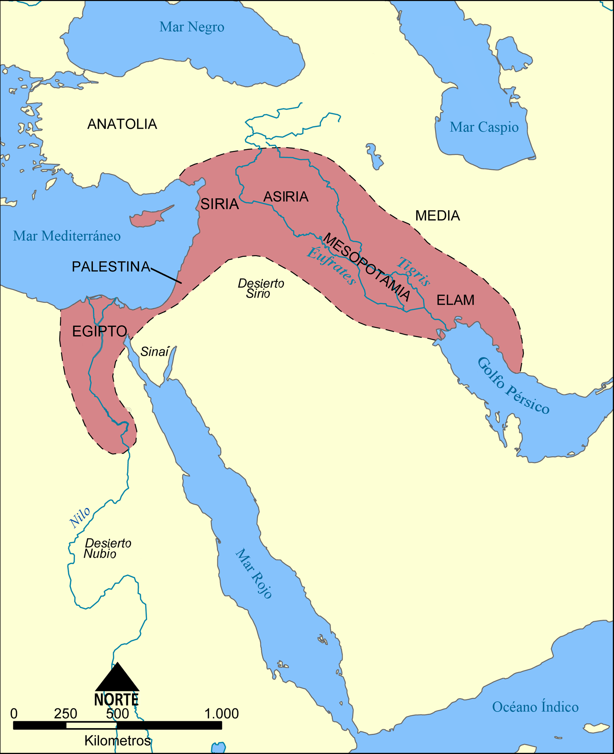
Mapa del Creciente Fértil.png - Locutus Borg

Vruchtbare sikkel.svg - Evil berry

Vruchtbare sikkel.PNG - Evil berry
Vruchtbare sikkel.JPG - File Upload Bot (Magnus Manske)

FertileCrescent11000BC.JPG - Bjoertvedt

Fertile Crescent 7500 BC.PNG - Iktsokh

Fertile Crescent 7500 BC Nor.PNG - Iktsokh
Fertile Crescent 7500 BC NOR.PNG - Iktsokh

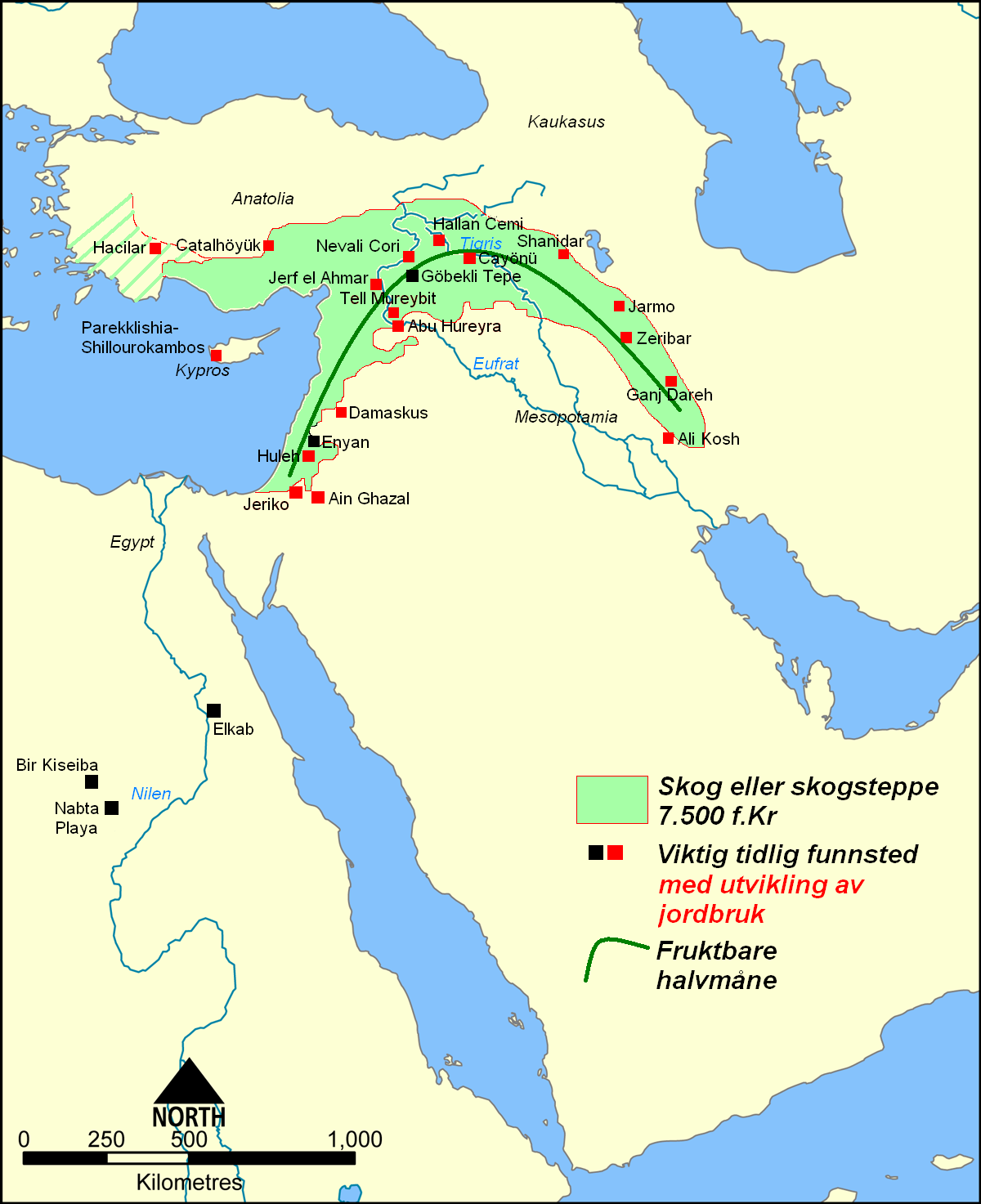
Fertile Crescent 7500 BC DAN.PNG - Iktsokh

C+B-Assyria-DetailedMap.JPG - Newman Luke
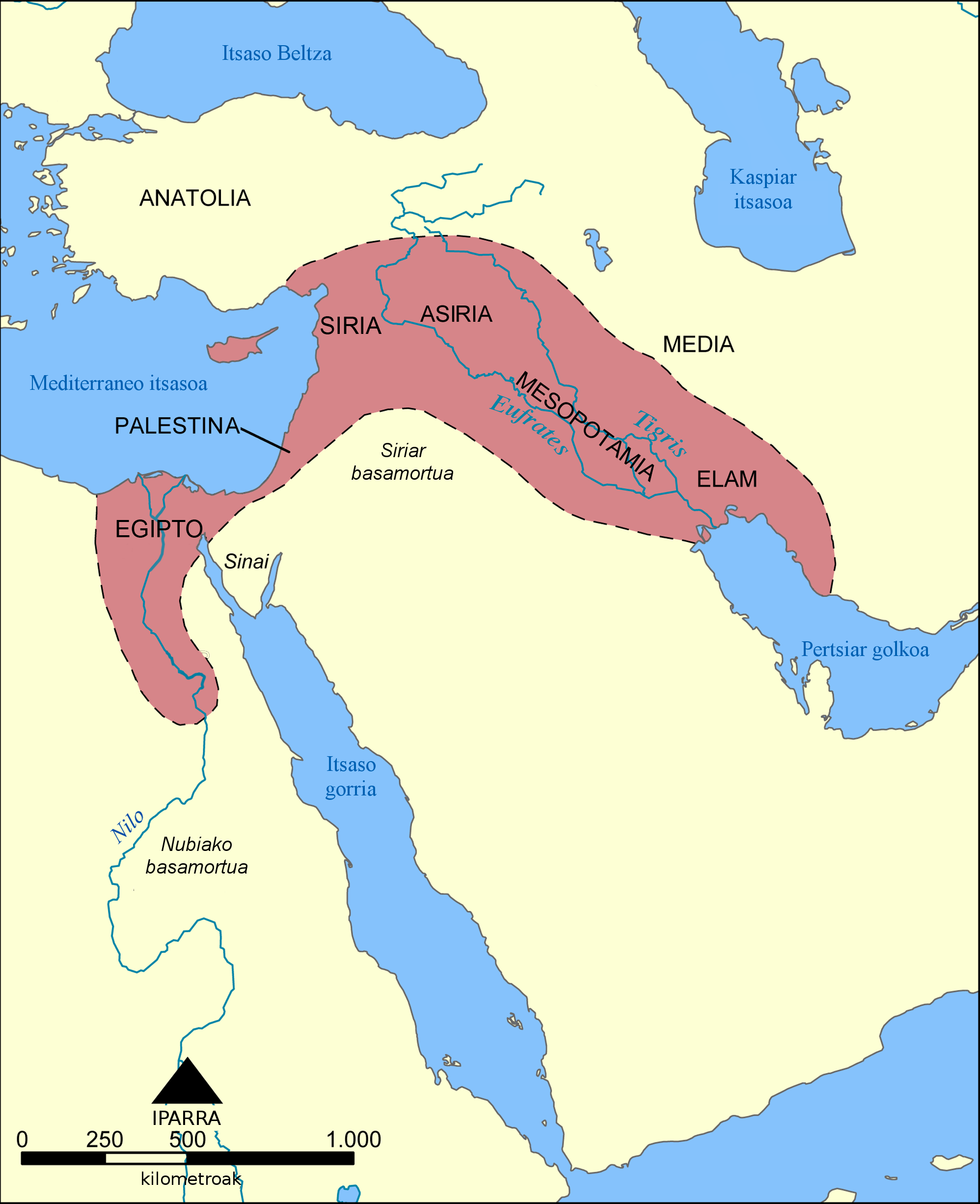
Ilgora Emankorraren mapa.png - Xabier Armendaritz

Fertile Crescent map rus.png - Midnight Stranger

Fertile Crescent.png - Hohum

Map of fertile crescent.svg - Nafsadh

Map of fertile cresent-sr.svg - BokicaK

Asirsko kraljestvo.PNG - Bostjan46

F Crescent.png - Iktsokh

Fertile Crescent map He.png - Amirki

Fertile Crescent map it.PNG - 92bari

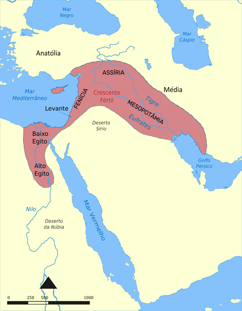
Mapa do Crecente Fertil en galego.png - JaviP96

Fruchtbarer Halbmond map deutsch.png - BMK

Map of fertile cresent-es.svg - Elvonudinium

Fertile Crescent concept 1916.png - Onceinawhile

Map of fertile crescent-ru.svg - Maxrossomachin

Mezzaluna fertile.png - Jumpjack2

Map of fertile cresent-tr.svg - Vanished User 1930800025

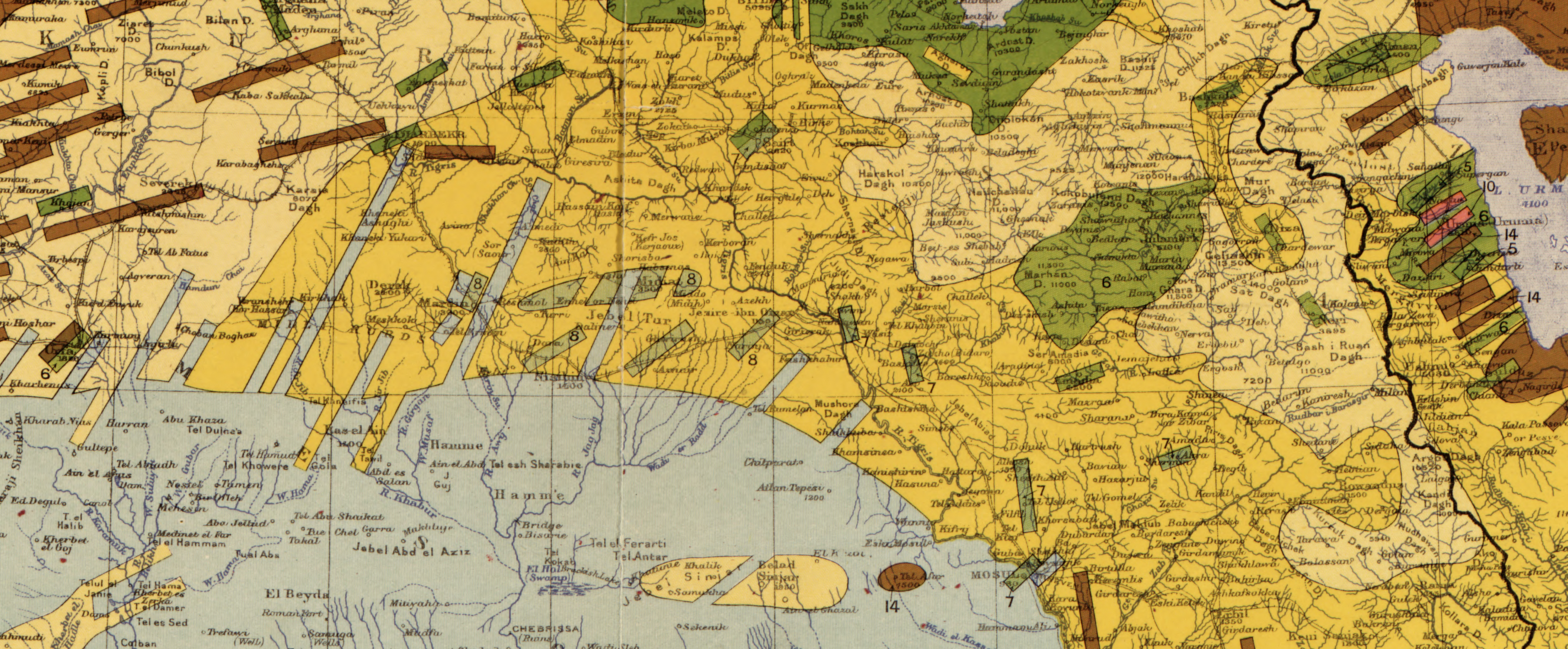
Maunsell's map, Pre-World War I British Ethnographical Map of eastern Turkey in Asia, Syria and western Persia 01.jpg - Onceinawhile

Fertile Crescent 7500 BC ARA.png - Iktsokh

Map of fertile crescent-ar.svg - باسم

Fertile crescent Neolithic B circa 7500 BC.jpg - Iktsokh

Hedelmällinen puolikuu.svg - Opetustuubi

Hedelmallinen puolikuu ja joistakin ensimmäisia asutuskeskuksia.svg - Opetustuubi

Neolithique ceramique PO.svg - Zunkir

Neolithique PO geo.svg - Zunkir

Fertile Crescent and Hilly Flanks.png - Joe Roe

Map of the Ancient Near East.jpg - Zoozaz1

Creixent Fèrtil.png - Gargotet

Map of fertile crescent-bxr.svg - Elvonudinium

Maunsell's map, Pre-World War I British Ethnographical Map of eastern Turkey in Asia, Syria and western Persia 01 (ethnographical key).jpg - GPinkerton

Maunsell's map, Pre-World War I British Ethnographical Map of eastern Turkey in Asia, Syria and western Persia 01 (toponymic key and scale).jpg - GPinkerton

Maunsell's map, Pre-World War I British Ethnographical Map of eastern Turkey in Asia, Syria and western Persia 01 (map key).jpg - GPinkerton

Maunsell's map, Pre-World War I British Ethnographical Map of eastern Turkey in Asia, Syria and western Persia 01 (ethnographical key – Russians).jpg - GPinkerton

Maunsell's map, Pre-World War I British Ethnographical Map of eastern Turkey in Asia, Syria and western Persia 01 (ethnographical key – Greeks).jpg - GPinkerton

Maunsell's map, Pre-World War I British Ethnographical Map of eastern Turkey in Asia, Syria and western Persia 01 (ethnographical key – Georgians and Lazes).jpg - GPinkerton

Maunsell's map, Pre-World War I British Ethnographical Map of eastern Turkey in Asia, Syria and western Persia 01 (ethnographical key – Armenians, Assyrians (Nestorians), Chaldaeans, and Jacobites).jpg - GPinkerton

Maunsell's map, Pre-World War I British Ethnographical Map of eastern Turkey in Asia, Syria and western Persia 01 (ethnographical key – Kurds).jpg - GPinkerton

Maunsell's map, Pre-World War I British Ethnographical Map of eastern Turkey in Asia, Syria and western Persia 01 (ethnographical key – Persians, Lurs, Tates, and Avshars).jpg - GPinkerton

Maunsell's map, Pre-World War I British Ethnographical Map of eastern Turkey in Asia, Syria and western Persia 01 (ethnographical key – Turkish-speaking peoples (excluding Lazes & Avshars)).jpg - GPinkerton

Maunsell's map, Pre-World War I British Ethnographical Map of eastern Turkey in Asia, Syria and western Persia 01 (ethnographical key – Arabs and Jews).jpg - GPinkerton

Maunsell's map, Pre-World War I British Ethnographical Map of eastern Turkey in Asia, Syria and western Persia 01 (ethnographical key – Circassians).jpg - GPinkerton

Maunsell's map, Pre-World War I British Ethnographical Map of eastern Turkey in Asia, Syria and western Persia 01 (ethnographical key – Lesghians).jpg - GPinkerton

Map of fertile crescent-pt.svg - Parzeus
Mapa da crescente fértil.png - Parzeus

Khalid ibn al-Walid's Desert March to Syria, ca. April 634.png - Al Ameer son
1910 map showing "Nestorians" (6), "Chaldeans" (7) and "Jacobites" (8), in Maunsell's map, Pre-World War I British Ethnographical Map of eastern Turkey in Asia, Syria and western Persia 01 (cropped).jpg - Onceinawhile

BC1781 Mesopotamia map.png - TEN

Map of fertile crescent lv.svg - Kikos

Map of fertile crescent-af.svg - Pynappel

Map of fertile crescent-ca.svg - Manlleus

Choga mami on near east precipitation map 1.png - Merikanto

Early agriculture sites in near east 1.png - Merikanto

Early agriculture sites in near east 2.png - Merikanto

Fertile crescent precipitation 1.png - Merikanto

Fertile crescent precipitation 2.png - Merikanto

January Temperature Middle East 1.png - Merikanto

July Temperature Middle East 1.png - Merikanto

January Rain Middle East 1.png - Merikanto

July Rain Middle East 1.png - Merikanto

Neolithic and chalcholithic sites in near east 1 1.png - Merikanto

Fertile crescent neolithic sites 2 1.png - Merikanto

Simple estimation of hunter gatherer population of ancient near east from rainfall and land wetness estimation 17000 bp 1.png - Merikanto

Koeppen climates of near east and some neolithic archaeological sites 1.png - Merikanto

Near east winter rain areas and some early neolithic sites 1.png - Merikanto