Wikimedi'Òc
Modes d'emploi

Cet album fait partie des albums
Cet album photos contient les sous-albums suivants :


Delaware and Chesapeake Bays satellite image.jpg - Edbrown05~commonswiki

Map of territorial growth 1775.jpg - Ras67

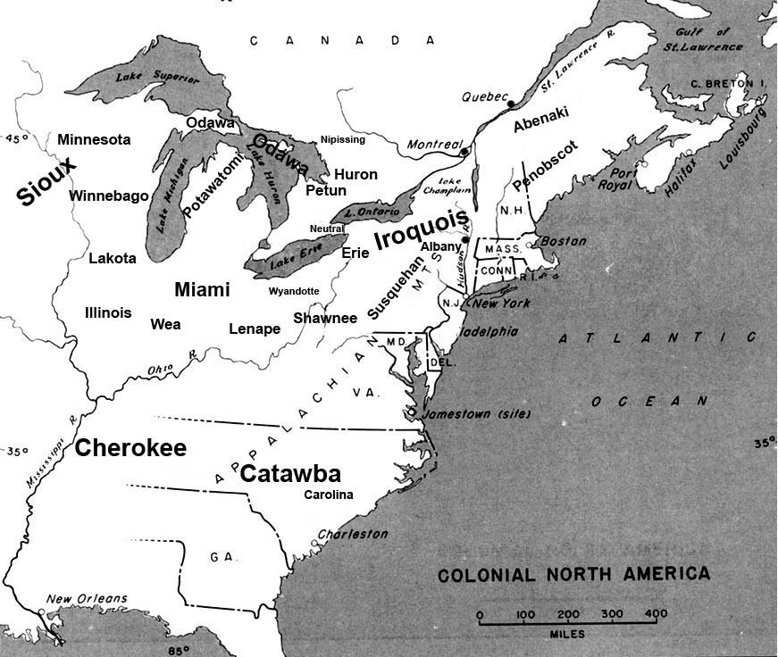
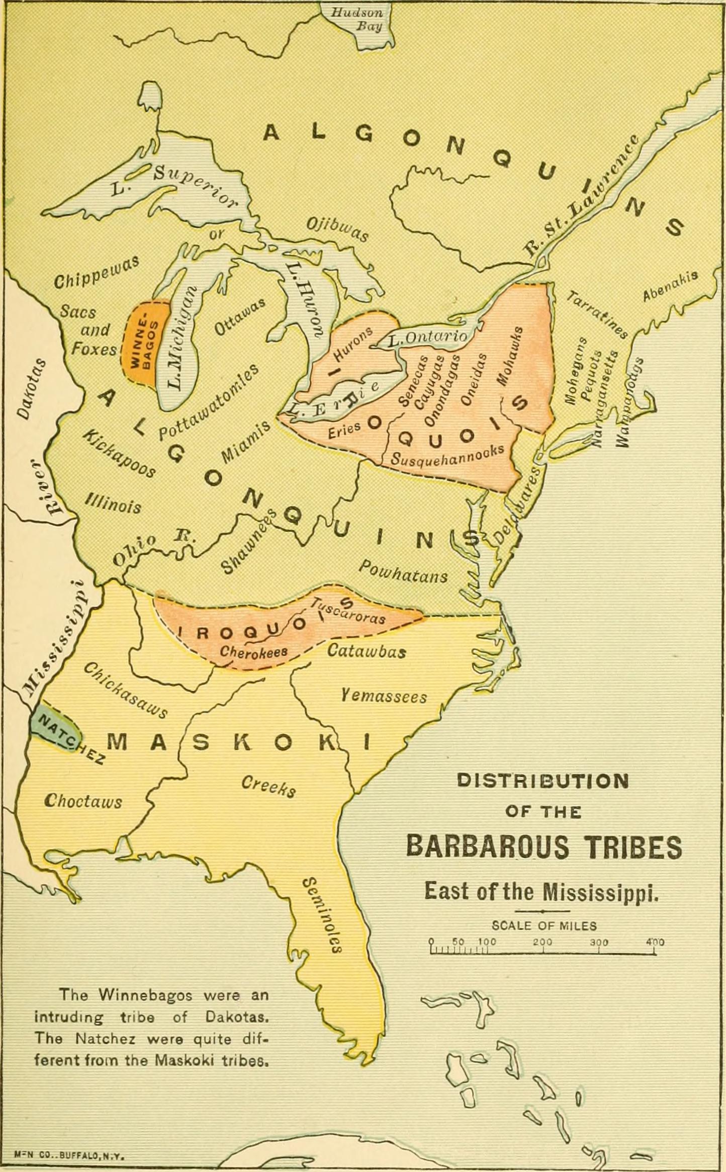
Early indian east.jpg - Walden69

US east coast middle appalachian physio map.jpg - Urban~commonswiki

Brunswick in the USA.jpg - JA ALT
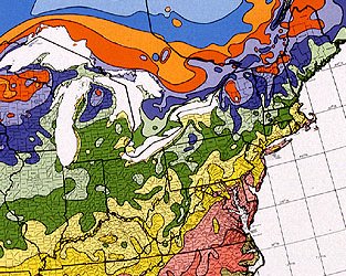
USDA Hardiness zone map detail for northeast US.jpg - SB Johnny

HollandinVSA.png - SieBot

US map-East Coast.png - Nikopoley
Eastern US range map blank.png - Alan Rockefeller

HollandAmerica.png - Rottweiler

Ran clam NA range.gif - File Upload Bot (Magnus Manske)

USA oral vaccination.jpg - Izvora
BlankMap-USA-Northeast.svg - Shereth
Beaver wars map.jpg - Charles Edward

US East Temples Outline Map.svg - Shereth

Indiana Bat Range FWS.jpg - ZeWrestler

Map of the United States of America 1845.jpg - Geo Swan

Skywave Effect of AM.png - Mrgoogfan
Magnolia grandiflora map.png - GreenZmiy

1848 Phelps National Map of the United States (pocket map) - Geographicus - UnitedStates-phelps-1848.jpg - BotMultichillT

US map-East Coast.svg - Southronite

Carolinas.svg - Derfel73

Liquidambar styraciflua map.png - Ebe123

LLWS Mid-Atlantic.svg - Renschi81

LLWS East.svg - Renschi81

NASA Eyes Declining Vegetation in the Eastern United States from 2000 to 2010.jpg - Stas1995

Maury Geography 051A Middle Atlantic.jpg - Keith Edkins

Lenape Languages.png - TheLateDentarthurdent
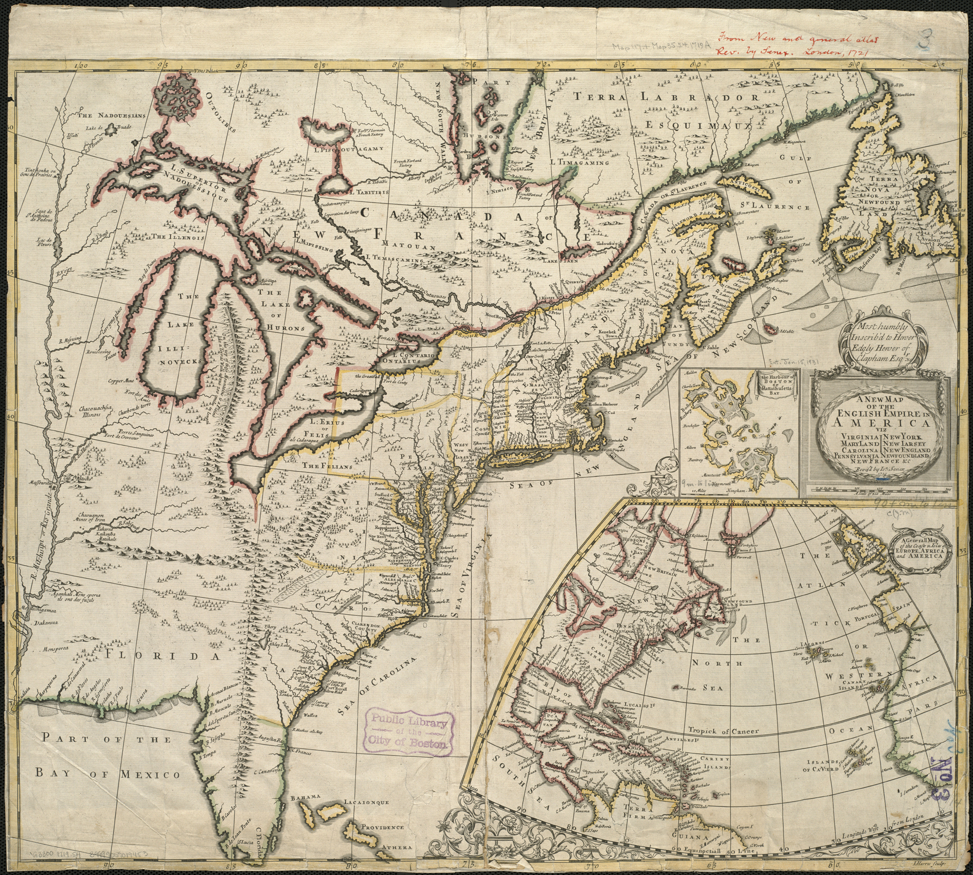
A new map of the English empire in America viz. Virginia, Maryland, Carolina, Pennsylvania, New York, New Iarsey, New England, Newfoundland, New France &c. (4071882051).jpg - File Upload Bot (Magnus Manske)
A chart of the coast of America - from New York and Philadelphia to the Strait or Gulf of Florida, and from thence to the Mississippi - a new edition corrected and improved by J.W. Norie, NYPL434117.tiff - Fæ

A chart of the coast of America - from New York and Philadelphia to the Strait or Gulf of Florida, and from thence to the Mississippi - a new edition corrected and improved by J.W. Norie, NYPL434117.jpg - Fæ
The travellers guide, or, Map of the roads, canals and rail roads of the United States, with the distances from place to place - by H.S. Tanner. NYPL434057.tiff - Enyavar

Delaware river watershed.png - GifTagger

Eastern agricultural complex.png - Smallchief

Report of the New Jersey commissioners on the Centennial Exhibition. (1877) (14589722828).jpg - Fæ
A history of the United States for schools (1899) (14779003632).jpg - Fæ

Indian history for young folks (1919) (14566585870).jpg - Fæ

The Southern states of North America- a record of journeys in Louisiana, Texas, the Indian territory, Missouri, Arkansas, Mississippi, Alabama, Georgia, Florida, South Carolina, North Carolina, (14761473604).jpg - Fæ

Fifth Lighthouse District ppmsca.09354.jpg - Holly Cheng

Map of USA highlighting Eastern Seaboard.png - Kingofthedead

East Region (WFTDA).png - Kingofthedead
Potomac Highlands WVA.jpg - Kingofthedead

Native Tribes 1783.jpg - Captain Thor

Adirondacks-fr.jpg - YanikB

1799 Cruttwell Map of the United States of America - Geographicus - UnitedStates-cruttwell-1799.jpg - BotMultichillT

The Mid-Atlantic States.png - Estshr

FDIC Mid-Atlantic Region.jpg - 007bond

Aircraft flight path from NC to GA, running near the local VORTAC stations.png - ВоенТех

187 of 'A School History of the United States ... Being a revision and rewriting of Swinton's "Condensed School History of the United States."' (11128327013).jpg - Artix Kreiger 2
102 of 'A History of the United States for schools ... With topical analysis, suggestive questions ... by F. A. Hill. (With maps.)' (11304456984).jpg - Artix Kreiger 2
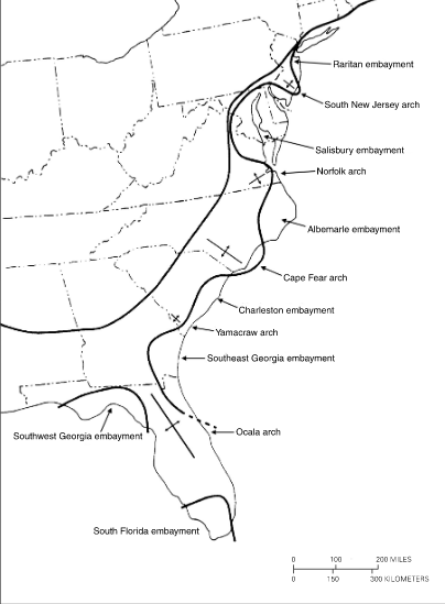
Basins and arches of the Atlantic Coastal Plain.png - Qtz arenite

Middle Atlantic States.jpg - Dubyavee

Map Exhibiting the position of the Lands occupied by Indian Tribes in Amity with the United States- and also The Lands Ceded to the United States, by Treaty with various Indian Tribes. - United States o(...) - NARA - 102278691 (page 3).jpg - US National Archives bot

Colonial Pipeline Disruption U.S. East Coast (29877529455).png - Ser Amantio di Nicolao

Map of the American East.jpg - Zoozaz1
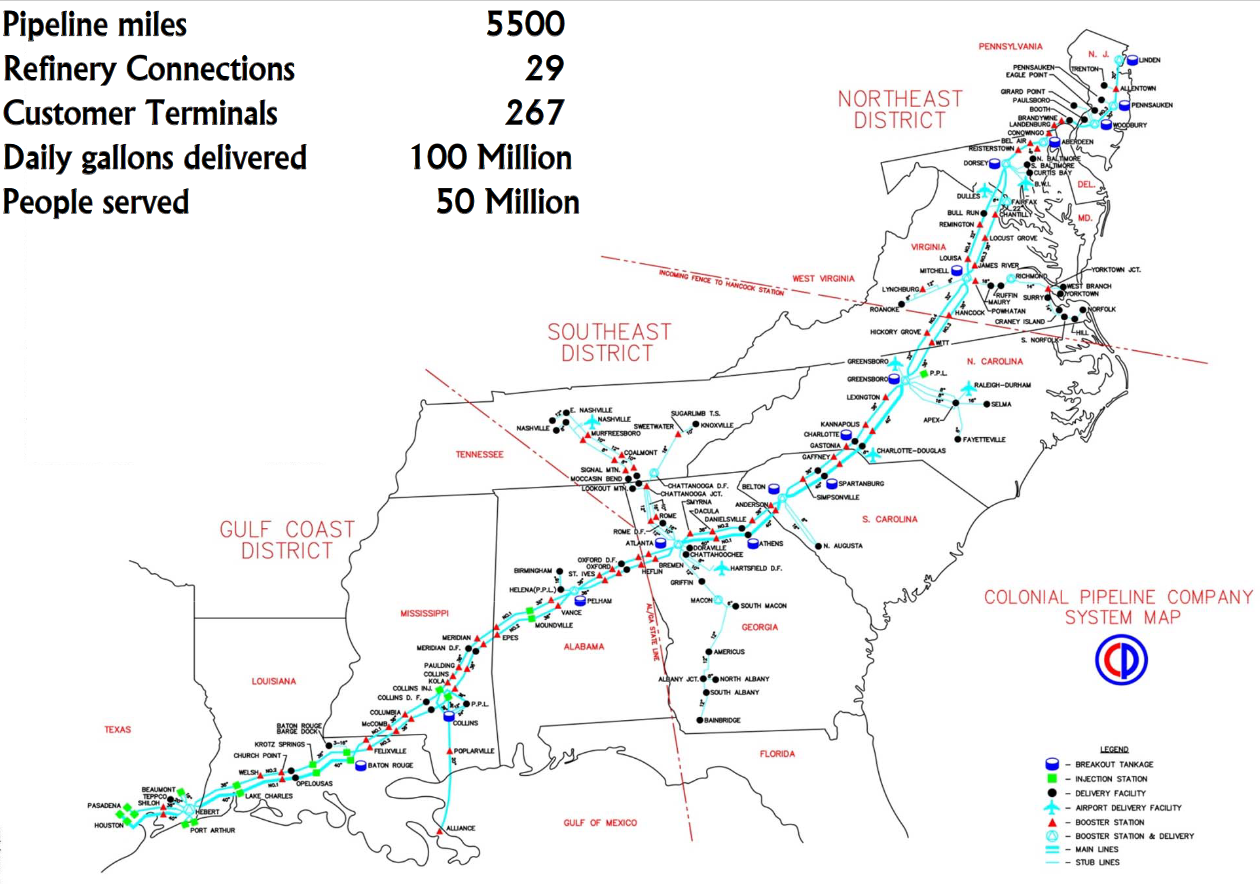
Colonial Pipeline System.png - L'amateur d'aéroplanes

PAT - Eastern United States.gif - Babelia

Symphyotrichum racemosum distribution.jpg - Eewilson

Map of the United States of America by H. S. Tanner, 1832, Third Edition - DPLA - fc31bb35139021971014eec35d6327d1 (page 1).jpg - DPLA bot

Mitchell's traveler's guide through the United States, containing the principal cities, towns &c. alphabetically arranged; together with the steam-boat, canal, and railroad routes, - DPLA - d815861cf5f6d8dfb727ffd9026cb74d (page 2).jpg - DPLA bot

Mitchell's traveler's guide through the United States, containing the principal cities, towns &c. alphabetically arranged; together with the steam-boat, canal, and railroad routes, - DPLA - d815861cf5f6d8dfb727ffd9026cb74d (page 3).jpg - DPLA bot

NortheastAppalachiansMap.gif - Hike395

Admiralty Chart No 2710 Delaware Bay to Florida Strait, published 1924, Large Corrections 1933.jpg - Kognos

Eastern United States Map.jpg - PhilDaBirdMan

Spatial distribution of VLM across the US Atlantic coast.webp - Prototyperspective

US Atlantic States.svg - Sbb1413