Wikimedi'Òc
Modes d'emploi

Cet album fait partie des albums
Cet album photos contient les sous-albums suivants :

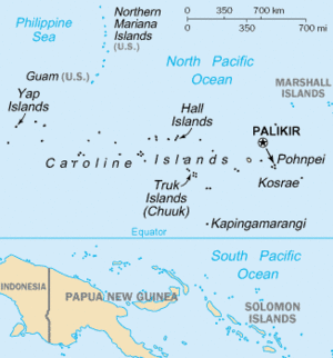


Map of the Federated States of Micronesia CIA.jpg - Ras67

Caroline Islands-map.gif - Ras67
LocationCarolineIslands.png - Ras67

114 karolinen-marshall-marianen-und-palau-inseln (1905).png - 14nu5

Bistum Karolinen.png - Chumwa

Atoll research bulletin (1956) (20346018755).jpg - SteinsplitterBot

Atoll research bulletin (1956) (20337516272).jpg - SteinsplitterBot

Atoll research bulletin (1956) (20319844246).jpg - Fæ

Atoll research bulletin (1956) (20319743826).jpg - SteinsplitterBot

A voyage of discovery into the South Sea and Beering's (sic) Straits, for the purpose of exploring a north-east passage (microform) - undertaken in the years 1815-1818, at the expense of His Highness (20442490628).jpg - SteinsplitterBot

FMIB 53148 Ravins des Caroplines et des Mariannes, d'apres la Carte generale bathymetrique des oceans.jpeg - BMacZeroBot

Lettres edifiantes et curieuses ecrites des missions etrangeres parquelques missionnaires de la comp compagnie de Jesus (1707) (14578378369).jpg - Fæ
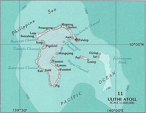
Ulithi Atoll.jpg - Mauerquadrant

Kusaie (Kosrae).jpg - Mauerquadrant

638 of 'Manual of Geology- treating of the principles of the science with special reference to American geological history ... Revised edition' (11047414163).jpg - Artix Kreiger 2

636 of '(Manual of Geology- treating of the principles of the science with special reference to American geological history ... Revised edition.)' (11078314856).jpg - Artix Kreiger 2

14 of 'Pacific Islands ... Sailing Directions ... Compiled from various sources (by G. E. Richards)' (11174632224).jpg - FlickreviewR 2

18 of 'Pacific Islands. vol. I. Western Groups. Sailing Directions, etc. (Second edition. Revised and enlarged by W. Tooker.) (Supplement, 1894.)' (11202573433).jpg - Artix Kreiger 2

Admiralty Chart No 764 Caroline Islands eastern portion, Published 1930, Large Corrections 1960.jpg - Kognos

Admiralty Chart Catalogue 1967 Page 084 Index O.jpg - Kognos

Track of the Albatross from Pohnpei through the Caroline Islands to Guam in February 1900 (map0027541873).jpg - Featous

The Philippine Sea.jpg - Zoozaz1

Adelbert von Chamisso - map of the Caroline Islands.jpg - Polarlys

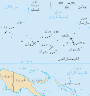
Caroline Islands-map-ar.gif - Sgh45

Admiralty Chart No 909 Islands and Anchorages in the Caroline Islands, Published 1929.jpg - Kognos

Admiralty Chart No 978 Islands and Anchorages in the Caroline Islands, Published 1929.jpg - Kognos

Admiralty Chart No 970 Islands and Anchorages in the Caroline Islands, Published 1929.jpg - Kognos

Admiralty Chart No 763 Caroline Islands Western Portion, Published 1930.jpg - Kognos

Admiralty Chart No 980 Caroline Islands, Published 1872, New Edition 1912.jpg - Kognos

Admiralty Chart No 977 Islands and Anchorages in the Caroline Islands, Published 1928.jpg - Kognos