Wikimedi'Òc
Modes d'emploi

Cet album fait partie des albums
Cet album photos contient les sous-albums suivants :


Reich des Mithridates aus-Putzgers, Historischer Schul-Atlas 39. Auflage. 1917. Tafel 9a.jpg - Elias84

Map Anatolia-fr draft.svg - Bibi Saint-Pol

Asia minor p20.jpg - OgreBot

Asiaminorhistory.jpg - File Upload Bot (Magnus Manske)

Anatolian peoples in 1st millennium BC.jpg - Castagna

Roman East 50-en.svg - ԱշոտՏՆՂ

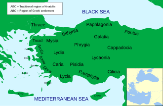
Map Anatolia ancient regions-en.svg - FrozenCourgette

Political map of Asia Minor in 500 BC in Masry.PNG - Ramsis II

Carte Carie-he.png - רוליג

Roman East 50-it.svg - DaniDF1995

C+B-Galatia-Map.JPG - Newman Luke
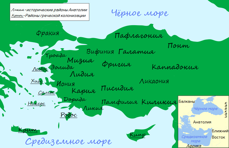
Map Anatolia ancient regions-ru.png - V4711
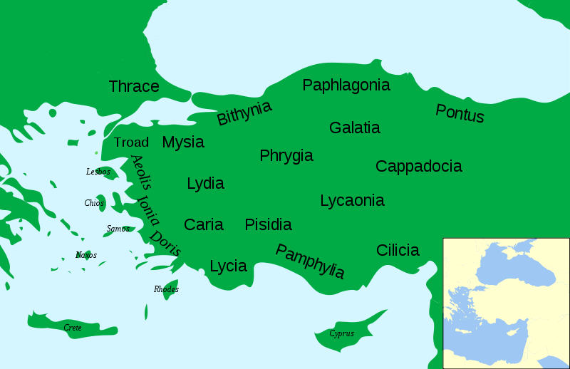
AnatoliaAncientRegions.png - Labberté K.J.

Map Anatolia ancient regions-el.svg - Egmontaz

Hattic-language-rus.png - Koryakov Yuri

Map Anatolia ancient regions-pt.svg - Richard Melo da Silva

Asia minor-Shepherd 1923.JPG - File Upload Bot (Magnus Manske)

Classical antiquity historical territory of Minor Asia (ru).jpg - File Upload Bot (Magnus Manske)

Brue, Adrien Hubert, Asie-Mineure, Armenie, Syrie, Mesopotamie, Caucase. 1839. (E).jpg - Geagea

Brue, Adrien Hubert, Asie-Mineure, Armenie, Syrie, Mesopotamie, Caucase. 1839. (EC).jpg - Geagea

Brue, Adrien Hubert, Asie-Mineure, Armenie, Syrie, Mesopotamie, Caucase. 1839. (H).jpg - Geagea

Antoine Philippe Houze. L'Empire des Perses. 1844 (D).jpg - Geagea

Robert de Vaugondy. Map of the Early Ages of the World. 1762.jpg - Quibik

Roman East 50-fi.svg - Barosaurus Lentus
Location of Isauria-Asia Minor Map, Classical Atlas, 1886, Keith Johnston.jpg - Polylerus

Ancient edremit gulf.jpg - Ollios
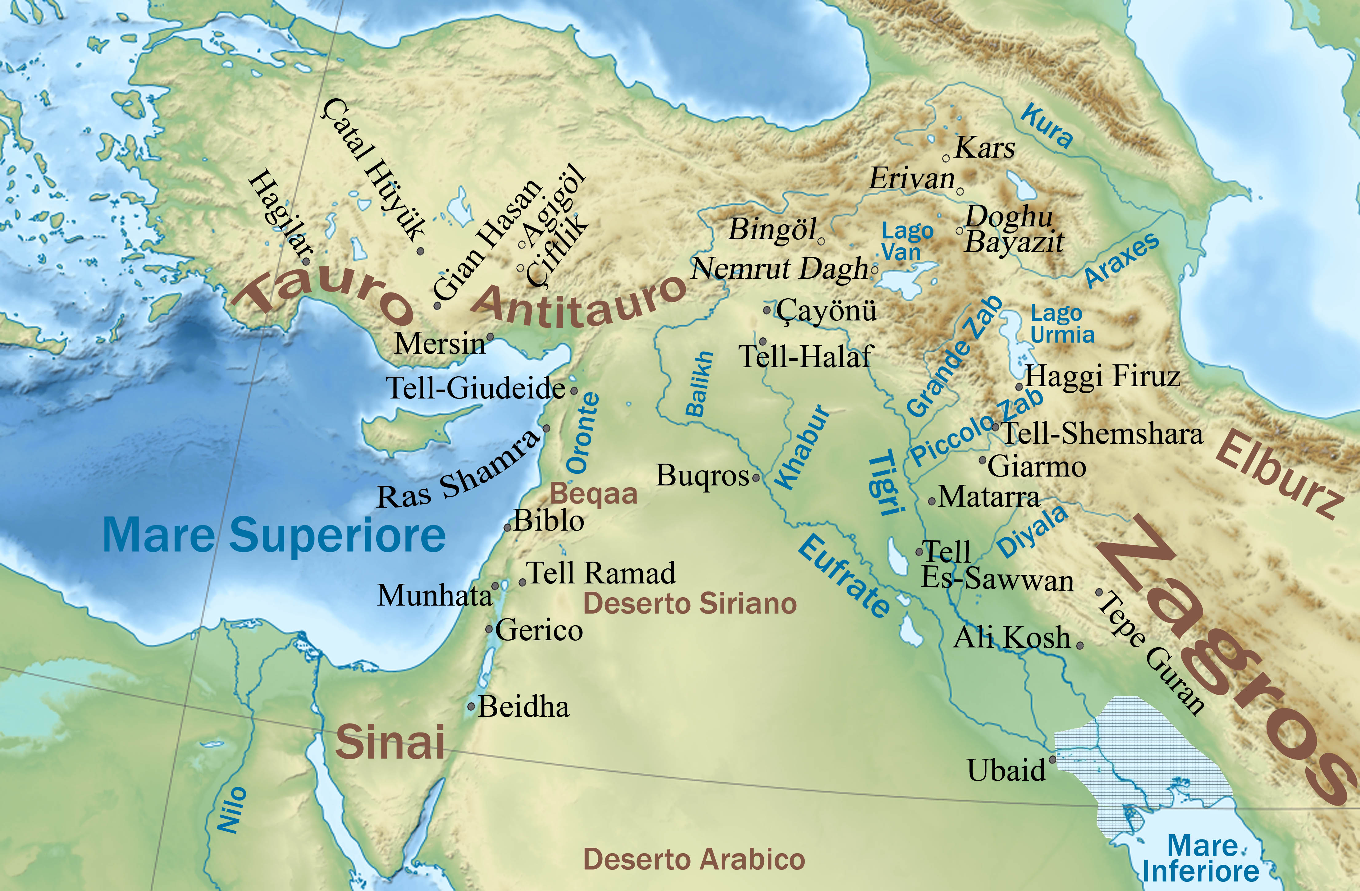
Siti neolitici del Vicino Oriente.jpg - Pequod76

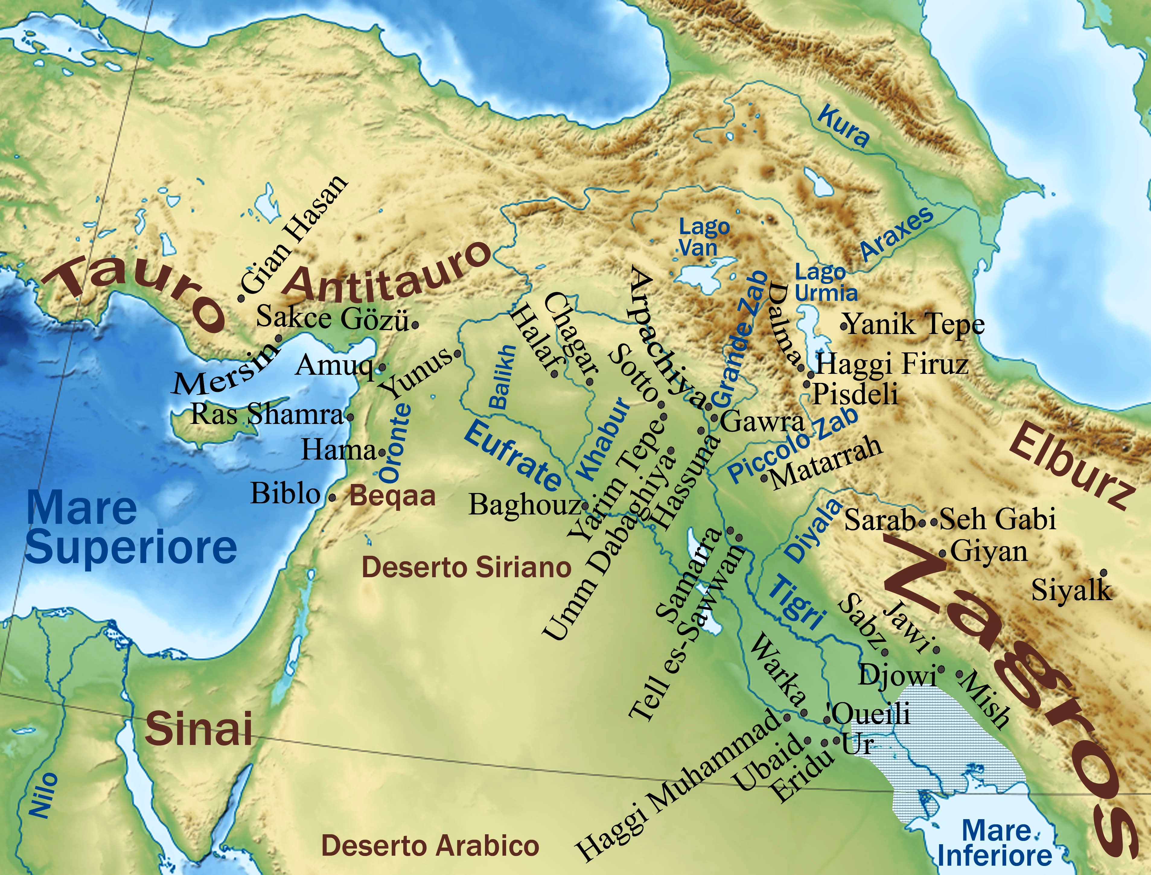
Culture ceramiche del Vicino Oriente nel medio Halaf - 5200-4500 a.C.jpg - Pequod76
Neolitico ceramico, calcolitico e bronzo antico nel Vicino Oriente.jpg - Pequod76

Lycia locator map.svg - Spinningspark

Elaioussa-Sebaste.JPG - File Upload Bot (Magnus Manske)

LangThraco-Illyri.png - Spiridon Ion Cepleanu

Map Anatolia ancient regions-hu.svg - Szajci
Carte Lycaonie.png - Spiridon Ion Cepleanu
Carte Paphlagonie.png - Spiridon Ion Cepleanu

Carte Isaurie.png - Spiridon Ion Cepleanu

Carte Pisidie.png - Spiridon Ion Cepleanu

Anatolia 264.jpg - Michael Goodyear

Ancient Anatolia nor.png - Finn Bjørklid

Map Anatolia ancient regions-af.jpg - BurgertB

Antic Anatolia.jpg - Julieta39

Heinrich Kiepert. Asia citerior.Lycaonia.jpg - Geagea

Luwiya.svg - Al-qamar
Middle East topographic map-blank 3000bc crop.svg - File Upload Bot (Magnus Manske)

Near East topographic map with toponyms 3000bc.svg - Fulvio314

Roman East 50-pt.svg - Renato de Carvalho Ferreira

Antikamindreasien.png - FBQ

Map Anatolia ancient regions-uk.svg - Mykola Swarnyk
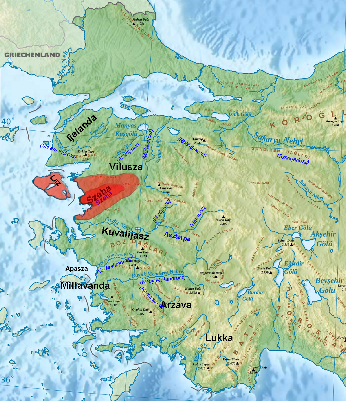
Szeha.jpg - Regasterios

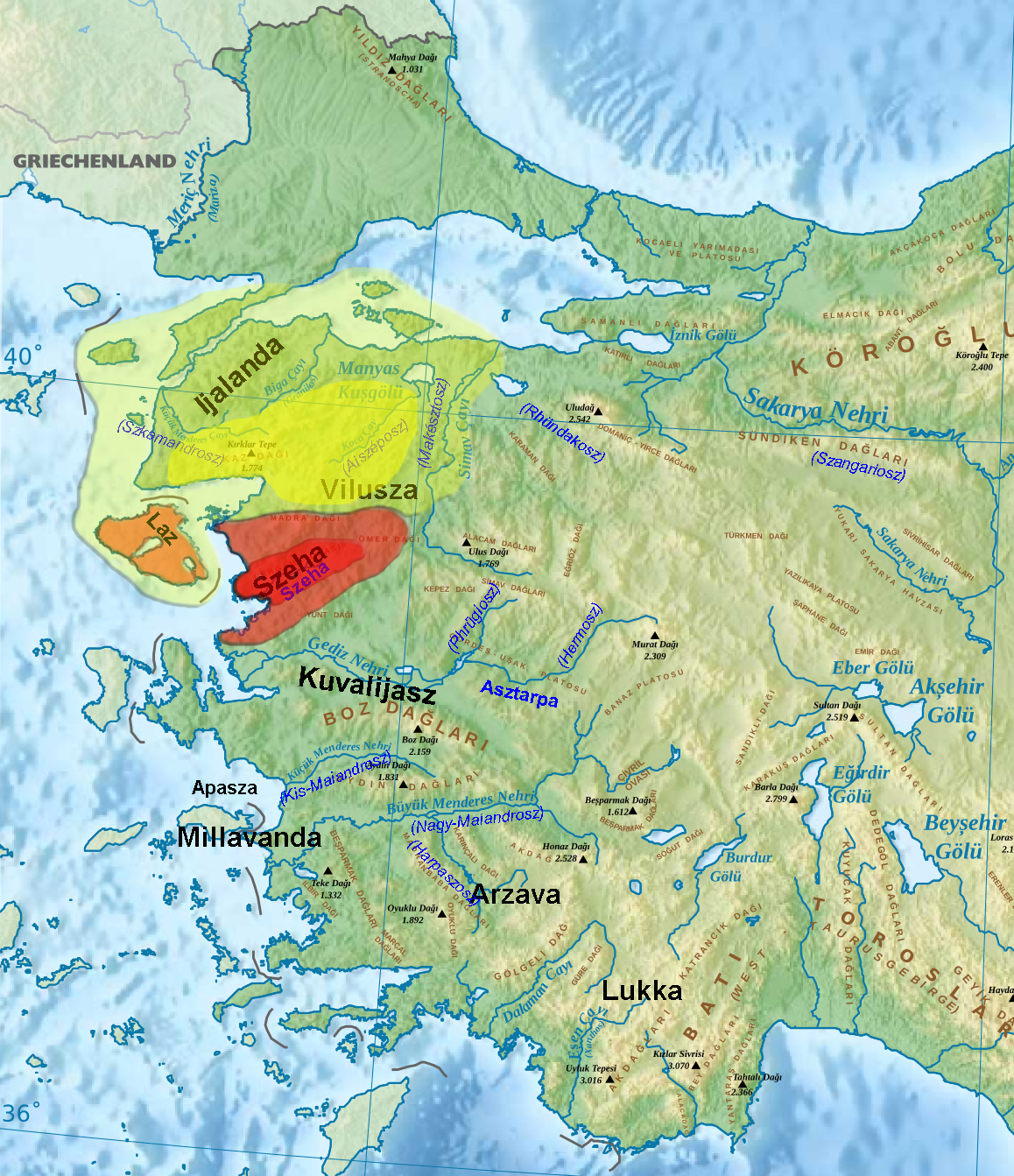
Térkép Tudhalijasz és Arnuvandasz koráról.png - Regasterios

Anatólia nyári legelői.png - Regasterios
Vilusza.jpg - Regasterios

Map of Roman dependency of Sophene, Corduene, Commagene, and Osrhoene as of 31 BC.png - WikiEditor2004

Roman East 50-es.svg - Rowanwindwhistler

Af Western Asia Minor Greek Colonization af.svg - Wawiel

Roman East 50-ang.svg - Hogweard

Carte Bithynie.png - Spiridon Ion Cepleanu

RegionesDeAsiaMenor.svg - Rowanwindwhistler

Map Anatolia ancient regions-es.svg - Rowanwindwhistler

Roman East 50 CE Commagene highlighted-en.svg - QuartierLatin1968

Map Anatolia ancient regions-it.svg - Dr Zimbu

Roman East 50-he.svg - Geagea

Map of Greece, Archipelago and part of Anadoli; Louis Stanislas d'Arcy Delarochette 1791.jpg - HerrAdams

Near East topographic map with toponyms 3000bc-pt.svg - Renato de Carvalho Ferreira

Carte Isaurie-es.svg - Rowanwindwhistler

Asia Minor in the Greco-Roman period - general map - regions and main settlements - bleached - English legend.jpg - Caliniuc
Asia Minor in the Greco-Roman period - general map - regions and main settlements.jpg - Caliniuc

Roman East 50-hu.svg - Szajci

Arzawa be.png - Frantishak

مناطق آناتولی باستان.svg - Surena

Alter Orient 1900BC.svg - Enyavar

Alter Orient 1800BC.svg - Enyavar

Alter Orient 2000BC.svg - Enyavar

Alter Orient 2100BC.svg - Enyavar

Alter Orient 2200BC.svg - Enyavar

Alter Orient 2300BC.svg - Enyavar

Map Anatolia ancient regions-tr.svg - Vanished User 1930800025

Map Anatolia ancient regions-zh.svg - Vikarna

Roman East 50-zh.svg - Vikarna

Roman East 50 CE Commagene highlighted-zh.svg - Vikarna

Map of the Ancient Near East.jpg - Zoozaz1

Anatòlia Edat de Bronze.png - Gargotet

Ancient Near East 2300BC.svg - Enyavar

Ancient Near East 2200BC.svg - Enyavar

Ancient Near East 2000BC.svg - Enyavar

Ancient Near East 1900BC.svg - Enyavar

Ancient Near East 1800BC.svg - Enyavar

Map Anatolia ancient regions-sl.svg - A09

Map Anatolia ancient regions (Indonesian version).svg - Ivan Humphrey

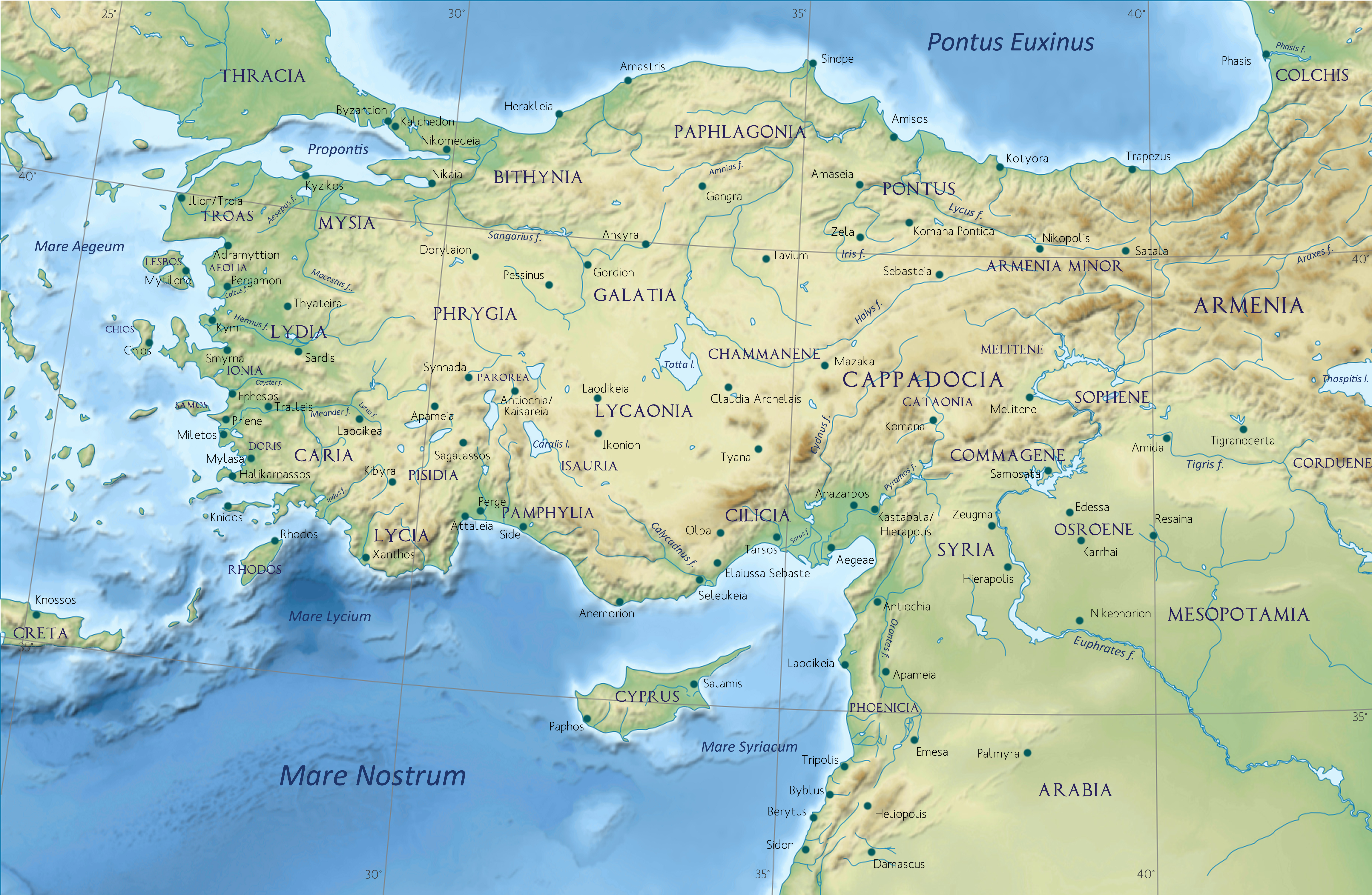
Asia Minor - Armenia Minor.jpg - Yerevantsi

Мисия Лидия Кария Ликия Иония.png - Пётр Тарасьев

Харран (2).svg - Удивленный1

Carte Pamphylie.png - Claude Zygiel

Asia Minor in the Greco-Roman period - general map - regions and main settlements (cropped).jpg - Magnum5051
Anatolia Ancient Regions ID.png - JohnThorne
Greece, Archipelago and Part of Anadoli - By L. S. de la Rochette, MDCCXC ; W. Palmer sculp. - btv1b530996134.jpg - Gzen92Bot

L'Asie mineure et le Bosphore pour l'histoire ancienne de Mr. Rollin - par le Sr d'Anville ; Gravée par P. Bourgoin - btv1b53179406z (1 of 2).jpg - Gzen92Bot

L'Asie mineure et le Bosphore pour l'histoire ancienne de Mr. Rollin - par le Sr d'Anville ; Gravée par P. Bourgoin - btv1b5963956q.jpg - Gzen92Bot

Map Anatolia ancient regions-ru.svg - Пётр Тарасьев

Luvianoj.svg - ThomasPusch

Reiaume de Pònt durant lo rèine de Mitridat VI.png - Nicolas Eynaud

Kingdom of Pergamon.png - Ennomus

Empire of the Hitties.png - Ennomus

Bithynian Kingdom.png - Ennomus

Kingdom of Cappadocia.png - Ennomus

Asia Minor in the Greco-Roman period-zh.svg - Vikarna

Map Anatolia-ca.svg - Manlleus

Map Anatolia ancient regions-grc.svg - Anaxicrates