Wikimedi'Òc
Modes d'emploi

Cet album fait partie des albums
Cet album photos contient les sous-albums suivants :


Cmentarz Wojenny w Kołobrzegu (1).JPG - Dedal
Matapan map.png - Ras67

CapeEsperanceChart1.jpg - Hohum

Saint Nazaire Harbour 1942.png - CorbeilCommon
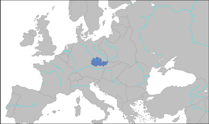
ProtectoradoBohemiaMoravia.PNG - Dove

Karte curzonlinie.png - PolarBot

Luftangriffe auf Dresden.png - Palitzsch250
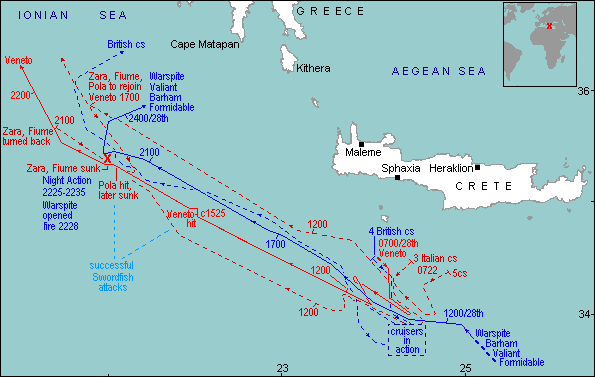
Battle of Cape Matapan map.gif - Liandrei

Central pacific wwII.jpg - Bwmoll3
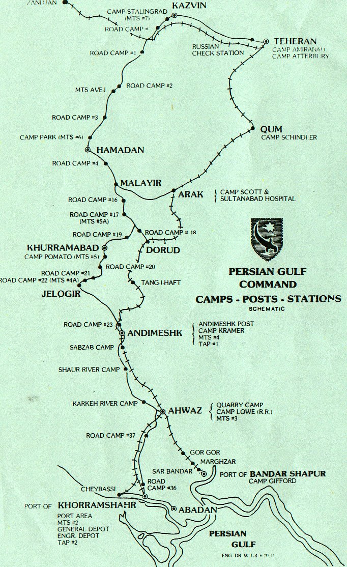
PersianGulfCommand.jpg - Wvk
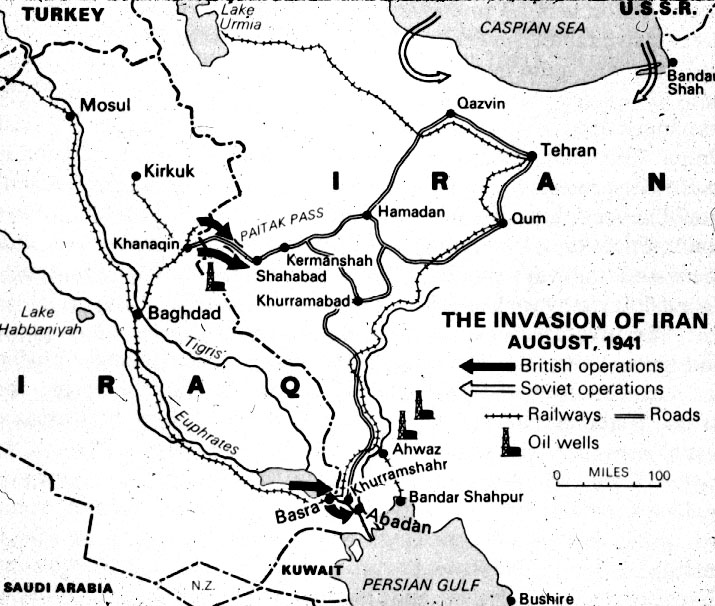
InvasionIran1941.jpg - Wvk
Guadalcanal11m.png - Pibwl

Saint Nazaire Harbour 1942 PL.png - Chrzanko

Objectifs.jpg - Mirage2000D

Bolero route.jpg - MGA73bot
WWII-Mediterranean-v1.PNG - OgreBot

Arctic convoys.png - Matanya
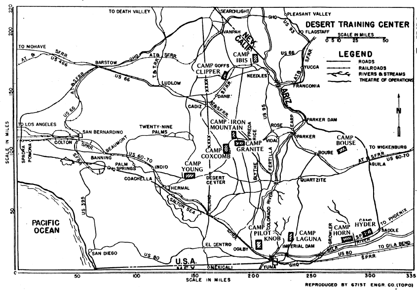
Desert training center - map.png - Bwmoll3
Operation frantic map.png - SamOdin
Rschew Operation Bueffelbewegung.png - Graf zu Pappenheim

Map of World War II Japanese American internment camps.png - Ras67
Military administration Belgium Northern France.png - Victor falk~commonswiki

Map Of Driant.jpg - Molestash
22c196 Map1.jpg - WebMining 296

Clinton Engineer Works.png - Liandrei

Hanford Engineer Works.png - Liandrei

Greater Asian Co-prosperity sphere.png - TheNavigatrr

Phillipinen map6.jpg - File Upload Bot (Magnus Manske)
North Atlantic Transport Route 1945.jpg - Bwmoll3

Alman işgali haritası.png - Sargon2
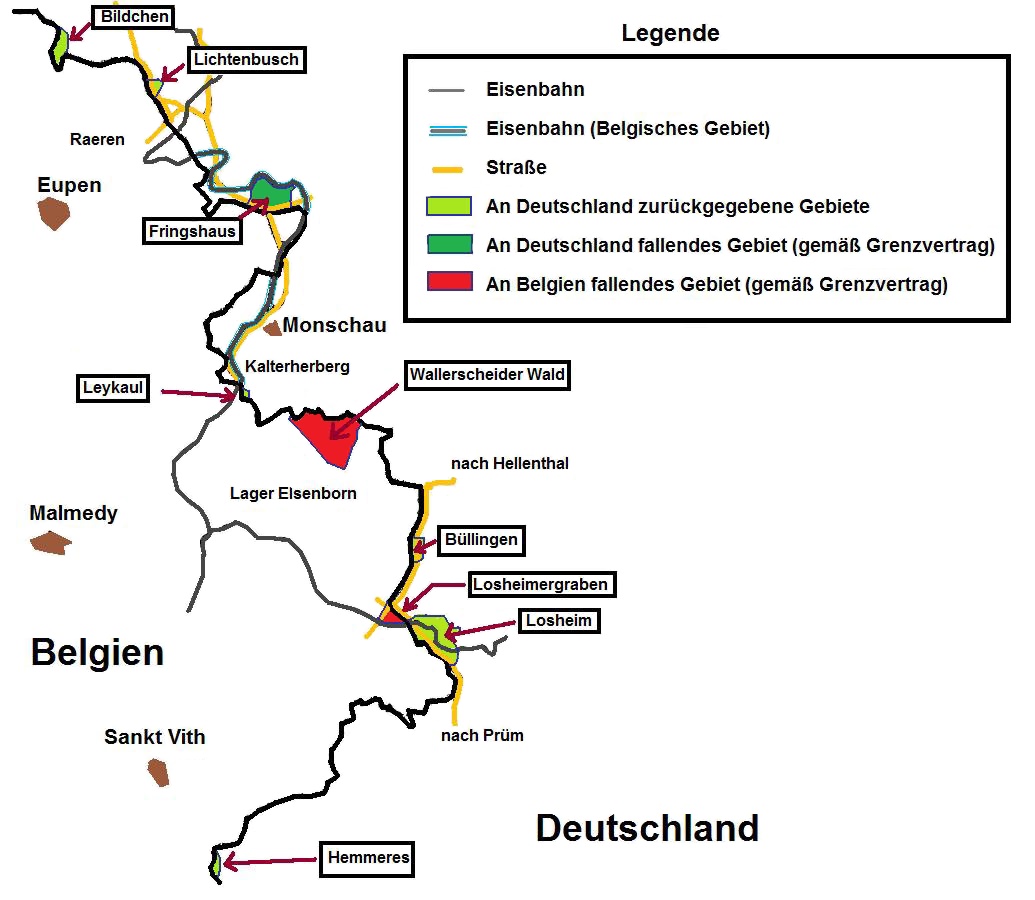
Belgrenz.jpg - Kontrollstellekundl

Carte Crash Halifax.jpg - Rozol 77
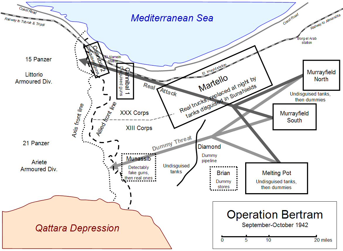
Map of Operation Bertram.jpg - Chiswick Chap
Union franco-britannique.png - SenseiAC

Ammunitionsager i Haderslev.svg - Winbladh

17 гкд на 25.08.1941.jpg - Nisse2

Bases afrique.jpg - Bobdenard57

Churchill War Rooms - the map room.JPG - Frankemann
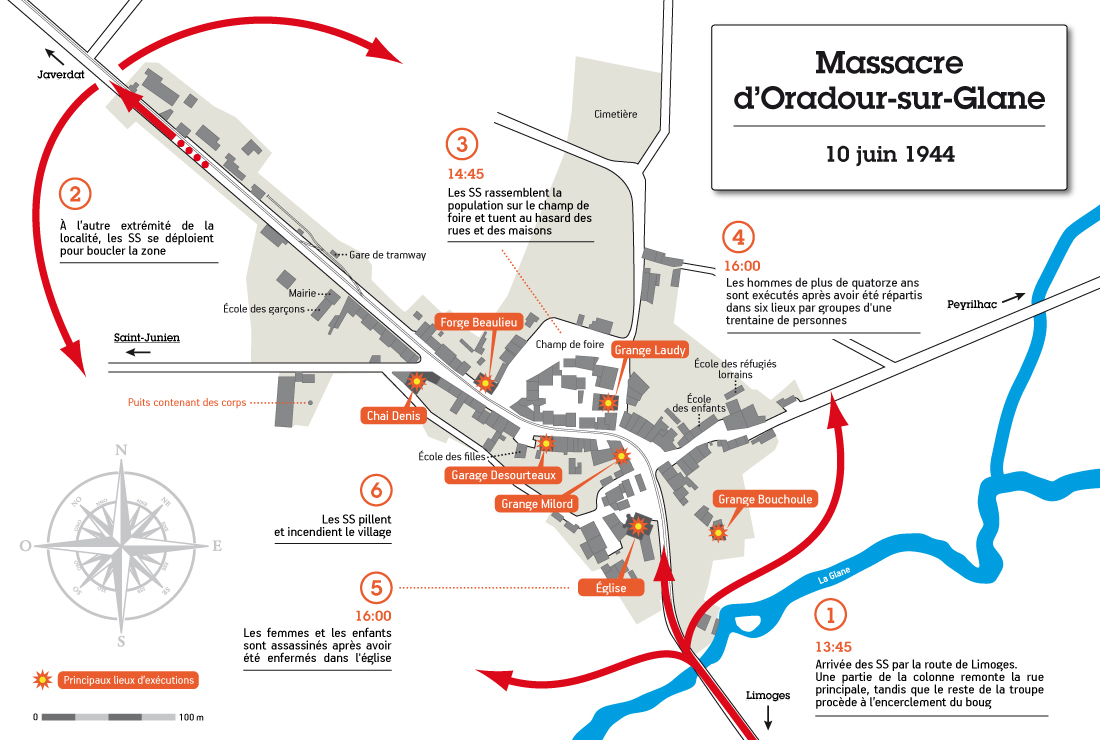
Massacre d'Oradour-sur-Glane2.jpg - Rozol 77

Submarine action Malacca Strai 1944.png - FastilyClone
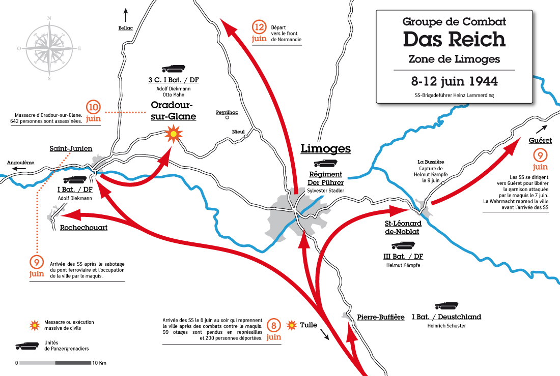
Das Reich - Zone de Limoges 8-12 juin 1944.jpg - Rozol 77

Leyte Landing, X Corps - 20 October, 1944.jpg - Emerdog

Trinity Test Site.jpg - Hawkeye7

The Remagen Bridgehead.jpg - Btphelps

Oak Ridge area 1942.jpg - Hawkeye7

1943 WWII map of Hannover, Germany.jpg - Dnllnd

New Britain WW2 map.jpg - Hohum

MacarthursMilitaryGovernmentUnitsJan1946.png - Sarge8284

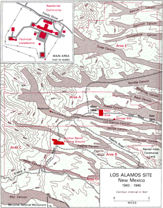
Los Alamos map.gif - Hawkeye7

Map. Battle area on the eastern front.jpg - Puik

Poland in 1939.jpg - Kaldari

KantokuenWikiMap.png - The Pittsburgher

Indian exodus from Burma to Manipur, Bengal, and Assam, January to July 1942.jpg - Fowler&fowler

Stalins attack-plan.jpg - Chasetherabbit1

Denmark Administrative 1942-1945.png - ArdadN

Danmarks administrative inddeling 1942-1945.png - ArdadN

1945 Europako mugetan izandako aldaketak.jpg - AnttonUgarte

D-3 (Enemy) Situation - NARA - 100359954 (page 1).jpg - US National Archives bot

D-3 (Enemy) Situation - NARA - 100359954 (page 2).jpg - US National Archives bot

German Counteroffensive Revised Plan 24 December 1944 and Dec 1944 - NARA - 100384825.jpg - US National Archives bot

Group Engineer Areas of Responsibility for the Month of August - NARA - 100384823.jpg - US National Archives bot

Illustrated Map of the 29th Infantry Division - NARA - 18558245 (page 1).jpg - US National Archives bot

Illustrated Map of the 29th Infantry Division - NARA - 18558245 (page 2).jpg - US National Archives bot

Map made by the Command of General Patch - NARA - 100384760 (page 1).jpg - US National Archives bot

Map made by the Command of General Patch - NARA - 100384760 (page 2).jpg - US National Archives bot

Mimeographed Map of Busching Defensive Position OVERLAY - NARA - 100385231.jpg - US National Archives bot

Post-Operations Map - Philippine Islands - NARA - 100384981.jpg - US National Archives bot

Proposed Army Road Network showing Road and Bridge Status as of 18 September 1944 - NARA - 100385003.jpg - US National Archives bot

Proposed Army Road Network showing Road and Bridge Status as of 21 October 1944 - NARA - 100384997.jpg - US National Archives bot

Proposed Army Road Network showing Road and Bridge Status as of 7 October 1944 - NARA - 100384999.jpg - US National Archives bot

Situation Map 1-31 October 1944 Aachen - Luxembourg - NARA - 100385141.jpg - US National Archives bot

Types of Soil Overlay Sheet 4 - NARA - 100384424 (page 1).jpg - US National Archives bot

Types of Soil Overlay Sheet 4 - NARA - 100384424 (page 2).jpg - US National Archives bot

Types of Soil Overlay Sheet 5 - NARA - 100384421 (page 1).jpg - US National Archives bot

Types of Soil Overlay Sheet 5 - NARA - 100384421 (page 2).jpg - US National Archives bot

Invasion of Philippines Complete - NARA - 50925962.jpg - US National Archives bot

Invasion of Philippines Rough Draft - NARA - 50925948.jpg - US National Archives bot

Leyte Map Base - NARA - 50925966.jpg - US National Archives bot

Polandball map of the World War II.png - Universalis
J-1903 - NARA - 131503695 (page 7).jpg - US National Archives bot

Fire Plan for Attach by 3 British Regiment Infantry Division Operation- "Constellation" 11 October 1944 - NARA - 100384847.jpg - US National Archives bot

The Japanese Shipping Position for 1942 - NARA - 100306985.jpg - US National Archives bot

Map of Poland August 1939.png - Ted52

Route map 1139th Engineer Combat Group 1944 - 1945.jpg - SpencerMSmith

1939 set of maps illustrating the German invasion of Poland in World War II - verso with explanations.jpg - Balkanique

1943 Army Orientation Course Newsmap of the Mediterranean Sea and North Africa.jpg - Balkanique

Philippine Campaign Office of AC of S G-3, Eighth Army Compiled by Sgt. James E. Applegate Designed By Sgt. Clyde J. Singer. Reproduced By 67th Engineer Topo. Co. SWPA 1945 . ..jpg - Balkanique

Allied Air Offensive against Germany Up To January 1st 1941.jpg - Balkanique

Offensive Aerienne des Allies contre l'Allemagne Jusqu'au 1 Fevrier 1941.jpg - Balkanique

American World War II Aeronautical Map of Eastern Asia.jpg - Balkanique

Ein Jahr Krieg - 1. September 1939 bis 31. August 1940.jpg - Balkanique

Triumphal Map of the 36th Infantry Division Campaigns in France, Germany, Austria.jpg - Balkanique

Triumphal Map of the Operational Movement of the 575th Motor Ambulance Company in the European Theatre of Operations Showing Routes and Command Post Locations.jpg - Balkanique
Total war battle map.tif - Balkanique
The victory war map.tif - Balkanique
Japan, the target - a pictorial Jap-map.tif - Balkanique

Newsmap Monday June 12, 1944 - map showing the Normandy landings.jpg - Balkanique

Newsmap Monday June 12, 1944 showing the Normandy landings.jpg - Balkanique

Battlefield Composite Map of Okinawa.jpg - Balkanique

Carte de la mondialisation du conflit.jpg - MémorialCaen

Overlay No. 4 to Accompany G-2 Estimate of the Enemy Situation - DPLA - 4cdecd6d484ebad8ce26099f7a7d15ae.jpg - DPLA bot

Kaart in papier, collectie Raakvlak, BR13-TB-1.jpg - SoetaertAlexander

1940년 제안 프랑스-영국 연합 지도.png - Antonychris

1944 MAP OF ASIA from the book - “The War in Outline 1939-1943 Materials for the Use of Army Orientation Course” prepared by the War Department - (IA warinoutline193900unit 0) (page 178 crop).jpg - Ooligan

St. Nazer.jpg - Краљевић Марко

Service Commands.png - Hawkeye7

Corps areas with corps mobilization responsibilities, 1921.jpg - Hawkeye7

Italian Invasion 1940 in Pindus Epirus ru.svg - Alex Rott
Saw40.jpg - Ramonjos

Major Japanese War Objectives map.jpg - Ooligan

Cerasuolo winterline map 1943.jpg - Marco Marotta

Story of the War, 1945.jpg - Babelia

Palau Islands relief map showing Operation Stalemate.jpg - Hungrydog55

Italian Campaign, course taken by 10th Mountain Division - DPLA - 1e7a1a7652d29fa652ba25837e461da9.jpg - DPLA bot

Map - DPLA - 4eef151dc8628485eb08bf942471fe02 (page 2).jpg - DPLA bot

Defense Barrier Report No. 2 2 September 1945 - DPLA - a28316e2832027039aa75ee33825f6dc (page 1).jpg - DPLA bot

Defense Barrier Report No. 2 2 September 1945 - DPLA - a28316e2832027039aa75ee33825f6dc (page 2).jpg - DPLA bot

Defense Barrier Report No. 2 2 September 1945 - DPLA - a28316e2832027039aa75ee33825f6dc (page 3).jpg - DPLA bot

A Sketch of the Country comprehending the Line of Demarkation between the Spanish Provinces and the United States' Territory from Sabine River, to the 42nd degree of North Latitude, - DPLA - a6864160356e0f38a68557e125d07548.jpg - DPLA bot

Defense Barrier Report No. 2 2 September 1945 - DPLA - c43a60a14bac9ecb9af8363db1f70086 (page 1).jpg - DPLA bot

Defense Barrier Report No. 2 2 September 1945 - DPLA - c43a60a14bac9ecb9af8363db1f70086 (page 2).jpg - DPLA bot

Barrier Plan as of 12 1800 January 1945 - DPLA - a8f0de167f9718cc56147c4bc2d7fe67.jpg - DPLA bot

Unidentified Map - C.C.C.P - DPLA - 50889e8b0e729d8a42caaf637174ee7b.jpg - DPLA bot

Barrier Plan as of 12 1800 January 1945 - DPLA - 44913f3929939801fa1465036cbc90ee.jpg - DPLA bot
Map of world 1943.jpg - SteinsplitterBot

Unidentified Map - C.C.C.P - DPLA - eeca2944c5ad85a519164ab78220c3ed.jpg - DPLA bot

Unidentified Map - C.C.C.P - DPLA - da6c3766244bdc89d790e93c15128432.jpg - DPLA bot

Barrier Plan as of 12 1800 January 1945 - DPLA - 4c06b7a5e086aa9d3532b9756a2ab6ac.jpg - DPLA bot

Unidentified Map - C.C.C.P - DPLA - 437f1cac3927ab76674222e457fcdb74.jpg - DPLA bot

Barrier Plan as of 12 1800 January 1945 - DPLA - e0b9e2f03727dcdedd19d12cb369a63a.jpg - DPLA bot

Defense Barrier Report No. 2 2 September 1945 - Nideggen - DPLA - 6f15bc605bc9810818d5591c0fe10056 (page 1).jpg - DPLA bot

Defense Barrier Report No. 2 2 September 1945 - Nideggen - DPLA - 6f15bc605bc9810818d5591c0fe10056 (page 2).jpg - DPLA bot

Unidentified Map - C.C.C.P - DPLA - bb559b49ae9610064ad45fcbd2ab0afd.jpg - DPLA bot
Map - DPLA - 045f8ccb6d68b3121a962d1e3110a2d7.jpg - DPLA bot

Unidentified Map - C.C.C.P - DPLA - a720d2c10ac082db3eb73f3ce9ba69b8.jpg - DPLA bot

Unidentified Map - C.C.C.P - DPLA - 980de42f3c4eae623dac37cded410beb.jpg - DPLA bot

Barrier Plan as of 12 1800 January 1945 - DPLA - eecea34111c541fb551a3a8ac87a1f86.jpg - DPLA bot

Foum Zguid, Morocco in the 1930s -- J-1903 - NARA - 131503695 (page 7) (cropped).jpg - Ooligan

Atlantic arena, 1942.jpg - Universalis

Map of B-29 range from Saipan.svg - Wtfiv

Four-Power Axis Pact (Proposal of the Axis Powers and the USSR to divide the world in 1940).jpg - Sr L

Global combat.jpg - Universalis

World War II - Pacific Area.jpg - Babelia