Wikimedi'Òc
Modes d'emploi

Cet album fait partie des albums
Cet album photos contient les sous-albums suivants :


Party registration by New Mexico county.svg - Scribetastic

Trinity fallout.png - Dake~commonswiki
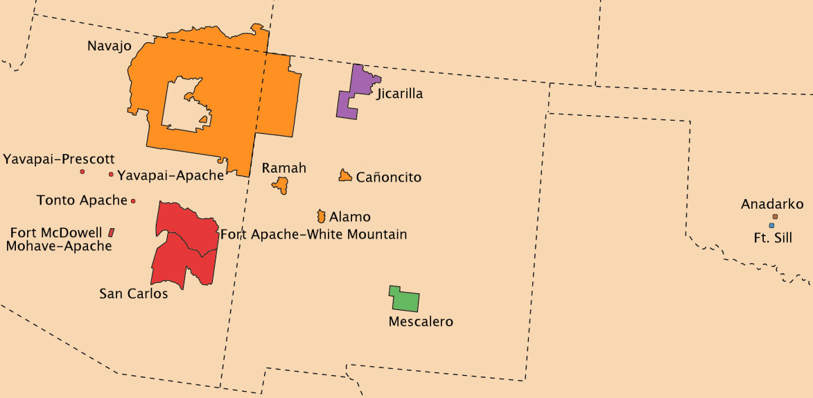
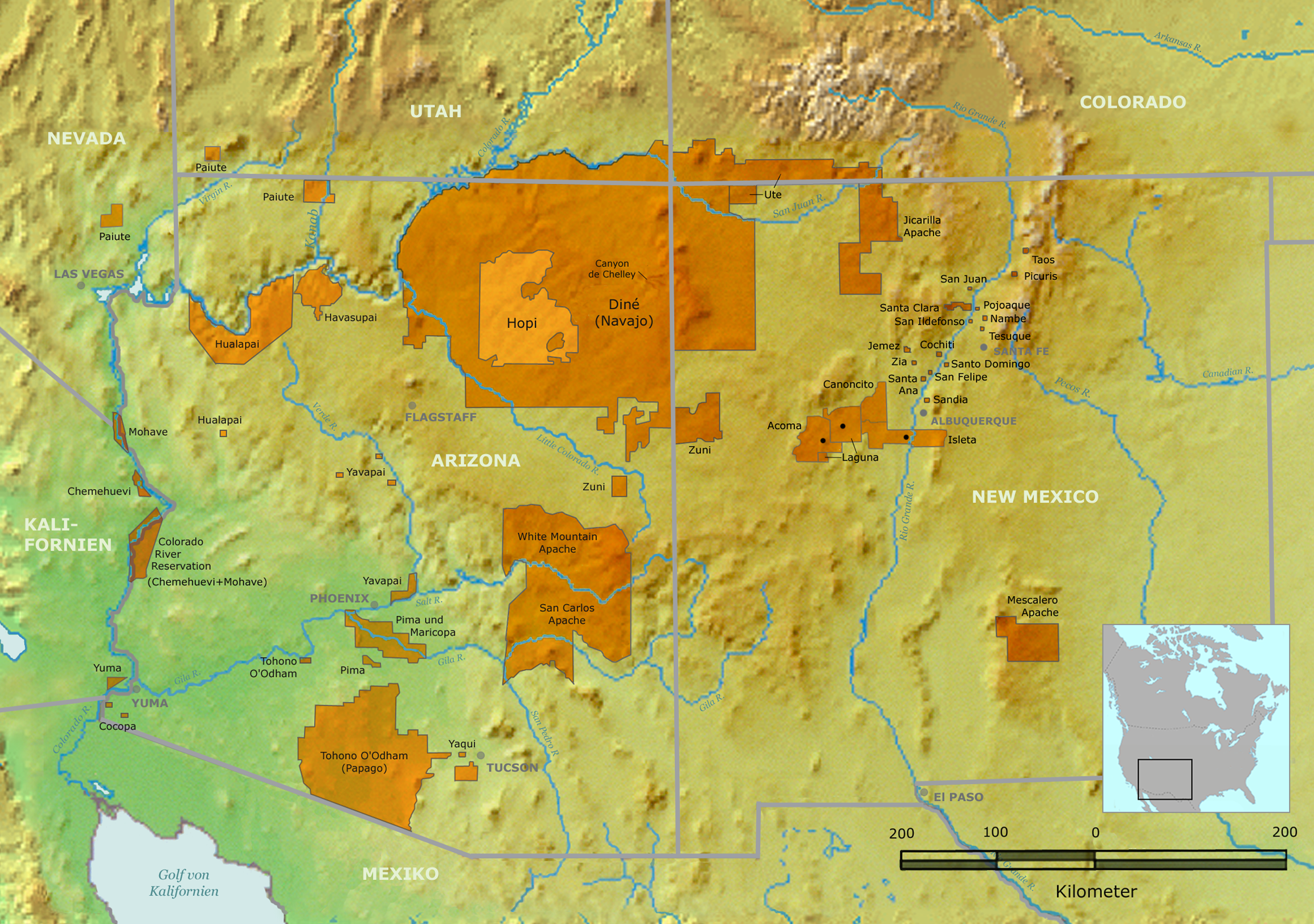
Wohngebiet Diné.png - Nikater
Langer Marsch.png - Nikater
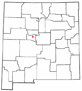
NMMap-doton-SilverCity.PNG - Head

Newmexico 90.jpg - Leslie

Whitesandsmap.png - Huebi~commonswiki

San Juan Basin Prehistoric Roads.jpg - Ras67

Map of White Sands National Monument.png - Huebi~commonswiki

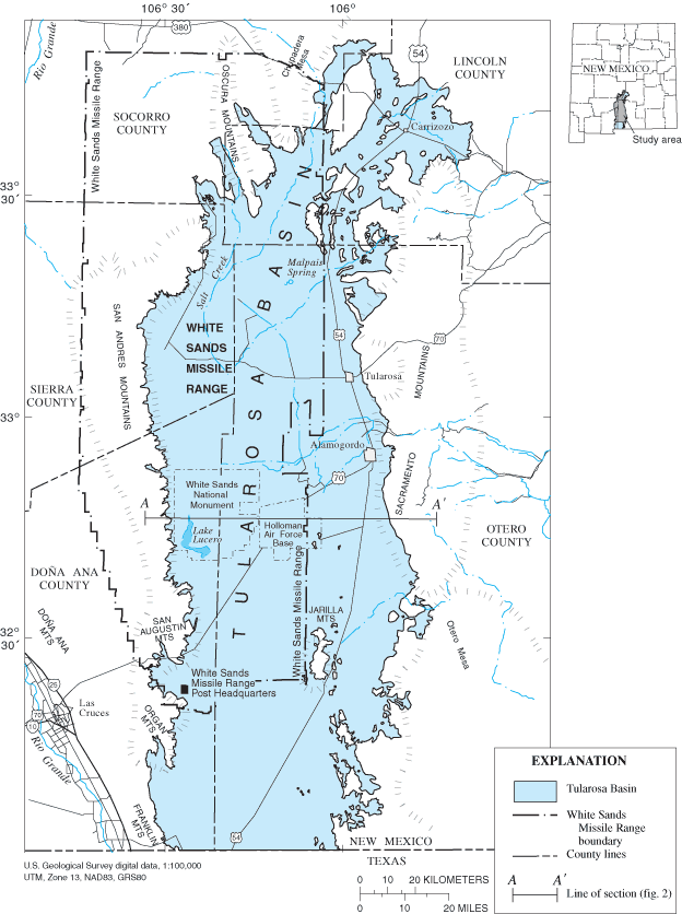
Tularosa-Basin-NM-USGS-map.gif - Bejnar
Apachean present.png - Ish ishwar

Delaware Basin geology exhibit.JPG - Mav
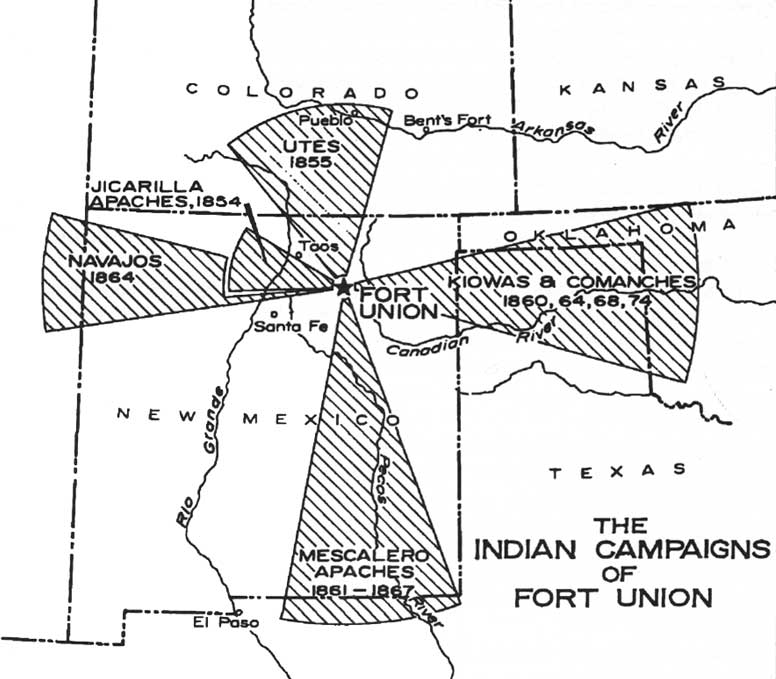
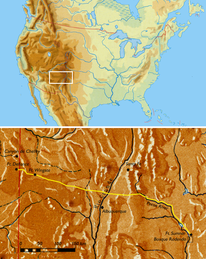
Foun indian campaigns.jpg - Finavon

Chihuahua desert.jpg - Pfly
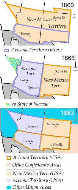
Wpdms new mexico territory 1866.png - Starscream

Chaco Canyon.jpg - DVD R W

Pueblo01.png - Nikater
Riogranderiobravo.PNG - SieBot

Sapu map1.jpg - H-stt
NMMap-doton-Valencia.PNG - SieBot

Santa Fe National Forest Jemez District.jpg - BetacommandBot
Südwesten01.png - Nikater
Tularosa-Basin-NM-USGS-map opaque.gif - AnonMoos

TX-NM storm Nov 24-2007.jpg - DragonFire1024

Map of Territorio de Nuevo Mexico.PNG - Mixcoatl
New Mexico Locator Map with US.PNG - Kaldari
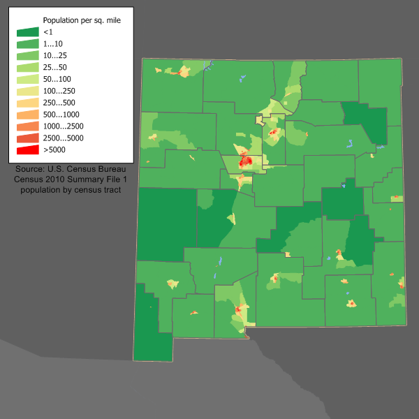
New Mexico population map.png - JimIrwin

Plains-of-San-Agustin-watershed.gif - Bejnar

Miami-NM-from USGS-quadrangle.jpg - Bejnar

NM-sierra.jpg - Paalexan~commonswiki

NM-south-central.jpg - Paalexan~commonswiki

New Mexico wind resource map 50m 800.jpg - Teratornis

Evolucion Territorio Mexicano.gif - Jaimiko

Ogallala area freshwater ground withdrawals all aquifers.png - Kbh3rd

San Juan Basin Prehistoric Roads HEB.jpg - רוליג

Map of Carlsbad Caverns National Park-HE.png - Ori~

Evolución territorial de México (1821-1981).gif - Keepscases

Map of World War II Japanese American internment camps.png - Ras67

Traditional az map.gif - File Upload Bot (Magnus Manske)

Progession Map for Las Conchas Fire. 6 30 11, 14 00.jpg - File Upload Bot (Magnus Manske)
New Mexico, Future Home of The Center.jpg - Purple Scot

SantaFeTrail~1845.jpg - ELApro

Map of Manzano Mountains.jpg - Smallchief

Pecos wilderness map.jpg - Smallchief
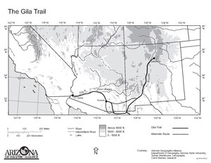
Map of the Gila Trail.pdf - $1LENCE D00600D

Arizona territory 1860.png - Valdis72

Arizona new mexico territories 1863.png - Valdis72

New mexico territory 1866.png - Valdis72
New mexico territory 1860-1866.png - File Upload Bot (Magnus Manske)

Middle Rio Grande Basin.gif - Aymatth2
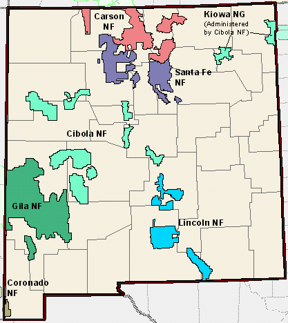
New Mexico National Forest Map.gif - Fredlyfish4

Belen map.png - MGA73bot2

New Mexico topographic.jpg - TheAustinMan

RoswellIncidentCrashSite.jpg - Michael Jester
Wpdms arizona territory 1860 idx.png - File Upload Bot (Magnus Manske)
NM1996.png - 7partparadigm

New Mexico marriage laws.PNG - Kudzu1

20120613 WWBC PIO 20x20 (7184310215).jpg - File Upload Bot (Magnus Manske)

June 11 Map (7177117557).jpg - File Upload Bot (Magnus Manske)

20120609 WWBC PIO 20x20optim (7169345807).jpg - File Upload Bot (Magnus Manske)

June 6 Map (7345000594).jpg - File Upload Bot (Magnus Manske)

June 3 Fire Progression Map (7329702662).jpg - File Upload Bot (Magnus Manske)
Progression Map May 30 (7309253590).jpg - File Upload Bot (Magnus Manske)

May 31 Progression Map (7310013746).jpg - File Upload Bot (Magnus Manske)

Progression Map May 29 (7296140404).jpg - File Upload Bot (Magnus Manske)

Progression Map (7287321294).jpg - File Upload Bot (Magnus Manske)

May 27 MAP (7282121762).jpg - File Upload Bot (Magnus Manske)

Pecos map.jpg - Reinhard Kraasch

Map of the Republic of Texas and the Adjacent Territories, 1841.jpg - Mdd

Cimarron-nm-map.png - GifTagger
Cutural-Northern-New-Mexico.png - GifTagger

Dunes Drive in WSNM.png - GifTagger

Annual report of the Bureau of American Ethnology to the Secretary of the Smithsonian Institution (1895) (18738664644).jpg - SteinsplitterBot

Bulletin (1906) (20423554205).jpg - Fæ

The Commercial and financial chronicle (1906) (14778888921).jpg - SteinsplitterBot

History and government of New Mexico (1921) (14596493118).jpg - Fæ

The American educator; completely remodelled and rewritten from original text of the New practical reference library, with new plans and additional material (1919) (14598403848).jpg - Fæ

USA Region West relief Guadalupe Mountains location map.jpg - Gemini1980
USA Region West relief San Andres Mountains location map.jpg - Gemini1980

USA Region West relief Sandia Mountains location map.jpg - Gemini1980
New Mexico Köppen.png - Redtitan

Country Club Area.jpg - FastilyClone
Sabinoso Wilderness.pdf - Smallchief
Sabinosa wilderness area managmeent plan. pdf.pdf - Smallchief
Wpdms new mexico territory 1867.png - Josemontoya558

New Mexico - Greetings from.. (NBY 437509).jpg - Fæ

USA Region West relief location map Capitan Mountains.jpg - Gemini1980

USA Region West relief location map Sierra Blanca.jpg - Gemini1980

New Mexico population density 2020.png - Crossover1370

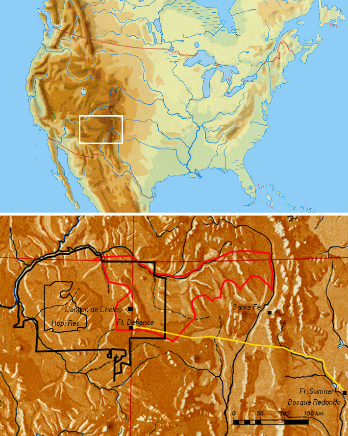
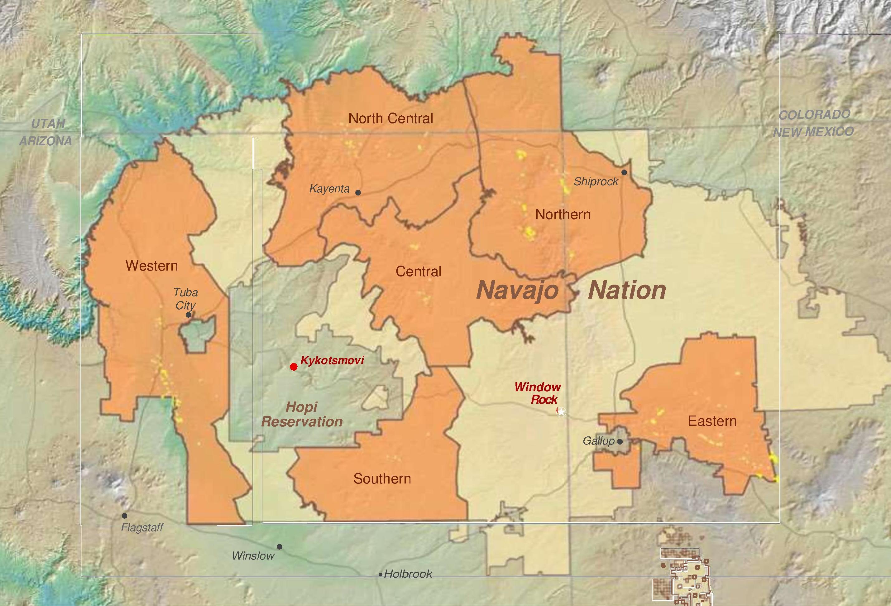
Map of Navajo Areas - NARA - 84785481.jpg - US National Archives bot

Map of the Territory of New Mexico - NARA - 12007699.jpg - US National Archives bot
New Mexico EPA ecoregions.pdf - TimK MSI

Hohokam, Ancestral Pueblo, and Mogollon cultures circa 1350 CE.png - User-duck
Map detail, from- Abandoned Uranium Mines and the Navajo Nation (page 1 crop).jpg - Tibet Nation
Forest atlas of the national forests of the United States. Jemez folio (IA CAT31291573).pdf - Fæ

Sheets 8 and 9 - DPLA - 518fef07173a2e6943456c812be9fede.JPG - DPLA bot

Sheets 16 and 17 - DPLA - 8849ec9437b9fcdab76d1e2e7d07968d.JPG - DPLA bot

SPSA map 18.jpg - Kehkou

Outline Map of Part of Southwestern New Mexico - DPLA - 77cd25c3d463847dafe5a899121f02cf (page 1).jpg - DPLA bot

Outline Map of Part of Southwestern New Mexico - DPLA - 77cd25c3d463847dafe5a899121f02cf (page 2).jpg - DPLA bot

Geologic Map of New Mexico Explanation.png - Puckish pupfish

Physiographic provinces of New Mexico (26846109601).jpg - Ltn12345

Possible Coronado Expedition Routes as found by Bolton, Riley and Winship.png - Indianertosset

Possible Coronado Expedition Routes as found by Day, Donoghue and Wedel.png - Indianertosset
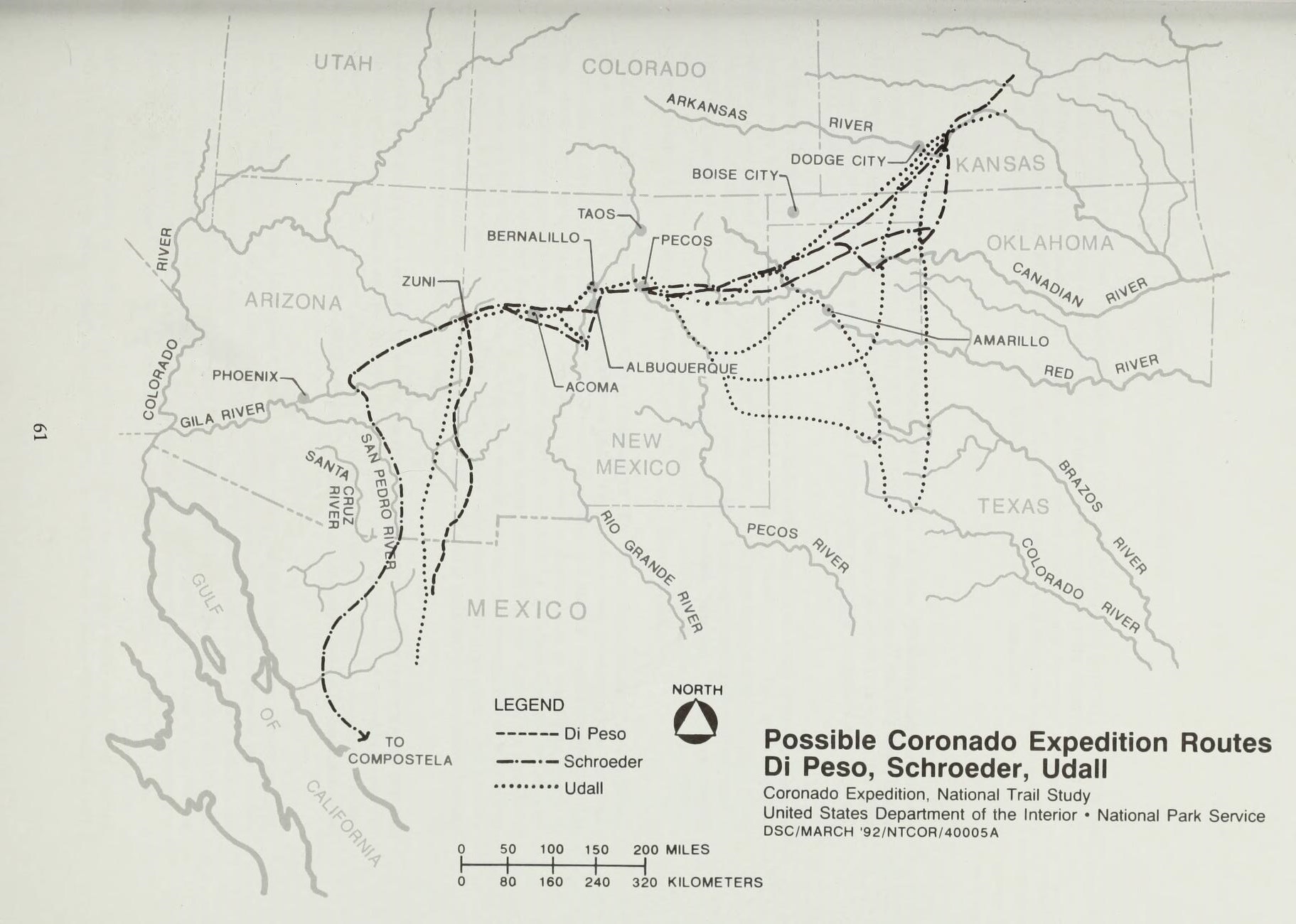
Possible Coronado Expedition Routes as found by Di Peso, Schroeder, Udall.png - Indianertosset

Population density of New Mexico counties (2020).png - Austiger

Lake Estancia and Lake Willard.png - Guerillero

New Mexico voter registration by party as of February 2021.svg - Putitonamap98

Piro people, New Mexico.jpg - Smallchief

NM20CD2A.svg - Alexodiaz4991
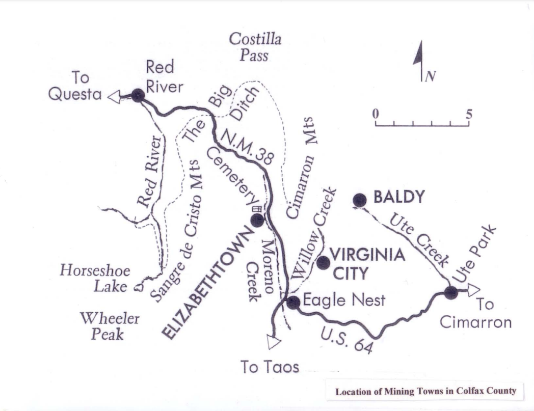
Location of Mining Towns in Colfax County.png - AmateurHistory01

1850 California, Oregon, Utah, New Mexico Map.jpg - SDudley

Gallina region map.png - Hopeful-academic
Map of "Uranium Worker" States by the United States Department of Justice.png - Ooligan
Geothermal resources of New Mexico.pdf - Jengod
Ardf map.png - Greudin

Sante Fe, New Mexico 1959.jpg - Marsonmars