Wikimedi'Òc
Modes d'emploi

Cet album fait partie des albums
Cet album photos contient les sous-albums suivants :


Great Lakes Lake Ontario.png - Daniel FR

Great Lakes Lake Superior.png - Daniel FR

Ports Colbourne, Weller, Maitland.PNG - Geo Swan

Lake-Ontario.svg - File Upload Bot (Magnus Manske)
Ontario outline.gif - Threecharlie

Drumlinfield large.jpg - File Upload Bot (Magnus Manske)

Irondequoit Bay, NY State.gif - Geo Swan

Lake-Superior-red.png - Rcsprinter123

Lake-Ontario-red.png - Rcsprinter123

Lake Ontario Watershed.png - Drdpw

Chippewa and Stanley Low Levels (Larsen 1987).jpg - Chris Light

Huronie.JPG - Donnacona
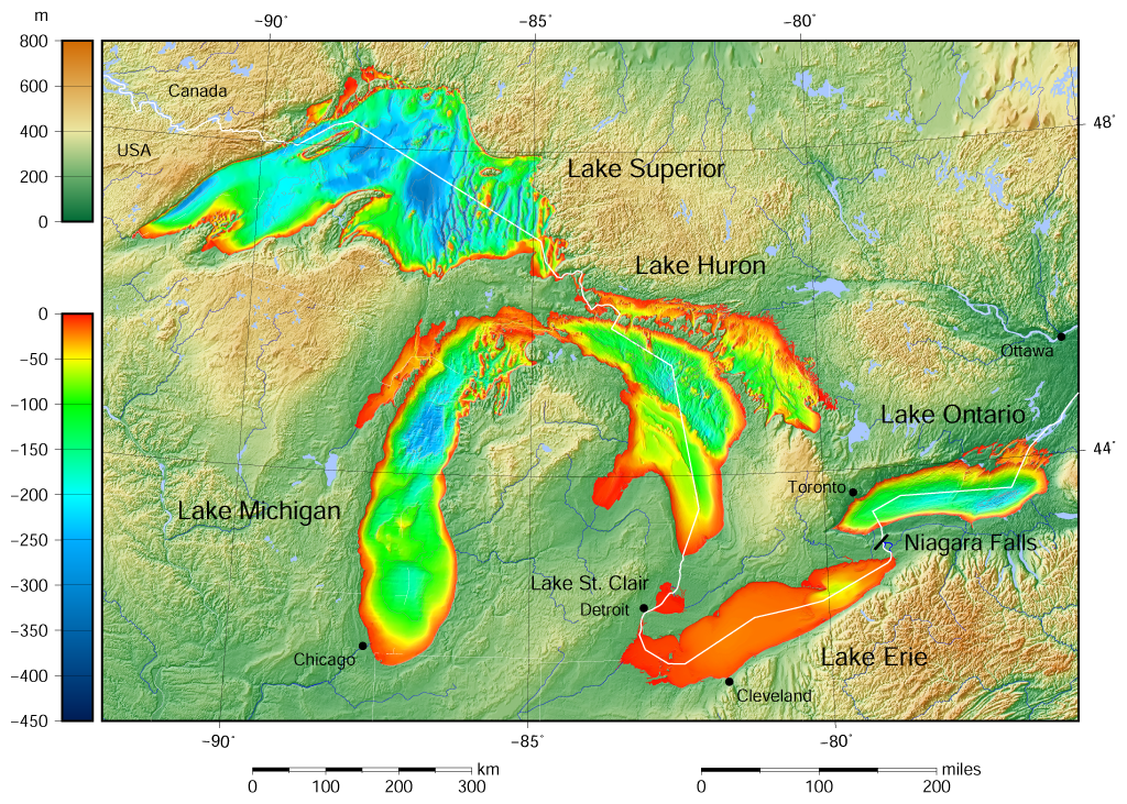
Great Lakes bathymetry map.png - Darekk2

Great Lakes bathymetry map 2.png - Darekk2

Lake Ontario bathymetry map 2.png - Darekk2

Lake Ontario bathymetry map.png - Darekk2

FMIB 42197 Lake Ontario Whitefish area (shown in black), 10 to 20 fathoms.jpeg - BMacZeroBot

Index to the reports of the chief of engineers, U.S. Army (including the reports of the Isthmian Canal Commissions, (1899-1914) 1866-1912 (1915) (14583464409).jpg - SteinsplitterBot

NOAA map of Scotch Bonnet Ridge.jpg - Geo Swan
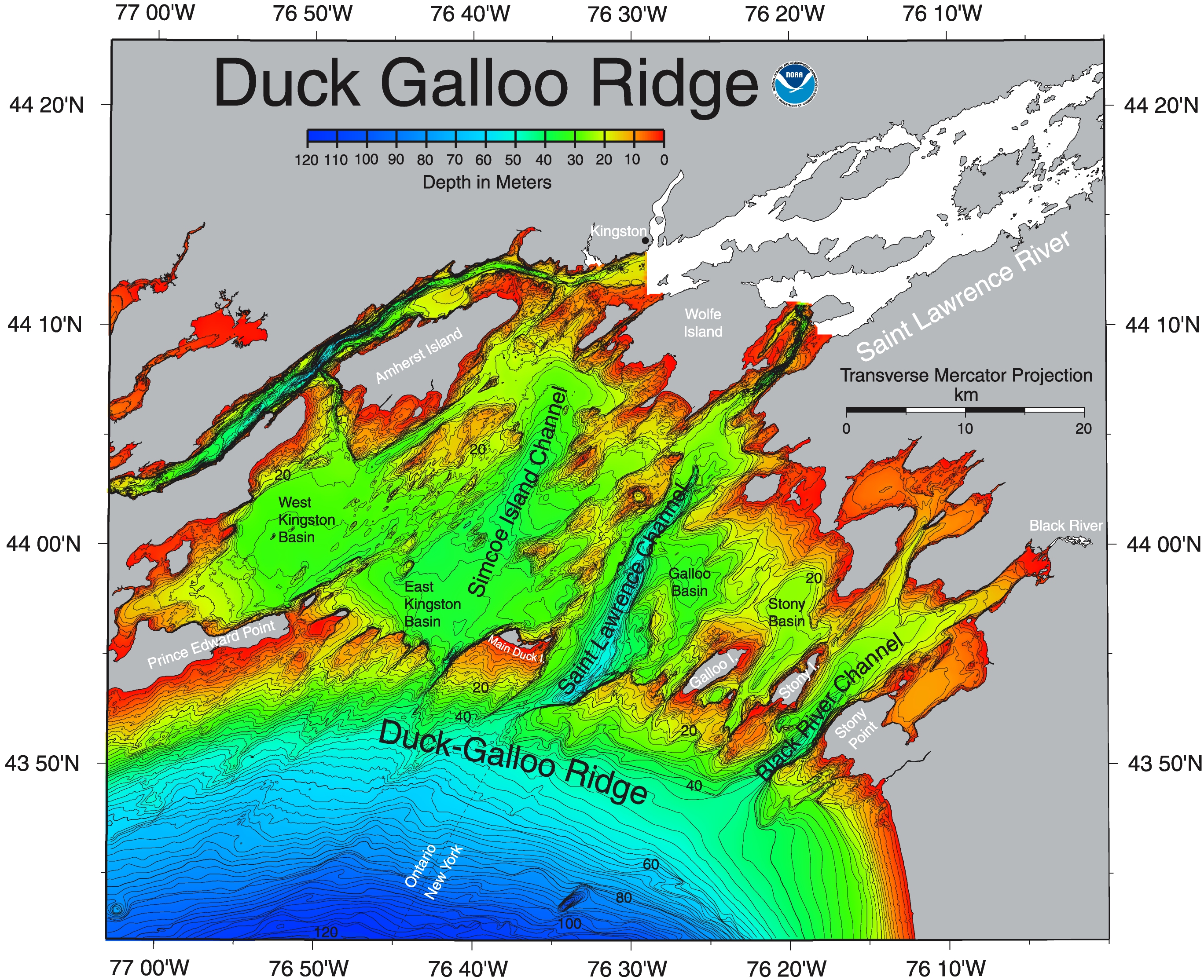
NOAA map of Duck Galloo Ridge.jpg - Geo Swan

NOAA map of Charity Shoal in Lake Ontario.jpg - Geo Swan

NE-SW arc on the floor of the Rochester Basin, resemble grooved topography in onshore drumlin fields showing glacier direction.jpg - Geo Swan

NOAA map of Irondequoit Bay.jpg - Geo Swan

Another NOAA map of Lake Ontario.jpg - Geo Swan

Bay of Quinte, NOAA.jpg - Geo Swan

NOAA map of Duck Galloo Ridge (cropped) showing Timber, Swetman, Main Duck and Yorkshire islands, and some subsurface shoals.jpg - Geo Swan

NOAA bathymetric map of the Niagara Fan.jpg - Geo Swan

NOAA Bathymetric map of the Niagara Basin.jpg - Geo Swan

NOAA bathymetric map of the West and East Kingston Basins.jpg - Geo Swan

NOAA bathymetric map of Lake Ontario's Rochester Basin.jpg - Geo Swan

National Scenic Byway - Great Lakes Seaway Trail (multistate) - NARA - 68886953 (page 7).jpg - US National Archives bot

Great Lakes Seaway Trail - Map of the Seaway Trail - NARA - 7718835.jpg - US National Archives bot

Breeze - Toronto, Rochester ferry.png - Geo Swan

Communities of the Greater Toronto Area 2.png - Geo Swan

Fig 10 Diagram of Lake Ontario.jpg - Chris Light
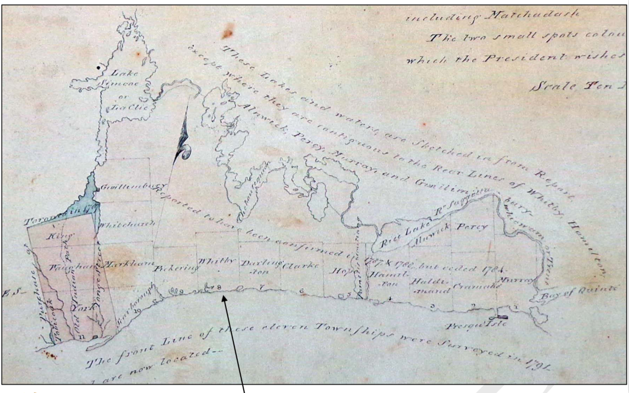
Genticore plate, Upper Canada.png - SteinsplitterBot

Jmse-04-00046-g001-1024.png - HJVerhagen

East End of Lake Ontario.png - Charalampos Nikolakopoulos

2024 Lake Ontario National Marine Sanctuary map.PNG - Mdnavman

Lake Ontario National Marine Sanctuary map with shipwrecks 2024.PNG - Mdnavman

Part of the central part of the province of Upper Canada shewing the seat of war in the Years 1812, 1813 & 1814 (912-7135c34) (7289022288).jpg - Geo Swan