Wikimedi'Òc
Modes d'emploi

Cet album fait partie des albums
Cet album photos contient les sous-albums suivants :


Mi-map.png - Lojwe
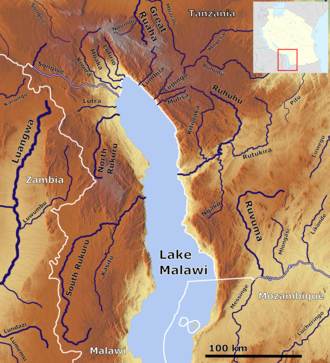
Location GreatLakes-Africa.png - Ras67
Location RegionOfTheGreatLakes-Africa.png - Ras67

Rift.svg - Sting

Lagghi-he.svg - Ori~

Map of Great Rift Valley.svg - Slashme

Map of Great Rift Valley-fi.svg - Haltiamieli
Nyasa outline.gif - Threecharlie

Lake Niassa.png - Aotearoa

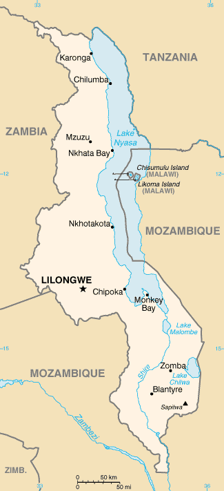
Lake Malawi.jpg - Alter welt

Malawi-Tanzania border dispute.png - Capmo

Map showing Scotland and Lake Nyasa, (s.d.) (imp-cswc-GB-237-CSWC47-LS5-1-014).jpg - Fæ

"The Basin of Lake Nyasa", Malawi, ca.1895 (imp-cswc-GB-237-CSWC47-LS3-1-001).jpg - Fæ

The Tanganyika problem; an account of the researches undertaken concerning the existence of marine animals in Central Africa (1903) (14595883418).jpg - Fæ

Africa (1878) (14773212391).jpg - SteinsplitterBot

The Tanganyika problem; an account of the researches undertaken concerning the existence of marine animals in Central Africa (1903) (14774052232).jpg - SteinsplitterBot

David Livingstone's Map of Lake Malawi, Africa (5372468299).jpg - Fæ

Rift de.svg - Reinhard Kraasch

Rift en.svg - Reinhard Kraasch

Shire Basin OSM.png - Peter in s

Lake Malawie Tanzania OSM.png - Peter in s

"The Basin of Lake Nyasa", Malawi, ca.1895 (imp-cswc-GB-237-CSWC47-LS3-1-001) (cropped).jpg - Tibet Nation

General map showing the Eastern route to Central Africa from Kilimane to Lake Tanganyika - DPLA - ee86c631db60dd5abf693dfa664c10cf.jpg - DPLA bot

South Eastern Africa- Lake Nyassa, the River Shire etc. - DPLA - 220ef659e1da2d7c4a75a2a17c678fed.jpg - DPLA bot

East Africa- Sketch Map of Native Routes from Dar Es Salaam Towards the Head of Lake Nyassa from information obtained by Mr. Keith Johnson, R.G.S. East African Expedition - DPLA - fac68e5ed8201f358afa077f76334120.jpg - DPLA bot

East Africa- The Country East of Lake Nyassa compiled from the Documents of the Rev. W.P. Johnson - DPLA - 2c81223511aede6518355c96958c1fe2.jpg - DPLA bot

Sketch Map of the Route of the R.G.S. East African Expedition from Dar Es Salaam to Lake Nyassa - DPLA - 54b6adbf10086d90277efa978073f7f9.jpg - DPLA bot

Map of the Route of the R.G.S. East African Expedition to Lakes Nyassa & Tanganyika - DPLA - e0713e2ae2c1012a6548363eef5d7532.jpg - DPLA bot

Route Survey of the Western Side of Lake Nyassa (Northern Portion) - DPLA - 1df3bd699030e7fb8b724dea74a08dfc.jpg - DPLA bot

Africa- Lake Nyassa surveyed by Mr. Jas. Stewart, C.E. - DPLA - 88ce4f25de0052073ef48e37a7fe3d34.jpg - DPLA bot

Map of the North End of Lake Nyassa - DPLA - 024d3011c8195f69f086eb42fe9dacd5.jpg - DPLA bot

Map showing Route from the Cape of Good Hope across the Zambezi River at Tette to Lake Nyassa in 1884 - DPLA - 013b06169a316aa3c929b8699e7641a6.jpg - DPLA bot

Map Illustrating Mr. A. Sharpe's Journey from Lake Nyassa to the Loangwa & Upper Zambesi Rivers - DPLA - 8c259a302178a505bd5284316429b367.jpg - DPLA bot

Route Survey of the Western Side of Lake Nyassa - DPLA - d19b8434ef5bc3cfeff8b3d5fbcc509c.jpg - DPLA bot

Route Survey Between Lakes Nyassa & Tanganyika - DPLA - ffe82c0c96b2b374b4527f2b1a98c359.jpg - DPLA bot

Carta della parte di Africa Centrale percorsa dal DrLivingstone tra gli anni 1866 e 1873 e desunta dalle note e dai disegni da esso lasciati - DPLA - 83645aaf03ee8a6304b86d959d337320.jpg - DPLA bot

Geological Sketch-Map of Central Africa - DPLA - 68ff5a974baa137024ee14d1080707b7.jpg - DPLA bot

TZ Nyasa (Malawi).PNG - Kipala