Wikimedi'Òc
Modes d'emploi

Cet album fait partie des albums


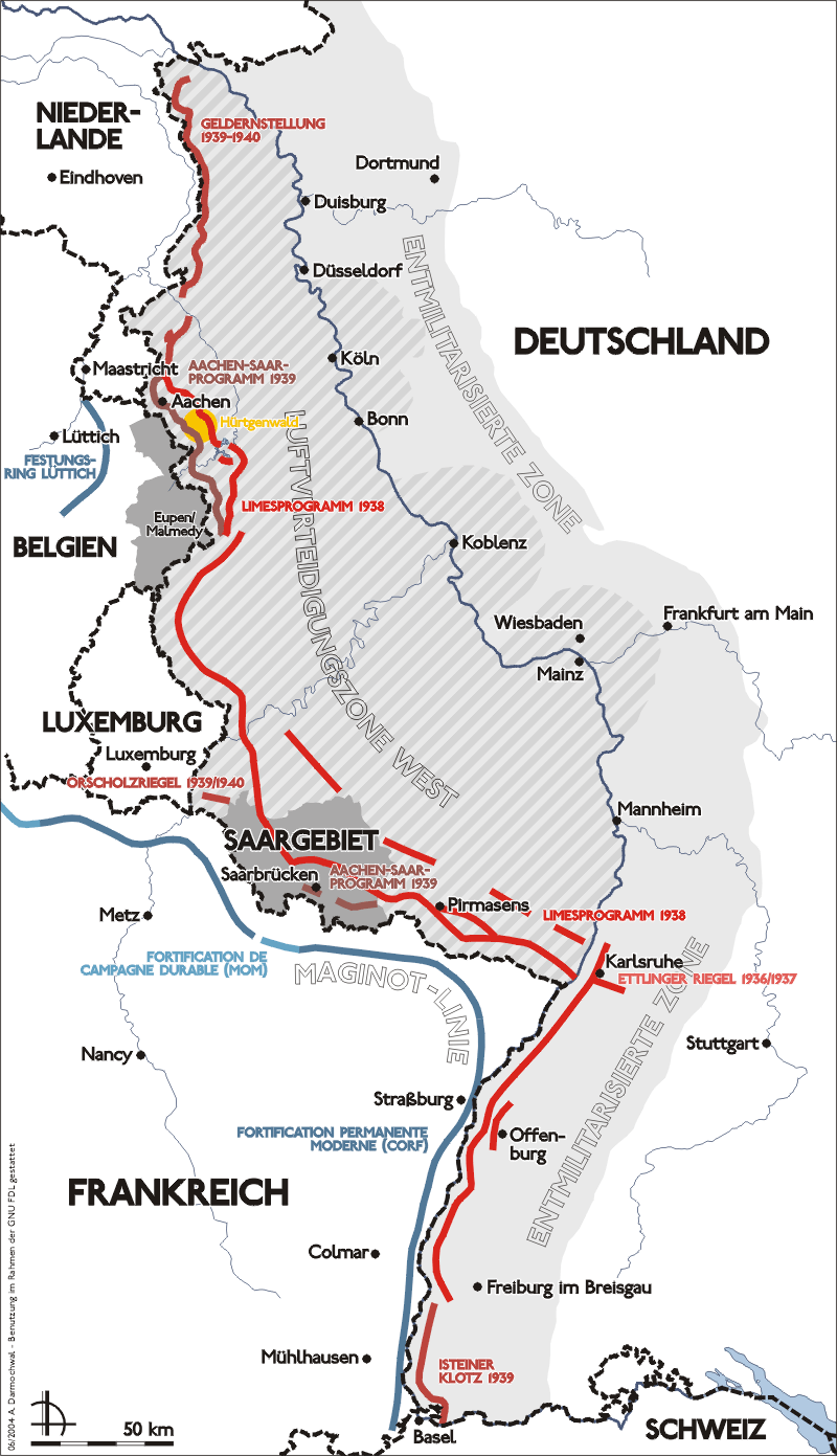
Karte westwall.png - Saperaud~commonswiki
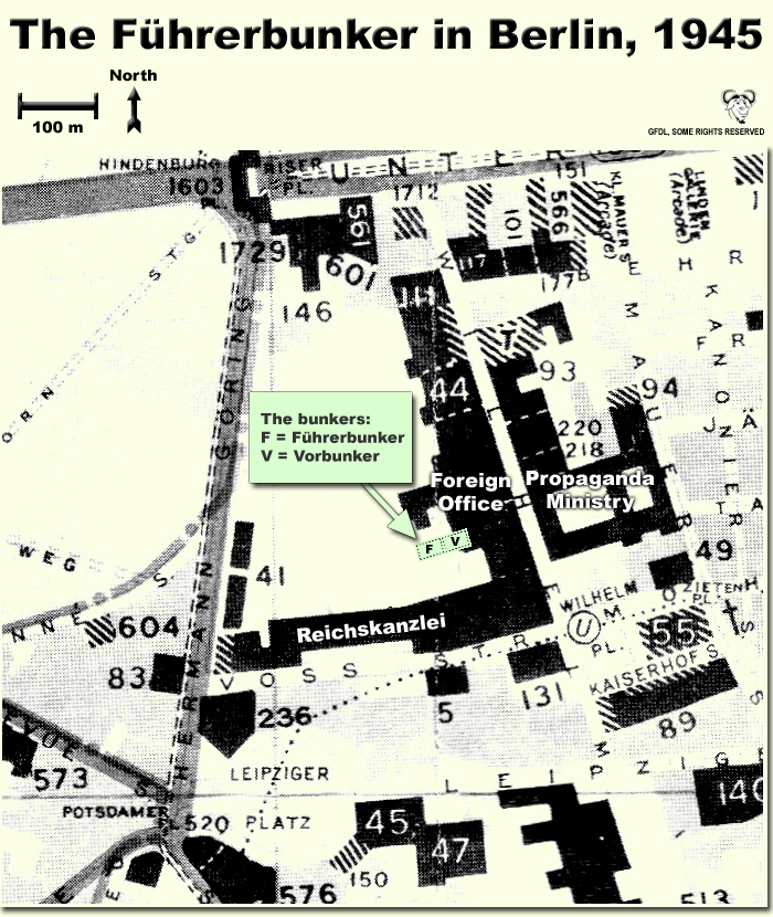
FuehrerBunkerBerlinLocation.jpg - Dna-webmaster~commonswiki

Advance through Germany - 5-18 April 1945.jpg - W.wolny

Dresden Luftangriffe.png - Wiprecht

Karte Rollwald.png - Presse03

GERMAN OPERATIONS AND PLANS.png - CORNELIUSSEON

2009-11-22-seelower-hoehen-by-Ralf-68.jpg - Ralf Roletschek

Battle of Seelow Heights (el).png - Jake V

Übersichtskarte der Bunkerbaustelle Mettenheim Ampfing.JPG - Akp-fmg
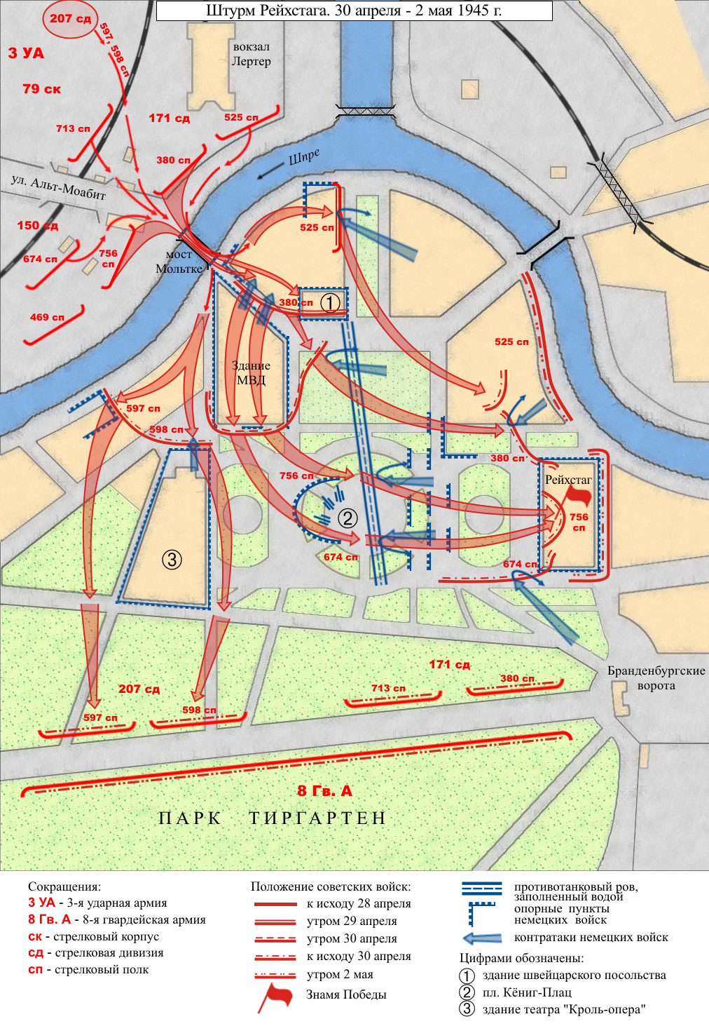
Battle for Reichstag 1945 map-rus.png - Ivengo(RUS)

Battle for Reichstag 1945 map-eng.png - Ivengo(RUS)

Allemagne 45.jpg - Brunoraisin

Allemagne 45.png - Brunoraisin
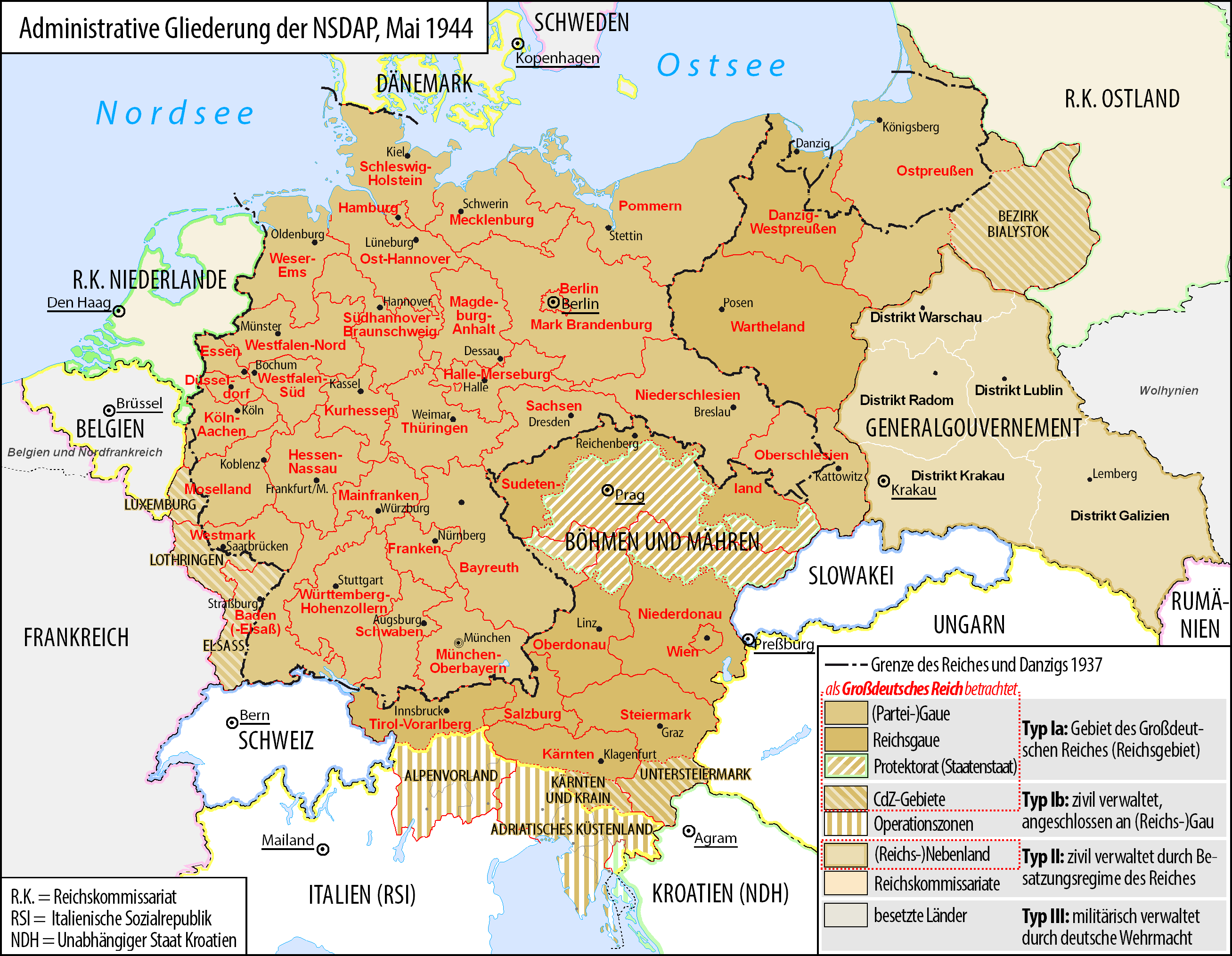
Grossdeutsches Reich NS Administration 1944.png - Exec

La tarjeta del asalto del Reichstag.png - Ivengo(RUS)

La carte de l'assaut du Reichstag.png - Ivengo(RUS)

Operacja berlin 1 1945.png - Lonio17

Schlacht um Berlin.png - Äberlausitzer

Operacja berlin 2 1945.png - Lonio17

Ofensiva del Saar2.jpg - Arderiu

17MAR45Map001.JPG - Upload Bot (Rich Smith)

Berlin 1945.png - Lonio17

BleialfMap 429.jpg - July5ly

Lenino 1943.png - Lonio17
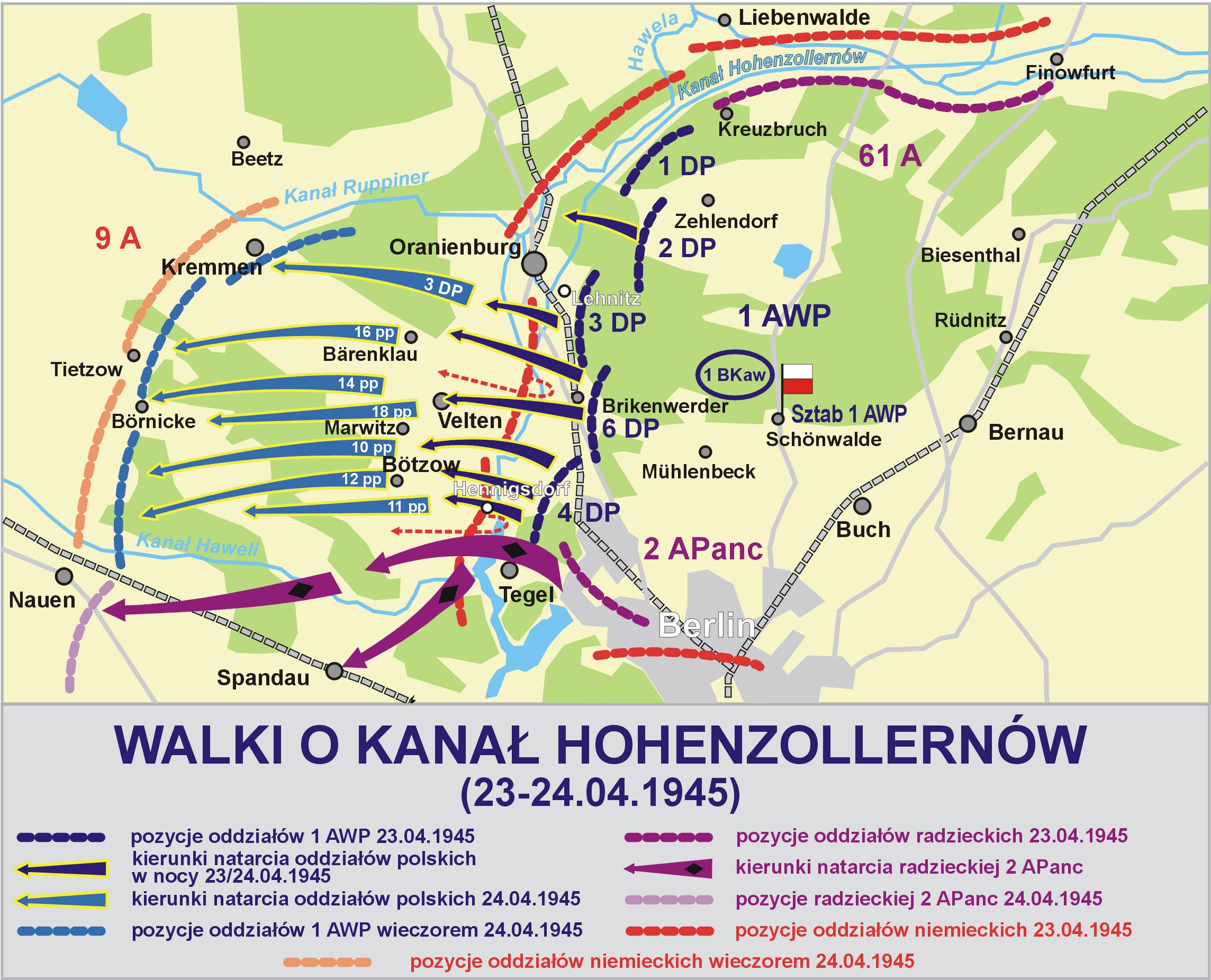
Kanal hohenzollernow 1945.png - Lonio17

Lenino 1943 en.png - Lonio17

WWII - The War of Lines (RU).svg - Hellerick

Planned partition of Asia.png - Spesh531

France map Lambert-93 with regions and departments-occupation evolution.PNG - Victor falk~commonswiki
Areas annexed by Nazi Germany.png - Poeticbent

Verlegung OKW (1945).jpg - Mehlauge

65. US-Infanterie-Division April 1945 - Neumarkt.jpg - DALIBRI

2009-11-22-seelower-hoehen-by-Ralf-68-V2.jpg - Chumwa

German-occupied Europe.svg - AHC300

Battle of Berlin 1945-bj-HU.png - Gabcsé

Military Administration in the Soviet Union (1942).svg - AHC300

Battle for Reichstag 1945 map-hun.png - Gabcsé

Operations of German Communication Intelligence Units against the Balkans and Near East 1941.svg - Goran tek-en

Operations by German Signal Intercept Units during Invasion of France and Low Countries August 1939 to October 1939.svg - Goran tek-en

Operations by German Signal Intercept Units during Invasion of France and Low Countries October 1939 to January 1940.svg - Goran tek-en

Operations by German Signal Intercept Units prior to Invasion of France and Low Countries February to April 1940.svg - Goran tek-en

Operations by German Signal Intercept Units during Invasion of France and Low Countries after April 1940.svg - Goran tek-en

Operations by German Signal Intercept Units against Great Britain July 1940 to January 1941.svg - Goran tek-en

Chart 2 German radio intelligence operations during Norwegian Campaign between 31 March 1940 to 14 June 1941.svg - Goran tek-en

Chart 4 radio intelligence operation findings during French Campaign.svg - Goran tek-en

Chart 6 German radio intelligence operations in the Mediterranean and North Africa theatre March 1943.svg - Goran tek-en

Chart 7 German Communication Circuits used by Intercept Units in Africa and Near East March 1943.svg - Goran tek-en

Chart 9 German Radio Intelligence Operations in Southern Russia 1941-42.svg - Goran tek-en

Allied Occupation Zones of Germany after WW II.jpg - Maximilian Schönherr

Battle of Berlin 1945-a esp.jpg - Posible2006

Map of German annexations in Belgium 1940 (northern part) (Bundesarchiv Koblenz R 43 II 1404 a 0197).jpg - Bancki

Map of German annexations in Belgium 1940 (southern part) (Bundesarchiv Koblenz R 43 II 1404 a 0199).jpg - Bancki

Location map of Gau Westmark.svg - P170

Road and Bridge Reconnaissance Duderstadt - Nordhausen - DPLA - 5455cb5579a4a26ce9d8e12e67d88e45.jpg - DPLA bot

Map flag of Nazi Germany in 1942.png - BrazilNicolas3

Nazi Germany Flag map(1942).png - Zuame

Nazi Germany Flag Map in 1942.png - Merthasank