Wikimedi'Òc
Modes d'emploi

Cet album fait partie des albums
Cet album photos contient les sous-albums suivants :


Geo Sen 16.jpg - Bernkastel5

Geo sen 17 page-0001.jpg - Bernkastel5

GeoSen13 page-0001.jpg - Bernkastel5
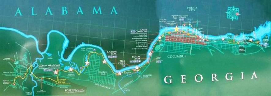
Columbus Auburn-Opelika.png - Columbusganative

Hardee's flank march en.svg - Косоморф
Map of USA highlighting Georgia.png - David.gaya

Georgia 90.jpg - Leslie

Georgia Midland Railroad route map.png - Slambo

Map of Georgia highlighting the Historic South.gif - Patricknoddy~commonswiki

Map of Georgia highlighting the North Georgia mountains.gif - Patricknoddy~commonswiki

Map of Georgia highlighting Southern Rivers.gif - Patricknoddy~commonswiki

Mountain Park Fulton.png - Smeira

C-ONF Map.jpg - BetacommandBot

Map Falls Bartram.jpg - BetacommandBot
FDR state park locator.png - Saucemaster
General coffee park locator.png - Saucemaster
George L. Smith locator.png - Saucemaster
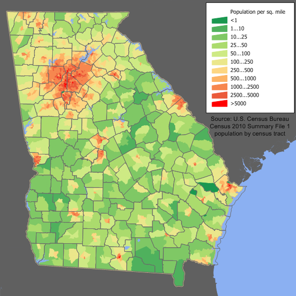
Georgia population map.png - JimIrwin

Gray's Reef NMS map.jpg - Werewombat

US State georgia grey.png - Wpgeek431
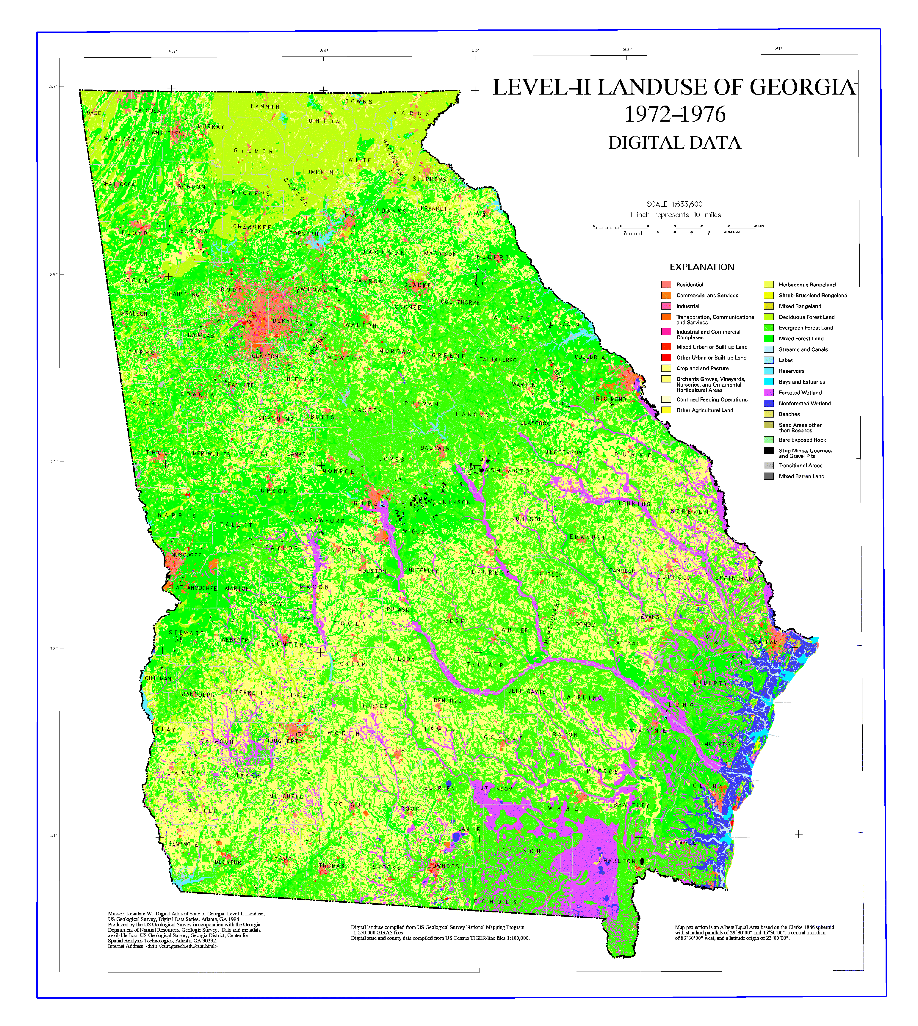
Georgia Landuse Map.png - File Upload Bot (Magnus Manske)

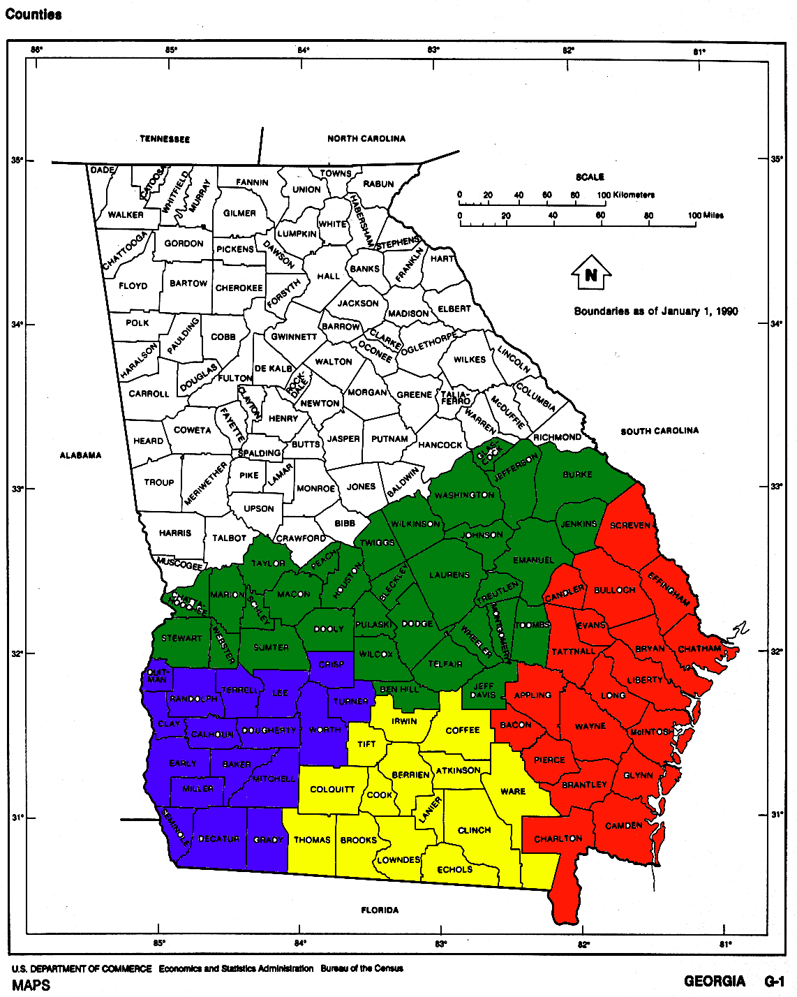
Georgia Counties.gif - Noddy
Southgeorgia.gif - Noddy

Kelleybarnesdammap.jpg - Sanorton
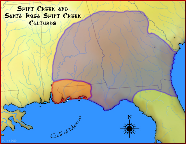
Swift Creek culture map HRoe 2010.jpg - Heironymous Rowe

PittsburghInSouthwestAtlanta.jpg - Keizers

OldFourthWardInEastCentralAtlanta.jpg - Keizers
GEFA Map.gif - GEFA-PA
Druid Hills CDP.pdf - Keizers

North Druid Hills.jpg - Keizers
Atlanta Central.png - Keizers

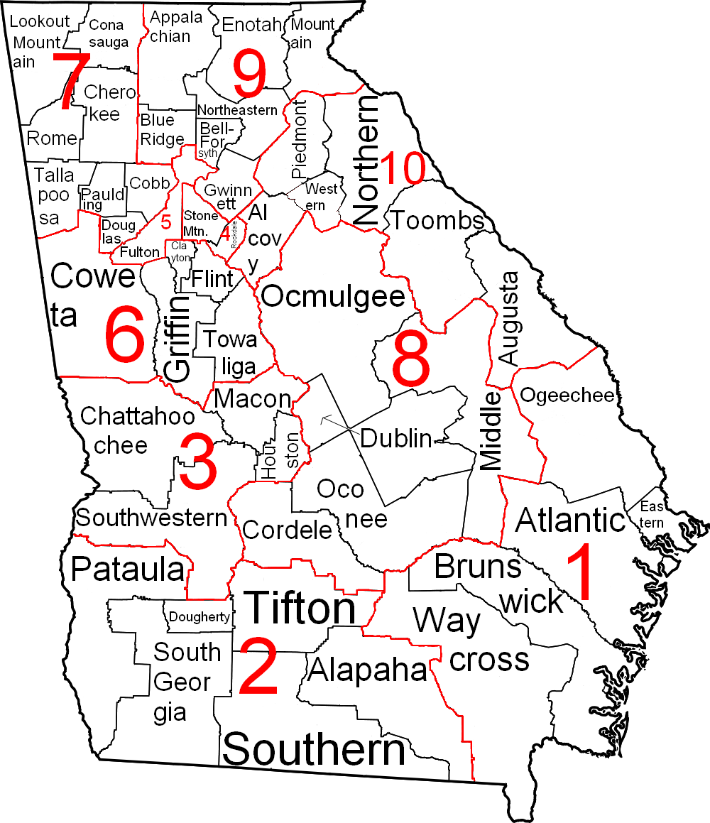
GDOT districts.png - Presidentman

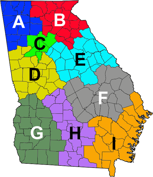
Regions of Georgia (U.S. state).png - Presidentman

Map of Georgia elevations.png - File Upload Bot (Magnus Manske)
GA - Troop Map.png - Ronhjones
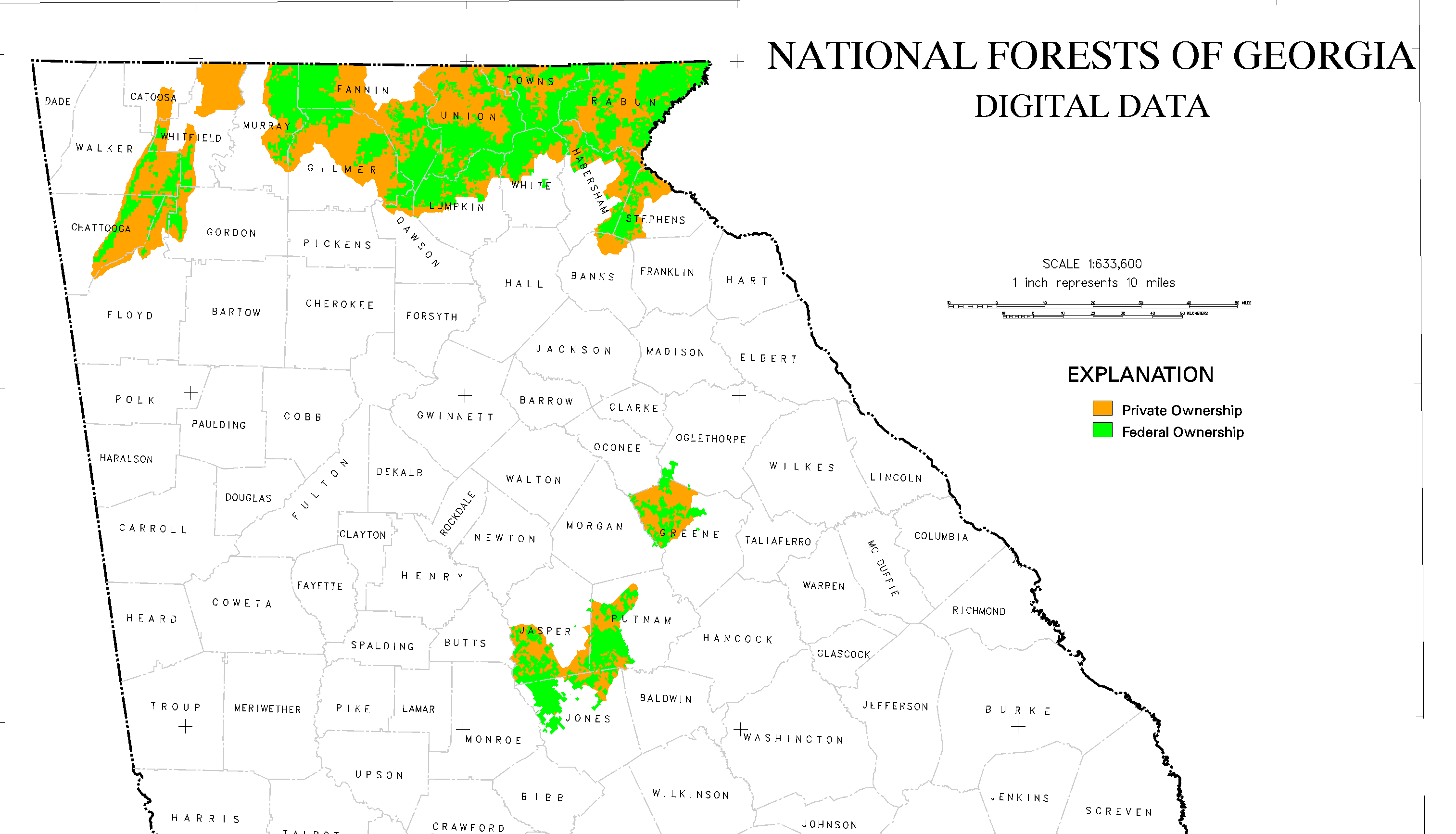
GA National Forest.png - Ronhjones

Southeast Georgia.png - TheRedPlanet447
Georgia-plantmaps-hardiness-zones.png - Ronhjones

Valdosta MSA.png - BotMultichillT
Georgia judicial districts and circuits map.png - Presidentman

Fort Walton and Leon-Jefferson cultures map HRoe 2012.jpg - Heironymous Rowe

Regions of Georgia.jpg - Renamed user j2lkj302803
Macon Bibb Consolidated Outline.png - Carlvlewis

Georgia 1845.jpg - National Public Domain Archive
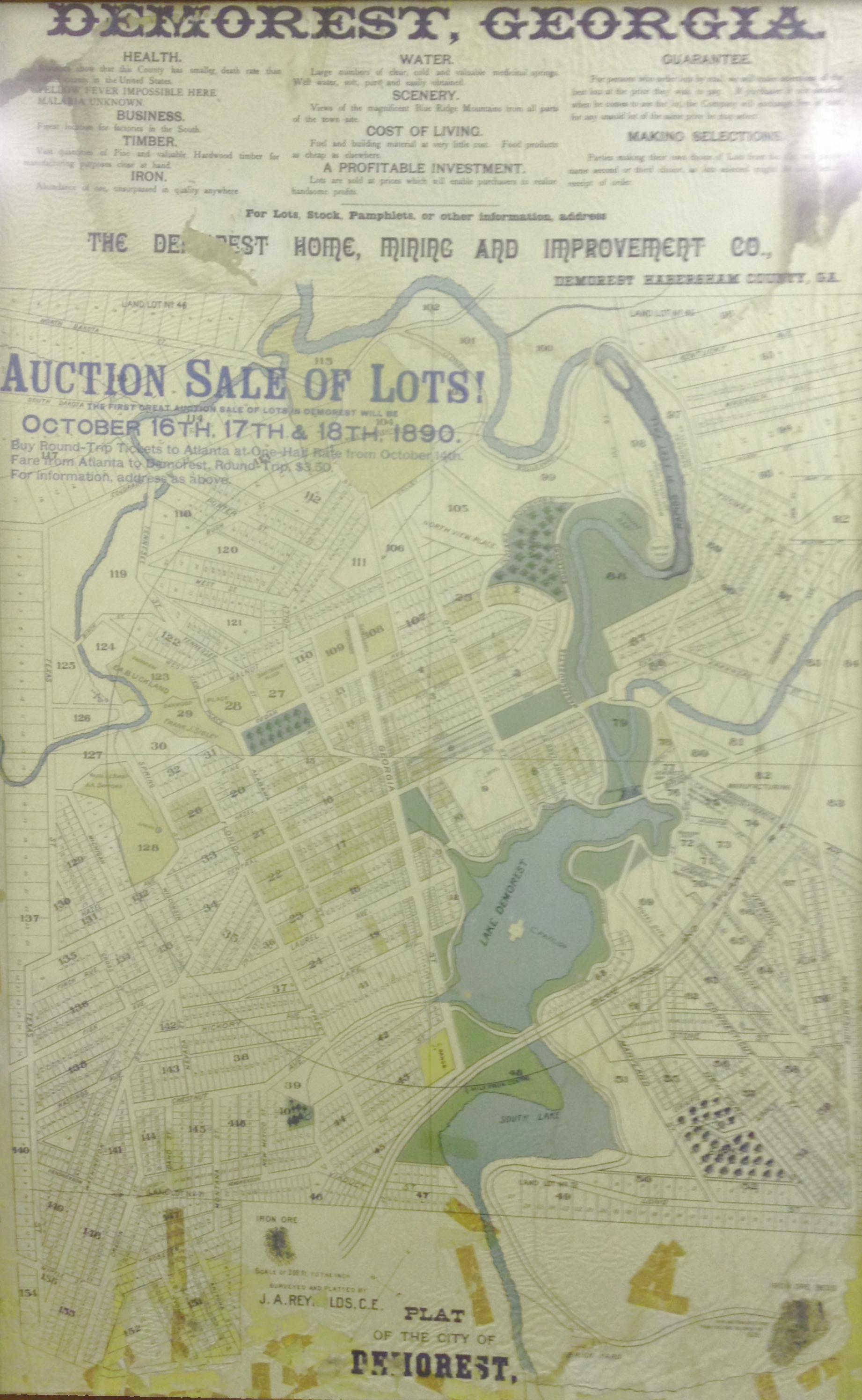
Demorest-Auction-Land-Plat-1890-restore.jpg - TLSuda

Demorest-Auction-Land-Plat-1890-original.jpg - TLSuda
Georgia ref 2001.jpg - File Upload Bot (Magnus Manske)
Georgia Congressional Districts 113th Congress-9th District-by county.tif - TFontaine
The Georgia Negro LCCN2013650424.jpg - Fæ

The Georgia Negro LCCN2013650425.jpg - Fæ

The Georgia Negro LCCN2013650439.jpg - Fæ

203433W sm.png - GifTagger

University of Georgia Campuses with Student Housing.gif - Alauzon
GeorgiaGoldBelt.jpg - Pi3.124

Advantages of Georgia for those desiring homes in a genial climate. 1906-7 (1907) (14595186189).jpg - Fæ

Bulletin (1922) (19802858393).jpg - Fæ

The history of Fuller's Ohio brigade, 1861-1865; its great march, with roster, portraits, battle maps and biographies (1909) (14760361904).jpg - Fæ

Wtty48dbu.JPG - Radiowarrior

Central Savannah River Area.png - TheRedPlanet447

South Georgia NRHP project progress.jpg - FastilyClone
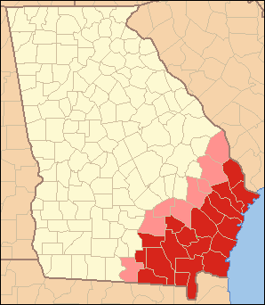
Map of Georgia, Lower Coastal Plain highlighted.png - FastilyClone
ElijahClarklocator.PNG - BD2412
Georgia Köppen.png - Redtitan
Map riverwalk3000.jpg - BD2412
Parish Map EDio of Atlanta.jpg - BD2412
Lyon Counties Georgia.png - OgreBot

January 2017 Georgia tornado outbreak.png - Cyclonebiskit

NWS Tallahassee Irma preliminary wind gusts.jpg - AHeneen

NWS Atlanta Irma rainfall totals in Georgia.jpg - AHeneen

NWS Atlanta Irma wind sustained vs gusts infographic.jpg - AHeneen

NWS Atlanta Irma wind gusts in Georgia.jpg - AHeneen

217 of 'Georgia- a guide to its cities, towns, scenery, and resources ... With illustrations' (11127222546).jpg - Artix Kreiger 2

Cgs05247 (9716175077).jpg - Artix Kreiger 2

Cgs05193 (9716272729).jpg - Artix Kreiger 2

Georgia counties NRHP June 2018.jpg - Bubba73

UpperSavannahRiverGA1795.jpg - Ajpolino

Columbus, Georgia Area.png - Columbusganative

G - NARA - 34381989 (page 2).jpg - US National Archives bot
Georgia Level IV ecoregions.pdf - TimK MSI
Georgia Level IV ecoregions small.pdf - TimK MSI

Georgia ancestry map.png - Mapsandfactsarefun
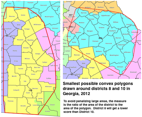
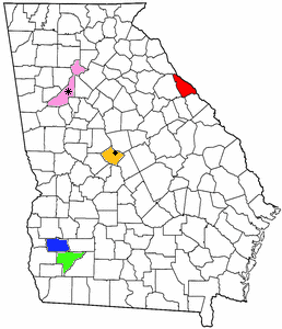
GeorgiaDistricts8and10.png - OsamaBinLogin

Chattahoochee National Forest, Brasstown-Chattooga-Chestatee-Cohutta-Tallulah-Toccoa-Ranger Districts-and Chattahoochee Purchase Unit, Georgia. LOC 75695958.jpg - Fæ

Russell-Brasstown National Scenic Byway - Russell-Brasstown Scenic Byway Bicycle Map - NARA - 7721459.jpg - US National Archives bot

Georgia - NARA - 26335498.jpg - US National Archives bot

Map of the State of Georgia - NARA - 78117044 (page 1).jpg - US National Archives bot

Map of the State of Georgia - NARA - 78117044 (page 2).jpg - US National Archives bot

Map of the State of Georgia - NARA - 78117044 (page 3).jpg - US National Archives bot

Map of the State of Georgia - NARA - 78117044 (page 4).jpg - US National Archives bot

Map of the State of Georgia - NARA - 78117670 (page 1).jpg - US National Archives bot

Map of the State of Georgia - NARA - 78117670 (page 2).jpg - US National Archives bot

Maconlocationbibbcounty.JPG - BD2412

Georgia 1865 county map with roads and railroads.png - Kwwhit5531

COVID-19 Georgia (state) by counties 2020-03-14.png - R. G. Checkers

COVID-19 Cases in Georgia (state) by counties, 2020-03-18.png - DividedFrame

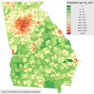
Georgia Population Density by Census Tract 2018.png - DoubleZ OTP

Georgia POI.png - Mpwood33

Personal Memoirs of Ulysses S. Grant Volume II (page 364 crop).jpg - SteinsplitterBot

GeorgiaSpeedLimitsMap.png - TyNoOutlet

Map of Georgia (US state).jpg - Zoozaz1

Physiographic provinces of Georgia and South Carolina (26846323091).jpg - Ltn12345
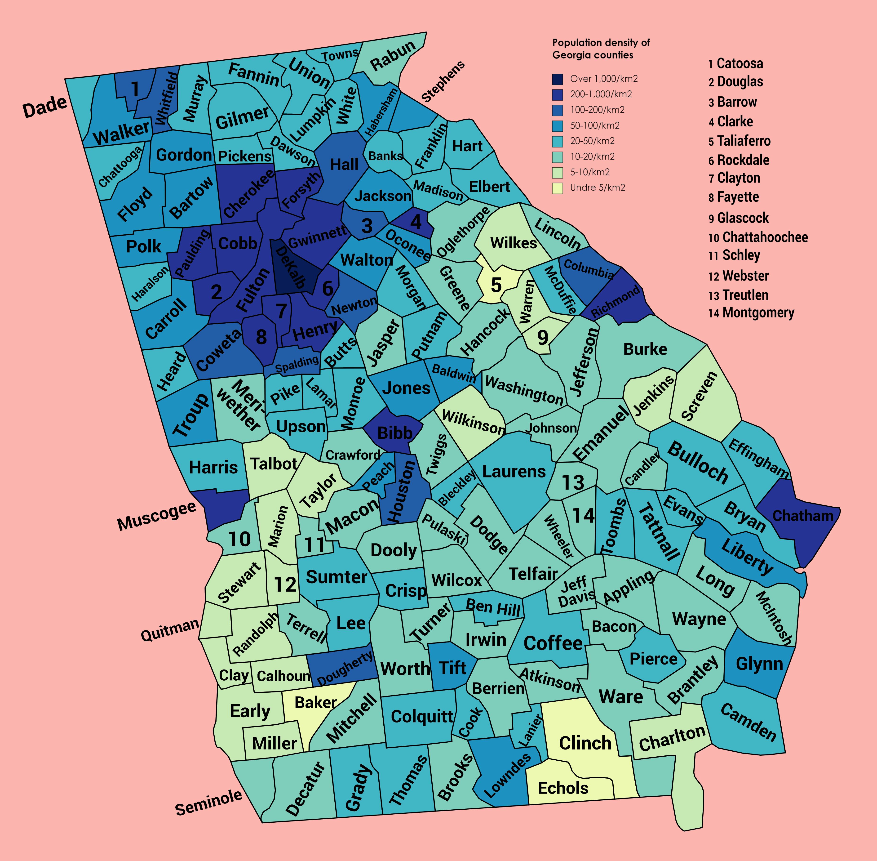
Population density of Georgia counties (2020).jpg - Austiger
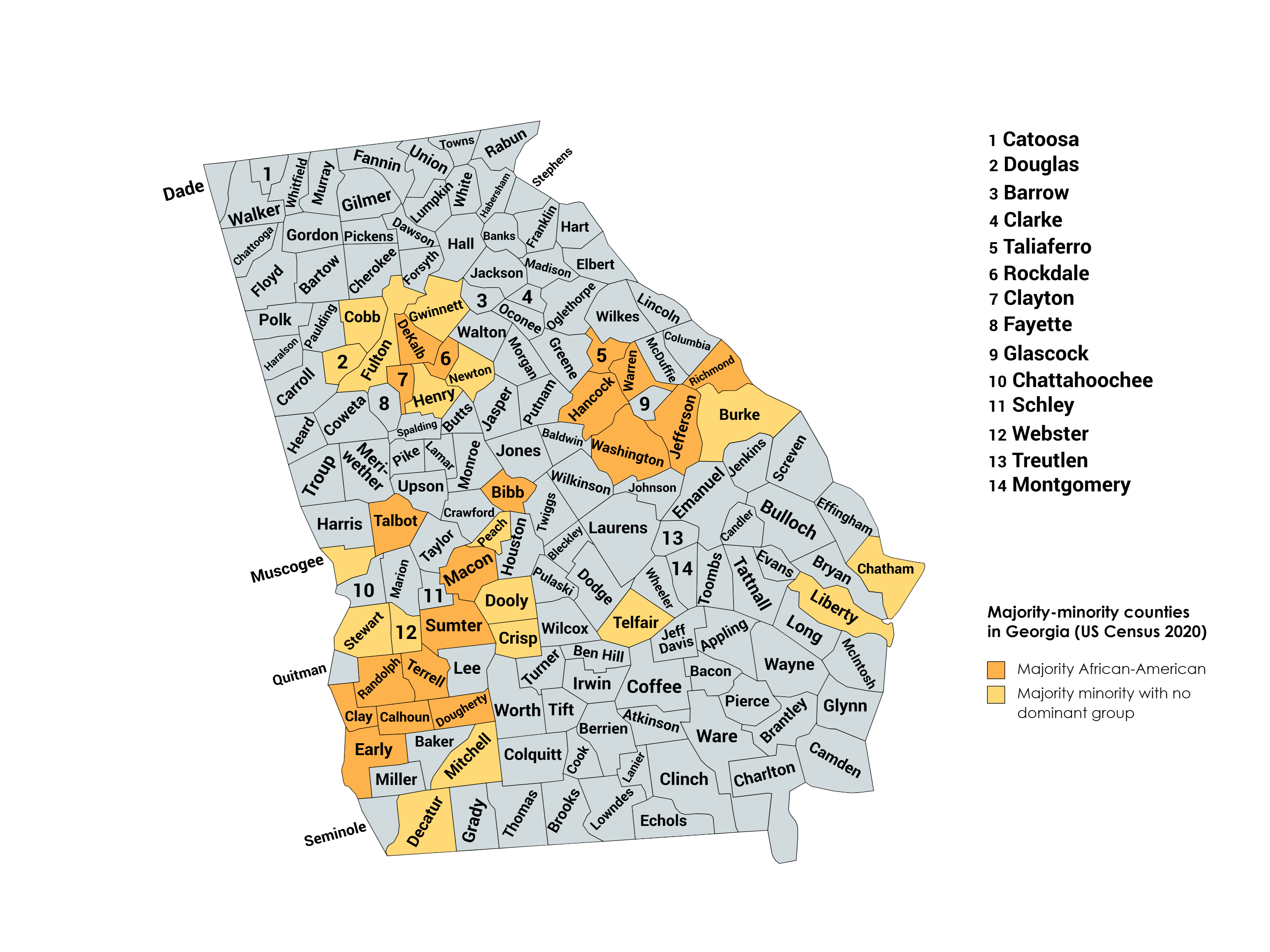
Majority minority counties in Georgia US Census 2020.png - Patapsco913

Athens GA Downtown Street Sign Map 1.jpg - Ivangiesen

Polygons of Georgia Districts 8 and 10.png - Belbury

Wvhy54.jpg - Radiowarrior

Wgsw48dbu.JPG - Radiowarrior

Yazoo-land-fraud-grants.webp - Cosma Seini

Distribution of various shell gorgets at Mound C,Etowah.JPG - Siyajkak

2022 GA-01.svg - DixiePolitics

2022 GA-08.svg - DixiePolitics

2016 GA-03.svg - DixiePolitics

2016 GA-04.svg - DixiePolitics

State of Georgia, with Chatham County highlighted, with dot showing where the cemetery is.png - Charlie Smith FDTB

Georgia Counties.png - MallardTV

Regions of Georgia (US state).png - TheLionHasSeen
Mirror Lake Highlighted inside the City of Villa Rica.pdf - Carrolleditor

Mirror Lake Highlighted.png - Carrolleditor
Villa Rica, GA.pdf - Carrolleditor

Georgia House District 81.png - Psnx74205

US Southeastern Plains Map.jpg - MiseDominic

US Southern Coastal Plain Map.jpg - MiseDominic

Range-map-of-hamiota-subangulata.png - Tokagelizard

Muscogee Creek Nation.jpg - Dacula1Resident

Map State of Georgia, USA, main roads with numbers, colored counties with names SVG.svg - Kirill Shrayber

Creation of Georgia Counties 1777-1932.jpg - Bubba73