Wikimedi'Òc
Modes d'emploi

Cet album fait partie des albums


Karte Haus Burgund 1.png - Sidonius

Karte Haus Burgund 2.png - DcoetzeeBot

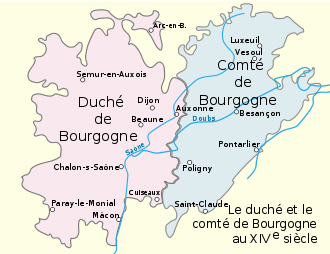
Duché et Comté de Bourgogne au XIVe siecle.svg - G CHP

Carte Etat bourguignon (Philippe le Hardi).svg - Hans Erren

Etat bourguignons.png - G CHP

Landgrafschaft Burgund.png - DcoetzeeBot

Duchy of Brabant and Duchy of Guelders (1350) locator map.svg - Sémhur

Carte Etat bourguignons 1-es.svg - Rowanwindwhistler

Duché et Comté de Bourgogne au XIVe siecle-es.svg - Rowanwindwhistler

Duché et Comté de Bourgogne au XIVe siecle-pt.svg - Renato de Carvalho Ferreira

Karte Haus Burgund 2-es.svg - Rowanwindwhistler

Burgundian State 1364-1404.svg - Arflhn

Flag map of the Duchy of Burgundy (918–1482).png - Szabolcsiandris

Karte-Haus-Burgund-FR.png - Sidonius

Duchy of Burgundy (XIV–XV centuries)-ka.svg - გიო ოქრო

C. 1350 Holy Roman Empire (Southwestern region).jpg - Ty's Commons

C. 1350 Burgundy and Savoy.jpg - Ty's Commons

C. 1350 Swiss region (Eidgenossen).jpg - Ty's Commons