Wikimedi'Òc
Modes d'emploi

Cet album fait partie des albums
Cet album photos contient les sous-albums suivants :


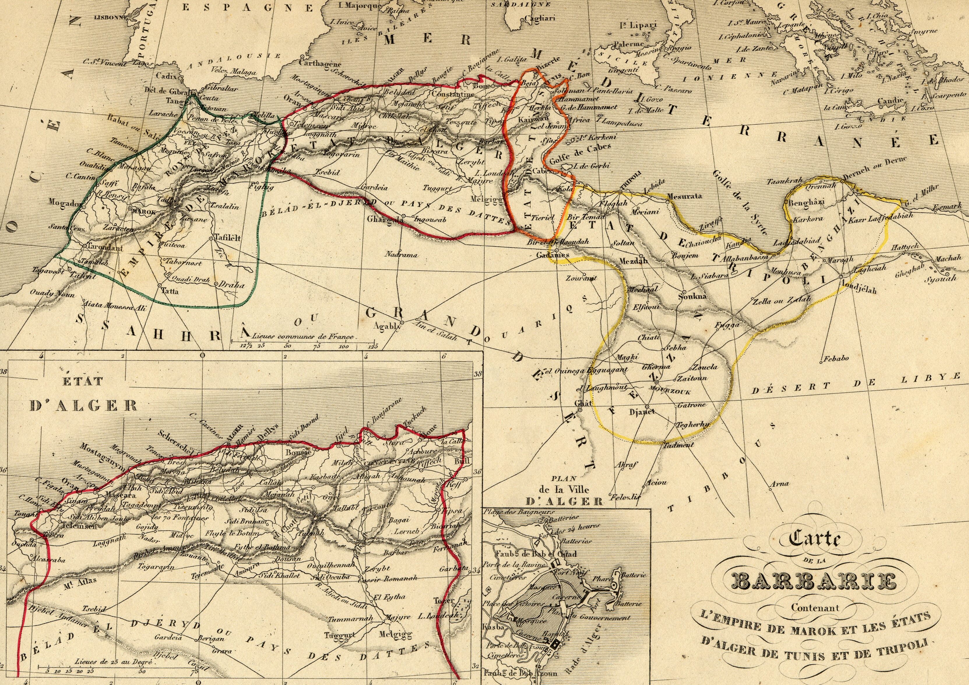
Carte Maghreb Vuillemin 1843.jpg - Dlebouc

Barbarie - 1806.jpg - DrFO.Jr.Tn

Map of Eastern Mediterranean. HM 34. PORTOLAN ATLAS, anonymous. France (?), ca. 1600.jpg - Geagea

Nautical chart of Mediterranean area, including Europe with British Isles and part of Scandinavia.Q.jpg - Geagea

Daniel Keller. Asiae nova descriptio (Antwerpen, 1590).LU9.jpg - Geagea

1780 Bonne Map of North Africa and the Western Mediterranean, Barbary Coast - Geographicus - BarbaryCoast-bonne-1780.jpg - BotMultichill

1833 Malte-Brun Map of North Africa or Barbary - Geographicus - AfricaNorth-mb-1837.jpg - BotMultichill

1829 Lapie Map of the Eastern Mediterranean, Morocco, and the Barbary Coast - Geographicus - Barbarie-lapie-1829.jpg - BotMultichillT

1829 Lapie Historical Map of the Barbary Coast in Ancient Roman Times - Geographicus - AfriquePropre-lapie-1843.jpg - BotMultichillT

1771 Bonne Map of the Mediterranean and the Maghreb or Barbary Coast - Geographicus - Barbarie-bonne-1771.jpg - BotMultichillT

1780 Raynal and Bonne Map of the Barbary Coast of Northern Africa - Geographicus - AfriqueBarbarie-bonne-1780.jpg - BotMultichillT

Africa North 1747, Emanuel Bowen (4006898-recto).jpg - Martin H.
Barbary coast3.jpg - Gwillhickers

1736 Oran detail West Part of Barbary map by Herman Moll BPL 14639.png - M2545

1736 Jaffa detail East Part of Barbary map by Herman Moll BPL 14639.png - M2545

The west part of Barbary containing Fez, Marocco, Algiers and Tunis ; East part of Barbary containing Tripoli, Barca and the north part of Egypt (5375430213).jpg - File Upload Bot (Magnus Manske)

1862 Johnson Map of Europe - Barbary Coast cutout.jpg - Enyavar
A chart of coast of BARBARY from C. Bajadore to the Golfe of St. Anne NYPL1640672.tiff - Fæ
A chart of the sea coast of ITALY, SICILY and part of BARBARY NYPL1640684.tiff - Fæ
Coast of Barbary from Tanger to Cape Bon; Coast of Barbary from Cape Bon to Damieta; Malta. NYPL1503449.tiff - Enyavar
The sea coast of BARBARY from cape de Tenes to cape de Rosa NYPL1640677.tiff - Fæ
Rigobert-Bonne-Atlas-de-toutes-les-parties-connues-du-globe-terrestre MG 0024.tif - Hansmuller

(1817) MAP OF THE BARBARY STATE.jpg - Metilsteiner

Map of part of the Mediterranean Sea from Malaga to the Island of Minorca (1803).png - CzarJobKhaya

Carte de la barbarie.png - LuzLuz31

Atlas Van der Hagen-KW1049B13 057-BARBARIA.jpeg - OlafJanssen
UBBasel Map Maghreb 1695 Kartenslg Mappe 252-33.tif - Basel University Library

The royal navy - a history from the earliest times to the present (1897) (14762849061).jpg - SteinsplitterBot

Travels, or, observations relating to several parts of Barbary and the Levant BHL20811388.jpg - Fæ

Travels, or, observations relating to several parts of Barbary and the Levant BHL20811477.jpg - SteinsplitterBot

Travels, or, observations relating to several parts of Barbary and the Levant BHL20811501.jpg - Fæ

Travels, or, observations relating to several parts of Barbary and the Levant BHL20811557.jpg - SteinsplitterBot

Bodleian Libraries, Portolan chart of the North Atlantic Ocean by John Burston.jpg - MartinPoulter

Map of Barbary by Abraham Ortelius.jpeg - File Upload Bot (Kaldari)

Barbary Coast 1590.jpg - Eastfarthingan

Coast of Barbary from Tanger to Cape Bon; Coast of Barbary from Cape Bon to Damieta; Malta (NYPL b14428893-1503449).jpg - Enyavar

A map of Barbary, containing the Kingdoms of Marocco, Fez, Algier, Tunis and Tripoli, with the adjacent countries (NYPL b13919861-5207431).jpg - Fæ

Map of Barbary (northern coast), 1683.jpg - Enyavar
The Fortified City of Oran on the Barbary Coast.png - Peripatesy

Barbary from Court Game of Geography MET DP862902.jpg - Pharos

Several voyages to Barbary Fleuron T184089-19.png - Fæ

Travels, or observations relating to several parts of Barbary and the Levant Fleuron T114689-12.png - Fæ

Travels, or observations relating to several parts of Barbary and the Levant Fleuron T114689-21.png - Fæ

Travels, or observations relating to several parts of Barbary and the Levant Fleuron T114689-23.png - Fæ

Travels, or observations relating to several parts of Barbary and the Levant Fleuron T114690-15.png - Fæ

Travels, or observations relating to several parts of Barbary and the Levant Fleuron T114690-32.png - Fæ

Travels, or observations relating to several parts of Barbary and the Levant Fleuron T114690-36.png - Fæ

Travels, or observations relating to several parts of Barbary and the Levant Fleuron T114688-5.png - Fæ

Travels, or observations relating to several parts of Barbary and the Levant Fleuron T114688-24.png - Fæ
Pas caart van de Middelandsche Zee RMG F8111.tiff - Fæ

Image taken from page 74 of 'A System of Geography, for the use of Schools. Illustrated with more than fifty cerographic maps, and numerous wood-cut engravings' (11227984424).jpg - Artix Kreiger 2

Image taken from page 74 of 'A System of Geography, for the use of Schools. Illustrated with more than fifty cerographic maps, and numerous wood-cut engravings' (16403120740).jpg - Artix Kreiger 2

A chart of the sea coast of Spain from Cape de Gata to Cape St Martin And of the Sea coast of Barbary and of the sea coa - Seller John The English Pilot - 1771.jpg - Gts-tg

A chart of the sea coast of Italy, Sicily and part of Barbary - Seller John The English Pilot - 1771.jpg - Gts-tg

The sea coast of Barbary, from cape Tenes to Cape Rosa - Seller John The English Pilot - 1771.jpg - Gts-tg

A chart of the sea coast of Spain from the Straights mouth to C de Gat, and of the sea coast of Barbary, from the Straig - Seller John The English Pilot - 1771.jpg - Gts-tg

A-3-37-15-Barbarie-Algeria.jpg - Poli.Pav

A-3-37-16-Barbarie-Tunis-Tripoli.jpg - Poli.Pav

Paskaart van een gedeelte van de Middellandse Zee met de kusten van Spanje en Algerije Paskaart voor een Gedeelte der Kust van Barbaria (titel op object), RP-P-1896-A-19368-3070.jpg - Mr.Nostalgic

Atlas Van der Hagen - Barbary Coast.jpeg - Chiswick Chap

1816 French map of the Barbary Coast.jpg - Balkanique
Eastern Sheet - Pas caart van de Middelandsche Zee RMG F8111 (cropped).tiff - Balkanique

La Geografia di Claudio Tolomeo Alessandrino, Tradotta di Greco nell'Idioma Volgare Italiano da Girolamo Russcelli (1598) 51.jpg - Balkanique

Atlante Veneto Volume 1 108.jpg - Balkanique

Gascoyne, Straights of Gibraltar.jpg - Ttocserp

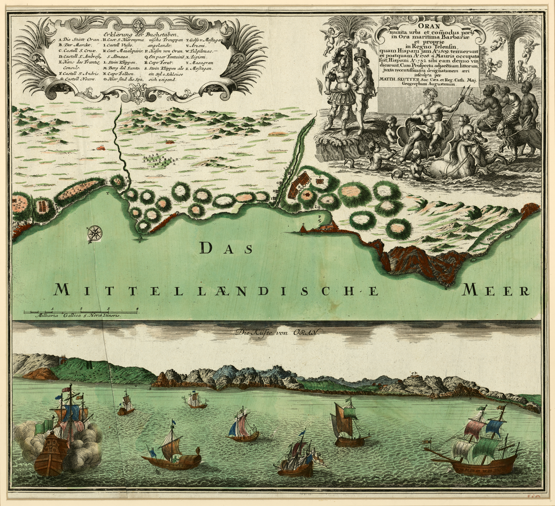
Wahrhaffte Abbildung der barbarischen Vestung Oran.jpg - Balkanique

Regency-of-Algiers-1824.jpg - Nourerrahmane
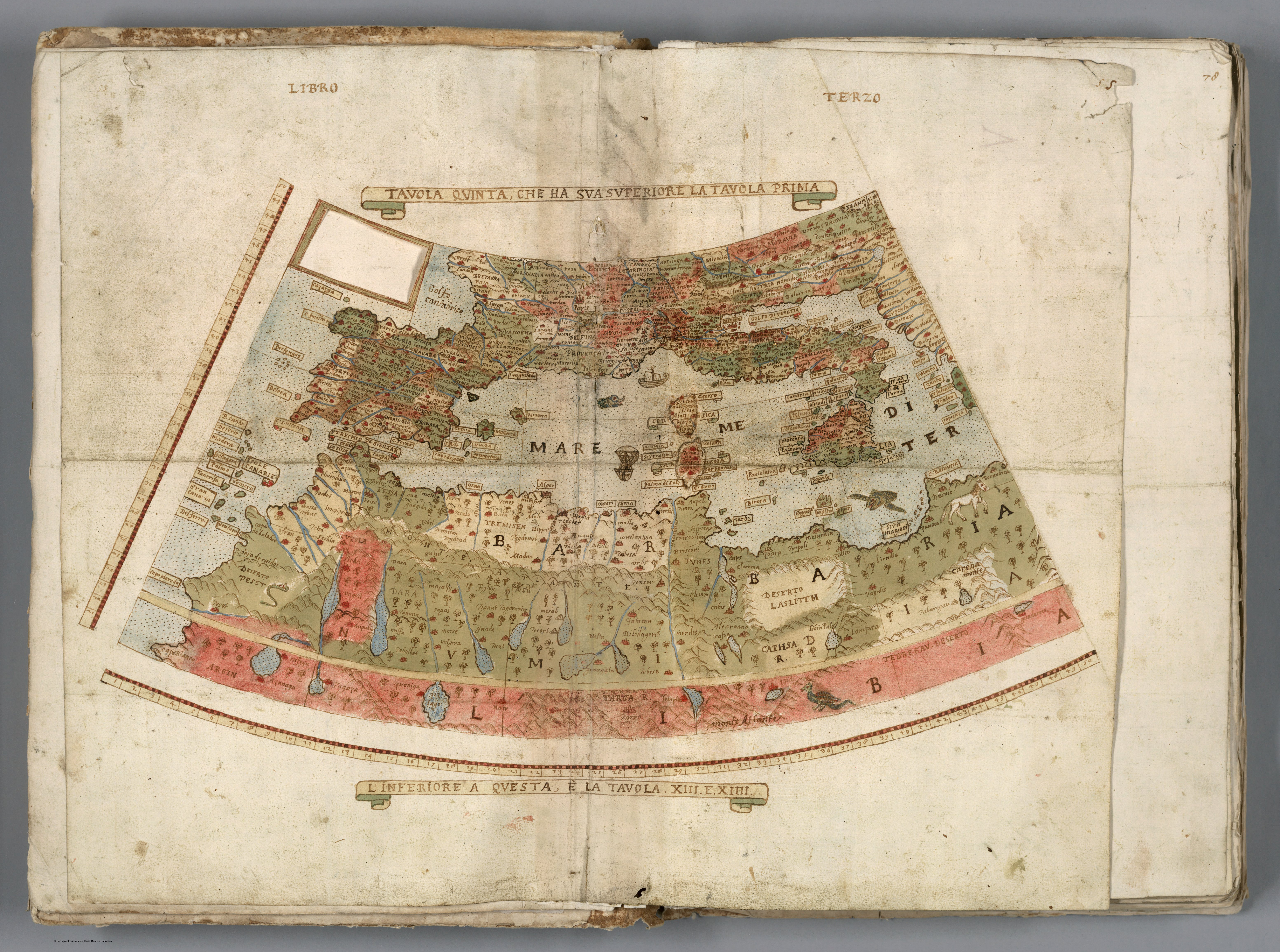
Tavola Quinta, Che Ha Sua Superiore La Tavola Prima. Libro Terzo. Urbano Monti (1587).jpg - One2

A-map-of-barbary-containing-the-kingdoms-of-marocco-fez-algier-tunis-and-tripoli-with-the-adjacent-countries-london--laurie-whittle.jpg - Hyytelö 2000

Mer Mediterranee Troisieme Feuille contenant La Moree, L'Archipel, Et les Costes de Romanie celles de Natolie, Caramanie, Syrie, Egypte, et Partie des Costes de Barbarie.jpg - Balkanique

Carte réduite des costes occidentales d'Afrique - première feuille contenant les costes de la Barbarie depuis le détroit de Gibraltar jusqu'au Cap Boja(dor) et les Isles Canaries, seconde feuille Depuis... - btv1b10678512f (1 of 2).jpg - Gzen92Bot

Carte particulière de la coste de Barbarie - Bremond - btv1b59055992 (1 of 2).jpg - Gzen92Bot

Carte de la partie de la côte de Barbarie comprise entre le cap Negro et le cap Bujarone - par M. le marquis de Chabert - btv1b53242309v (1 of 2).jpg - Gzen92Bot

Carte des côtes de Barbarie depuis le cap Bugaroni au royaume d'Alger jusqu'à la ville d'Africa ou Mahdia au royaume de Tunis... - par M. le marquis de Chabert... - btv1b532422850 (1 of 2).jpg - Gzen92Bot

Tabula portuum Barbariae, iunctis insuls Canariensibus - btv1b53196825f (1 of 2).jpg - Gzen92Bot

Tripoli - Citta di Barbaria cosi detta per essere edificata in memoria delle roine de tre città, Adrumento, Lepea, et Ruspina, (...) Novamente il Duca di Mendina Celi Vicere di Sicilia con l'Armata del Re... - btv1b53196819t (2 of 3).jpg - Enyavar

Plan géométrique de l'île de la Galita vers la côte de Barbarie - levé par le capitaine Lazare Giove d'Ajaccio... fini par J. B.te Adanson - btv1b53237600c (1 of 2).jpg - Gzen92Bot

Eigentliche Abbildung der Starken Vestung Larache ein furnhemer Meerhaven in Barbarien, welche, in Nahmen Königlicher Majest - von Hispanien durch den Marckgraven von S.Germein ist eingenomen worden A°... - btv1b8440776q (1 of 2).jpg - Gzen92Bot

Eigentliche Abbildung der Starken Vestung Larache ein furnhemer Meerhaven in Barbarien, welche, in Nahmen Königlicher Majest - von Hispanien durch den Marckgraven von S.Germein ist eingenomen worden A°... - btv1b8440776q (2 of 2).jpg - Gzen92Bot

Carte de la côte de Barbarie depuis le Cap Spartel jusqu'à Ste Croix et des côtes d'Espagne et de Portugal depuis Cadix jusqu'au Cap Sizimbre - dressée sur les observations faite en 1737 par l'escadre... - btv1b5905604x (1 of 2).jpg - Gzen92Bot

Les côtes de Barbarie - du cap Bon jusqu'à Bougie - btv1b53242275k (1 of 2).jpg - Gzen92Bot

A chart of the sea coasts of England...and part of Barbary - btv1b53009614s.jpg - Gzen92Bot

Plan de Portefarine en Barbarie... - par Albert, pilotte entretenu du Roy - btv1b532422996 (1 of 2).jpg - Gzen92Bot

Carte topographique de la coste de Barbarie, depuis Alger jusques a Tunis - btv1b532422761 (1 of 2).jpg - Gzen92Bot

Carte des côtes de Tripoly de Barbarie depuis le Cap Mesurat jusqu'à Sousse avec les bancs, roches et sondes... - dressée par François Olivier pilote sur ses observations de latitude faites dans sa campagne de... - btv1b84904747.jpg - Gzen92Bot

Plan des Isles Zafarines à la côte de Barbarie - btv1b59663785 (1 of 2).jpg - Gzen92Bot

Carta de la cote de Barbarie depuis le Cap Spartel jusqu'à St Croix et des côtes d'Espagne et de Portugal depuis Cadix jusqu'au cap Sizimbre, dressée sur les observations faites en 1737 par l'escadre... - btv1b7200842g (1 of 2).jpg - Gzen92Bot

Plan de la rade de Bizerte en Barbarie - par Albert, pilote entretenu du Roy - btv1b532423018 (1 of 2).jpg - Gzen92Bot

Les costes des royaumes de Fez, Alger, Tunis et Tripoli en Barbarie - par P. du Val, géographe du Roy ; F.D. Lapointe fecit - btv1b532422744 (1 of 2).jpg - Gzen92Bot

Plan de la ville et baye de Bonne a la coste de Barbarie - fait par Sarraire, pilote - btv1b532376223 (1 of 2).jpg - Gzen92Bot

Minute du plan d'Arzeu près d'Oran, côte de Barbarie - btv1b532423359 (1 of 2).jpg - Gzen92Bot

CARTE REDUITE DES COSTES OCCIDENTALES D'AFRIQUE Premiere Feuille contenant Les costes de Barbarie depuis le Detroit de Gibraltar jusqu'au Cap Bojador ET LES ISLES CANARIES - Dressée au Dépost des cartes... - btv1b5966433x (1 of 2).jpg - Gzen92Bot

Carte des côtes de Barbarie, comprenant les états de Maroc, Fez, Alger, Tunis et Tripoli... ; enrichie des plans des principales places et ports - gravé par E. Collin... - btv1b530937785.jpg - Gzen92Bot

Africae propriae tabula, in qua Punica regna uides, Tyrios et Agenoris urbem ; Sinus Carthaginensis - ex conatibus geographicis Abrahami Ortelii - btv1b59641019.jpg - Gzen92Bot

Carte de la partie de la côte de Barbarie comprise entre le cap Negro et le cap Bujarone - par M. le marquis de Chabert - btv1b53242308d (1 of 2).jpg - Gzen92Bot

2 cartes sur la même feuille - 1 A Chart of Y.e Coaft of BARBARY from Cape Geer to Cape Bajadore ; 2 A Chart of Y.e Coaft of BARBARY from C. Bajadore to the Golfe of St. Anne - Par Jeremy Seller et Charles... - btv1b5966417t (1 of 2).jpg - Gzen92Bot

PLAN DE LA GRANDE ISLE DE MOGODOR et ses Environs DE LA RADE DU CHATEAU ET DE LA NOUVELLE VILLE DE SUERA EN BARBARIE - btv1b59665086 (1 of 2).jpg - Gzen92Bot

Vüe de la ville et rade de Sousse en Barbarie - Le Moyne - btv1b53237552z (1 of 2).jpg - Gzen92Bot

Plan & Veüe des Isles Zaffarines En Barbaries - (Par) Henry Michelot - btv1b5966376b (1 of 2).jpg - Gzen92Bot

Carte de la partie de la côte de Barbarie comprise entre le cap Negro et le cap Bujarone - par M. le marquis de Chabert - btv1b53237617x (1 of 2).jpg - Gzen92Bot

Veüe de la place de la Calle en Barbarie... - par le Sr Jean Bigonnet... ; sous le com(m)andem(en)t de Mrs les directeurs généraux de la Compagnie des Indes - btv1b532375502 (1 of 2).jpg - Gzen92Bot

Plan géométrique de l'île de la Galita vers la côte de Barbarie - levé par le capitaine Lazare Giove d'Ajaccio... ; dessiné par B.my Benoist - btv1b53237601t (1 of 2).jpg - Gzen92Bot

Vüe de la ville de Sousse en Barbarie - btv1b53237553d (1 of 2).jpg - Gzen92Bot

Croquis d'une partie des côtes de Barbarie depuis le cap Bujarone jusqu'à la ville de Tunis - btv1b532422833 (1 of 2).jpg - Gzen92Bot

Nova Barbariae descriptio - btv1b531712105 (1 of 2).jpg - Gzen92Bot

La Barbarie, le Biledulgerid, le Zaara, la Nigritie, &c avec les isles au couchant d'Afrique - par P. Du-Val... ; R. Michault scripsit - btv1b53171209s (1 of 2).jpg - Gzen92Bot

Côtes de Barbarie, depuis le cap Bon jusqu'à Tenez, avec la pointe sud de la Sicile - btv1b53237558n (1 of 2).jpg - Gzen92Bot

Plan de Tripoli de Barbarie - envoié en 1752 à M. Rouillé par le Sr Martin - btv1b53235485g (1 of 2).jpg - Gzen92Bot

Carte de la côte du royaume de Tripoly de Barbarie - levée par le capitaine Martin Reboul - btv1b532354663 (1 of 2).jpg - Gzen92Bot

Carte de la côte de Barbarie, depuis le Cap Bon jusqu'à Tripoly - corrigée sur les observations faites par la frégatte du Roy le Zephire en 1742 - btv1b53237562c (1 of 2).jpg - Gzen92Bot

Veue du Cap Nègre - situé à la côte de Barbarie Royaume de Thunis - btv1b53237537c (1 of 2).jpg - Gzen92Bot

Carte des pays barbaresques du nord de l'Afrique - Afrique française et empire de Maroc pour servir à l'intelligence des opérations militaires et politiques de la France et de l'Espagne - dressée par A.... - btv1b53088205f.jpg - Gzen92Bot

Nova Barbariae descriptio - btv1b85953360 (1 of 2).jpg - Gzen92Bot

Côte du Bastion de France, depuis le cap de Rose jusques aux Gardes de Bizerte - btv1b53242307z (1 of 2).jpg - Gzen92Bot

Atlas de la Méditerranée - Petrus Collin - btv1b55007092q (06 of 17).jpg - Gzen92Bot

Atlas nautique de la Mer Méditerranée, de la Mer Noire et de l'Océan Atlantique nord-est Diegus Home cosmographus me fecit ano salutis 1559 - btv1b5901091s (05 of 15).jpg - Gzen92Bot

Carte de la côte de Barbarie, depuis le Cap Bon jusqu'à Tripoly - corrigée sur les observations faites par la frégatte du Roy le Zephire en 1742 - btv1b53237546b (1 of 2).jpg - Gzen92Bot

Atlas de la mer Méditerranée (Reprod. numérique) - par Brémond - btv1b53028104r (04 of 10).jpg - Gzen92Bot

Côte d'Espagne aux environs de Carthagène et les costes de Barbarie depuis le cap Falcon jusqu'à la baie d'Alger - H. de Leth fecit - btv1b53238426g (1 of 2).jpg - Gzen92Bot

Plan des Isles Zafarines a la coste de Barbarie - btv1b5966379k (1 of 2).jpg - Gzen92Bot

Deux cartes sur la même feuille - 1 De Cuft van Barbaryen van out Mamora tot C. Blanco ; 2 De Cuft van Barbaryen van C. Blanco tot C. de Geer - btv1b59664224 (1 of 2).jpg - Gzen92Bot

La Baÿe De Tanger En Barbarie - Henry Michelot - btv1b5966457b (1 of 2).jpg - Gzen92Bot

Tripoli de Barbarie - Gombaud - btv1b5905598n (1 of 2).jpg - Gzen92Bot

Vue de Tunis d'Alger and de Gigeri avec quelques particularitez curieuses touchant les moeurs de leurs habitans and de quelques autres pleuples de barbarie - (Henri Abraham Chatelain) - btv1b53143340j.jpg - Gzen92Bot

A Chart of the Coaft of BARBARIA with the Western, CANARIA, and CAPE DE VERD, ISLES - btv1b59664187 (1 of 2).jpg - Gzen92Bot

CARTE REDUITE DES COSTES OCCIDENTALES D'AFRIQUE Seconde Feuille Depuis le Cap Bojador Jusqu'a la riviere de Sierra Léona - POUR LE SERVICE DES VAISSEAUX DU ROY - Dréssée au Dépost des Cartes Plans et... - btv1b5966434b (1 of 2).jpg - Gzen92Bot

CARTE Reduite DES COTES OCCIDENTALES D'AFRIQUE Première feuille contenant Les Costes de Barbarie depuis le Détroit de Gigbraltar juqu'au Cap Bojador ET LES ISLES CANARIES - Chez Mr. Bellin Ingr. de la... - btv1b5966432h (1 of 2).jpg - Gzen92Bot

Paskaart voor een Gedeelte der Kust van Barbaria van C. Ivi tot Bona, ende Kust van Catalonia van Peniscola, tot Mataro, als mede de Eylanden Yvica, Majorca en Minorca ... - btv1b53053284n.jpg - Gzen92Bot

Côtes de Barbarie, depuis Bougie jusqu'à Bizerte - btv1b53237569h (1 of 2).jpg - Gzen92Bot

2 cartes sur la même feuille - 1 Chart of the Coaft of BARBARY from C. Spartel to C. Cantin ; 2 The Coaft of BARBARY From Cape Cantin to Cape Geer - Par Jeremy Seller et Charles Price - btv1b5966416d (1 of 2).jpg - Gzen92Bot

Plan des Albozènes dans le Royaume de Fez en Barbarie - btv1b59663963 (1 of 2).jpg - Gzen92Bot

Libya in the 1829 Lapie Map of the Eastern Mediterranean, Morocco, and the Barbary Coast - Geographicus - Barbarie-lapie-1829 (cropped).jpg - Onceinawhile

Libya in A Generall Mapp of the Coast of Barbarie, Where In Are The Kingdoms And Estates Of Morocco, Fez, Algier, Tunis and Tripolis (cropped).jpg - Onceinawhile

Libya in The west part of Barbary containing Fez, Marocco, Algiers and Tunis ; East part of Barbary containing Tripoli, Barca and the north part of Egypt (5375430213) (cropped).jpg - Onceinawhile

Barbary Coast on 1644 Europa Recens by Blaeu (cropped).jpg - Enyavar

EB1 Plate LXXXVIII.png - LlywelynII

Barbarie. Africae, Described. The manners of their Habits and buildings newly done into English by I.S (cropped).jpg - Geagea

Afrique Barbarie (1665 map detail).jpg - Enyavar
Pas caart van de Middelandsche Zee RMG F8111 (western part).tiff - Enyavar
Middel-landtsche Zee nieuwlix uytgegeven RMG F8095 (western part).tiff - Enyavar

Philipp Clüver, Mauritana et Africa Propria nunc Barbaria (FL13726071 2496059).jpg - Geagea

Joseph Roux, Carte de la Mer Mediterranée (FL13733986 3373960).jpg - Geagea

Le Coste di Barbaria (Antonio Zatta 1794, twelve small maps).jpg - Enyavar

Map of the Barbary Countries 17th Century.jpg - Aearthrise

Plan d'Oran a la coste de Barbarie, depuis la pointe de Canastel jusqu'à la Marse et la description du siège fait par les algériens l'année 1707 - btv1b532384306 (1 of 2).jpg - Gzen92Bot

Atlas d'Afrique ms. en 35 cartes - attribué à M. P. Briet, jésuite - btv1b550082364 (027 of 113).jpg - Enyavar

Atlas d'Afrique ms. en 35 cartes - attribué à M. P. Briet, jésuite - btv1b550082364 (029 of 113).jpg - Enyavar

A Chart of the Coaft of BARBARIA with the WESTERN, CANARIA, CAPE VERD, Isles - btv1b59664209.jpg - Gzen92Bot

A Chart of the Coaft of BARBARIA with the WESTERN, CANARIA, and CAPE VERD, Isles - btv1b5966419n.jpg - Gzen92Bot

Partie occidentale de l'Afrique ou se trouve la Barbarie divisée en royaumes de Maroc, de Fez, d'Alger, de Tripoli et de Tunis (et) le Sara ou le désert de Barbarie, la Nigrite ou le pais des Nègres et la... - btv1b10678510j.jpg - Gzen92Bot
Barbaria, et Biledulgerid. NYPL1632236.tiff - Fæ
Barbaria, et Biledulgerid. NYPL1632236 (cropped).tiff - Enyavar

A Generall Mapp of the Coast of Barbarie, Where In Are The Kingdoms And Estates Of Morocco, Fez, Algier, Tunis and Tripolis.jpg - Balkanique

Partie de la Barbarie, où est le royaume d'Alger ... partie du Biledulgerid ... - par N. Sanson - btv1b8595383n.jpg - Gzen92Bot

Partie de la Barbarie ou est le royaume d'Alger divisé en ses provinces. Partie du Biledulgerid ou sont Tegorarin, Zeb, etc, tirées de Sanuto et d'autres - par N. Sanson... ; I.S. Sculp. - btv1b8491223j.jpg - Gzen92Bot

Partie de Barbarie ou est le Royaume d'Alger divisé en ses Provinces Part du Biledulgerid, ou sont Tegovarin, Zeb &c. - DPLA - 65aba50526ea8a6f70284be1711bd5cd.jpg - DPLA bot

Description de l'univers (1683) (14781120781).jpg - Fæ

Partie de la Barbarie ou est le royaume d'Alger divisé en ses provinces. Partie du Biledulgerid sont Tegorarin, Zeb, etc. Tirées de Sanuto et d'autres - par N. Sanson d'Abbeville... ; I.S. sculp - btv1b84906938.jpg - Gzen92Bot

Barbaria, Biledulgerid, Numidia, Libyae exterioris pars septent - btv1b84912224.jpg - Gzen92Bot

Emanuel Bowen, A New and accurate map of the Western parts of Barbary. containing Fez, Morocco, Algiers, Tunis & Biledulgerid (FL13726059 2495215).jpg - Geagea

Lo stato presente di tutti i paesi volume XXVI 1766 (6107617).jpg - Polona Upload

Partie de la Barbarie ou est le royaume d'Alger divisé en ses provinces. Partie du Biledulgerid ou sont Tegorarin, Zeb, etc, tirées de Sanuto et d'autres - par N. Sanson... I.S. Sculp - btv1b8490692v.jpg - Gzen92Bot

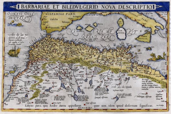
Barbariae et Biledulgerid, Nova Descriptio.jpg - Balkanique

Barbariae et Biledulgerid nova descriptio - btv1b85953397 (1 of 2).jpg - Gzen92Bot

Barbariae et Biledulgerid, nova descriptio - btv1b84919036.jpg - Gzen92Bot
Barbariae et Biledulgerid.jpg - Ezeu

Partie de la Barbarie ou est le royaume d'Alger divisé en ses provinces. Partie du Biledulgerid ou sont Tegorar in, Zeb, etc. tirées de Sanuto et d'autres - par N. Sanson... I.S. sculp - btv1b8491467d.jpg - Gzen92Bot

Barbaria Biledulgerid o- Libye et Pars Nigritarum Terra - DPLA - 6faeba597beb5e28b26a52dd1fda9228.jpg - DPLA bot

Barbaria Biledulgered o - Libye et pars Nigritarum Terra map.jpg - BrokenSphere

Barbaria, Biledulgerid o Libye et pars Nigritarum terra - btv1b84916035.jpg - Gzen92Bot

John Cowley Map of north Africa.jpg - Frukko