Wikimedi'Òc
Modes d'emploi

Cet album fait partie des albums
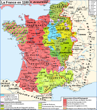


Map France 1180-fr.svg - ZigeunerAlt

Map France 1180-es.svg - Guilhemjoan

Aunis with Aquitaine.png - Thomas Gun

Map France 1180-de.svg - Furfur

Carte de l'Aunis.svg - Oie blanche

Aunis province.png - Oie blanche

Plan La Rochelle et environs, 1773, Nicolas Chalmandrier, BNF Gallica.jpg - Jebulon

Plans des ports de France (1777) - Ré-Olleron-Aunis.jpg - Ancalagon

Map France 1180-ru.svg - Vladimir Solovjev

Aunis in France (1789).svg - Milenioscuro

Plan of Rochfort & Rochel with the Islands of Res, Oleron, Aix, &c (BM 1871,1209.133).jpg - Copyfraud

Aunis.jpg - Ty's Commons

Map France 1180-uk.svg - Gzhegozh

Map France 1180-br.svg - Adriendelucca