Wikimedi'Òc
Modes d'emploi

Cet album fait partie des albums
Cet album photos contient les sous-albums suivants :


Map of Sendai Earthquake 2011.jpg - Heinz-Josef Lücking

Mar 11 11 12.16.40 UTC.gif - Orlovic

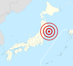
2011 Japan shakemap.jpg - Yacine Boussoufa
2011 Sendai earthquake.jpg - Stanqo
2011 Japan Sendai earthquake.jpg - Stanqo

JAPAN EARTHQUAKE 20110311.png - W.Rebel
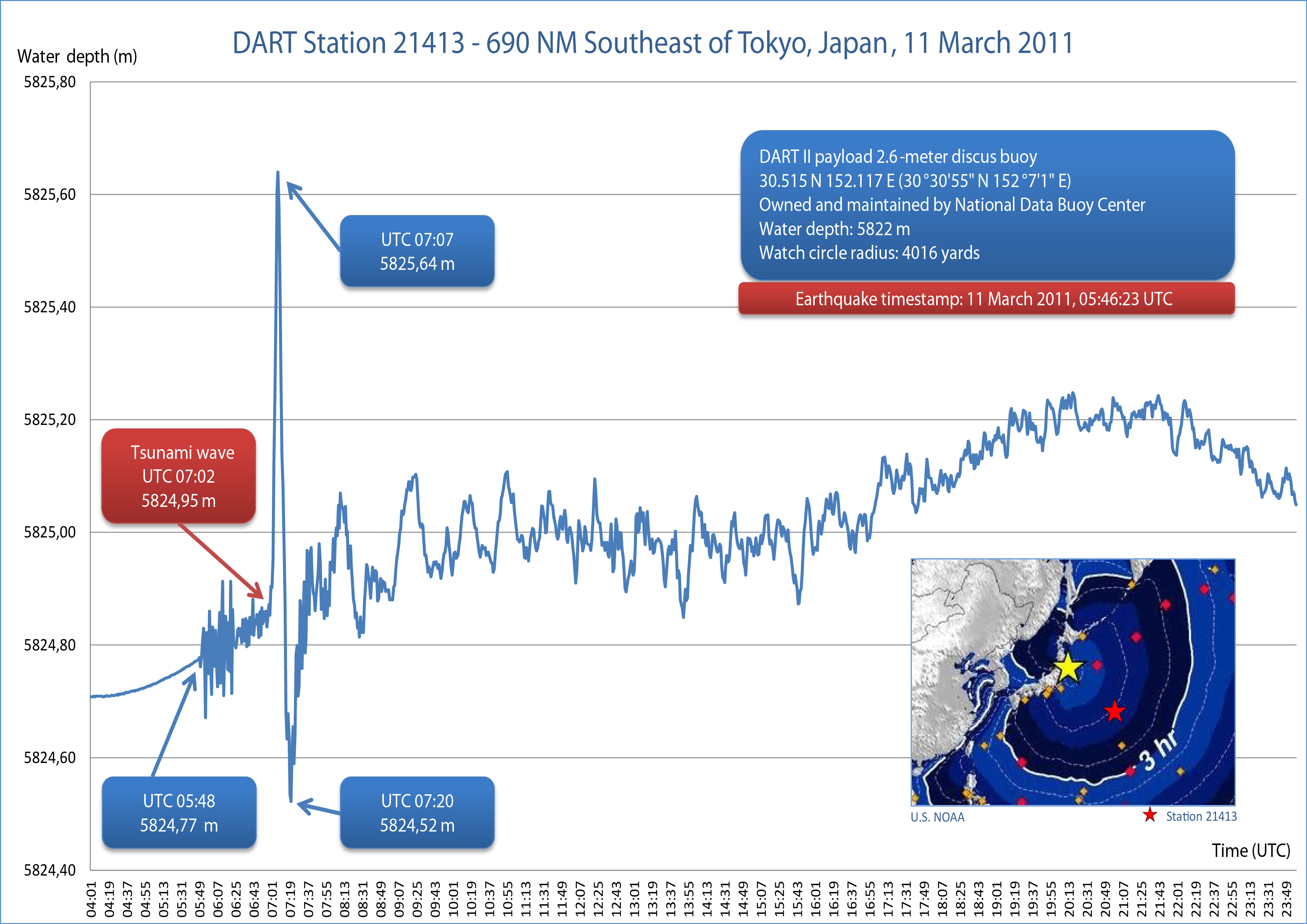
2011-Sendai-Tsunami-DART-21413-AB.png - Chepry

JAPAN EARTHQUAKE 20110311-de.png - NordNordWest
Wind Rain Prediction Fukushima Japan 20110314 12UTC.PNG - File Upload Bot (Magnus Manske)

JAPAN EARTHQUAKE 20110311-cs.png - Obankston
JAPAN EARTHQUAKE 20110311-rm.png - Obankston
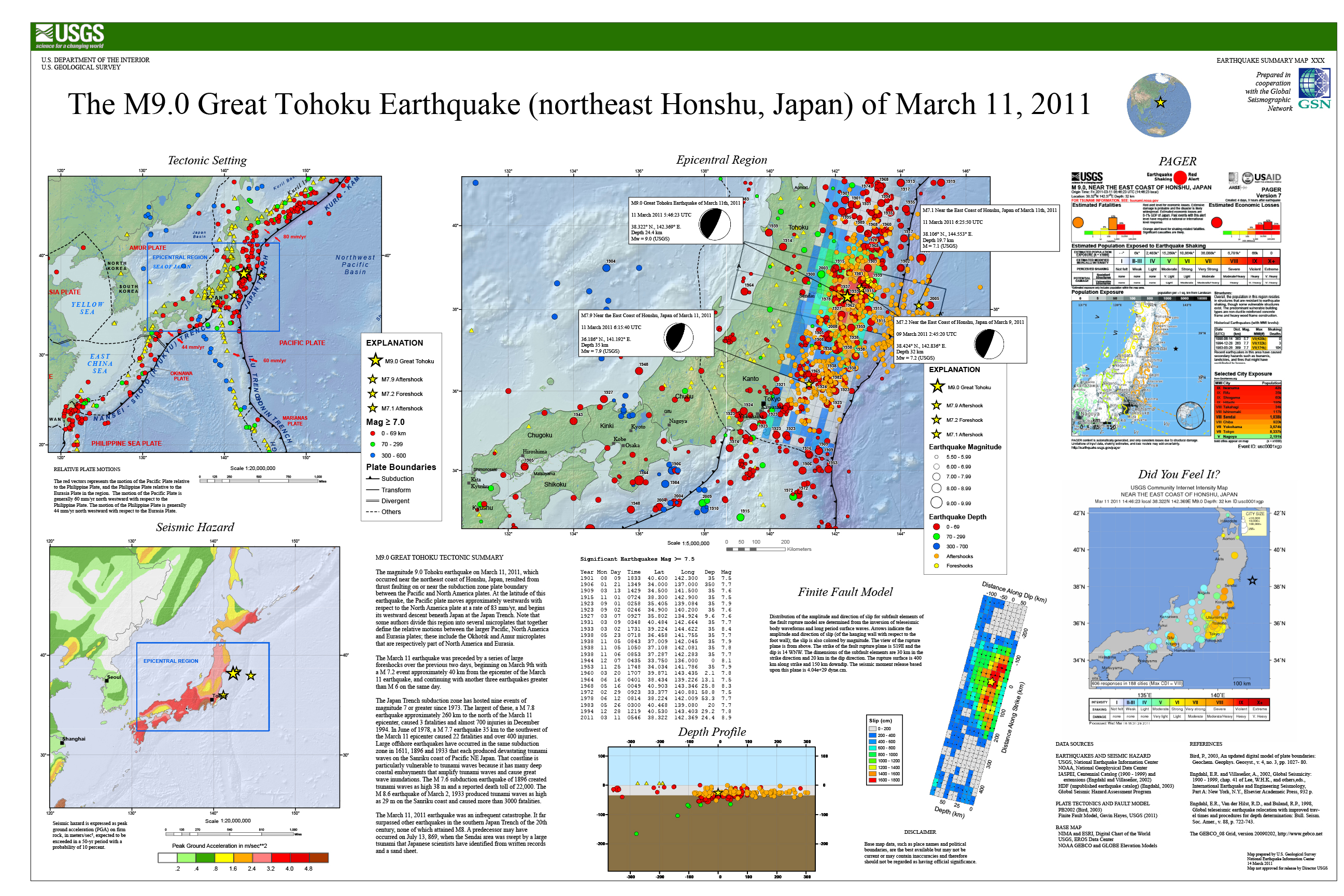
USGS-Poster-Tohoku Earthquake-20110311.jpg - Itu
USGS-Poster-Tohoku-Earthquake-20110311.pdf - Itu

Shindomap 2011-03-11 Tohoku earthquake.png - RokerHRO

Map of humanitarian support to the Great Eastern Japan Earthquake.svg - Kahusi

Techtonic of Tohoku region as 2011 earthquake.jpg - Pekachu

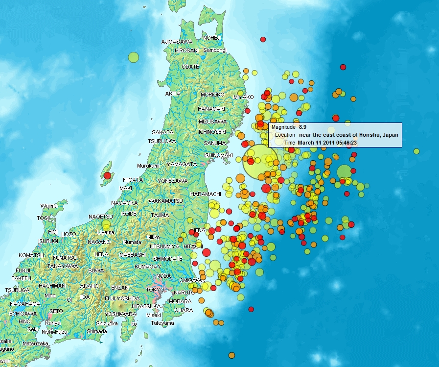
March112011earthquakeJapan.jpg - Wackywace

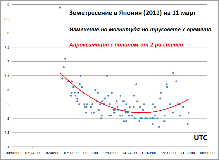
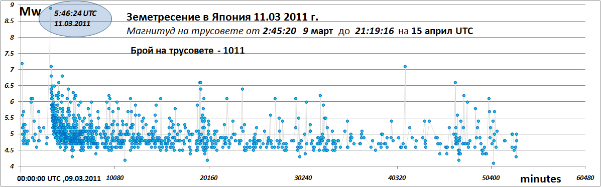
2011 Japan Sendai earthquake stat.jpg - Stanqo

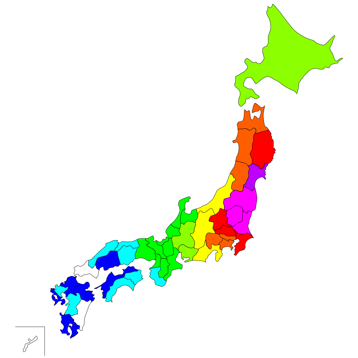
Deaths by prefecture from 2011 Tohoku Earthquake.jpg - CES1596

JAPAN EARTHQUAKE 20110311.svg - Kakan spelar

JAPAN EARTHQUAKE 20110311 es.svg - Victormoz

Deaths and missing persons by prefecture from 2011 Tohoku Earthquake.png - CES1596

2011 Tohoku earthquake mechanism main.png - Pekachu

JAPAN EARTHQUAKE 20110311-es.png - Rexmania

2011 Tohoku earthquake mechanism main en.png - Pekachu

2011 Tohoku earthquake intensity.png - As6022014

2011 Tohoku earthquake aftershocks 1year by JMA.png - Pekachu
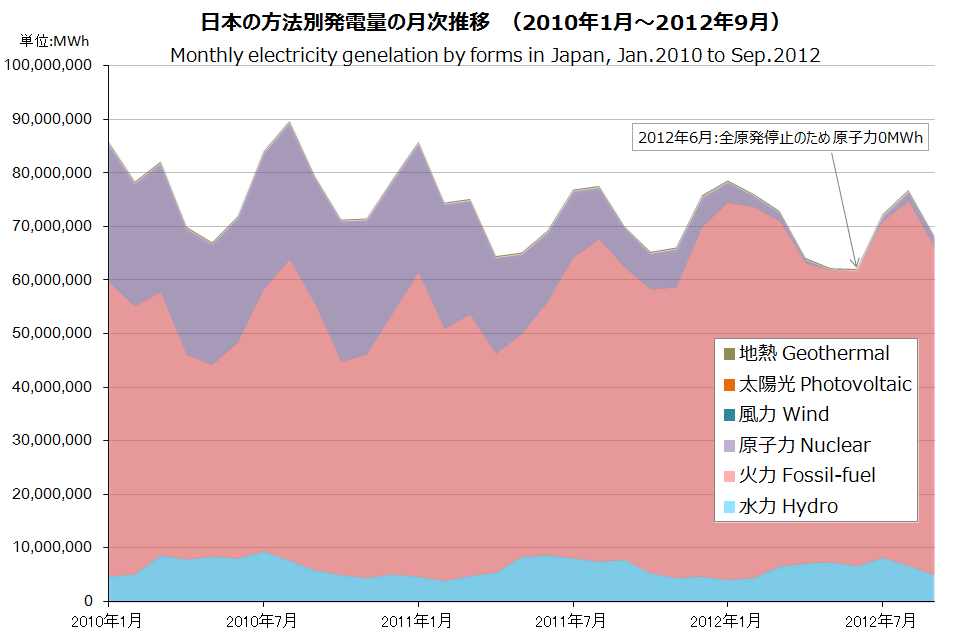
Japan electricity by forms.png - Pekachu

අප්රේල් 2011 ෆුකුෂිමා භූ චලනය.png - Dilan Asanga

145 40.png - GifTagger
145 40 smallglobe.png - GifTagger

A seismogram of 2011 Tōhoku earthquake and tsunami.jpg - Z22
C0001xgp wcmt smt.png - GifTagger

東日本大震災による火災の原因チャート画像.jpg - Japaninter031
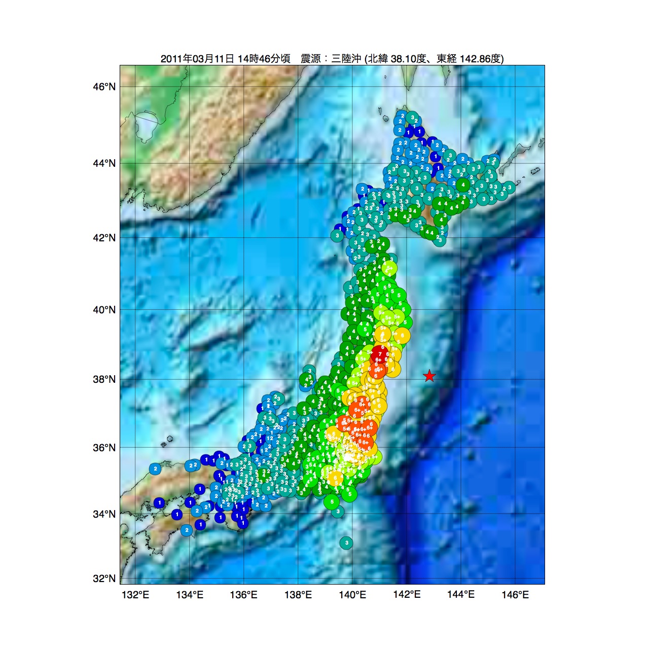
東日本大震災の震源マップ.jpg - Gtogk

2011 Tohoku earthquake Soil liquefaction map.png - Pekachu

Intensity of 2011 Tohoku earthquake Kurihara, Miyagi.svg - Pekachu

Intensity of 2011 Tohoku earthquake Chiyoda, Tokyo.svg - Pekachu
Sendai 2011 epicentre.png - CommonSupporter

2011 Tohoku earthquake mechanism main ko.png - IRTC1015

福島第一原子力発電所周辺の過去1年間の地震の震源分布と地殻変動.jpg - Gtogk

Heavy black plume of smoke streams southeast from Sendai, Japan (detail) (5519702076).jpg - A1Cafel

Earthquake and Tsunami near Sendai, Japan (5518346220).jpg - A1Cafel

GOES-11 Satellite Sees Pacific Ocean Basin After Japan Quake (5517505569).jpg - A1Cafel

Relationship between Run-up height inundation height and immersion depth in Japanese usage terms explained by FDMA and JWA.jpg - Anglo-Araneophilus~commonswiki

Sanriku-Erdbeben.jpg - Anglo-Araneophilus~commonswiki

Subsidence caused by the earthquake increased inundation risks.jpg - Anglo-Araneophilus~commonswiki

Sea defence structure terminology.jpg - Anglo-Araneophilus~commonswiki

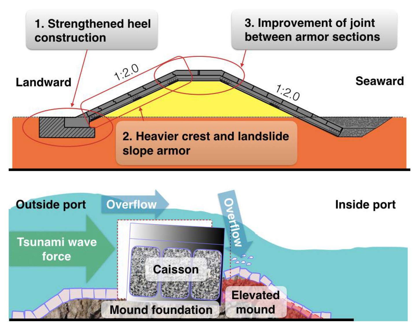
Structure of a highly resilient breakwater.jpg - Anglo-Araneophilus~commonswiki

Caisson breakwater section - former design and recommended design for a strong breakwater able to resist a tsunami beyond the design height.jpg - Anglo-Araneophilus~commonswiki

Lights of Japan before and after earthquake.jpg - A1Cafel

Average lights in Japan in 2010.jpg - A1Cafel

Lights in Japan after earthquake.jpg - A1Cafel

Forecasted fault segments on the plate interface near the Tohoku region.jpg - Anglo-Araneophilus~commonswiki

The characteristics of five overturned buildings in the town of Onagawa.jpg - Anglo-Araneophilus~commonswiki

Trends in (A) the modeled estimates of post-disaster population for those aged 6 years or older in Minamisoma City and (B) the ratio of estimated.jpg - Anglo-Araneophilus~commonswiki

Trends in (A) the modeled estimates of post-disaster population younger than 6 years in Minamisoma City and (B) the ratio of estimated population.jpg - Anglo-Araneophilus~commonswiki

Changes in gamma ray dose rate at a monitoring station near the Iitate Village hall.jpg - Anglo-Araneophilus~commonswiki

Triple disaster struck area in Minamisoma City photos were taken by Hui Zhang on 12 March 2014.png - Anglo-Araneophilus~commonswiki

Jaapani maavärin.png - Epp
Example of new coastal embankment and breakwater.jpg - Anglo-Araneophilus~commonswiki

Gap between people moving in and people moving out as a share of the population.jpg - Anglo-Araneophilus~commonswiki

Population decrease in disaster areas and survey of population and businesses in Minamisanriku - December 2011.jpg - Anglo-Araneophilus~commonswiki

Recovery concept of Minamisanriku Town.jpg - Anglo-Araneophilus~commonswiki
東北地方太平洋沖地震 都道府県ごとの震度.png - ヒースロー

110311-F-XX000-001 (5529492518).jpg - Ainz Ooal Gown

Super Asperity Model Map for the 2011 Off the Pacific Coast of Tohoku Earthquake.png - Twotwo2019

東北地方太平洋沖地震における長周期地震動階級.png - Artanisen

東北地方太平洋沖地震の震度分布(気象庁).png - Jombam

東日本大震災自衛隊災害派遣活動場所20111121.png - Crescent moon

東北地方太平洋沖地震による地殻変動(1).jpg - Sokiya

東北地方太平洋沖地震による地殻変動(2).jpg - Sokiya

2011年日本東北地方太平洋近海地震的JMA观测点烈度图.png - Qbulakema114
ShakeMap of The 2011 off the Pacific coast of Tohoku Earthquake.pdf - Qbulakema114