Wikimedi'Òc
Modes d'emploi

Cet album fait partie des albums
Cet album photos contient les sous-albums suivants :


USA Jefferson, Oregon age pyramid.svg - DieBucheBot

Olallielakemtjefferson.jpg - Utopies
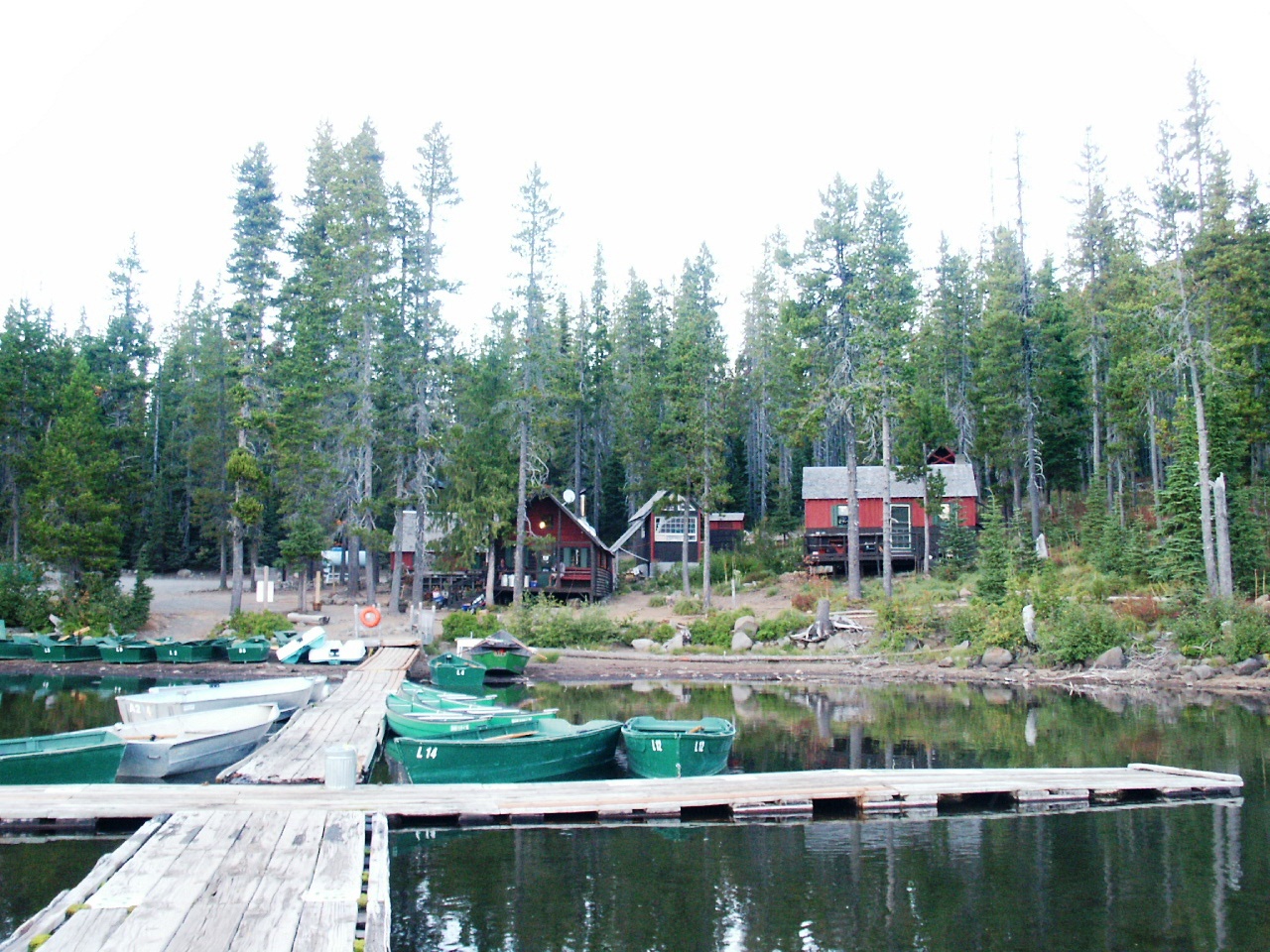
Olallie Lake Resort.JPG - Aboutmovies

Warm Springs map2.png - Peteforsyth

Warm Springs Indian Reservation.JPG - Mat783

Trout Creek Watershed.png - Little Mountain 5

Satellite image of B&B Complex Fires, 24 Aug 03 1.jpg - Orygun

B&B Burn Near Three Fingered Jack, Oregon Cascades 1.jpg - Vantey

Tam-a-lau Trail Flower (Jefferson County, Oregon scenic images) (jefDB1385).jpg - Smallbot

Smoke and fire as seen from U.S. 26 (6096900833).jpg - File Upload Bot (Magnus Manske)

Jefferson County Exhibit, Oregon State Fair (5833601733).jpg - File Upload Bot (Magnus Manske)

Corbett State Park sign.JPG - Orygun
Olallie Butte top (cropped).jpg - Droll

Oregon Army National Guard citizen-soldiers support multiple agency fire suppression efforts 140721-Z-PL933-083.jpg - Fæ

Three Fingered Jack BB 150509.jpg - Johnny.m76

Hood Jeff ThreeFingeredJack BB 150509.jpg - Johnny.m76

Settlements South of Lake Billy Chinook, Oregon (1290986485).jpg - INeverCry

Madras Livestock Auction Market-02.jpg - Tequask

Madras Livestock Auction Market-01.jpg - Tequask
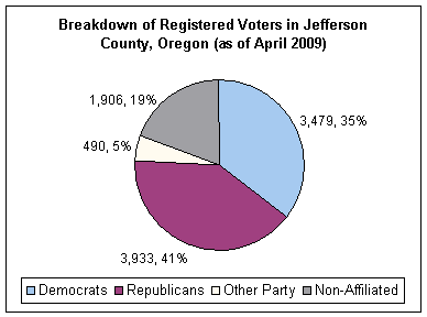
Political orientations in Jefferson County, Oregon (2009).gif - Kingofthedead

140720-Z-PL993-100 (14550213639).jpg - Vanished Account Byeznhpyxeuztibuo

Thundereggs - panoramio.jpg - Panoramio upload bot

Rimrock - panoramio.jpg - Panoramio upload bot

Red on deschutes - panoramio.jpg - Panoramio upload bot

Warm Springs 4-H members get training (5857943719).jpg - Fæ
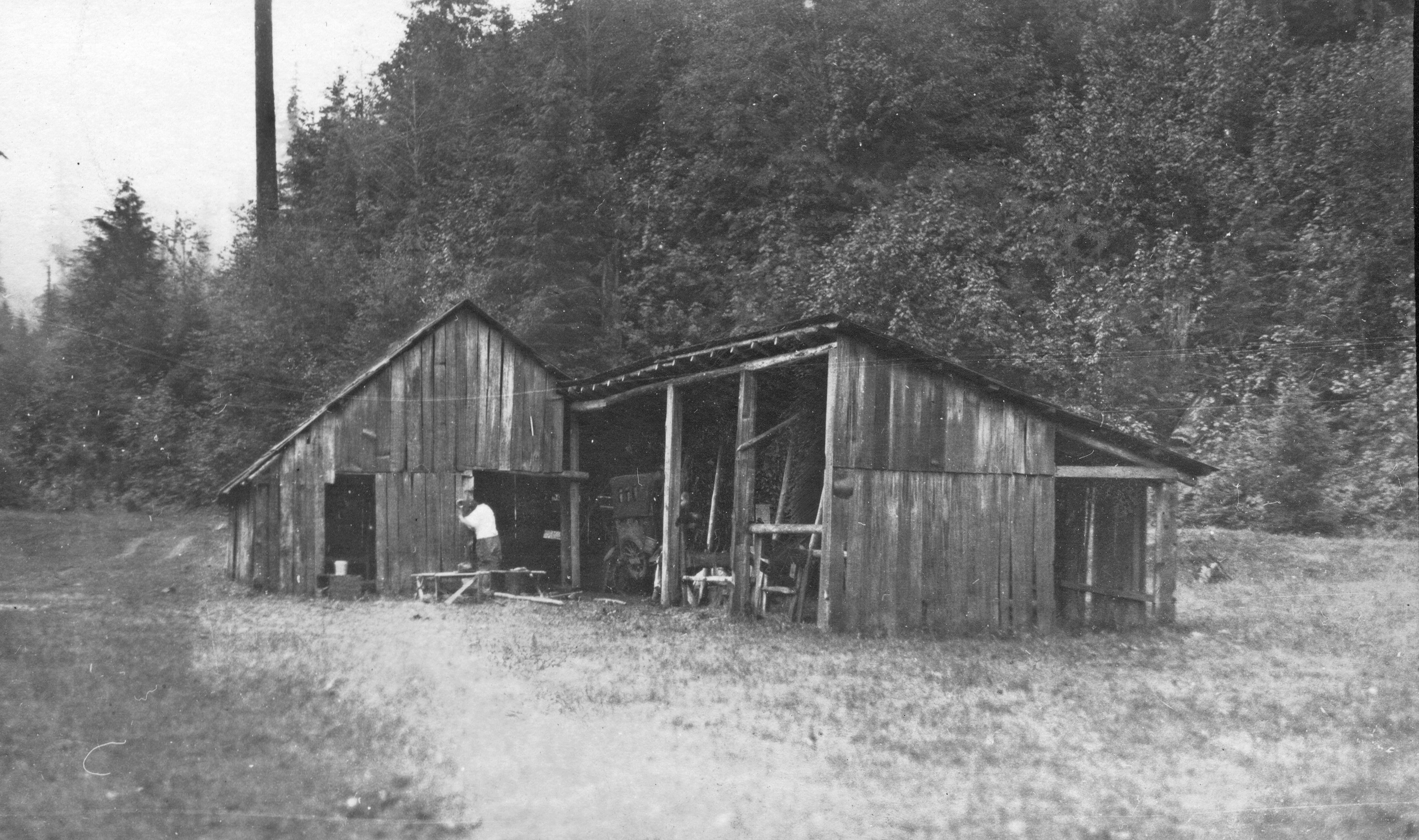
Barn of the "Half-way House", Santiam Pass, Oregon (3385595697).jpg - Fæ

Crooked River Canyon (3385598995).jpg - Fæ

Jefferson County, OR, USA - panoramio.jpg - Panoramio upload bot

Jefferson County, OR, USA - panoramio (1).jpg - Panoramio upload bot

Jefferson County, OR, USA - panoramio (2).jpg - Panoramio upload bot

Jefferson County, OR, USA - panoramio (3).jpg - Panoramio upload bot

Jefferson County, OR, USA - panoramio (4).jpg - Panoramio upload bot

Jefferson County, OR, USA - panoramio (5).jpg - Panoramio upload bot

Jefferson County, OR, USA - panoramio (6).jpg - Panoramio upload bot

Jefferson County, OR, USA - panoramio (8).jpg - Panoramio upload bot

Jefferson County, OR, USA - panoramio (9).jpg - Panoramio upload bot

Jefferson County, OR, USA - panoramio (10).jpg - Panoramio upload bot

A look up into the treetop - panoramio.jpg - Panoramio upload bot

Jefferson County, OR, USA - panoramio (11).jpg - Panoramio upload bot

Jefferson County, OR, USA - panoramio (12).jpg - Panoramio upload bot

Cool of the shade - panoramio.jpg - Panoramio upload bot

Refletctions - panoramio.jpg - Panoramio upload bot

Summer fun on the water - panoramio.jpg - Panoramio upload bot

Dark Lake, Oregon.jpg - Icetsarina

2017-08-18 Jefferson County eclipse camp 01.jpg - Kingofthedead

2017-08-18 Jefferson County eclipse camp 02.jpg - Kingofthedead

2017-08-18 Jefferson County eclipse camp 04.jpg - Kingofthedead

2017-08-18 Jefferson County eclipse camp 03.jpg - Kingofthedead

2017-08-18 Jefferson County eclipse camp 05.jpg - Kingofthedead

2017-08-18 Jefferson County Route 97.jpg - Kingofthedead

The Forests Of Jefferson (234644161).jpeg - Rodrigo.Argenton

Mount Jefferson (as seen from Warm Springs Reservation).jpg - Andy8Kahn

Central Oregon 2017 01.jpg - Dirtsc

Central Oregon 2017 02.jpg - Dirtsc

Lower right detail, Oregon Thundereggs - panoramio (cropped).jpg - Tibet Nation

033022 metolious wolf odfw 4x5 (52020023803).jpg - Jarble

Irrigation modernization (9303).jpg - Jason.nlw

Black Butte Trail - DPLA - a72d112e9395e05127e2fa36f6a9ca7c.jpg - DPLA bot

Lake Simtustus, Oregon - Flickr - Bonnie Moreland (free images).jpg - Red panda bot

Deschutes Canyon - Steelhead Falls WSA (33269069462).jpg - OceanAtoll

Deschutes Canyon WSA (33041777620).jpg - OceanAtoll