Wikimedi'Òc
Modes d'emploi

Cet album fait partie des albums
Cet album photos contient les sous-albums suivants :


Trig Point on Holyhead Mountain - geograph.org.uk - 7375757.jpg - GeographBot

An ascending path - geograph.org.uk - 899352.jpg - GeographBot

Former quarry at Holyhead Mountain - geograph.org.uk - 7156366.jpg - GeographBot

Stone wall on Holyhead Mountain - geograph.org.uk - 7156368.jpg - GeographBot

Stone wall on Holyhead Mountain - geograph.org.uk - 7156874.jpg - GeographBot

Stone Wall on Holyhead Mountain - geograph.org.uk - 7157752.jpg - GeographBot

Trig point on Holyhead Mountain - geograph.org.uk - 7157060.jpg - GeographBot

Trig point on Holyhead Mountain - geograph.org.uk - 7157062.jpg - GeographBot

Trig point on Holyhead Mountain - geograph.org.uk - 7157064.jpg - GeographBot

Holyhead Mountain Trig Point - geograph.org.uk - 10549.jpg - GeographBot

Holyheadmountain.jpg - File Upload Bot (Magnus Manske)

Holyhead, the Mountain and the Breakwater. - geograph.org.uk - 363805.jpg - GeographBot

Holyhead Mountain at twilight - geograph.org.uk - 402263.jpg - GeographBot

North Stack island from Holyhead Mountain - geograph.org.uk - 468941.jpg - GeographBot

View along the track in the direction of the quarry on Holyhead Mountain - geograph.org.uk - 876742.jpg - GeographBot

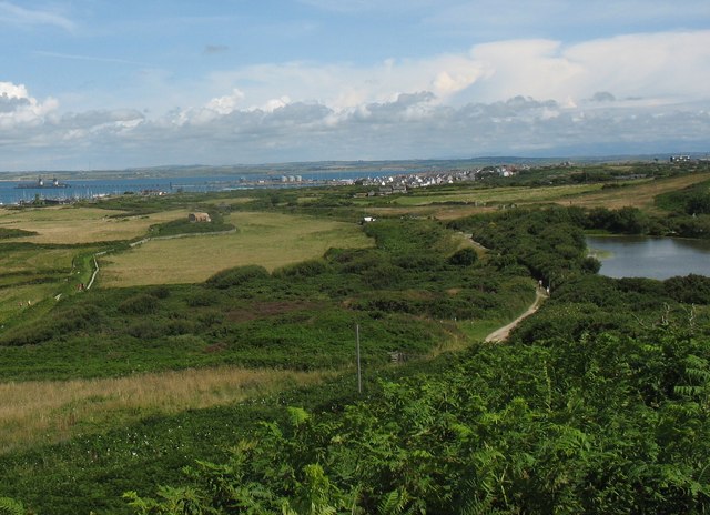
View westwards across a harvested meadow with Holyhead Mountain in the background - geograph.org.uk - 876626.jpg - GeographBot

A top section of the quarry face - geograph.org.uk - 898678.jpg - GeographBot

An old steam boiler at the top of the quarry - geograph.org.uk - 895796.jpg - GeographBot

Bracken infested eastern slope of Holyhead Mountain - geograph.org.uk - 895803.jpg - GeographBot

Brickworks chimney from the top of the quarry - geograph.org.uk - 895790.jpg - GeographBot

Clad in Imperial purple - the eastern slopes of Mynydd Twr - geograph.org.uk - 898768.jpg - GeographBot

Crags on the northern side of the Mynydd Twr summit - geograph.org.uk - 899345.jpg - GeographBot

Heather and boulders on the middle slopes of Mynydd Twr - geograph.org.uk - 898775.jpg - GeographBot

Minutes from Chester - geograph.org.uk - 898810.jpg - GeographBot

Path descending south-westwards from the summit - geograph.org.uk - 899331.jpg - GeographBot

Paths descending from Mynydd Twr - geograph.org.uk - 899355.jpg - GeographBot

Porth Namarch - geograph.org.uk - 898762.jpg - GeographBot

The "lowlands" east of Holyhead Mountain - geograph.org.uk - 898725.jpg - GeographBot

The final scramble to the summit of Mynydd Twr - geograph.org.uk - 899236.jpg - GeographBot

The northern section of the Breakwater Quarries - geograph.org.uk - 898713.jpg - GeographBot

The plateau area west of Mynydd Twr - geograph.org.uk - 898800.jpg - GeographBot

The road to South Stack - geograph.org.uk - 898754.jpg - GeographBot

The stepped path to "Spaghetti Junction" - geograph.org.uk - 899690.jpg - GeographBot

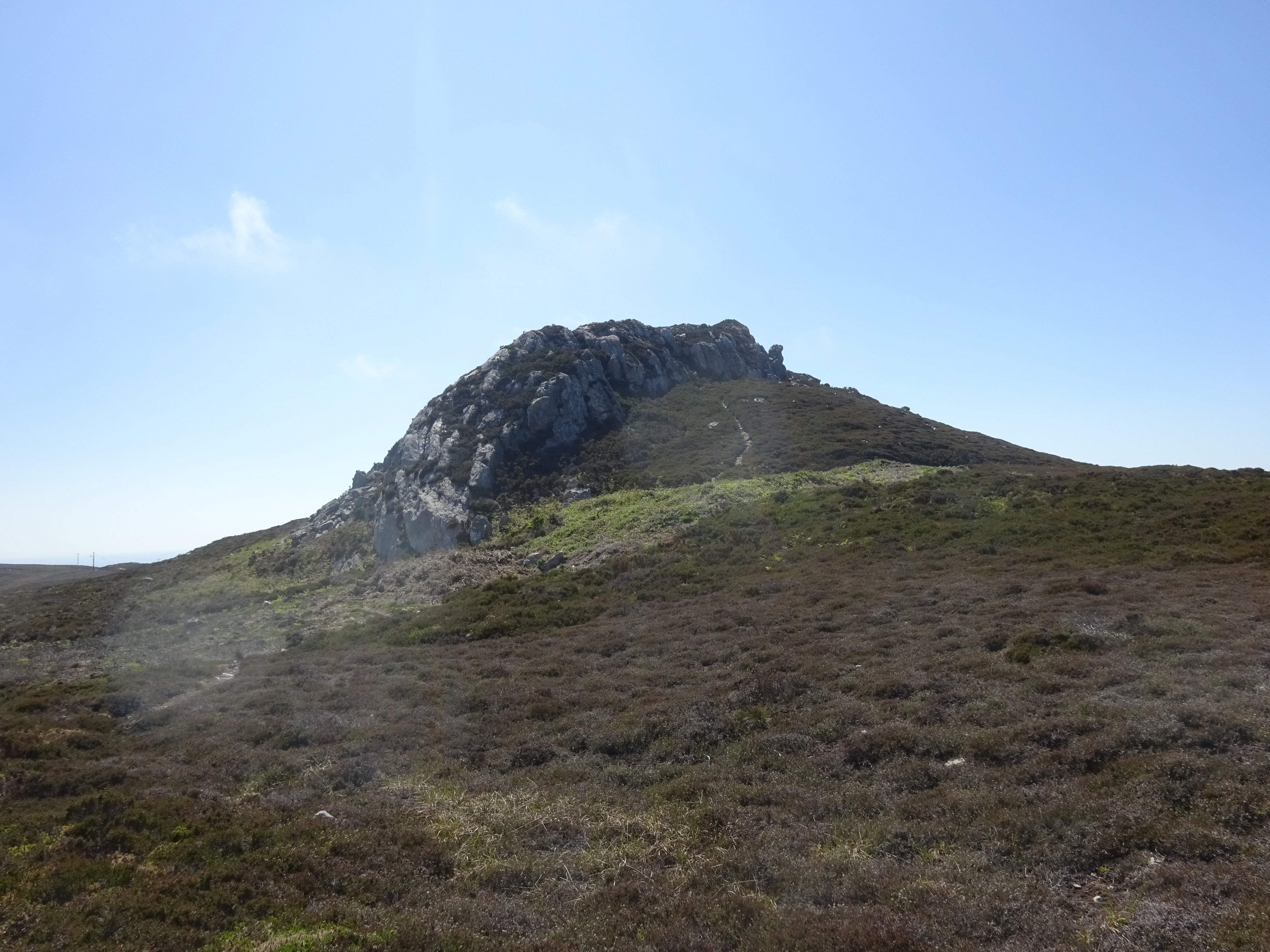
Tors on Holyhead Mountain - geograph.org.uk - 899214.jpg - GeographBot

View from the top of the quarry - geograph.org.uk - 896924.jpg - GeographBot

View from the western crags of Mynydd Twr - geograph.org.uk - 899320.jpg - GeographBot

View towards the summit of Mynydd Twr - geograph.org.uk - 898779.jpg - GeographBot

View westwards along the coast from the summit plateau of Mynydd Twr - geograph.org.uk - 899318.jpg - GeographBot

View westwards through a col with a radio station mast in the background - geograph.org.uk - 899661.jpg - GeographBot

A panorama of Holyhead Mountain from the Penrhosfeilw road - geograph.org.uk - 903206.jpg - GeographBot

Boulder field on the upper northern slope of Mynydd Twr - geograph.org.uk - 901320.jpg - GeographBot

Crags on Mynydd Twr - geograph.org.uk - 901564.jpg - GeographBot

Service track to the telecommunication station - geograph.org.uk - 901638.jpg - GeographBot

Telecommunications station on Holyhead Mountain - geograph.org.uk - 901630.jpg - GeographBot

The western face of Mynydd Twr from the rocky hill supporting the telecommunications station - geograph.org.uk - 901573.jpg - GeographBot

Breakwater Country Park - geograph.org.uk - 927551.jpg - GeographBot

Old Quarry Face - geograph.org.uk - 923923.jpg - GeographBot

Quarry Chimney across the Pond - geograph.org.uk - 923920.jpg - GeographBot

A Mist-Girdled Holyhead Mountain from Carmel Head - geograph.org.uk - 1404356.jpg - GeographBot

Former quarry, on the side of Holyhead Mountain - geograph.org.uk - 1412059.jpg - GeographBot

Path, to the top of Holyhead Mountain - geograph.org.uk - 1412068.jpg - GeographBot

Path to the top of Holyhead Mountain, from the east - geograph.org.uk - 1413509.jpg - GeographBot

Picnickers at the Breakwater Country Park - geograph.org.uk - 1416349.jpg - GeographBot

Pillbox and accommodation huts above Porth Namarch - geograph.org.uk - 1416478.jpg - GeographBot

Porth Namarch cove - geograph.org.uk - 1416362.jpg - GeographBot

Pwll Clai - a flooded clay pit at the Breakwater Country Park - geograph.org.uk - 1416342.jpg - GeographBot

Quarry road above Porth Namarch - geograph.org.uk - 1416359.jpg - GeographBot

Ruined building at the Breakwater Quarry - geograph.org.uk - 1416352.jpg - GeographBot

Summit of Holyhead Mountain - geograph.org.uk - 1412083.jpg - GeographBot

The coastline eastwards of Porth Namarch - geograph.org.uk - 1416470.jpg - GeographBot

The former Breakwater brickworks - geograph.org.uk - 1416334.jpg - GeographBot

The northernmost stone quarries at the Breakwater Country Park - geograph.org.uk - 1416326.jpg - GeographBot

View, from Holyhead Mountain - geograph.org.uk - 1413527.jpg - GeographBot
View eastwards towards Pwll Clai - geograph.org.uk - 1416365.jpg - GeographBot

View north, from Holyhead Mountain - geograph.org.uk - 1412073.jpg - GeographBot

View south-eastwards to the site of the former Breakwater Brickworks - geograph.org.uk - 1416356.jpg - GeographBot

Holyhead mountain from the Dublin ferry - geograph.org.uk - 1537495.jpg - GeographBot

Breakwater Lighthouse - geograph.org.uk - 1553575.jpg - GeographBot

Anglesey-flag-holyhead-mountain.jpg - Vexilo~commonswiki

Sunset on Holyhead mountain.jpg - ALIGOR1997

Holyhead mountain and South Stack bridge. from the island.jpeg - Jason.nlw

Holyhead Mountain, Holy Island (507264) (32938403591).jpg - OceanAtoll

William Howard Yorke - American Ship Grandee off Holyhead.jpg - Broichmore

Holyhead Mountain - Mynydd Twr - geograph.org.uk - 2013998.jpg - GeographBot

Holyhead Mountain from the HSC Jonathan Swift - geograph.org.uk - 2076519.jpg - GeographBot

Mynydd Twr a wal garreg ger y brif ffordd i Ynys Lawd, Ynys Mon, Cymru.jpg - Monsyn

Glannau Ynys Gybi SSSI. Between Ynys Lawd and Mynydd Twr, main radio masts buildings, Wales 03.jpg - Monsyn

Glannau Ynys Gybi SSSI. Between Ynys Lawd and Mynydd Twr, main radio masts buildings, Wales 02.jpg - Monsyn

Glannau Ynys Gybi SSSI. Between Ynys Lawd and Mynydd Twr, main radio masts buildings, Wales 01.jpg - Monsyn

A walk from Ynys Lawd (South Stack) to Mynydd Twr (Holyhead Mountain) 02.jpg - Monsyn

A walk from Ynys Lawd (South Stack) to Mynydd Twr (Holyhead Mountain) 01.jpg - Monsyn

A walk from Ynys Lawd (South Stack) to Mynydd Twr (Holyhead Mountain) 03.jpg - Monsyn

A walk from Ynys Lawd (South Stack) to Mynydd Twr (Holyhead Mountain) 04.jpg - Monsyn
A walk from Ynys Lawd (South Stack) to Mynydd Twr (Holyhead Mountain) 05.jpg - Monsyn

A walk from Ynys Lawd (South Stack) to Mynydd Twr (Holyhead Mountain) 06.jpg - Monsyn

A walk from Ynys Lawd (South Stack) to Mynydd Twr (Holyhead Mountain) 07.jpg - Monsyn

A walk from Ynys Lawd (South Stack) to Mynydd Twr (Holyhead Mountain) 08.jpg - Monsyn

A walk from Ynys Lawd (South Stack) to Mynydd Twr (Holyhead Mountain) 09.jpg - Monsyn

A walk from Ynys Lawd (South Stack) to Mynydd Twr (Holyhead Mountain) 10.jpg - Monsyn

A walk from Ynys Lawd (South Stack) to Mynydd Twr (Holyhead Mountain) 11.jpg - Monsyn

A walk from Ynys Lawd (South Stack) to Mynydd Twr (Holyhead Mountain) 14.jpg - Monsyn

A walk from Ynys Lawd (South Stack) to Mynydd Twr (Holyhead Mountain) 15.jpg - Monsyn

A walk from Ynys Lawd (South Stack) to Mynydd Twr (Holyhead Mountain) 13.jpg - Monsyn

A walk from Ynys Lawd (South Stack) to Mynydd Twr (Holyhead Mountain) 17.jpg - Monsyn

A walk from Ynys Lawd (South Stack) to Mynydd Twr (Holyhead Mountain) 16.jpg - Monsyn

On the summit of Mynydd Twr (Holyhead Mountain), Wales, where lies a wonderful Celtic fort 14.jpg - Monsyn

Holyhead Mountain - Mynydd Twr, not far from Holyheard itself in May 2021 01.jpg - Monsyn

Holyhead Mountain - Mynydd Twr, not far from Holyheard itself in May 2021 02.jpg - Monsyn

Quarry on Holyhead Mountain - Mynydd Twr, not far from Holyheard itself in May 2021 03.jpg - Monsyn

Quarry on Holyhead Mountain - Mynydd Twr, not far from Holyheard itself in May 2021 04.jpg - Monsyn

Quarry on Holyhead Mountain - Mynydd Twr, not far from Holyheard itself in May 2021 05.jpg - Monsyn

Masts on Holyhead Mountain - Mynydd Twr, not far from Holyheard itself in May 2021 06.jpg - Monsyn

Holyhead Mountain - Mynydd Twr, not far from Holyheard itself in May 2021 07.jpg - Monsyn

Holyhead Mountain - Mynydd Twr, not far from Holyheard itself in May 2021 08.jpg - Monsyn

Bottom of Holyhead Mountain - Mynydd Twr, not far from Holyheard itself in May 2021 09.jpg - Monsyn

Holyhead Mountain - Mynydd Twr, not far from Holyheard itself in May 2021 10.jpg - Monsyn

Holyhead Mountain - Mynydd Twr, not far from Holyheard itself in May 2021 11.jpg - Monsyn

View from Holyhead Mountain - geograph.org.uk - 2453579.jpg - GeographBot

Seen from Holy Mountain - geograph.org.uk - 2591376.jpg - GeographBot

Telecommunications equipment on Holyhead Mountain - geograph.org.uk - 2601039.jpg - GeographBot

Coastal path near Holyhead Mountain - geograph.org.uk - 2601041.jpg - GeographBot

View over Holyhead from Holyhead Mountain - geograph.org.uk - 2601048.jpg - GeographBot

Path up Holyhead Mountain - geograph.org.uk - 2601054.jpg - GeographBot

The trig point on Holyhead Mountain - geograph.org.uk - 2601068.jpg - GeographBot

The summit of Holyhead Mountain - geograph.org.uk - 2601074.jpg - GeographBot

Heathland management project on Mynydd Twr - geograph.org.uk - 2602151.jpg - GeographBot

Holyhead Mountain from the Anglesey Coastal Path - geograph.org.uk - 2606671.jpg - GeographBot

Low cloud over Holyhead Mountain - geograph.org.uk - 2615963.jpg - GeographBot

Holyhead breakwater.jpg - Pilipala56

Coastal View from Holyhead Mountain - geograph.org.uk - 3734438.jpg - GeographBot

Towards Holyhead Mountain - geograph.org.uk - 3745441.jpg - GeographBot

Holyhead Mountain - geograph.org.uk - 3745458.jpg - GeographBot

Holyhead Mountain - geograph.org.uk - 3745462.jpg - GeographBot

Holyhead Mountain - geograph.org.uk - 3745468.jpg - GeographBot

Holyhead Mountain - geograph.org.uk - 3745594.jpg - GeographBot

Holyhead Mountain - geograph.org.uk - 3745595.jpg - GeographBot

Holyhead Mountain - geograph.org.uk - 3745597.jpg - GeographBot

Towards Holyhead - geograph.org.uk - 3745601.jpg - GeographBot

Holyhead Mountain - geograph.org.uk - 3745605.jpg - GeographBot

Holyhead Mountain - geograph.org.uk - 3745608.jpg - GeographBot

Holyhead Mountain - geograph.org.uk - 3745609.jpg - GeographBot

Holyhead Mountain - geograph.org.uk - 3746287.jpg - GeographBot

Holyhead Mountain - geograph.org.uk - 3746346.jpg - GeographBot

Towards Holyhead Mountain - geograph.org.uk - 3746387.jpg - GeographBot

Telecommunications - geograph.org.uk - 3746389.jpg - GeographBot

Holyhead Mountain - geograph.org.uk - 3747368.jpg - GeographBot

Path heading for Holyhead Mountain - geograph.org.uk - 3918857.jpg - GeographBot

Trig Point, Mynydd Twr - geograph.org.uk - 4265789.jpg - GeographBot

Stone Rampart, Caer y Twr - geograph.org.uk - 4265795.jpg - GeographBot

On Holyhead Mountain - geograph.org.uk - 4535432.jpg - GeographBot

Looking east towards the port of Holyhead - geograph.org.uk - 4535441.jpg - GeographBot

Holyhead Mountain - geograph.org.uk - 4583340.jpg - GeographBot

A windy day on top of Holyhead Mountain - geograph.org.uk - 4583341.jpg - GeographBot

Holyhead Mountain - geograph.org.uk - 4583342.jpg - GeographBot

Holyhead Mountain crags - geograph.org.uk - 4583343.jpg - GeographBot

On Holyhead Mountain - geograph.org.uk - 4859566.jpg - GeographBot

Panorama from Holyhead Mountain - geograph.org.uk - 4860349.jpg - GeographBot

Panorama from Holyhead Mountain - geograph.org.uk - 4860353.jpg - GeographBot

Crags on Holyhead Mountain - geograph.org.uk - 5072821.jpg - GeographBot

Radio station on Holyhead Mountain - geograph.org.uk - 5072827.jpg - GeographBot

View north from the slopes of Holyhead Mountain - geograph.org.uk - 5072873.jpg - GeographBot

On the slopes of Holyhead Mountain - geograph.org.uk - 5072886.jpg - GeographBot

Radio Station near Holyhead Mountain - geograph.org.uk - 5484918.jpg - GeographBot

Paths towards Holyhead Mountain - geograph.org.uk - 5484931.jpg - GeographBot

Holyhead Mountain Radio Station - geograph.org.uk - 5484942.jpg - GeographBot

Circular stone structure near Holyhead Mountain - geograph.org.uk - 5486638.jpg - GeographBot

The Anglesey Coastal Path approaching Holyhead Mountain - geograph.org.uk - 5486672.jpg - GeographBot

The Anglesey Coastal Path below Holyhead Mountain - geograph.org.uk - 5486684.jpg - GeographBot

Holyhead Mountain - geograph.org.uk - 5486700.jpg - GeographBot

Holyhead Mountain - geograph.org.uk - 5524887.jpg - GeographBot

Paths and tarn to west of Holyhead Mountain, Holy Island, Anglesey - geograph.org.uk - 5642374.jpg - GeographBot

Radio station below Holyhead Mountain, Holy Island, Anglesey - geograph.org.uk - 5642393.jpg - GeographBot

Path towards the summit of Holyhead Mountain, Holy Island, Anglesey - geograph.org.uk - 5642396.jpg - GeographBot

Holyhead Mountain and South Stack Road - geograph.org.uk - 5870688.jpg - GeographBot

Triangulation pillar marking the top of Holyhead mountain. - geograph.org.uk - 6033486.jpg - GeographBot

Forking of paths on Holyhead Mountain - geograph.org.uk - 6292681.jpg - GeographBot

Climber on Mynydd Twr.jpg - Skyrail