Wikimedi'Òc
Modes d'emploi

Cet album fait partie des albums
Cet album photos contient les sous-albums suivants :


Elliott Knob Augusta County Virginia USA.jpg - Qbek

White Rocks Little Sluice Mountain GWNF.jpg - Qbek

Spit rail fence Sherando Lake.jpg - Edbrown05~commonswiki

Paintedtrillium.jpg - BetacommandBot

View from Buzzard Rock.jpg - Qbek

Shenandoah Mountain - High Knob.jpg - Bitmapped

Hophornbeam (1017000173).jpg - File Upload Bot (Magnus Manske)

Wash day at Camp Roosevelt, George Washington National Forest, Virginia (3226977352).jpg - File Upload Bot (Magnus Manske)

Piling up poles, Camp Roosevelt, George Washington National Forest, Virginia (3226943004).jpg - File Upload Bot (Magnus Manske)

Meal time at CCC Camp Roosevelt, George Washington National Forest, Virginia (3226029283).jpg - File Upload Bot (Magnus Manske)

Mount Pleasant, Virginia.jpg - Edsrice

Elliott Knob SE.JPG - MONGO

Elliott Knob radio towers.JPG - MONGO

Signal Knob - panoramio.jpg - Panoramio upload bot

Roaring Run Furnace 1.jpg - Michael Veax

Roaring Run Furnace 3.jpg - Vort

Roaring Run Furnace 2.jpg - R8cocin8

Barbours Creek Wilderness (17874535321).jpg - Fredlyfish4

Campbell Gorge Three Ridges Wilderness.jpg - Fredlyfish4

2016-05-19 16 41 14 View south across Devrick Hollow on the west side of Shenandoah Mountain from the Highland Turnpike (U.S. Route 250) in Highland County, Virginia.jpg - Famartin

2016-05-19 16 41 16 View southwest across Devrick Hollow on the west side of Shenandoah Mountain from the Highland Turnpike (U.S. Route 250) in Highland County, Virginia.jpg - Famartin

2016-05-19 16 41 18 View west across Devrick Hollow on the west side of Shenandoah Mountain from the Highland Turnpike (U.S. Route 250) in Highland County, Virginia.jpg - Famartin

2016-05-19 16 41 33 Panorama south and west across Devrick Hollow on the west side of Shenandoah Mountain from the Highland Turnpike (U.S. Route 250) in Highland County, Virginia.jpg - Famartin

2016-05-27 12 47 26 Catawba Rhododendron flowering along Virginia State Route 56 (Crabtree Falls Highway) near Montebello in the portion of George Washington and Jefferson National Forest in Nelson County, Virginia.jpg - Famartin
2016-05-27 12 47 50 Catawba Rhododendron flowering along Virginia State Route 56 (Crabtree Falls Highway) near Montebello in the portion of George Washington and Jefferson National Forest in Nelson County, Virginia.jpg - Famartin

2016-06-06 08 57 22 Pine along U.S. Route 33 (Blue Gray Trail) near the High Knob Trailhead in southeastern Pendleton County, West Virginia.jpg - Famartin

Sinking Creek, Virginia - panoramio.jpg - Panoramio upload bot

Meadow Creek - panoramio.jpg - Panoramio upload bot

Pulloff on Route 42 - panoramio.jpg - Panoramio upload bot

New Castle Overlook off Route 42 - panoramio.jpg - Panoramio upload bot

Jefferson National Forest - panoramio.jpg - Panoramio upload bot

Jefferson National Forest - panoramio (1).jpg - Panoramio upload bot

Eastern, VA, USA - panoramio (10).jpg - Panoramio upload bot

Eastern, VA, USA - panoramio (11).jpg - Panoramio upload bot

Eastern, VA, USA - panoramio (12).jpg - Panoramio upload bot

Eastern, VA, USA - panoramio (13).jpg - Panoramio upload bot

Eastern, VA, USA - panoramio (14).jpg - Panoramio upload bot

Hiking in the Jefferson National Forest - panoramio.jpg - Panoramio upload bot

Right angles in Nature - panoramio.jpg - Panoramio upload bot
White Rocks Self Port.jpg - Antepenultimate

2016-07-08 13 35 25 Road Closed sign on a gate blocking a dirt road adjacent to U.S. Route 48 and West Virginia Route 55 (Wardensville Pike) on Great North Mountain in eastern Hardy County, West Virginia.jpg - Famartin

2016-07-08 16 51 06 View east along West Virginia State Route 59 (Lower Cove Run Road) entering the George Washington National Forest just east of Lost City in Hardy County, West Virginia.jpg - Famartin

2016-07-08 16 55 35 View east along West Virginia State Route 59 (Lower Cove Run Road) at Hardy County Route 59-1 (Middle Cove Run Road) within the George Washington National Forest in Hardy County, West Virginia.jpg - Famartin

2016-07-08 16 56 05 View west along West Virginia State Route 59 (Lower Cove Run Road) at Hardy County Route 59-1 (Middle Cove Run Road) within the George Washington National Forest in Hardy County, West Virginia.jpg - Famartin

2016-07-08 17 02 16 View east along West Virginia State Route 59 (Lower Cove Run Road) at the end of pavement within the George Washington National Forest in Hardy County, West Virginia.jpg - Famartin

2016-07-08 17 03 14 View west along West Virginia State Route 59 (Lower Cove Run Road) at the beginning of pavement within the George Washington National Forest in Hardy County, West Virginia.jpg - Famartin

2016-07-08 17 06 56 View east along West Virginia State Route 59 (Lower Cove Run Road) at Hardy County Route 59-2 (Mill Gap-Orkney Spring Road) within the George Washington National Forest in Hardy County, West Virginia.jpg - Famartin

2016-07-08 17 30 53 View west where Virginia State Secondary Route 691 (Judge Rye Road) becomes West Virginia State Route 59 (Lower Cove Run Road) as it crosses into Hardy County, West Virginia from Frederick County, Virginia.jpg - Famartin

2016-07-08 17 31 18 View east where West Virginia State Route 59 (Lower Cove Run Road) becomes Virginia State Secondary Route 691 (Judge Rye Road) as it crosses into Frederick County, Virginia from Hardy County, West Virginia.jpg - Famartin

2016-07-08 17 36 22 View west along West Virginia State Route 59 (Lower Cove Run Road) near Hardy County Route 59-2 (Mill Gap-Orkney Spring Road) within the George Washington National Forest in Hardy County, West Virginia.jpg - Famartin

2016-07-08 17 40 10 View west along West Virginia State Route 59 (Lower Cove Run Road) just east of Stoney Mountain Road within the George Washington National Forest in Hardy County, West Virginia.jpg - Famartin

2016-07-08 17 45 56 View west along West Virginia State Route 59 (Lower Cove Run Road) west of Hardy County Route 59-2 (Middle Cove Run Road) within the George Washington National Forest in Hardy County, West Virginia.jpg - Famartin
Pine Swamp Branch.jpg - WilderAddict

Wildflower in Mountain Lake Wilderness Cluster (Virginia) near VA 635.jpg - WilderAddict

Polypor in Mountain Lake Wilderness Cluster (Virginia), near VA 635.jpg - WilderAddict
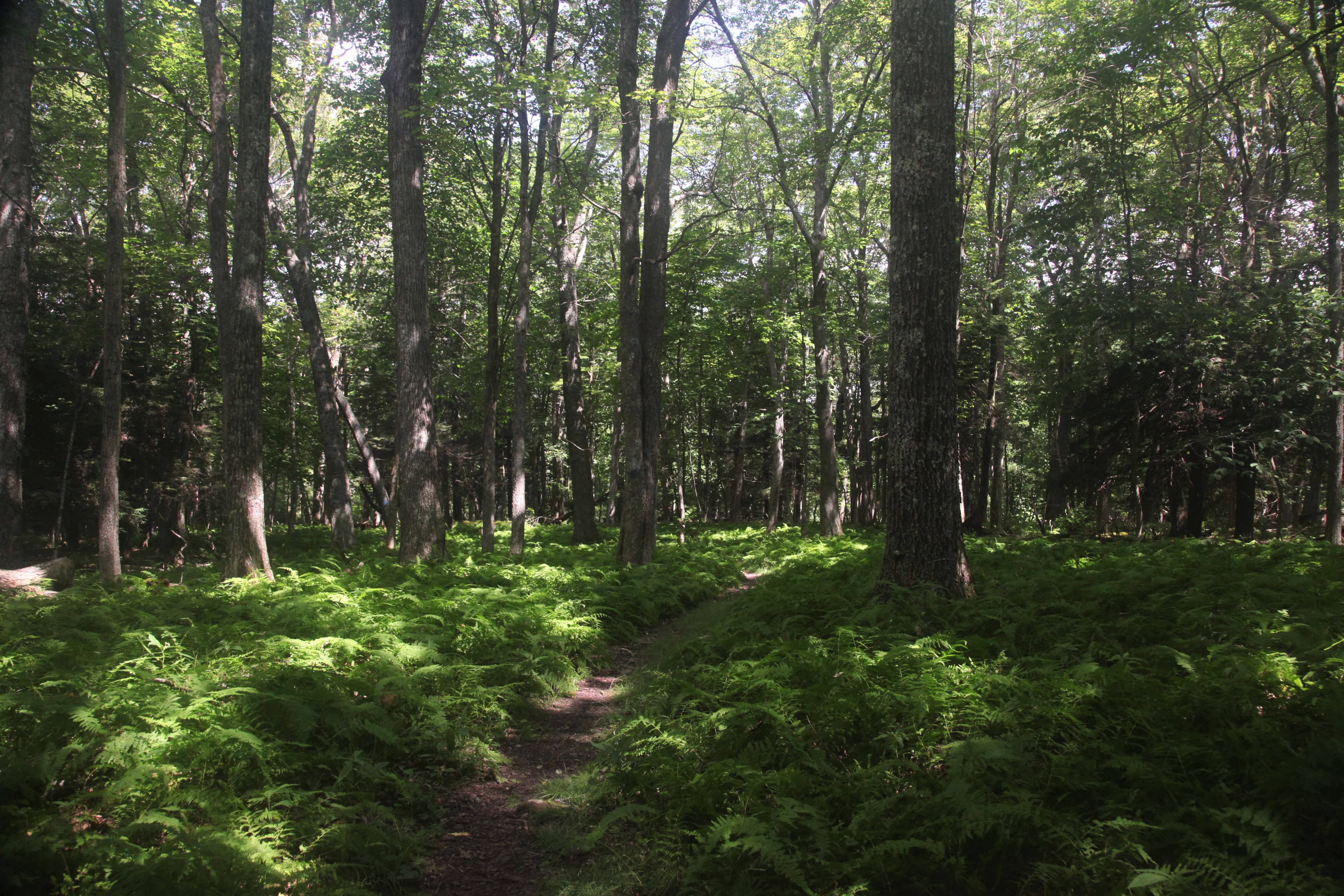
Path in forest in Mountain Lake Wilderness Cluster (Virginia) , near Va 635.jpg - WilderAddict

Mountain Lake Road (Va 635) in Mountain Lake Wilderness Cluster (VA).jpg - WilderAddict

Roaring Run Furnace.jpg - Nyttend

Little-Stony-Creek-Shenandoah-Virginia-12-Nov-2017.jpg - Taylordw

Little-Stony-Creek-West-End Reservoir-Dam-Woodstock-Virginia-10-Nov-2017.jpg - Taylordw

Terrapin Mountain viewed from the Blue Ridge Parkway.jpg - WilderAddict

Contrasting Ridges in Virginia - Labeled.jpg - Jalbertbowdenii

Contrasting Ridges in Virginia.jpg - Jalbertbowdenii

Callie Furnace overview.jpg - Nyttend

Hidden Valley Rockshelter.jpg - Nyttend

View across North Creek (conservation area) looking northeast from Middle Creek Rd, Fall 2019.jpg - WilderAddict

VA Wytheville 188819 1982 100000 geo.jpg - WilderAddict

KY Pikeville 710086 1977 100000 geo-1.png - WilderAddict

VA Bristol 188766 1981 100000 geo-1.png - WilderAddict

The fir-spruce mountain meadows on Whitetop Mountain.jpg - WilderAddict

Scales from the Virginia Highlands Trail.jpg - WilderAddict

Buzzard Rock.jpg - WilderAddict

Mount Rogers view.jpg - WilderAddict
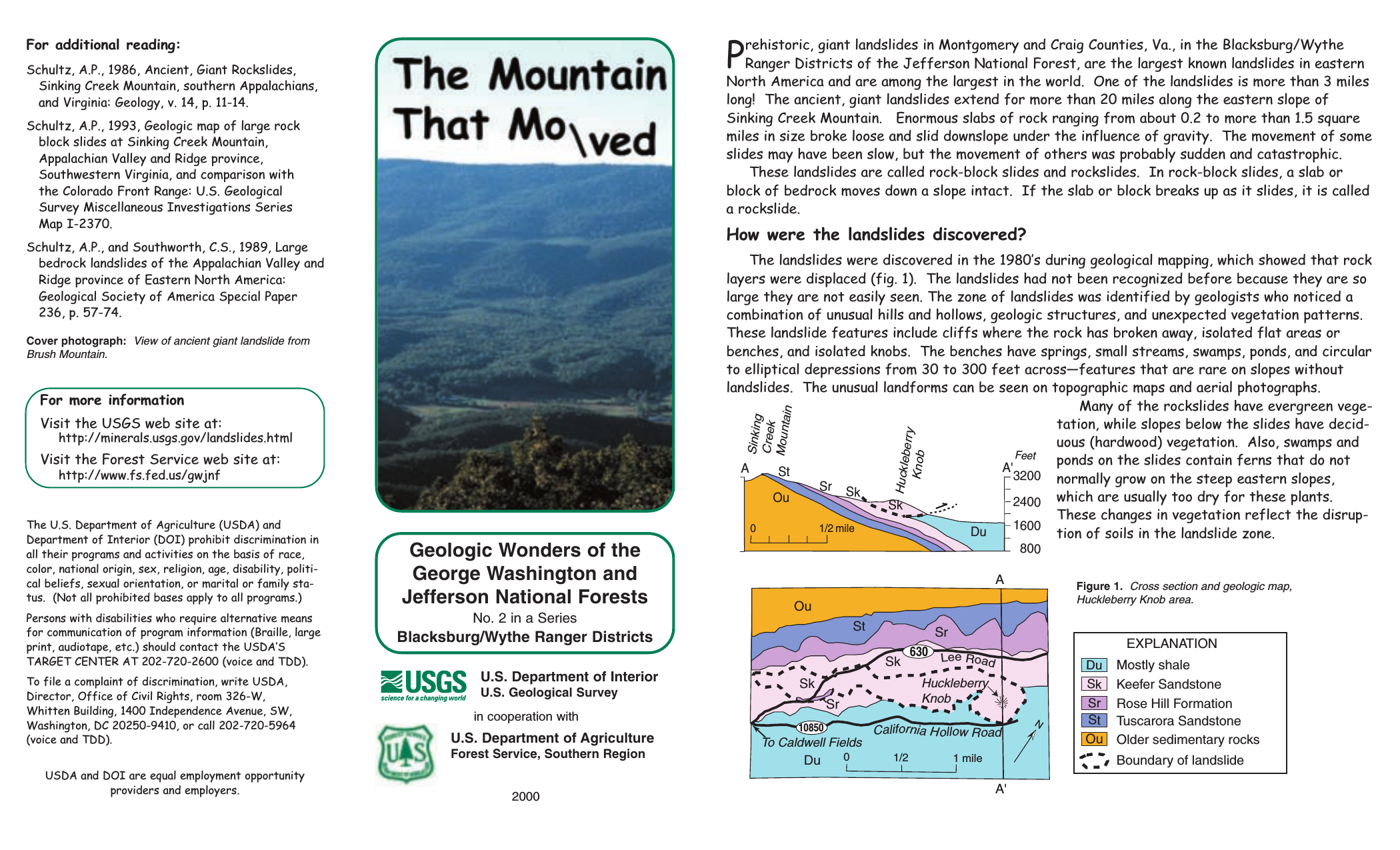
SinkingCreekLandslide-1.png - WilderAddict

SinkingCreekLandslide-2.png - WilderAddict
LandslideUSFS.pdf - WilderAddict
Volcanic Fire and Glacial Ice Mount Rogers National Recreation Area.pdf - WilderAddict

2019-08-09 14 21 14 View east along U.S. Route 33 (Rawley Pike) within the George Washington National Forest near Rawley Springs, Rockingham County, Virginia.jpg - Famartin

2019-10-26 12 51 32 View south across Devrick Hollow on the west side of Shenandoah Mountain from the Highland Turnpike (U.S. Route 250) in Highland County, Virginia.jpg - Famartin

2019-10-26 12 51 49 View west across Devrick Hollow on the west side of Shenandoah Mountain from the Highland Turnpike (U.S. Route 250) in Highland County, Virginia.jpg - Famartin

2019-10-26 12 51 47 View southwest across Devrick Hollow on the west side of Shenandoah Mountain from the Highland Turnpike (U.S. Route 250) in Highland County, Virginia.jpg - Famartin

2019-10-26 12 52 19 View east across Salthouse Hollow on the west side of Shenandoah Mountain from the Highland Turnpike (U.S. Route 250) in Highland County, Virginia.jpg - Famartin

2019-10-26 12 52 22 View northeast across Salthouse Hollow on the west side of Shenandoah Mountain from the Highland Turnpike (U.S. Route 250) in Highland County, Virginia.jpg - Famartin

Crawfish Valley, Wythe County, Southwest Virginia,.jpg - WilderAddict

Land Use Rehabilitation - Virginia - DPLA - 8bac7eb2ac8c83c7683d9bd90105e649.jpg - DPLA bot

Signs - Virginia - DPLA - beb9141e8d60e3ee85498bc21f4b9a73.jpg - DPLA bot

Logging- Felling - Virginia - DPLA - 96aeb36dd6d60512997be09748a59232.jpg - DPLA bot

Lake Scenes - Virginia - DPLA - d24455fc21b41ea38bef67cbda2a9ee9.jpg - DPLA bot

Timber Management - Partial Cutting - Virginia - DPLA - 3724ec24caeee1a7d6463a1621f92567.jpg - DPLA bot

Timber Management- Types - Virginia - DPLA - e1657a5342a8fdd49dca362f90ea0209.jpg - DPLA bot

Rodents- Squirrels, Chipmunks - All States - DPLA - 88dde278d370b03f231051ce22be754e.jpg - DPLA bot

Road Construction - Virginia - DPLA - d409d6314c1b8c5d50ac73b0bdd6ffe9.jpg - DPLA bot

George Washington National Forest (22279721799).jpg - English Roger

George Washington National Forest, Virginia 2 - by J.D. Savanyu.jpg - Jarrod stanley

George Washington National Forest, Virginia 1 - by J.D. Savanyu.jpg - Jarrod stanley

George Washington National Forest, Virginia 3 - by J.D. Savanyu.jpg - Jarrod stanley

Wkm-boldfrontiers-0007-massanutten-storybook-trail.jpg - Boldfrontiers

Trout Pond, West Virginia.jpg - Dclemens1971