Wikimedi'Òc
Modes d'emploi

Cet album fait partie des albums
Cet album photos contient les sous-albums suivants :


The approximate extent of the Shemshak Group outcrops is marked in red (some locations are larger than reality).png - Iranshahi.Amir Ali

ZagrosFTB.png - Mikenorton

SouthCaspian.jpg - Interfase
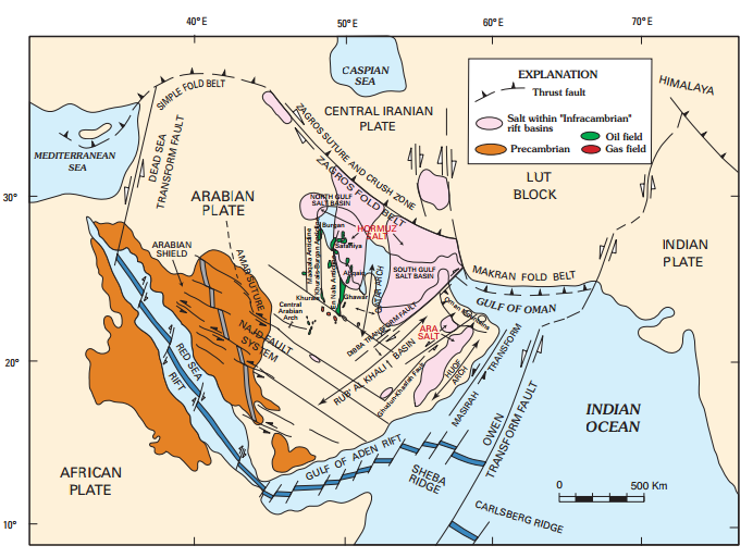
Arabian Plate showing general tectonic and structural features, Infracambrian rift salt basins, and oil and gas fields of Central Arabia and North Gulf area (usgs.gov).png - Sshafe2

Arabian Plate showing general tectonic and structural features, Infracambrian rift salt basins, and oil and gas fields of Central Arabia and North Gulf area.svg - Sette-quattro

GarmsarMap.JPG - BotMultichill

856 Damghan setting.png - Mikenorton

Iran geology (Cro).PNG - Orijentolog

Geological zones of Iran (Cro).PNG - Orijentolog

Iran mineral deposits (Cro).jpg - Orijentolog

Qeshm geology.png - Mikenorton

FaultsIran.png - Orijentolog

The Quarterly journal of the Geological Society of London (12711896214).jpg - Fæ
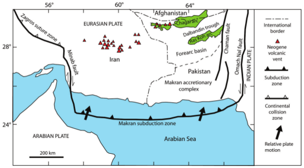
Makran subduction zone.png - WikiWikiWayne

Tehran Faults.svg - Yamaha5

Iran Faults map.svg - Yamaha5

Structural geologic map of Iran.jpg - Tisquesusa

Carte geologique elbourz.svg - Boldair

نقشه میدان های گازی و نفتی استان بوشهر به همراه اطلاعات توپوگرافی و ژرفاسنجی.png - Rohalamin

Carte geologique elbourz-es.svg - Rowanwindwhistler

نقشه حمل و نقل استان بوشهر.png - Rohalamin

Map of Tehran faults in a radius of 150 km.svg - Parsa 2au