Wikimedi'Òc
Modes d'emploi

Cet album fait partie des albums
Cet album photos contient les sous-albums suivants :


Carte géologique du Yunnan oriental.jpg - Lucile Poulain (BSU)

Earthquakes in China since 186 BC.png - Jo Weber

General map of central and southern Tibet.png - Mausbu1

Yangtse craton location.jpg - Ciaurlec

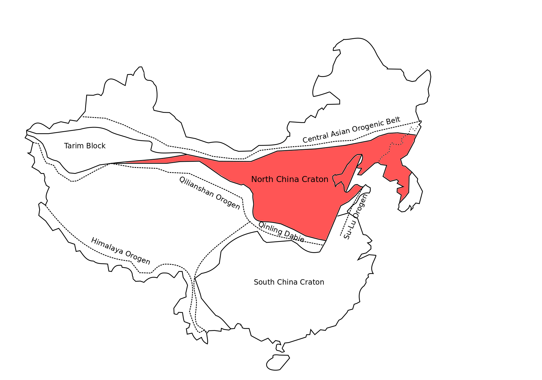
North China Craton.gif - DBoyd13

Xiong'er Volcanic Belt Location.jpg - DBoyd13
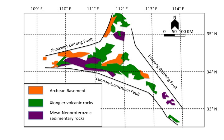
Xiong'er Volcanic Belt.jpg - DBoyd13

Xiong'er Simplified Geologic Map.jpg - DBoyd13
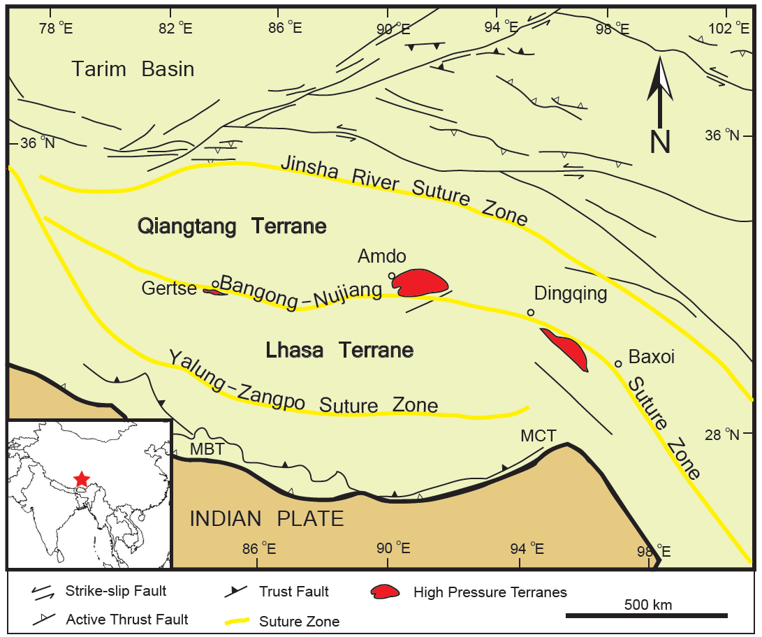
Bangong-Nujiang Suture Zone.png - Chasebill

HKGeoDB.svg - Kayau

Geology of Everest region, 1921.jpg - OgreBot

Zhanghenglong yangchengensis locality.png - Ras67
Map of tectonics in Asia.jpg - Niklitov

4The structural geology map indicating the rock distribution and structural characteristics of the Huangling complex.png - Lydia yip

Topographic map of Huangling complex.png - Lydia yip

Western Extrusion Model.png - Lydia yip

Eastern Extrusion Model.png - Lydia yip

A Map of South China Craton.png - Lydia yip

Location of Huangling Complex.png - Lydia yip

Huangling Stratigraphy.png - Ciaurlec

Xingxiulong-1.jpg - Lythronaxargestes

Painted tectonic map.jpg - Arous18
China map with craton and tectonic elements .png - Ciaurlec

China, North Korea, and South Korea map with craton and tectonic elements final 3.png - Ciaurlec

North China phanerozoic tectonic elements.png - Celiayangyy

Location of Qinlin on China Map.png - YCYBenjamin

Location of qinling.png - YCYBenjamin

Lianhuashan fault zone 1.jpg - HarrietHKUGeology

Lianhuashan fault zone.png - HarrietHKUGeology

Fault Zones 2.png - HarrietHKUGeology

China, North Korea, and South Korea geology map.png - Dushan Jugum

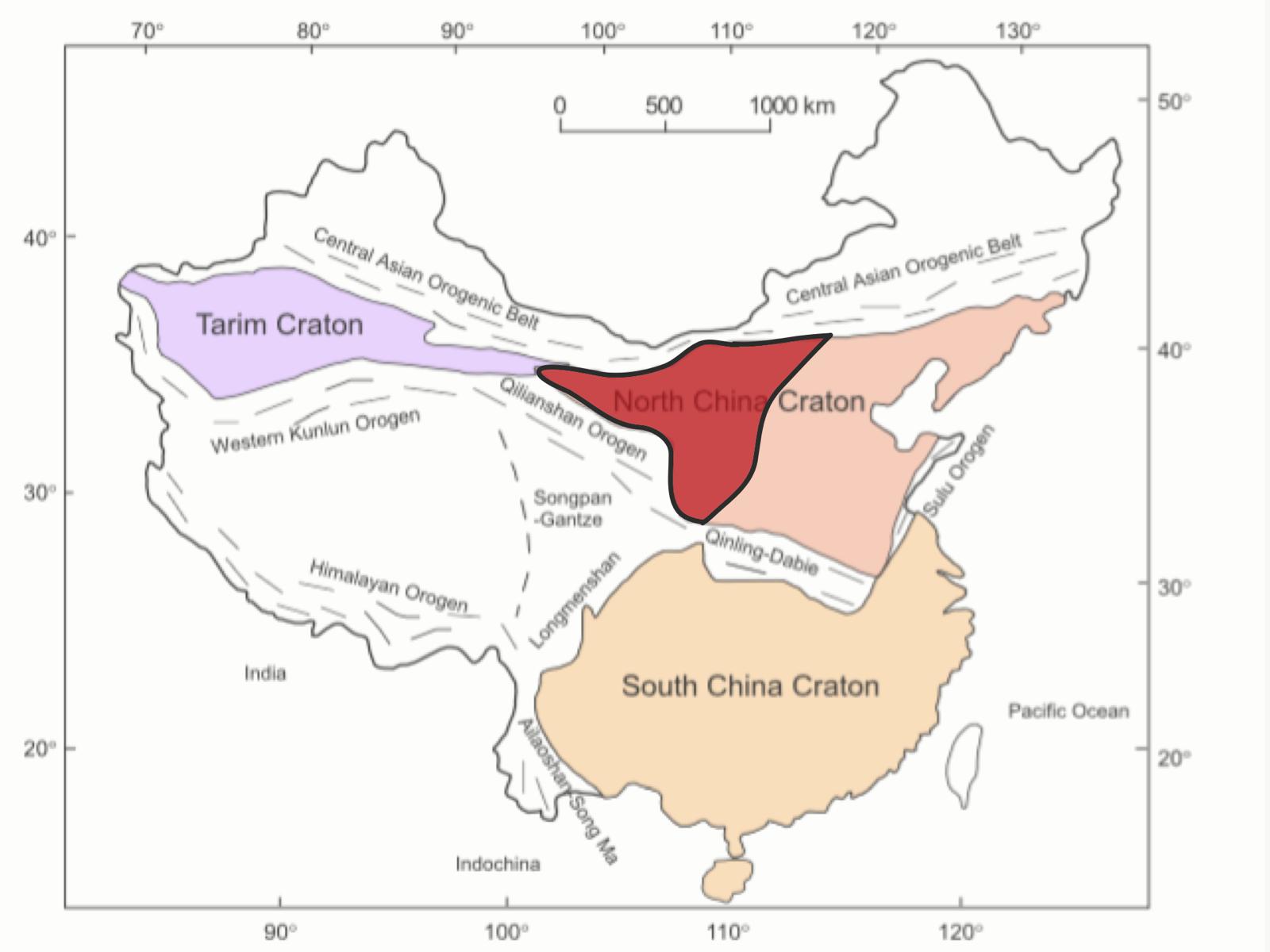
Location of North China Craton.png - HelenHYW
The location of Western Block of North China Craton.jpg - HelenHYW

Geological map of the Western Block of the North China Craton.png - HelenHYW

TibetElevationMap.jpg - Coffeeandcrumbs

Fig1-Digital-elevation-model-DEM-image-showing-a-simplified-structural-map-of-the-Yinchuan-basin-and-adjacent-area.gif - Sohmen
Map of Northern China.png - Christycheungkayan

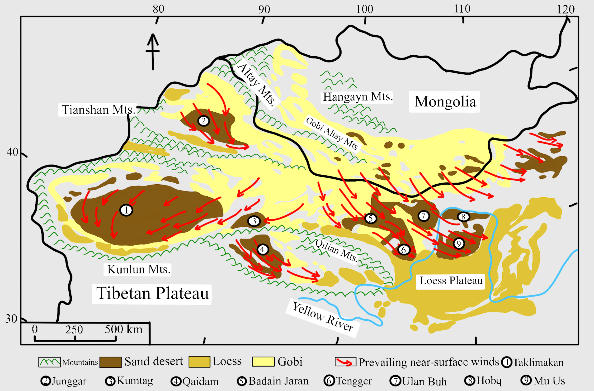
GeoMap of Loess Plateau.png - Christycheungkayan

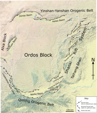
Ordos Block.png - Mikenorton

Loess Plateau loess thickness.png - Christycheungkayan

1924 General geological map of China - Peking-Tsinan Sheet, by C. C. Ch'iao and Xichou Tan, from the Digital Commonwealth - commonwealth 3f4638258.jpg - Daderot

Tianjingshan fault.png - Mikenorton

Asset 2fault map.png - Calvinw72
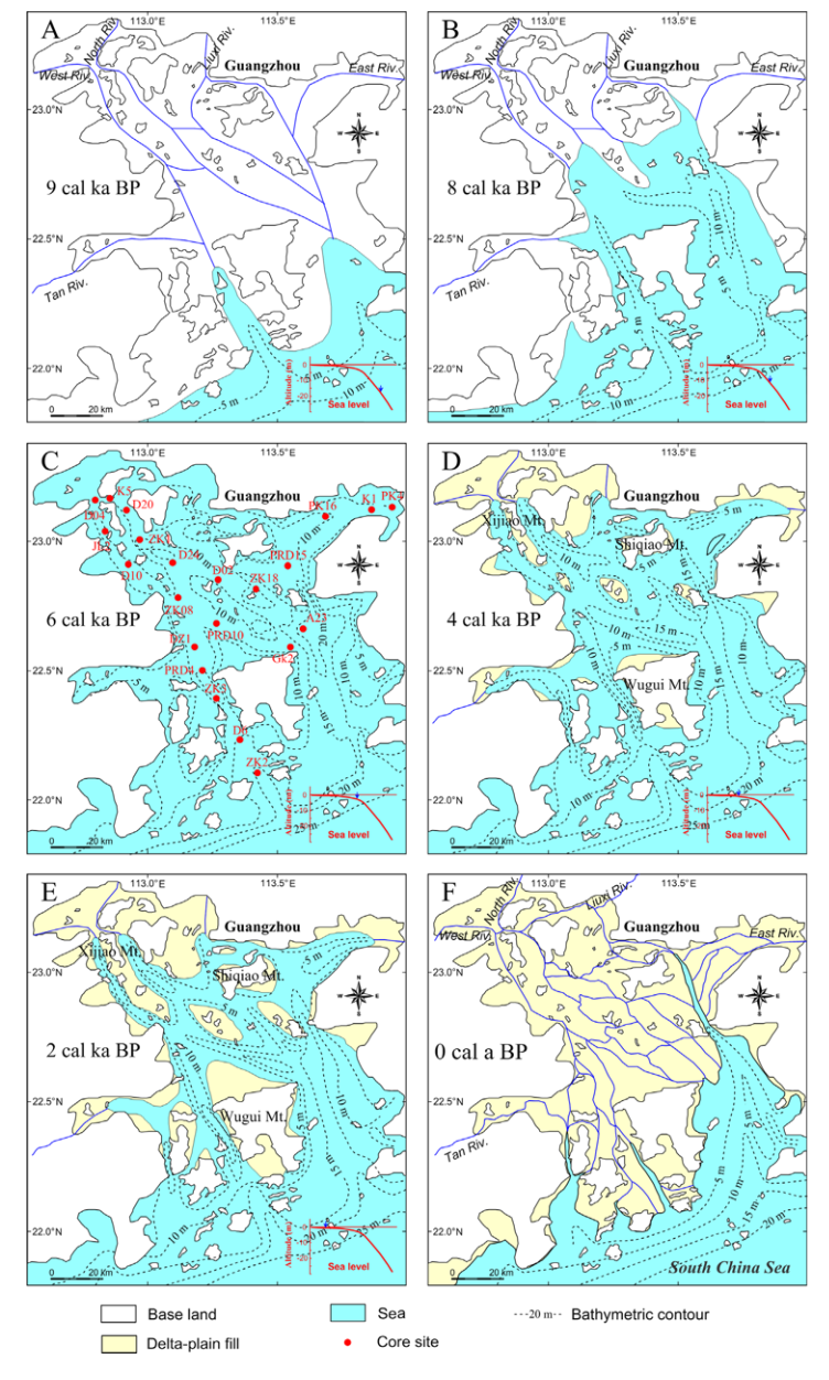
Sea level change PRD.png - Calvinw72

螢幕截圖 2023-11-14 上午3.21.46.png - Calvinw72

螢幕截圖 2023-11-14 上午5.27.10.png - Calvinw72

Asset 1 latest.png - Calvinw72

Geologische Karte des Singhbhum-Kratons.png - Chillibilli

Millennium-Eruption-map.png - Ant.costa74

Xianshuihe fault system.png - Mikenorton

Ziliujing Formation.png - Olmagon

Liaoning rock outcrop map.png - A Cynical Idealist

North China Craton in China, North Korea, and South Korea map with craton and tectonic elements.png - Ciaurlec

Qingtujing Group (locality and stratigraphy).png - SlvrHwk