Wikimedi'Òc
Modes d'emploi

Cet album fait partie des albums
Cet album photos contient les sous-albums suivants :
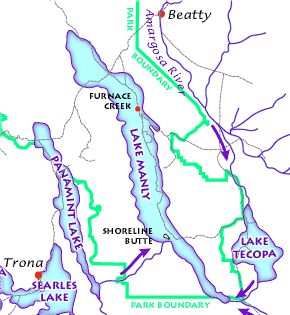


Lake Manly system.png - Ras67

Sfbay srt 1906108.jpg - Holly Cheng

Geologic map California.jpg - Urban~commonswiki

Carte geologique Californie.JPG - Urban~commonswiki

Cinder Cone Lassen geologic map.png - Mav

Map of Mount Shasta debris avalanche.png - Ras67

California Gold Rush relief map.png - Sergio~commonswiki
CA ShakeOut Map.pdf - SCEC

Pleistocene Lakes and Rivers of Mojave.png - Emerson7

Geothermal areas in Lassen area.gif - Gemini1980
Wpdms shdrlfi020l owens river.jpg - MGA73bot2
Wpdms shdrlfi020l santa susana mountains.jpg - MGA73bot2

California Geomorphic Provinces.svg - AnonMoos

Santa Rosa Geological Structure.png - Mikenorton

DistributionMap.png - File Upload Bot (Magnus Manske)
Of99-14 4a a.pdf - Rhalden~commonswiki
Explanation Regional Geologic Map of San Andreas and Related Faults in Carrizo Plain, Temblor, Caliente and La Panza Ranges and Vicinity, California.pdf - Rhalden~commonswiki
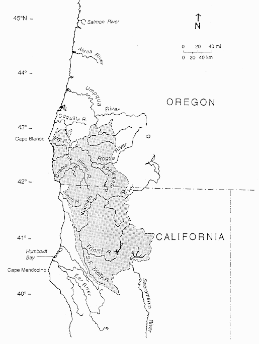
Klamath Mountains map.gif - Jsayre64

Columbia River Flood-Basalt Province.jpg - J. Johnson

Humboldt County Geology Map USGS.jpg - Ellin Beltz

Cascade Range geology detail.png - Hike395

Great Valley Sequence map.gif - Mikesclark

Geologic map of Vaca Mountains.jpg - Mikesclark

Geological Map of the White Ledge Peak Triangle (Carpinteria Zoom).jpg - Doopokko

Geological Map of the White Ledge Peak Triangle.jpg - Doopokko

A bottom gravity survey of the shallow water regions of southern Monterey Bay and its geological interpretation. (1973) (20406336615).jpg - SteinsplitterBot

Alabama G-E-M resources area (GRA no. CA-09) - technical report (WSAs CA 010-057, 010-058, and 010-064) - final report (1983) (17948758191).jpg - Fæ

Bibliography of marine geology and oceanography, California coast (1955) (20181515159).jpg - Fæ

ShakeAlert - example.jpg - DarTar

Report of the State Mineralogist (1892) (14759686646).jpg - Faebot

USGS isoseismal map - 1857 Fort Tejon earthquake.gif - Dawnseeker2000

MountTehama-map.jpg - YanikB

La basin location.png - Gciast1

Features of basin.png - Gciast1
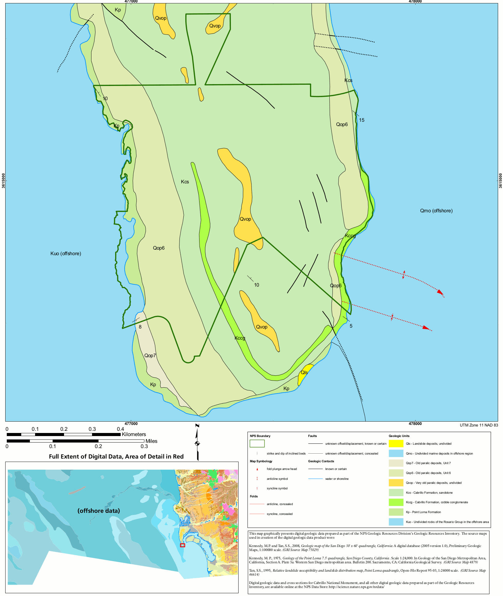
NPS cabrillo-geologic-map.gif - RKBot

NPS devils-postpile-geologic-map.jpg - RKBot

NPS manzanar-geologic-map.gif - RKBot

NorthernSanJoaquinValleyOilGasFields.png - Pi3.124

MarysvilleButtesGasFieldGeologicMap.png - Pi3.124

The Geysers geologic map.png - Pi3.124

Geological map of northwest USA showing Basin and Range faults and basalts and rhyolites up to17 Ma.png - SphericalSong
Generalized Geologic Map of Butte County, California.pdf - RyanMikulovsky

Geologic map depicting the Smartville Complex and other accreted terranes in California.jpg - Pi3.124

Grass Valley Geologic Map.jpg - Pi3.124

Cascade Range geology detail.gif - Hike395
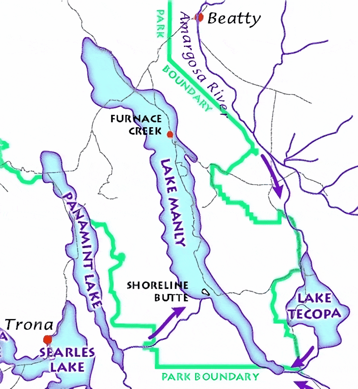
Lake Manly system.gif - Hike395

Preliminary Mineralogical and Geological Map of the State of California, 1891.jpg - AccidentallyDigital