Wikimedi'Òc
Modes d'emploi

Cet album fait partie des albums
Cet album photos contient les sous-albums suivants :


-mypubliclandsroadtrip 2016- Step Back in Time, General Land Office (28320888925).jpg - OptimusPrimeBot

-mypubliclandsroadtrip 2016- Step Back in Time, General Land Office (28242321931).jpg - OptimusPrimeBot

-mypubliclandsroadtrip 2016- Step Back in Time, General Land Office (28242303521).jpg - OptimusPrimeBot

-mypubliclandsroadtrip 2016- Step Back in Time, General Land Office (28320853715).jpg - OptimusPrimeBot

Meridians-baselines.png - Ziv

US GENERAL LAND OFFICE Geodetic control point Douglas WY.JPG - Wusel007

1897 Land Office Map of the Island of Molokai, Hawaii - Geographicus - MolokaiHawaii-lo-1897.jpg - BotMultichillT

US General Land Office Deed 1845.jpg - File Upload Bot (Magnus Manske)

Credit Island Iowa 1838.jpg - File Upload Bot (Magnus Manske)
General Land Office logo.jpg - Roseohioresident

Molokai Hawaiian Islands 1897.jpg - National Public Domain Archive

General Land Office Survey Marker Sahuarita Arizona 2014.jpg - FastilyClone
MW Patent 1097-068.PDF - Awmanthisgirl

General Land Office Survey Marker - panoramio.jpg - Panoramio upload bot

Signs president's name. Washington, D.C., Sept. 8. Affixing the signature "Franklin D. Roosevelt" to land grants and patents, Jeanne (...), 20, is getting a great thrill out of her new LCCN2016872306.jpg - Fæ

Definite location from of the Northern Pacific Railroad from the initial point on Lake Superior to the east end of the completed track - NARA - 102256602.jpg - US National Archives bot

Definite location of the Denver Pacific Railroad - NARA - 102256358.jpg - US National Archives bot

Definite location of the Northern Pacific Railroad fro the 25th to the 50th mile post, easterly from Tacoma, Washington - NARA - 102256598.jpg - US National Archives bot

Definite location of the Northern Pacific Railroad from Ellensburg to Eagle Gorge - NARA - 102256600.jpg - US National Archives bot

Definite location of the Northern Pacific Railroad from the Missouri River to the Dakota TeRailroaditory - NARA - 102256578.jpg - US National Archives bot

Definite location of the Northern Pacific Railroad from Yakima City, 50 miles northwesterly in Washington Territory - NARA - 102256596.jpg - US National Archives bot

Definite location of the Northern Pacific Railroad through the Flathead Reservation - NARA - 102256594.jpg - US National Archives bot

Definite locaton of the Northern Pacific Railroad through the Crow Reservation - NARA - 102256604.jpg - US National Archives bot

Definite locaton of the Northern Pacific Railroad through the Crow Reservation - NARA - 102256606.jpg - US National Archives bot
A history of the United States General Land Office in Oregon (IA historyofuniteds00vaug).pdf - Fæ
Report of the Commissioner of the General Land Office to the Secretary of the Interior, fiscal year ended June 30, 1941 (IA reportofcommissi00unse 37).pdf - Fæ
Land service bulletin - Volume 2 (IA landservicebulle02unit).pdf - Fæ

Highland-pines-prescott-az.png - Wandhlder9

BIG BEN 1 LODE Highland Pines.jpg - Wandhlder9

BIG BEN 2 LODE Highland Pines.jpg - Wandhlder9

Binger-Hermann Genaral-Land-Office.jpg - Wandhlder9
Binger-Hermann-3125-mineral-survey-patented.jpg - Wandhlder9

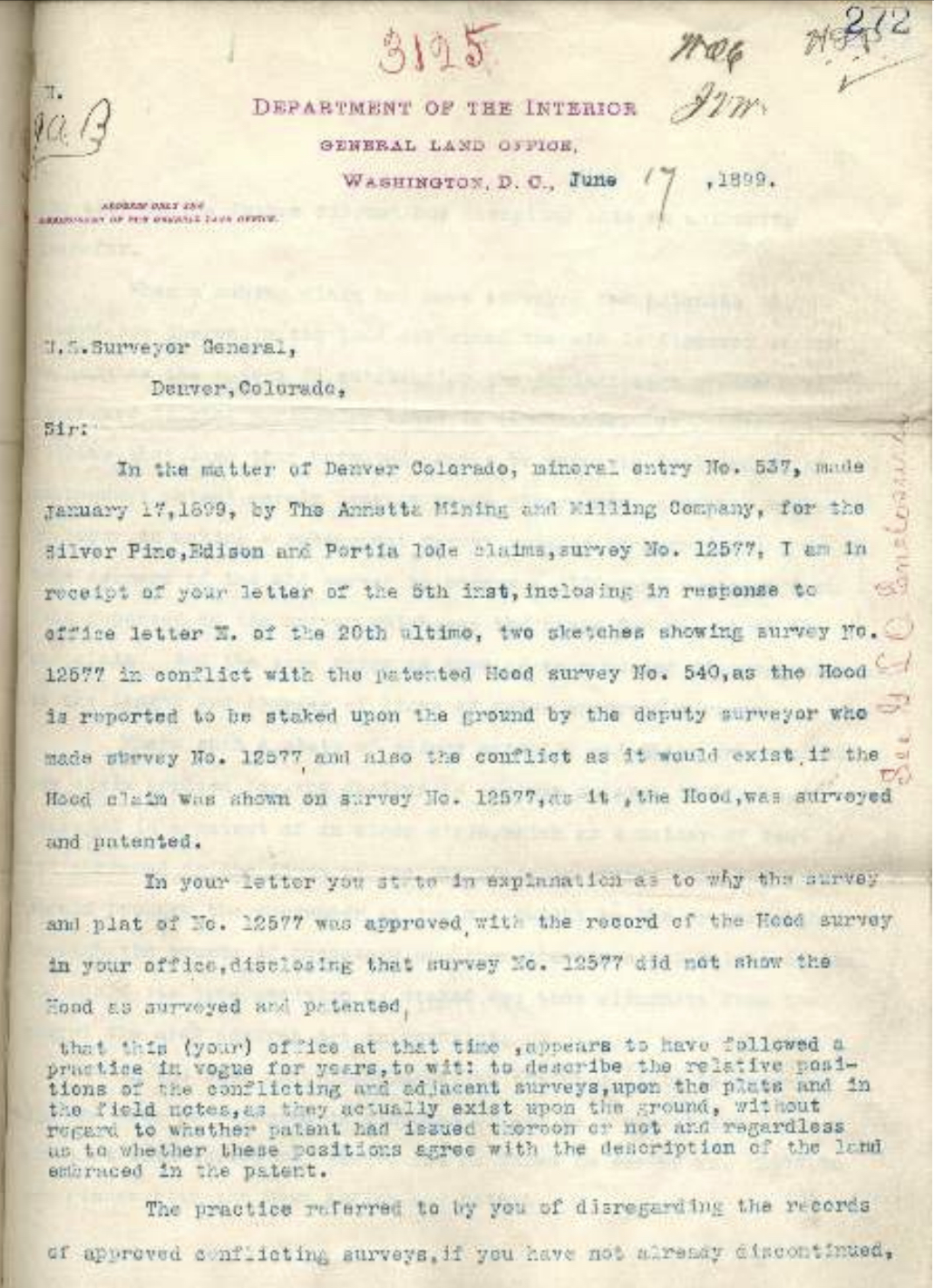
Binger-Hermann-MIneral-Survey-policy.jpg - Wandhlder9

Binger-Hermann-GLO-Letter4498.jpg - Wandhlder9

Binger Hermann policy Field-Notes-Mineral Survey.jpg - Wandhlder9
Field Notes Township 14 North, Range 3 West, Range 2 West No. 1038.pdf - Pazzo00
Young Mines Company Mineral Survey 3884-Plat 357239 2.pdf - Pazzo00

The-Mining-Reporter-1904 Mineral Survey.jpg - Pazzo00
Mining-Reporter-1904-What-The-Government.pdf - Pazzo00

Diagram of the State of Missouri - DPLA - a62950ad0b6dc7b24df34e6f4a936c40.jpg - DPLA bot
General Land Office Logo (23865923111).jpg - OptimusPrimeBot

Archibald Olive (1818-1903) land grant.jpg - Richard Arthur Norton (1958- )