Wikimedi'Òc
Modes d'emploi

Cet album fait partie des albums
Cet album photos contient les sous-albums suivants :


Clover Field NGM-v31-p567.jpg - Moverton

WheelLineIrrigation.JPG - H2O-C

Jeff Fennell - Devils Tower (by).jpg - Tmtriumph

Strip farming in Wisconsin, USA, 1957.jpg - Delirium

Powerlines travel south near Illiopolis Illinois.jpg - Dual Freq

SugartownFields.JPG - Dboggs2~commonswiki

AbanFarm.JPG - Just4Images

Mississinawa Township, Darke County, Ohio.jpg - Nyttend

Gettysburg National Military Park 23.JPG - Piotrus

Gettysburg National Military Park 25.JPG - Piotrus

Gettysburg National Military Park 61.JPG - Piotrus
Lone tree near Perrydale Oregon.JPG - Aboutmovies

Results of Fertilizer test field Tennessee Valley Authority 1942.gif - Ras67

Bundesarchiv Bild 137-032698, USA, Minnesota, Felder.jpg - BArchBot

Hawaii Hanalei Taro fields.png - Magix~commonswiki

OntarioSnowField.jpg - Bobjgalindo

Runoff of soil & fertilizer.jpg - Moreau1

Pluribus field wiki.jpg - Rodney Arthur
Pumpkin pollination4365.jpg - File Upload Bot (Magnus Manske)

Kenna New Mexico Ranch Gate.jpg - Leaflet
Spring Field in Bethel, Vermont.jpg - Flickr upload bot

Pickaway Settlements Battlesite.jpg - Nyttend

Bales of hay in a snow-covered field at dusk.JPG - Juliancolton

Panorama, bales of hay in a snow-covered field at dawn.jpg - Juliancolton

Bales of hay in an open field at sunset.JPG - Juliancolton

Woods along Newlove Road.jpg - Nyttend
Tunkhannock TOwnship, Monroe County, Midday.jpg - Flickr upload bot

Stateline Wind Project.jpg - Flickr upload bot

Windmills near Wasco, Oregon.jpg - Flickr upload bot

High Banks Works.jpg - Nyttend

Hopeton Earthworks overview from behind gate.jpg - Nyttend

Hopeton Earthworks wall.jpg - Nyttend

Gatch Site.jpg - Nyttend
Snow-Field-3938.jpg - Loadmaster

A field in Arna Township at sunrise.JPG - Jpwagner
Palouse hills - 9591.jpg - Jbarta
Old combine harvester.jpg - Ras67
South Eastern Washington State.tif - JGkatz
Plowed land 1r.jpg - Raghith

Locust Site overview.jpg - Nyttend

Hormel Stadium; Medford, MA.JPG - Emw

Narragansett Trail - "Shelter Cave Field" meadow with barn adjacent to "Trolley Pasture" meadow.jpg - Morrowlong
Pictures Kept by Supt. L. S. Bonnin, Cheyenne and Arapaho Agency - NARA - 268471.tif - US National Archives bot

Meadow at Crown Point Ferry Crossing.jpg - US Nessie

SUGAR MILL NEAR LAKE OKEECHOBEE - NARA - 544481.jpg - US National Archives bot
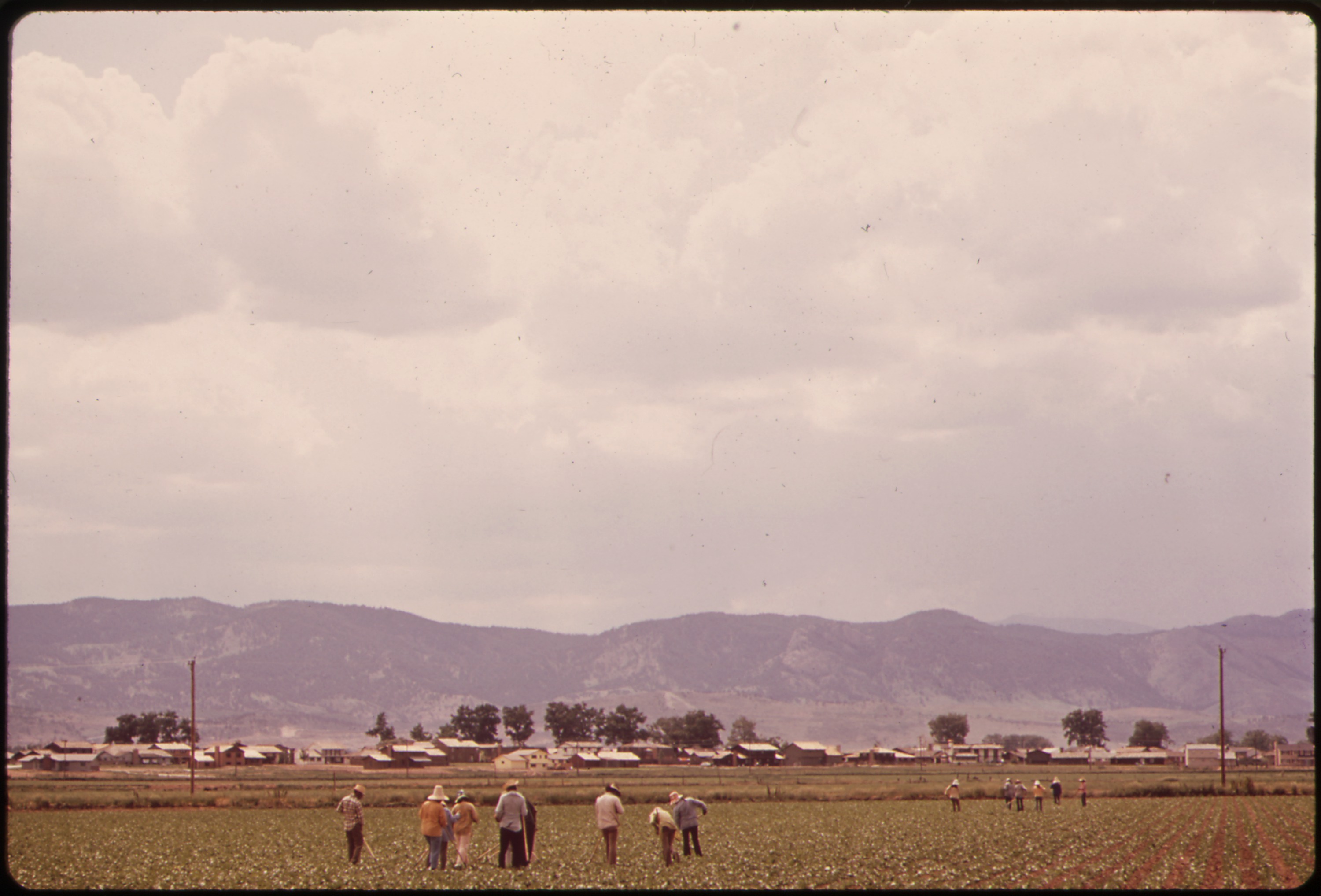
MIGRANT WORKERS IN FIELD - NARA - 543845.jpg - US National Archives bot

MIGRANTS WEED SUGAR BEETS FOR $2.00 AN HOUR - NARA - 543858.jpg - US National Archives bot

MIGRANT WORKERS WEED SUGAR BEETS FROM DAWN TO DUSK FOR $2.00 AN HOUR - NARA - 543862.jpg - US National Archives bot
Fields at the Riverton Site.jpg - Nyttend

Field - NARA - 528936.jpg - US National Archives bot

IRRIGATING AN ALFALFA FIELD ON AN EXPERIMENTAL FARM OPERATED BY EPA'S LAS VEGAS NATIONAL RESEARCH CENTER - NARA - 548950.jpg - US National Archives bot

IRRIGATING AN ALFALFA FIELD ON EXPERIMENTAL FARM OPERATED BY EPA'S LAS VEGAS NATIONAL RESEARCH CENTER - NARA - 548991.jpg - US National Archives bot

Sportsman's Park site 2011.jpg - Delaywaves

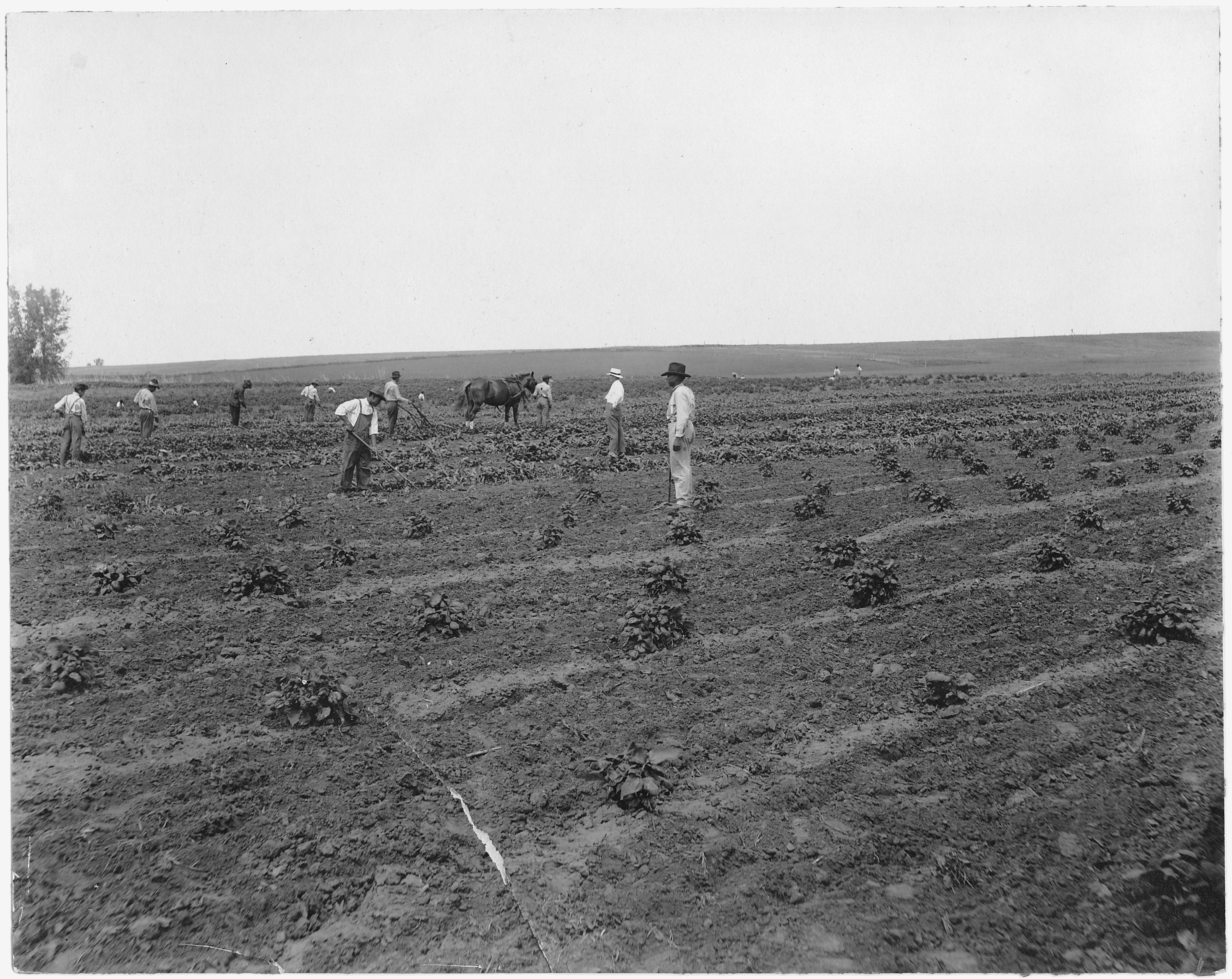
Aerial view of contour farming. Missouri - NARA - 286180.jpg - US National Archives bot

ON A FARM NEAR GRYGLA, A RETIRED FARMER SUPPLEMENTS HIS INCOME BY WORKING LAND BELONGING TO ANOTHER MAN - NARA - 554203.jpg - US National Archives bot

PLANTED FIELD IN ZEARING - NARA - 552466.jpg - US National Archives bot
JUST BEFORE RAIN-NEAR MURPHYSBORO - NARA - 552515.jpg - US National Archives bot

Leon Calico, president Indian Potato Growers' Assn., and largest Indian potato grower on Fort Hall reservation, in... - NARA - 298567.jpg - US National Archives bot

Henry Blackhawk, a new cow-man, looks for a hard winter - NARA - 298576.jpg - US National Archives bot

Field on north side of rad, running east and west, and on the west side of road running north and south on the east... - NARA - 298155.jpg - US National Archives bot

Field belonging to BUllis Parrott Estate, showing pint where water is taken from irrigating ditch, for distribution... - NARA - 298158.jpg - US National Archives bot

Field on Miles Ranch looking easterly (oats) - NARA - 298157.jpg - US National Archives bot

West end of Miles Ranch looking southeast - NARA - 298156.jpg - US National Archives bot

Shelby County, Iowa.... Detailed description, Shows Spring plowing going on. Usually a two-share mou . . . - NARA - 522438.jpg - US National Archives bot

Shelby County, Iowa.... Detailed description, Shows Spring plowing going on. Usually a two-share mou . . . - NARA - 522439.jpg - US National Archives bot

Shelby County, Iowa.... Detailed description, Shows Spring plowing going on. Usually a two-share mou . . . - NARA - 522440.jpg - US National Archives bot

Shelby County, Iowa.... Detailed description, The land is harrowed after the plowing. Tractors are c . . . - NARA - 522444.jpg - US National Archives bot

Shelby County, Iowa.... Detailed description, The land is harrowed after the plowing. Tractors are c . . . - NARA - 522441.jpg - US National Archives bot

Shelby County, Iowa.... Detailed description, The land is harrowed after the plowing. Tractors are c . . . - NARA - 522442.jpg - US National Archives bot

Shelby County, Iowa. Last year's corn stalks are sometimes piled in rows and burned on the land inst . . . - NARA - 522310.jpg - US National Archives bot

El Cerrito, San Miguel County, New Mexico. The staple crops in El Cerrito are corn, beans and alfal . . . - NARA - 521205.jpg - US National Archives bot

El Cerrito, San Miguel County, New Mexico. The staple crops in El Cerrito are corn, beans and alfal . . . - NARA - 521207.jpg - US National Archives bot

El Cerrito, San Miguel County, New Mexico. The staple crops in El Cerrito are corn, beans and alfal . . . - NARA - 521208.jpg - US National Archives bot

El Cerrito, San Miguel County, New Mexico. The staple crops in El Cerrito are corn, beans and alfal . . . - NARA - 521209.jpg - US National Archives bot

Newberry County, South Carolina. Contour plowing and terraces as see from 100' fire lookout tower on . . . - NARA - 522814.jpg - US National Archives bot
Pictures Kept by Supt. L. S. Bonnin, Cheyenne and Arapaho Agency - NARA - 268471.jpg - US National Archives bot

20111110-OC-AMW-0034 - Flickr - USDAgov.jpg - BotMultichillT

Square hay bales in long lines 1.jpg - Flickr upload bot
Square hay bales in long lines 2.jpg - Flickr upload bot

Square hay bales in long lines 3.jpg - Flickr upload bot

Haymaking 1 mowing.jpg - VortBot

Haymaking 3 windrows and bales.jpg - VortBot

Stubble field in Salt Creek Township.jpg - Nyttend
Geese in a field at Muscatatuck NWR.jpg - Nyttend

Newlove Road scene with woods.jpg - Nyttend

Burns Area Field (Harney County, Oregon scenic images) (harDA0032a).jpg - Smallbot

Whitehorse Ranch (Harney County, Oregon scenic images) (harDA0122).jpg - Smallbot

Mount Magazine from southeast.JPG - Fredlyfish4

Deer-field-1 - West Virginia - ForestWander.jpg - Forestwander Nature Photography upload bot

Deer-field-2 - West Virginia - ForestWander.jpg - Forestwander Nature Photography upload bot

Deer-field - West Virginia - ForestWander.jpg - Forestwander Nature Photography upload bot

Field-foliage-2 - West Virginia - ForestWander.jpg - Forestwander Nature Photography upload bot

Field-foliage - West Virginia - ForestWander.jpg - Forestwander Nature Photography upload bot

Field-sky-2 - West Virginia - ForestWander.jpg - Forestwander Nature Photography upload bot

Field-sky-3 - West Virginia - ForestWander.jpg - Forestwander Nature Photography upload bot

Field-sky - West Virginia - ForestWander.jpg - Forestwander Nature Photography upload bot

Old-fence-field - West Virginia - ForestWander.jpg - Forestwander Nature Photography upload bot

Barn-field-fall-trees - West Virginia - ForestWander.jpg - Forestwander Nature Photography upload bot

Fall-barn - West Virginia - ForestWander.jpg - Forestwander Nature Photography upload bot

Spring-deer-field - West Virginia - ForestWander.jpg - Forestwander Nature Photography upload bot

Spring-sunset-mountain-field - West Virginia - ForestWander.jpg - Forestwander Nature Photography upload bot

Flickr - Nicholas T - Valley View (1).jpg - Matanya

Flickr - Nicholas T - Valley View (2).jpg - Matanya

Flickr - Nicholas T - Rural Route.jpg - Matanya

Flickr - Nicholas T - Country Road.jpg - Matanya

Flickr - Nicholas T - Farming Valley (2).jpg - Matanya

Flickr - Nicholas T - Road Less Traveled.jpg - Matanya

Flickr - Nicholas T - Roundtop.jpg - Matanya

Evening-country-field-highfreeland-wv - West Virginia - ForestWander.jpg - Forestwander Nature Photography upload bot

Whitetail-deer-spring-morning-field - West Virginia - ForestWander.jpg - Forestwander Nature Photography upload bot

Swan Island Site.jpg - Nyttend

Stoner Site fields.jpg - Nyttend

NRCSDC01013 - District of Columbia (1781)(NRCS Photo Gallery).jpg - Smallbot
NRCSDC01013 - District of Columbia (1781)(NRCS Photo Gallery).tif - Smallbot

NRCSDE01004 - Delaware (1801)(NRCS Photo Gallery).jpg - Smallbot

NRCSFL07008 - Florida (715590)(NRCS Photo Gallery).jpg - Smallbot
NRCSFL07008 - Florida (715590)(NRCS Photo Gallery).tif - Smallbot

NRCSIA99132 - Iowa (2967)(NRCS Photo Gallery).jpg - Smallbot

NRCSIA99134 - Iowa (2969)(NRCS Photo Gallery).jpg - Smallbot

NRCSIA99148 - Iowa (2997)(NRCS Photo Gallery).jpg - Smallbot

NRCSIA99162 - Iowa (3025)(NRCS Photo Gallery).jpg - Smallbot

NRCSTN83003 - Tennessee (6251)(NRCS Photo Gallery).jpg - Smallbot

NRCSTN83008 - Tennessee (6261)(NRCS Photo Gallery).jpg - Smallbot

Barn grass mountains fence.jpg - Fæ

Wheat field near Mitchell, Nebraska - NARA - 294471.jpg - Denniss

Rhinebeck at Sunrise.JPG - Mojha MacDowell

2013-05-06 18 47 12 View across a plowed field in Point Mountain Reservation.jpg - Famartin

Fields from the Cobb Bridge at Paducah.jpg - Nyttend

Megan Mailloux looking across field (5413351700).jpg - File Upload Bot (Magnus Manske)

Farming and maintaining terraces.jpg - Tortie tude

Field or pasture1a34437v.jpg - Slowking4

Field with farm equipment in distance1a34446v.jpg - Slowking4

Farmland in the Catskill country1a34567v.jpg - Slowking4

Grass field west of Mount Pisgah.JPG - Jsayre64

Photograph of a Man and a Dog in a Field - NARA - 7829567.jpg - US National Archives bot

Photograph of a Man Standing in a Field - NARA - 7829565.jpg - US National Archives bot

Photograph of Two Horses in a Field - NARA - 7829566.jpg - US National Archives bot

Storm clouds over a field.jpg - Supernerd11

Field in Forks with elk.JPG - James9777

Spring-sunset-mountain-field-clipped.jpg - Micheletb
Collard green field in North Centre Township, Columbia County, Pennsylvania.JPG - Jakec

Closeup of field in Mahoning Township, Montour County, Pennsylvania.JPG - Jakec

Field in Derry Township, Montour County, Pennsylvania.JPG - Jakec

Field in Madison Township, Columbia County, Pennsylvania.JPG - Jakec

Field in Roaring Creek Township, Columbia County, Pennsylvania 1.JPG - Jakec

Field in Roaring Creek Township, Columbia County, Pennsylvania 2.JPG - Jakec

Rural farmland in America.jpg - Carolhi
Trees and field in Franklin Township, Columbia County, Pennsylvania.JPG - Jakec
Susquehanna River in late March.JPG - Jakec

Two trees in a field in April.JPG - Jakec

Cows in a field in Luzerne County, Pennsylvania 1.JPG - Jakec

Cows in a field in Luzerne County, Pennsylvania 2.JPG - Jakec

Kelso-field-tn1.jpg - BrineStans

Old-Salem-fields-tn1.jpg - BrineStans

Field in Dorrance Township, Luzerne County, Pennsylvania.JPG - Jakec

Catskill Escarpment from US 9 in Livingston, NY, with crepuscular rays.jpg - Daniel Case

Soils of southern New Jersey and their uses (1918) (14587478790).jpg - Fæ

Soils of southern New Jersey and their uses (1918) (14587546268).jpg - Fæ

Bright Winter Morning - panoramio.jpg - Panoramio upload bot

Lone Tree - panoramio.jpg - Panoramio upload bot

Winter Morning with a Border Collie - panoramio.jpg - Panoramio upload bot

2015-10-19 15 13 46 Field with brown grass along Old Ox Road in Sterling, Virginia.jpg - Famartin

Quarry Park and Nature Preserve, Waite Park - St. Cloud, Minnesota (24417686506).jpg - Tony Webster

Underground Railroad Tour, landscape (20981427594).jpg - Ser Amantio di Nicolao

FieldatStarkCityMo.jpg - FastilyClone

NAPI Alfalfa.jpg - Navajo Agricultural Products Industry

FieldVirginia2.jpg - Atcovi

Field1.jpg - 20watsle

Farm West of Dodgeville - panoramio.jpg - Panoramio upload bot

2016-06-18 09 27 05 Fields along West Virginia State Route 46 in Cross, Mineral County, West Virginia.jpg - Famartin

2016-06-18 13 10 15 View northeast across fields and a pond from Maryland State Route 956 (Patriot Parkway) near Bel Air in Allegany County, Maryland.jpg - Famartin

2016-06-27 08 25 19 View west towards Walnut Mountain in the Southwest Mountains of Albemarle County, Virginia from Virginia State Route 231 (Gordonsville Road) near Virginia State Secondary Route 615 (Lindsay Road).jpg - Famartin

2016-06-27 08 25 21 View west-northwest towards the Southwest Mountains of Albemarle County, Virginia from Virginia State Route 231 (Gordonsville Road) near Virginia State Secondary Route 615 (Lindsay Road).jpg - Famartin

2016-06-27 08 25 24 View northwest towards Peters Mountain in the Southwest Mountains of Albemarle County, Virginia from Virginia State Route 231 (Gordonsville Road) near Virginia State Secondary Route 615 (Lindsay Road).jpg - Famartin

2016-06-27 08 25 27 View north towards the Southwest Mountains of Albemarle County, Virginia from Virginia State Route 231 (Gordonsville Road) near Virginia State Secondary Route 615 (Lindsay Road).jpg - Famartin

2016-06-27 08 25 53 Panorma northwestward towards Walnut Mountain and Peters Mountain in the Southwest Mountains of Albemarle County, Virginia from Virginia State Route 231 (Gordonsville Road) near Virginia State Secondary Route 615 (Lindsay Road).jpg - Famartin

"A Florida Backyard in Mid Winter" (10836942803).jpg - Fæ
Future Farmers of America picking tomatoes- Palmetto, Florida (8630398003).jpg - Fæ

Stringtown Rd on Strawberry Ride in Germantown MD - panoramio.jpg - Panoramio upload bot

High Grain - Worton (Betterton) MD - panoramio.jpg - Panoramio upload bot

2016-07-03 17 42 07 Altostratus and a few low cumulus above a field of grass along Old Ox Road (Virginia State Secondary Route 606) in Sterling, Loudoun County, Virginia.jpg - Famartin

2016-07-17 08 15 21 Low clouds breaking up near Old Ox Road (Virginia State Secondary Route 606) in Sterling, Loudoun County, Virginia.jpg - Famartin
2016-07-29 12 44 00 Rocky field at the intersection of Maryland State Route 68 (Clear Spring Road) at Cedar Ridge Road in Pinesburg, Washington County, Maryland.jpg - Famartin
2016-07-29 12 44 15 Rocky field at the intersection of Maryland State Route 68 (Clear Spring Road) at Cedar Ridge Road in Pinesburg, Washington County, Maryland.jpg - Famartin

Study in Blue and Green, ~12000-12098 Hieber Road Freedom Township, Michigan - panoramio.jpg - Panoramio upload bot

2016-08-05 07 55 49 Field surrounded by Black Locust saplings between NW 101 Terrace and NW Polo Drive in Kansas City, Platte County, Missouri.jpg - Famartin

2016-08-20 10 21 14 View west across farm fields from Maryland State Route 27 (Manchester Road) just north of Sullivan Road in Cranberry, Carroll County, Maryland.jpg - Famartin

2016-08-20 10 21 17 View northwest across a farm from Maryland State Route 27 (Manchester Road) just north of Sullivan Road in Cranberry, Carroll County, Maryland.jpg - Famartin

2016-08-20 10 21 19 View north-northwest across farm fields and a farm pond from Maryland State Route 27 (Manchester Road) just north of Sullivan Road in Cranberry, Carroll County, Maryland.jpg - Famartin

2016-08-20 10 22 14 Panorama northwest across a farm from Maryland State Route 27 (Manchester Road) just north of Sullivan Road in Cranberry, Carroll County, Maryland.jpg - Famartin

2016-08-20 11 20 13 View west along Harvey Yingling Road just west of Maryland State Route 668 (Boswells Drive) in Wentz, Carroll County, Maryland.jpg - Famartin

St. Bridget's Cemetery - panoramio.jpg - Panoramio upload bot

Autumn field in Michigan (30162633516).jpg - Fæ
Sediment runoff NRCS 2016a.jpg - Moreau1

20140402-APHIS-UNK-0011 (13592610573).jpg - Artix Kreiger 2

Snow-covered glacial erratic in field off NY 208, Wallkill, NY.jpg - Daniel Case

Ford tractor demonstration LCCN2016823779.jpg - Fæ

Ford tractor demonstration LCCN2016823780.jpg - Fæ

Ford tractor demonstration LCCN2016823782.jpg - Fæ

Ford tractor demonstration LCCN2016823783.jpg - Fæ

Ford tractor demonstration LOC npcc.05090.jpg - Fæ

Ford tractor demonstration LOC npcc.05091.jpg - Fæ

Ford tractor demonstration LOC npcc.05092.jpg - Fæ

Ford tractor demonstration LOC npcc.05093.jpg - Fæ

Ford tractor demonstration LOC npcc.05094.jpg - Fæ

FORD TRACTOR LCCN2016867728.jpg - Fæ
FORD TRACTOR LCCN2016867729.jpg - Fæ
FORD TRACTOR LCCN2016867728.tif - Fæ
FORD TRACTOR LCCN2016867729.tif - Fæ

Monmouth Battlefield State Park First Day Hike 2015 open fields turn.jpg - Jonathan Schilling

Monmouth Battlefield State Park First Day Hike 2016 ahead of the pack.jpg - Jonathan Schilling

2018-06-03 18 47 20 A field under a deck of low clouds along Old Ox Road (Virginia State Route 606) in the Dulles section of Sterling, Loudoun County, Virginia.jpg - Famartin
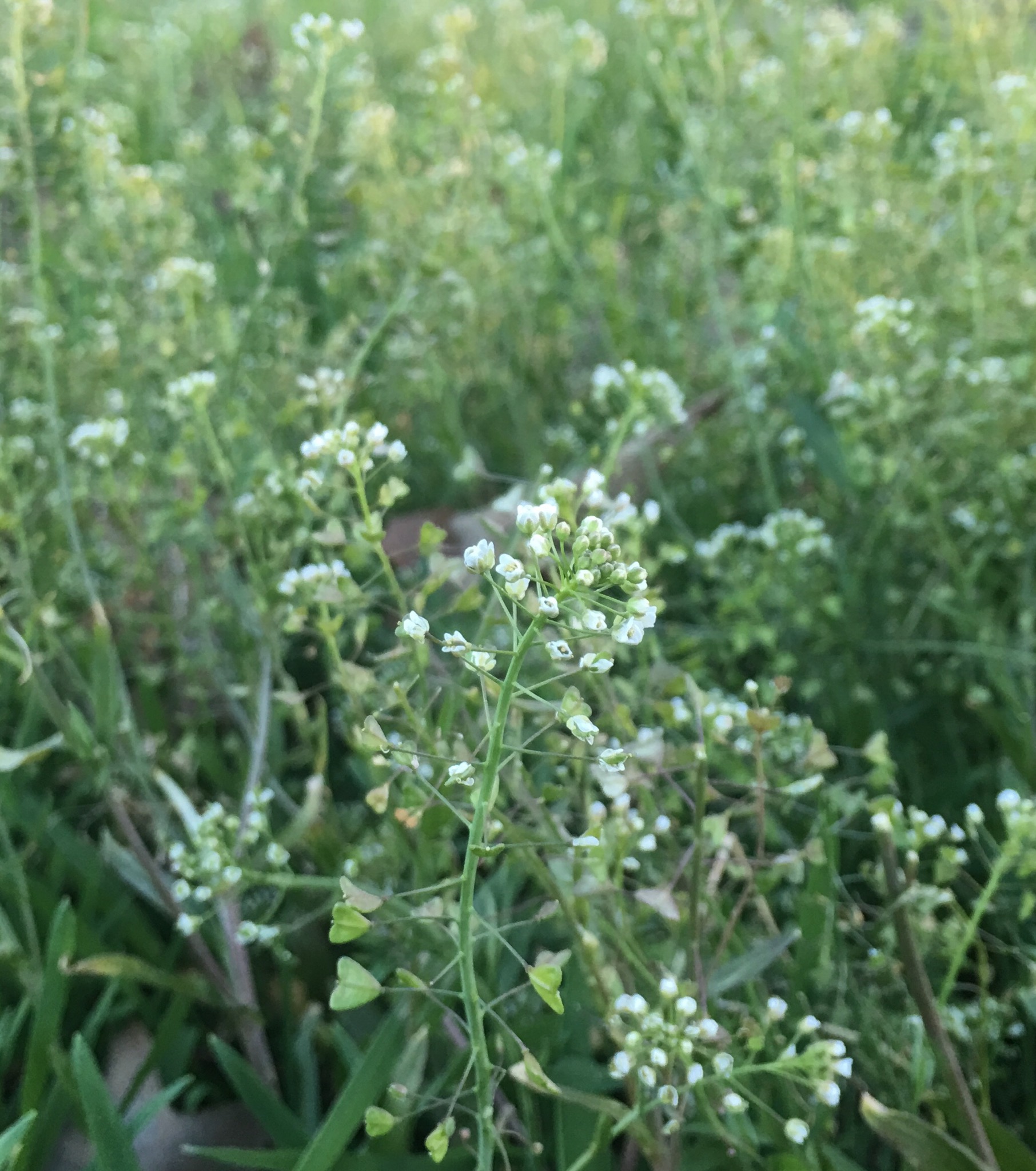
A Field of Shepherd’s-purse.jpg - SaltySemanticSchmuck

Photos-OutdoorImage-AdobeStock-Fiedl1.jpg - Johns-book

Mule Day Grounds.jpg - The Bushranger

Maine fall 3 (3030347948).jpg - Itti

Pastoral scenery along Lake Road in Porter, New York - "Cloverfield West" - 20200524.jpg - Andre Carrotflower
NY 14, Lyons, New York - 20200611.jpg - Andre Carrotflower

Alapaha River Wildlife Management Area dove field.jpg - Mjrmtg
Calvary, Field where Mule Day is held.jpg - Mjrmtg
Saulsbury fields, May 2019.jpg - NovumChase

2020-10-27 11 17 14 Field along Gloucester County Route 553 (Buck Road) near Gloucester County Route 610 (Whig Lane) in Elk Township, Gloucester County, New Jersey.jpg - Famartin

2020-10-27 11 17 17 Field along Gloucester County Route 553 (Buck Road) near Gloucester County Route 610 (Whig Lane) in Elk Township, Gloucester County, New Jersey.jpg - Famartin

(EPA Science WED 2) 412-DSP-2-WEDarials 071.jpg - DPLA - a8d3f54d9fa6dda58805fb4c9d94739a.jpg - DPLA bot

Farm house, fields and a tower, Alderwood Manor, Washington, ca 1925 (WASTATE 1776).jpg - BMacZeroBot

WestTexasField.jpg - Illuminatiscott

Planted field in Lula, Mississippi, on June 2, 2006.jpg - Chase me ladies, I'm the Cavalry

Early springtime rural roadside view, Easter Sunday, Town of Middlebury, New York - 20210404.jpg - Andre Carrotflower

Pastoral scenery off US 62, Dayton, New York - 20210418.jpg - Andre Carrotflower

Late summer rural landscape, off Sisson Highway, Town of Collins, New York - 20210824.jpg - Andre Carrotflower

The Wide-Open Spaces of Yates County, Benton, New York - 20220311.jpg - Andre Carrotflower

Sports Field at Cape Fear Academy.jpg - DiscoA340

America (6154386431).jpg - Юрий Д.К.

J.R. Alford Greenway.jpg - The Bushranger

Pope Farm Conservancy - panoramio - Corey Coyle (4).jpg - Panoramio upload bot

Pope Farm Conservancy - panoramio - Corey Coyle (5).jpg - Panoramio upload bot