Wikimedi'Òc
Modes d'emploi

Cet album fait partie des albums


Washington State Desert Pylons3.jpg - FlickrLickr

Washington State Desert Pylons4.jpg - FlickrLickr
Three Phase Electric Power Transmission.jpg - Svjo
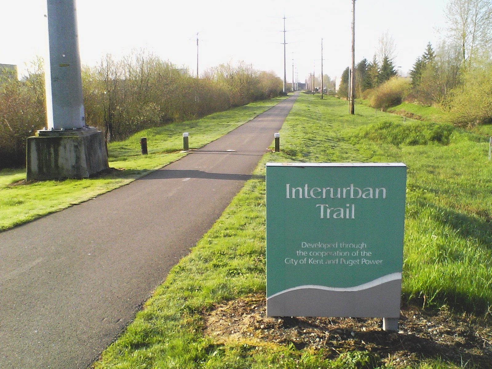
Interurban-Trail-Sign-WA.jpg - Rotatebot

Grand Coulee Dam no forebay.jpg - Veikk0.ma

Seattle - NEMCO warehouse 01.jpg - Jmabel

Seattle - power lines near Ferdinand P-Patch.jpg - Jmabel
Sound Transit SODO Station.jpg - Atomic Taco
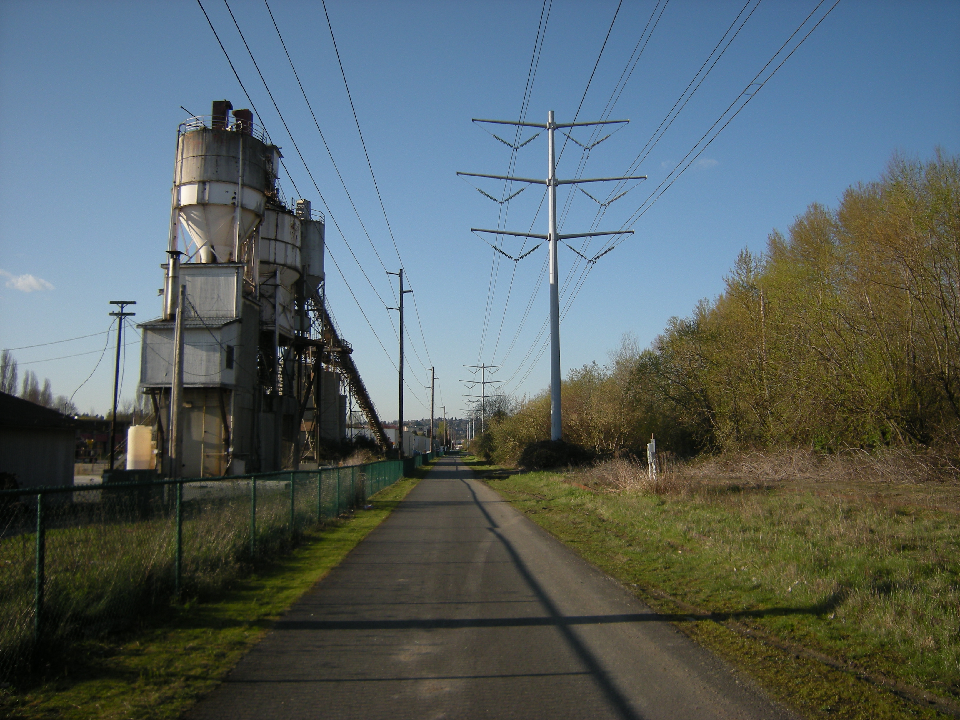
Tukwila - old cement plant on W. Valley Rd 01.jpg - Jmabel

Auburn, Washington - Interurban Trail north from W. Main St.jpg - Jmabel

Centennial Trail - power lines 01.jpg - Jmabel

Hay-wagon and railway near Snohomish, WA.jpg - Jmabel
High Voltage Lines in Washington State.tif - JGkatz

Quincy Lake 2025.JPG - Wsiegmund

Pinus ponderosa 8034.JPG - Wsiegmund

Wind farm 7967.JPG - Wsiegmund

Seattle - 13th & Snoqualmie P-Patch 01.jpg - Jmabel

Seattle - 13th & Snoqualmie P-Patch 02.jpg - Jmabel

Chief Joseph Dam, Washington.jpg - File Upload Bot (Magnus Manske)
TRANSMISSION LINES BETWEEN DIABLO AND GORGE; CONSTRUCTION DETAIL OF TOWER STRUCTURE, 1989. - Skagit Power Development, Gorge High Dam, On Skagit River, 2.9 miles upstream HAER WASH,37-NEHA.V,1-C-10.tif - Fæ
Photocopy of photograph (original print located in WWP Building, Engineering Vault, Spokane, Washington). Photographer unknown, May 7, 1913. GENERAL VIEW OF LITTLE FALLS TIE HAER WASH,33-WELPI.V,1-12.tif - Fæ
Photocopy of photograph (original print located in WWP Building, Engineering Vault, Spokane, Washington). Photographer unknown, ca. Fall 1910. GENERAL VIEW OF LITTLE FALLS HAER WASH,33-WELPI.V,1-10.tif - Fæ
VIEW OF NORTHWEST ELEVATIONS OF LITTLE FALLS TIE LINE TOWERS NO. 59 AND NO. 60, EXAMPLE OF TRANSPOSITION TOWERS. LOOKING SOUTHEAST. - Little Falls Tie Line Towers, Near Little HAER WASH,33-WELPI.V,1-5.tif - Fæ
VIEW OF SOUTHEAST ELEVATION OF LITTLE FALLS TIE LINE TOWER NO. 79. LOOKING NORTHWEST. - Little Falls Tie Line Towers, Near Little Dam Falls on Spokane River, Wellpinit, HAER WASH,33-WELPI.V,1-6.tif - Fæ
VIEW OF WEST ELEVATION OF LITTLE FALLS TIE LINE TOWER NO. 23, OSPREY NEST ON TOWER TOP. LOOKING EAST - Little Falls Tie Line Towers, Near Little Dam Falls on Spokane River, HAER WASH,33-WELPI.V,1-2.tif - Fæ
VIEW OF SOUTHEAST ELEVATION OF LITTLE FALLS TIE LINE TOWER NO. 130. LOOKING NORTHWEST. - Little Falls Tie Line Towers, Near Little Dam Falls on Spokane River, Wellpinit, HAER WASH,33-WELPI.V,1-7.tif - Fæ
VIEW OF SOUTHEAST ELEVATION OF LITTLE FALLS TIE LINE TOWER NO. 185. LOOKING NORTHWEST. - Little Falls Tie Line Towers, Near Little Dam Falls on Spokane River, Wellpinit, HAER WASH,33-WELPI.V,1-8.tif - Fæ
Photocopy of photograph (original print located in WWP Building, Engineering Vault, Spokane, Washington). Photographer unknown, ca. Fall 1910. GENERAL VIEW OF LITTLE FALLS TIE HAER WASH,33-WELPI.V,1-9.tif - Fæ
VIEW OF NORTHWEST CORNER OF LITTLE FALLS TIE LINE TOWER NO. 23, STANDARD PEAK TOWER. LOOKING SOUTHEAST. - Little Falls Tie Line Towers, Near Little Dam Falls on Spokane River, HAER WASH,33-WELPI.V,1-3.tif - Fæ
VIEW OF SOUTHEAST CORNER OF LITTLE FALLS TIE LINE TOWER NO. 41, OSPREY NEST ON TOWER TOP. LOOKING NORTHWEST. - Little Falls Tie Line Towers, Near Little Dam Falls on Spokane HAER WASH,33-WELPI.V,1-4.tif - Fæ
Photocopy of photograph (original print located in WWP Building, Engineering Vault, Spokane, Washington). Photographer unknown, ca. May 7, 1913. GENERAL VIEW OF LITTLE FALLS HAER WASH,33-WELPI.V,1-11.tif - Fæ
View of north tower, facing northwest from dike on north bank of the Columbia River. - Pasco-Kennewick Transmission Line, Columbia River Crossing Towers, Columbia Drive and Gum HAER WASH,3-KENN,1-1.tif - Fæ
View of north tower with detail of cross arms, facing north. - Pasco-Kennewick Transmission Line, Columbia River Crossing Towers, Columbia Drive and Gum Street, Kennewick, Benton HAER WASH,3-KENN,1-2.tif - Fæ
View of south tower, facing north-northeast from south bank of the Columbia River. Center tower and north tower in background, lower right. - Pasco-Kennewick Transmission Line, HAER WASH,3-KENN,1-5.tif - Fæ
View of north tower, facing north across the main channel of the Columbus River from Clover Island. - Pasco-Kennewick Transmission Line, Columbia River Crossing Towers, Columbia HAER WASH,3-KENN,1-3.tif - Fæ
View of south tower, facing south from Clover Island, across boat moorage channel. - Pasco-Kennewick Transmission Line, Columbia River Crossing Towers, Columbia Drive and Gum HAER WASH,3-KENN,1-6.tif - Fæ
View of center tower at Clover Island, facing northeast. Pasco-Kennewick automobile bridge in background, lower right. - Pasco-Kennewick Transmission Line, Columbia River Crossing HAER WASH,3-KENN,1-4.tif - Fæ
View of 500,000 volt spreading yard that transfers power from underground cable, from Third Powerhouse, to overhead line; the towers are pipe-type transformer towers. Looking HAER WASH,13-GRACO,1B-27.tif - Fæ

Bonneville Power Administration (4436168501).jpg - Bomazi

Power lines near Snoqualmie Falls 01.jpg - Jmabel

Klickitat Valley Windmills - U.S. Route 97 (24548603724).jpg - Tony Webster

Yicol 10b (20612264951).jpg - Vanished Account Byeznhpyxeuztibuo

Yicol 11b (19984791523).jpg - Vanished Account Byeznhpyxeuztibuo

Yicol 12b (20605667345).jpg - Vanished Account Byeznhpyxeuztibuo

Yigco 5b (7686369304).jpg - Vanished Account Byeznhpyxeuztibuo

Grand Coulee Dam Panorama - Flickr - brewbooks.jpg - Josve05a
New overhead transmission line construction - Flickr - brewbooks.jpg - Josve05a

Power Grid - Flickr - brewbooks.jpg - Josve05a

Power Grid - Flickr - brewbooks (1).jpg - Josve05a
500kV 3-Phase Transmission Lines.png - ThreePhaseAC
High voltage transmission tower and lines. Auburn WA.jpg - Ron Clausen

Workers installing tower at Boundary Dam, 1967 (36871642215).jpg - Jmabel

Power line near Sedro Wooley, WA. (36441413433).jpg - Artix Kreiger 2

Slater Road entrance to Noocksac Dike Trail (32616252903).jpg - Artix Kreiger 2

Camping at a small RV park in Grand Coulee with a nice little tent area. (37053460345).jpg - Artix Kreiger 2

Power lines near Grand Coulee Dam (36245550293).jpg - Artix Kreiger 2

Power lines near road to Wilbur from Grand Coulee Dam (37053112515).jpg - Artix Kreiger 2

Newhalem, WA. 1993 (9149273790).jpg - Artix Kreiger 2

Power lines at Newhalem, WA. (4937411198).jpg - Artix Kreiger 2

Looking through power line near Steven's Pass (1770334310).jpg - Artix Kreiger 2

Bare dirt field sometimes called summer fallow (3936747490).jpg - Artix Kreiger 2

Newhalem (1649973716).jpg - Artix Kreiger 2

Power line marching off north of McNary Dam (3571051463).jpg - Artix Kreiger 2

McNary Dam (10488717786).jpg - Artix Kreiger 2

Interurban Trail south of Seattle (10899732403).jpg - Artix Kreiger 2

Intururban Trail near Auburn (10488066906).jpg - Artix Kreiger 2

Interurban Trail south of Seattle (10899475096).jpg - Artix Kreiger 2

Interurban Trail south of Seattle, 2010 (33281092253).jpg - Artix Kreiger 2

Interurban Trail south of Seattle (10899576104).jpg - Artix Kreiger 2

Interurban Trail (10488065646).jpg - Artix Kreiger 2

Along Iron Horse Trail. I-90 below. (10508311905).jpg - Artix Kreiger 2

Rocky Reach Dam Powerlines on the Columbia River.jpg - ThayneT

East Wenatchee Washington- NW.jpg - ThayneT

Pylon at Hannegan Road near Bellingham, Washington US 2017 A.jpg - Te750iv

Pylon at Hannegan Road near Bellingham, Washington US 2017 B.jpg - Te750iv

Powerlines Along Ediz Hook (30799942190).jpg - Tyler ser Noche

Coming 'Round The Mountain (3566134782).jpg - Jon Kolbert

Auburn, Washington - power lines perpendicular to Green River Road SE - 01.jpg - Jmabel

Auburn, Washington - power lines perpendicular to Green River Road SE - 02.jpg - Jmabel

Auburn, Washington - power lines perpendicular to Green River Road SE - 03.jpg - Jmabel

Auburn, Washington - power lines perpendicular to Green River Road SE - 04.jpg - Jmabel

Auburn, Washington - power lines perpendicular to Green River Road SE - 05.jpg - Jmabel

Auburn, Washington - power lines perpendicular to Green River Road SE - 06.jpg - Jmabel

Machias, WA - power lines seen from Centennial Trail 01.jpg - Jmabel

Looking south on Chief Sealth Trail near S. Brandon St. 01.jpg - Jmabel

Looking south on Chief Sealth Trail near S. Brandon St. 02.jpg - Jmabel

Looking south on Chief Sealth Trail near S. Brandon St. 03.jpg - Jmabel

Looking south on Chief Sealth Trail near S. Brandon St. 04.jpg - Jmabel
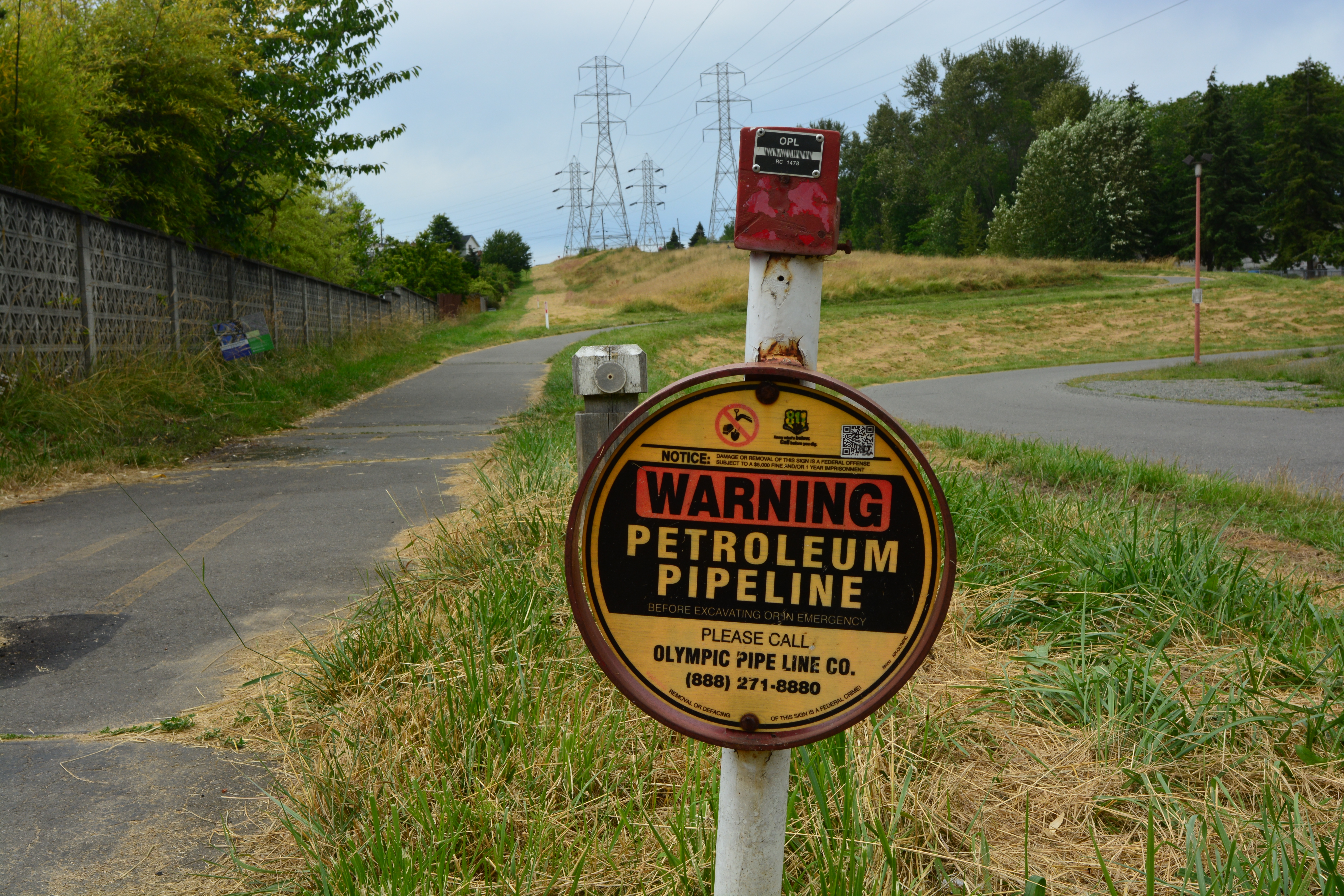
Petroleum pipeline sign along Chief Sealth Trail.jpg - Jmabel

Looking north on the Chief Sealth Trail toward VA Hospital.jpg - Jmabel

Looking north on the Chief Sealth Trail toward VA Hospital (cropped).jpg - Jmabel

E4252 - DPLA - f20ee561819f9048472f4027fcb2ed82.jpg - DPLA bot

E4269 - DPLA - 72596f9ed62f744194ab8c05bd07924e.jpg - DPLA bot

E569 - DPLA - 16a28d4de0f6b59e3335024ba3fe832b.jpg - DPLA bot
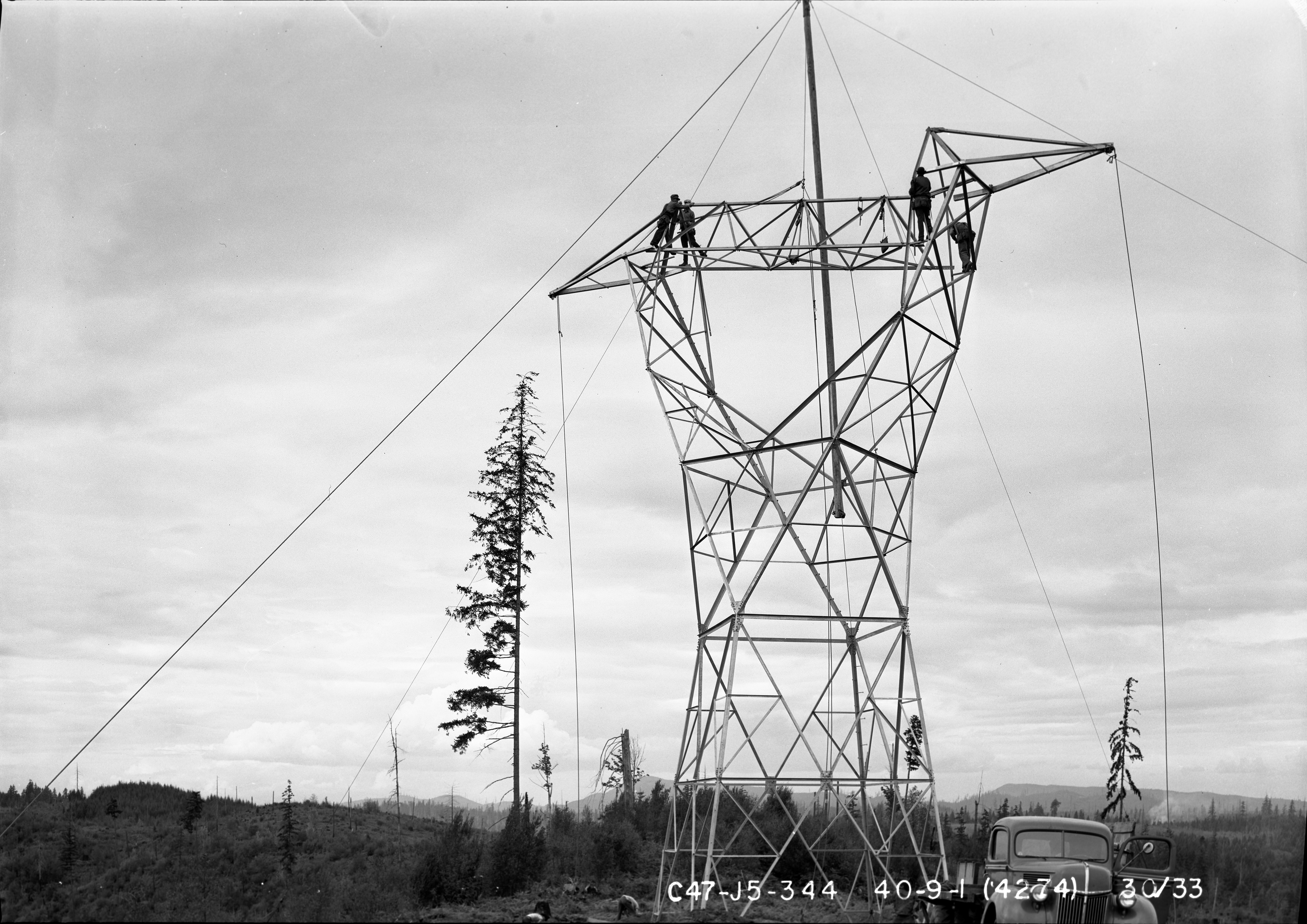
E4274 - DPLA - 5a8c969a3564a7e53bffab6eefd70bbd.jpg - DPLA bot
Transmission line tower near camp no 1 and incline railway near Dieringer, November 2, 1911 (SPWS 86).jpg - BMacZeroBot

Umatilla Bridges, Apr 17.jpg - An Errant Knight
Sound Transit SODO Station (cropped).jpg - Another Believer

Electricity pylon in Kent, Washington - 1.jpg - Roc0ast3r

Electricity pylon in Kent, Washington - 2.jpg - Roc0ast3r

Electricity pylon in Kent, Washington - 3.jpg - Roc0ast3r

Elmer Severin in pumpkin patch, 1960.jpg - Jmabel

Electricity pylon in Seattle West Ewing Mini Park 01.jpg - Jmabel

Looking up at electricity pylon, Seattle - West Ewing Mini Park.jpg - Jmabel

Pylons for Seattle City Light power lines across the Skagit River at Corkindale.jpg - Jmabel

Skagit River - Eagle's nest on power pylon.jpg - Jmabel

Skagit River southwest of Corkindale 04.jpg - Jmabel