Wikimedi'Òc
Modes d'emploi

Cet album fait partie des albums
Cet album photos contient les sous-albums suivants :


KentGeologyWealdenDome 2.svg - ClemRutter

Image-KentGeologyWealdenDome 1.svg - AnonMoos

KentGeologyWealdenDome.svg - ClemRutter

KentGeologyWealdenDomeSimple.svg - ClemRutter

Kent East Sussex Downs.svg - ClemRutter
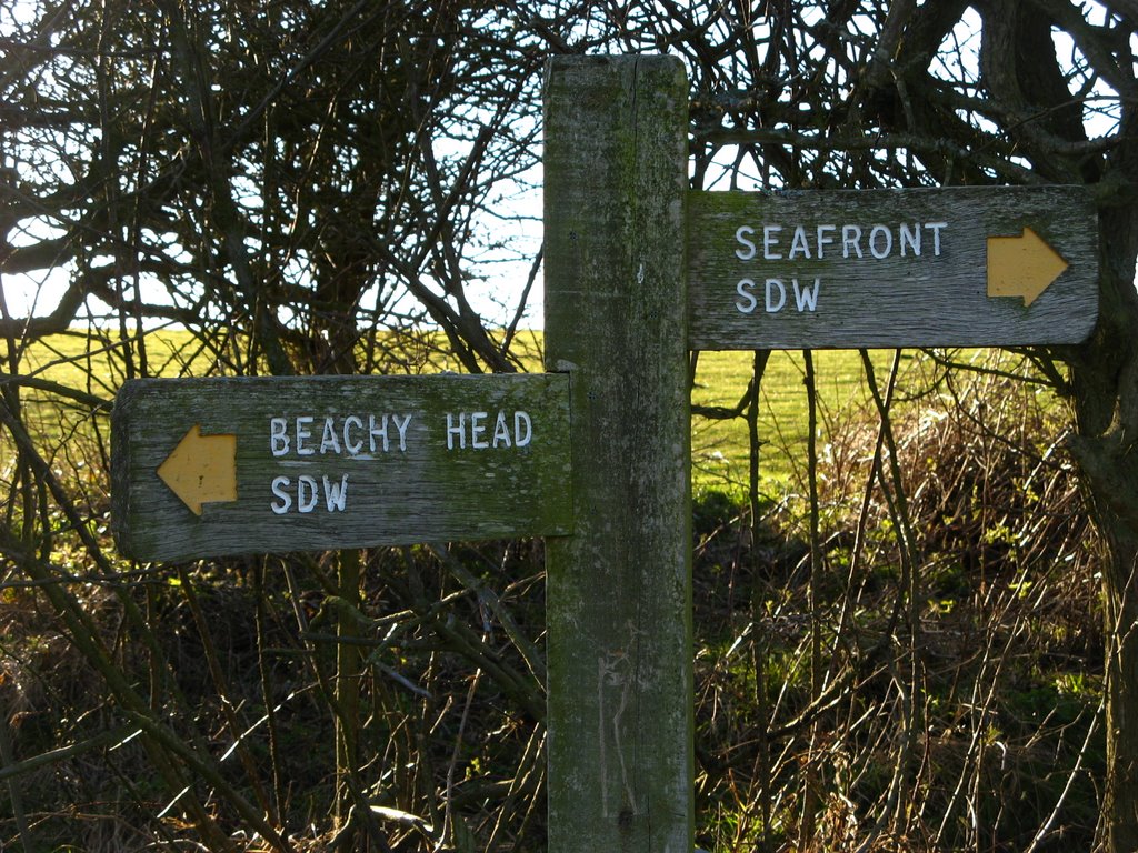
Trailmark on the South Downs Way, Sussex, UK.jpg - Donarreiskoffer

Colonel Body Memorial Lakes, Pett Level, East Sussex - geograph.org.uk - 1094.jpg - GeographBot

Freshfield Lane Brickworks - geograph.org.uk - 24703.jpg - GeographBot

Marina at Newhaven - geograph.org.uk - 23936.jpg - GeographBot

Towards Firle - geograph.org.uk - 3182.jpg - GeographBot

Stone Farm rocks - geograph.org.uk - 23464.jpg - GeographBot
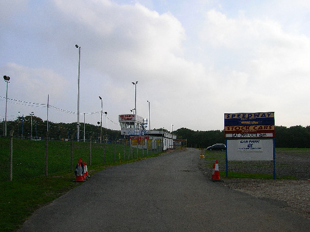
Arlington Stadium - geograph.org.uk - 62671.jpg - GeographBot

Beach and Groynes, Pett levels - geograph.org.uk - 69677.jpg - GeographBot

Fishing Pools at Mill Brook - geograph.org.uk - 36462.jpg - GeographBot

Embankment, Pett Levels - geograph.org.uk - 69675.jpg - GeographBot

Fairlight Head - geograph.org.uk - 69684.jpg - GeographBot

Ham Road Orphanage - geograph.org.uk - 60852.jpg - GeographBot

Mill Hill, Shoreham - geograph.org.uk - 47967.jpg - GeographBot

National Cycle Route 21 south of Mayfield - geograph.org.uk - 47264.jpg - GeographBot

Nate Wood - geograph.org.uk - 62683.jpg - GeographBot

Roman road near Holtye - geograph.org.uk - 48316.jpg - GeographBot

View from first car park on Devil's Dyke Road - geograph.org.uk - 36801.jpg - GeographBot

Sloping and curved sea wall - geograph.org.uk - 69680.jpg - GeographBot

Small holding development 1957, Old Town, Eastbourne - geograph.org.uk - 62765.jpg - GeographBot

Tanyard Fisheries - geograph.org.uk - 54534.jpg - GeographBot

Thundersbarrow Hill - geograph.org.uk - 54113.jpg - GeographBot

View of South Coast from East Brighton - geograph.org.uk - 89468.jpg - GeographBot

Former inlet, Seaford - geograph.org.uk - 122187.jpg - GeographBot

Ancient Field System, Eastdean Down - geograph.org.uk - 147244.jpg - GeographBot

Ratton Village from Butts Brow - geograph.org.uk - 131950.jpg - GeographBot

Stone Mason's Yard at Lower Vert Wood - geograph.org.uk - 149466.jpg - GeographBot

Pett Level and Winchelsea Beach - geograph.org.uk - 111313.jpg - GeographBot
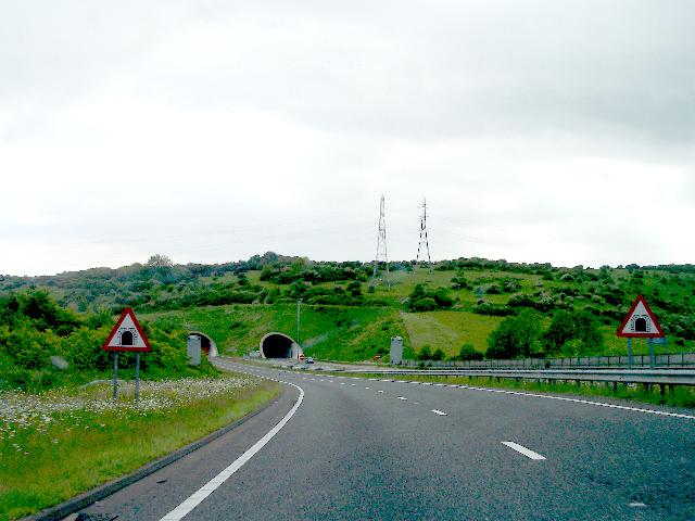
Approaching the Tunnels under Southwick Hill - geograph.org.uk - 179561.jpg - GeographBot
Disused Factory, Hampden Park - geograph.org.uk - 179003.jpg - GeographBot

Remains of a Cross, near Firle - geograph.org.uk - 177448.jpg - GeographBot

Under Southwick Hill (Westbound) - geograph.org.uk - 179566.jpg - GeographBot
Under Southwick Hill - geograph.org.uk - 179558.jpg - GeographBot

Heathland and woodland - geograph.org.uk - 182677.jpg - GeographBot

Students on the beach, below Fairlight Head. - geograph.org.uk - 190078.jpg - GeographBot

Sea Defences at Seaford - geograph.org.uk - 223565.jpg - GeographBot

Drainage works near Wisketts wood - geograph.org.uk - 251136.jpg - GeographBot

Entering Kent - geograph.org.uk - 293685.jpg - GeographBot

Derelict Depot - geograph.org.uk - 323319.jpg - GeographBot

Inside the Derelict Depot. - geograph.org.uk - 323325.jpg - GeographBot

Moat, Moat Wood - geograph.org.uk - 323282.jpg - GeographBot

View from Wick Wood - geograph.org.uk - 326183.jpg - GeographBot

Culvert under Track, Jews Wood - geograph.org.uk - 339342.jpg - Rotatebot

Tenacre Farm Nursery - geograph.org.uk - 333058.jpg - GeographBot

View west of Newick Lane - geograph.org.uk - 333123.jpg - GeographBot

Wych Cross Garden Centre - geograph.org.uk - 335006.jpg - GeographBot

Long Man of Wilmington - geograph.org.uk - 349539.jpg - GeographBot

Picnic Site, Footland Wood - geograph.org.uk - 340137.jpg - GeographBot

Hay meadow near Ashburnham Ford - geograph.org.uk - 358675.jpg - GeographBot

Dew pond on Sweet Hill - geograph.org.uk - 388626.jpg - GeographBot

Hesmond Stud - geograph.org.uk - 383710.jpg - GeographBot

View south from Udiam Lane - geograph.org.uk - 386329.jpg - GeographBot

Orchard windbreak hedge - geograph.org.uk - 392168.jpg - GeographBot

Groynes on Cliff End beach - geograph.org.uk - 437492.jpg - GeographBot

Toot Rock look-out - geograph.org.uk - 437549.jpg - GeographBot

W Keeley and Sons, Timber Merchants and Fencing - geograph.org.uk - 453692.jpg - GeographBot

Young apple orchard - geograph.org.uk - 456751.jpg - GeographBot

Dog Training Equipment - geograph.org.uk - 460757.jpg - GeographBot

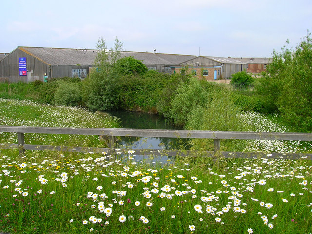
Meadows by the Huglett's Stream - geograph.org.uk - 461072.jpg - GeographBot

Welcoming Committee, Entrance to Frankwell Farm - geograph.org.uk - 460904.jpg - GeographBot

Winkle - geograph.org.uk - 462492.jpg - GeographBot

Bagged up silage - geograph.org.uk - 484023.jpg - GeographBot

The Weald - geograph.org.uk - 505343.jpg - GeographBot

Feeding Time at Primrose Farm - geograph.org.uk - 614516.jpg - GeographBot

Limekiln Bottom - geograph.org.uk - 620294.jpg - GeographBot
Pill Boxes, Cliff End - geograph.org.uk - 620393.jpg - GeographBot

Rough Bottom - geograph.org.uk - 620270.jpg - GeographBot

Rough Bottom - geograph.org.uk - 620283.jpg - GeographBot

Short Bottom - geograph.org.uk - 620299.jpg - GeographBot

Short Bottom - geograph.org.uk - 620306.jpg - GeographBot

Troop B 4 Ever - geograph.org.uk - 620317.jpg - GeographBot

Field Boundary - geograph.org.uk - 642888.jpg - GeographBot

Paddock adjacent to Kidd's Hill - geograph.org.uk - 697695.jpg - GeographBot

At the Foot of the Marshes - geograph.org.uk - 701312.jpg - GeographBot

Hooe Level - geograph.org.uk - 701307.jpg - GeographBot

Embankment, Clff End - geograph.org.uk - 771788.jpg - GeographBot

Electric fence equipment - geograph.org.uk - 807354.jpg - GeographBot

Bridleway to Lunce's Common - geograph.org.uk - 843879.jpg - GeographBot

Footpath into Lullington Heath, East Sussex - geograph.org.uk - 847183.jpg - GeographBot

More House Farm - geograph.org.uk - 843866.jpg - GeographBot

East Sussex border post - geograph.org.uk - 1056483.jpg - GeographBot

The border stream - geograph.org.uk - 1056490.jpg - GeographBot

Bridge over the River Grom - geograph.org.uk - 1104078.jpg - GeographBot

Ash Farm - geograph.org.uk - 1133775.jpg - GeographBot
Beehives near Littledown Cottages - geograph.org.uk - 1154179.jpg - GeographBot

Bridge over the River Grom - geograph.org.uk - 1151615.jpg - GeographBot

Stile and a large Oak tree by the River Grom - geograph.org.uk - 1151954.jpg - GeographBot

Rockfalls near Portobello - geograph.org.uk - 1204981.jpg - GeographBot

Road junction with B2188 - geograph.org.uk - 1242766.jpg - GeographBot

Browndown Wood - geograph.org.uk - 1251661.jpg - GeographBot

Fallen tree, Beckington Wood - geograph.org.uk - 1251720.jpg - GeographBot

Footpath leading to Beckington Wood - geograph.org.uk - 1251709.jpg - GeographBot

Footpath signpost south of Dunstan's Wood - geograph.org.uk - 1251692.jpg - GeographBot

Footpath through Beckington Wood - geograph.org.uk - 1251722.jpg - GeographBot

Fountain Wood - geograph.org.uk - 1251685.jpg - GeographBot

Hay bales by the footpath near Beckington Wood - geograph.org.uk - 1251705.jpg - GeographBot
Looking South to Furnace Wood - geograph.org.uk - 1251681.jpg - GeographBot

Pond on the edge of Browndown Wood - geograph.org.uk - 1251658.jpg - GeographBot

Stile and Gate on the footpath SE of Old Heathfield - geograph.org.uk - 1251652.jpg - GeographBot

Stile entering Beckington Wood - geograph.org.uk - 1251715.jpg - GeographBot

Stile on the edge of Browndown Wood - geograph.org.uk - 1251667.jpg - GeographBot

Stile on the footpath leading to Beckington Wood - geograph.org.uk - 1251698.jpg - GeographBot

The edge of St Dunstan's Wood - geograph.org.uk - 1251674.jpg - GeographBot

Welcome to East Sussex, B2026 - geograph.org.uk - 1375314.jpg - GeographBot

Beehives NW of Strood Farm - geograph.org.uk - 1388756.jpg - GeographBot

Field Systems south of the Chattri - geograph.org.uk - 1421559.jpg - GeographBot

Garden Centre Car Park - geograph.org.uk - 1425489.jpg - GeographBot

Chick Hill - Steep Hill 25^ - geograph.org.uk - 1430874.jpg - GeographBot

Common Lane - geograph.org.uk - 1446169.jpg - GeographBot

Elphicks Farm - geograph.org.uk - 1446199.jpg - GeographBot

Janes Lane - geograph.org.uk - 1446412.jpg - GeographBot

This Is My Best Side - geograph.org.uk - 1449378.jpg - GeographBot

Common Lane - geograph.org.uk - 1450751.jpg - GeographBot

New Road - geograph.org.uk - 1455252.jpg - GeographBot

New Road - geograph.org.uk - 1455284.jpg - GeographBot

Lewes Road - geograph.org.uk - 1474715.jpg - GeographBot

The Old Post Office - geograph.org.uk - 1508661.jpg - GeographBot

Ditchling Road - geograph.org.uk - 1521064.jpg - GeographBot

Lewes Road - geograph.org.uk - 1521053.jpg - GeographBot

Denshire Field - geograph.org.uk - 1543739.jpg - GeographBot

Unharvested Corn Field - geograph.org.uk - 1554255.jpg - GeographBot

Field with pigs and goats, Spring Barn Farm, Kingston, East Sussex - geograph.org.uk - 1577911.jpg - GeographBot

Lower Hook Wood - geograph.org.uk - 1573430.jpg - GeographBot

Polytunnels and soft fruit orchard, Tablehurst Farm - geograph.org.uk - 1691146.jpg - GeographBot

Bridges near High Rock Lane - geograph.org.uk - 1736814.jpg - GeographBot

Sussex wood.jpg - Wilfridselsey

Bristol LHS Bus at Staplecross Shrub Centre - geograph.org.uk - 2339012.jpg - File Upload Bot (Magnus Manske)

Staplecross Nursery - geograph.org.uk - 2339024.jpg - File Upload Bot (Magnus Manske)

Cooksbridge Level Crossing (open).jpg - Nathan A RF

Old Massey Ferguson Tractor, Heaven Farm, East Sussex (24060146656).jpg - OSX II

View from caravan at Heaven Farm, East Sussex (24060257806).jpg - OSX II

View of Borde Hill Place 3.jpg - Margaret Anne Clarke

Ladycross 1959.jpg - Robinbrockway

Haywards Heath banner Borde Hill Place.jpg - AlasdairW

Last Days (85567695).jpeg - Rodrigo.Argenton

The Bathing Pool , St.Leonards on sea. c1987 (14450548096).jpg - Jpbowen

The Band Stand in Warrior Square Gardens, St.Leonards on sea. 1980s. (10122907004).jpg - Jpbowen

The 'Padlock Sculpture' at Warrior Square, St.Leonards on sea. (8063216770).jpg - Jpbowen

2013-09-18 Seven Sisters cliffs by Studiofootnotes.jpg - Studiofootnotes

2013-09-18 Cow Gap by Studiofootnotes.jpg - Studiofootnotes

East Sussex Fire Brigade Lewes Chief Franz-Josef Sehr 1987-08-01.jpg - Nassauer27

East Sussex County election results 1985.svg - Into oblivion