Wikimedi'Òc
Modes d'emploi

Cet album fait partie des albums
Cet album photos contient les sous-albums suivants :


Backbone as proposed in 1956.JPG - Riggwelter
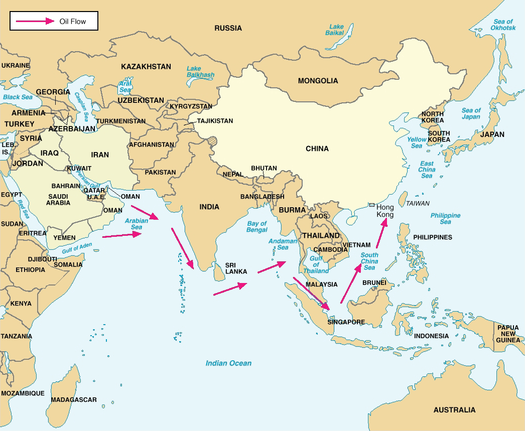
China’s Critical Sea Lines of Communication.png - Ras67

Reception UMTS of KPN Netherlands.PNG - Dryke

OIRT member states.png - DelygaridPlajgadnill

CMEpage3 no border.JPG - Moravecr
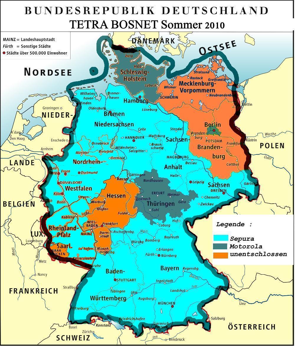
Bosnet-2009.jpg - Gonzosft

European Broadcasting Union members.png - File Upload Bot (Magnus Manske)

Cobertura QuetzSat1.png - Kiel.alvarado

Europe mobile phone penetration map v3.png - Рагин1987

Arab Satellite Communications Organization.png - File Upload Bot (Magnus Manske)

Telecom Italia company in the world.jpg - Zandrek

Viatel-network-map.jpg - Louisewells

Wikipedia Goodspeed Map.svg - Dgtrittenwein

LgTelephoneMap.jpg - Chumwa

Image from page 636 of "The Bell System technical journal" (1922) (14569539429).jpg - Rauschenderbach

Bell telephone magazine (1922) (14753237731).jpg - Fæ

Bell telephone magazine (1922) (14756405675).jpg - Fæ

Bell telephone magazine (1922) (14569747628).jpg - Fæ

Bell telephone magazine (1922) (14570027617).jpg - Fæ

Bell telephone magazine (1922) (14569843138).jpg - Fæ

Bell telephone magazine (1922) (14756067842).jpg - Fæ

Bell telephone magazine (1922) (14776265123).jpg - Fæ

Bell telephone magazine (1922) (14776263173).jpg - SteinsplitterBot

Amos-6-Ka-band-coverage.svg - Cvdr

Bell telephone magazine (1922) (14569702640).jpg - SteinsplitterBot

Western Sahara 1876.png - Koavf
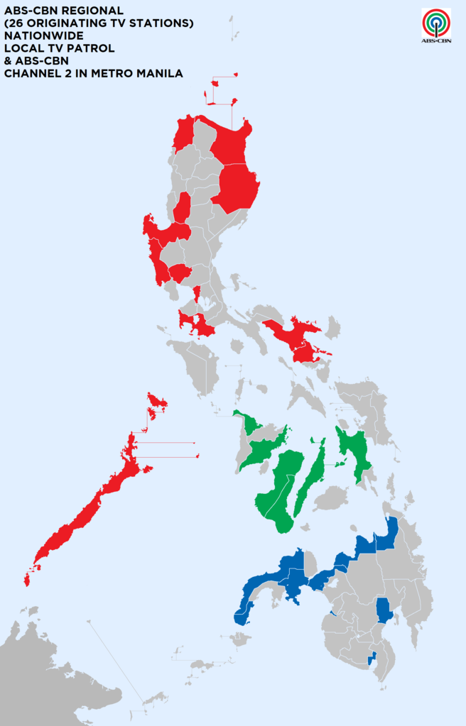
ABS-CBN Channel 2 in Metro Manila (ABS-CBN Regional 26 Orginating TV Station).png - Nissan1950

Network map ESA286082.png - Fæ

Broadcasting map, 3-26-38 LCCN2016873342.jpg - Fæ

Broadband Penetration by District Moldova.jpg - PYX-340
Map of the island of Porto Rico showing the lines of signal communication, telegraph, telephone, and heliograph, operated by the Signals Corps, U.S. Army, with military posts. LOC 98687139.tif - Fæ

Map of the island of Porto Rico showing the lines of signal communication, telegraph, telephone, and heliograph, operated by the Signals Corps, U.S. Army, with military posts. LOC 98687139.jpg - Fæ

Companhia Telephonica de Socorros Rodoviarios Planta Schematica das Estradas de Rodagem do Estado São Paulo - 1, Acervo do Museu Paulista da USP.jpg - GiFontenelle

BTCL Optical Fiber Network 2014.jpg - TurboX

USA Holyoke location map municipal fiber network.svg - Simtropolitan
Layout diagram for transcontinental transmission of Harding November 11, 1921 Armistice Day speech.gif - Thomas H. White

Map of the Balkan States showing communications.jpg - Balkanique

29525 - North Vietnam Main Wireline Circuits - NARA - 74797501.jpg - US National Archives bot

The Circulation of Letters to and from (BM J,11.4).jpg - Copyfraud

The Circulation of Letters to and from (BM J,11.5).jpg - Copyfraud

The Circulation of Letters to and from (BM J,11.2).jpg - Copyfraud

BAMS Zones of communication.png - Scope creep

The Harmsworth atlas and Gazetter 1908 (135848414).jpg - Polona Upload

The Harmsworth atlas and Gazetter 1908 (135852260).jpg - Polona Upload

Télécommunications - Îles Marshall.svg - Bastenbas

Carte des voies de communication de l'Afrique Equatoriale Française, 1-3.000.000 - (Signé -) A. Meunier - btv1b532133526.jpg - Gzen92Bot

Map of China, shewing railways, telegraphs and treaty ports, 1-5.000.000. Drawn and printed at the Ordnance Survey office - btv1b530637211.jpg - Gzen92Bot

Carte des relations du comptoir international de publicité - Amérique du sud, Antilles, Mexique, Portugal - btv1b8468474w.jpg - Gzen92Bot

Madagascar et dépendances. Carte des communications électriques et radioélectriques. 1er juillet 1929 - btv1b530668380.jpg - Gzen92Bot

Map Evolution of communication network 1992 - Touring Club Italiano CART-TEM-088.jpg - Ilaria Parma (TCI)

Map Communication I 1992 - Touring Club Italiano CART-TEM-089.jpg - Ilaria Parma (TCI)

Map Communication II 1992 - Touring Club Italiano CART-TEM-090.jpg - Ilaria Parma (TCI)

Union of Soviet Socialist Republics (USSR) - Caucasus Area Telecommunications - DPLA - 05f05db24ceedda1998cf488e947abe9.jpg - DPLA bot

Military Map of the United States, Showing the Telegraphical Lines in U.S. and Territories - DPLA - fb7eac46cffce5103a671a3a5059e186 (page 1).jpg - DPLA bot

Military Map of the United States, Showing the Telegraphical Lines in U.S. and Territories - DPLA - fb7eac46cffce5103a671a3a5059e186 (page 2).jpg - DPLA bot

Argentina Radio Facilities - DPLA - 1d4f87e35b9c067a9c0f7dbf0df9cad5.jpg - TheImaCow

Union of Soviet Socialist Republics (USSR) (Including Latvia, Lithuania, Estonia, Tannu Tuva, and island possessions) Radio Stations Associated with Basic Telephone and Telegraph Ne - DPLA - 141f902fedabe5ddff8aa373023ac0df.jpg - DPLA bot

Arabian Peninsula Telecommunications - DPLA - 6a41793c3aba4d2b016a21d7e260092a.jpg - TheImaCow

Teletalk Network Coverage Map - 2G - Amader Phone.png - BGDcellular

Rete stradale e ferroviaria Italia 1940-1985 - Map Communication I 1992 - Touring Club Italiano CART-TEM-089.jpg - Marco Chemello (WMIT)
Telegrafo ecuador.png - Sebasdreyes

The Harmsworth atlas and Gazetter 1908 Postal world map.jpg - Enyavar

Funken- und Kabel-Telegraphie im Mittelländischen Meer (ca.1912).jpg - Enyavar

International Radio and Television Organisation member states.svg - Colohisto