Wikimedi'Òc
Modes d'emploi

Cet album fait partie des albums
Cet album photos contient les sous-albums suivants :


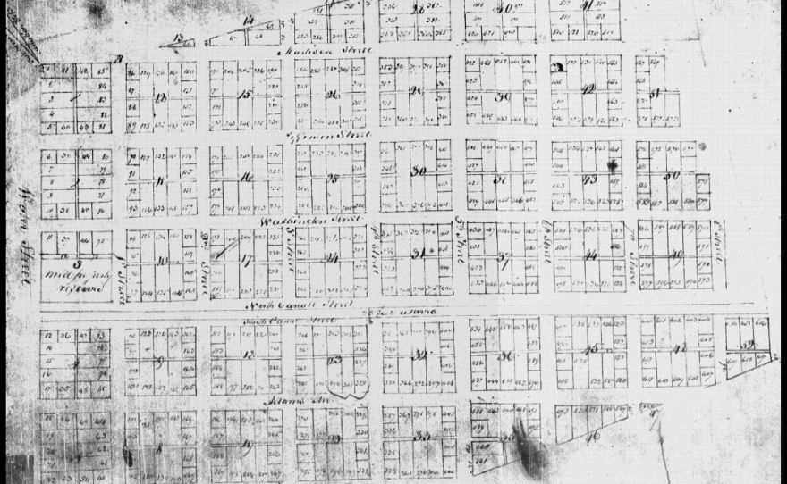
Ohio River Base plat, page 0185.jpg - Richard Arthur Norton (1958- )

Ugland1-j.jpg - Friman
Sith and I plan.jpg - FLLL
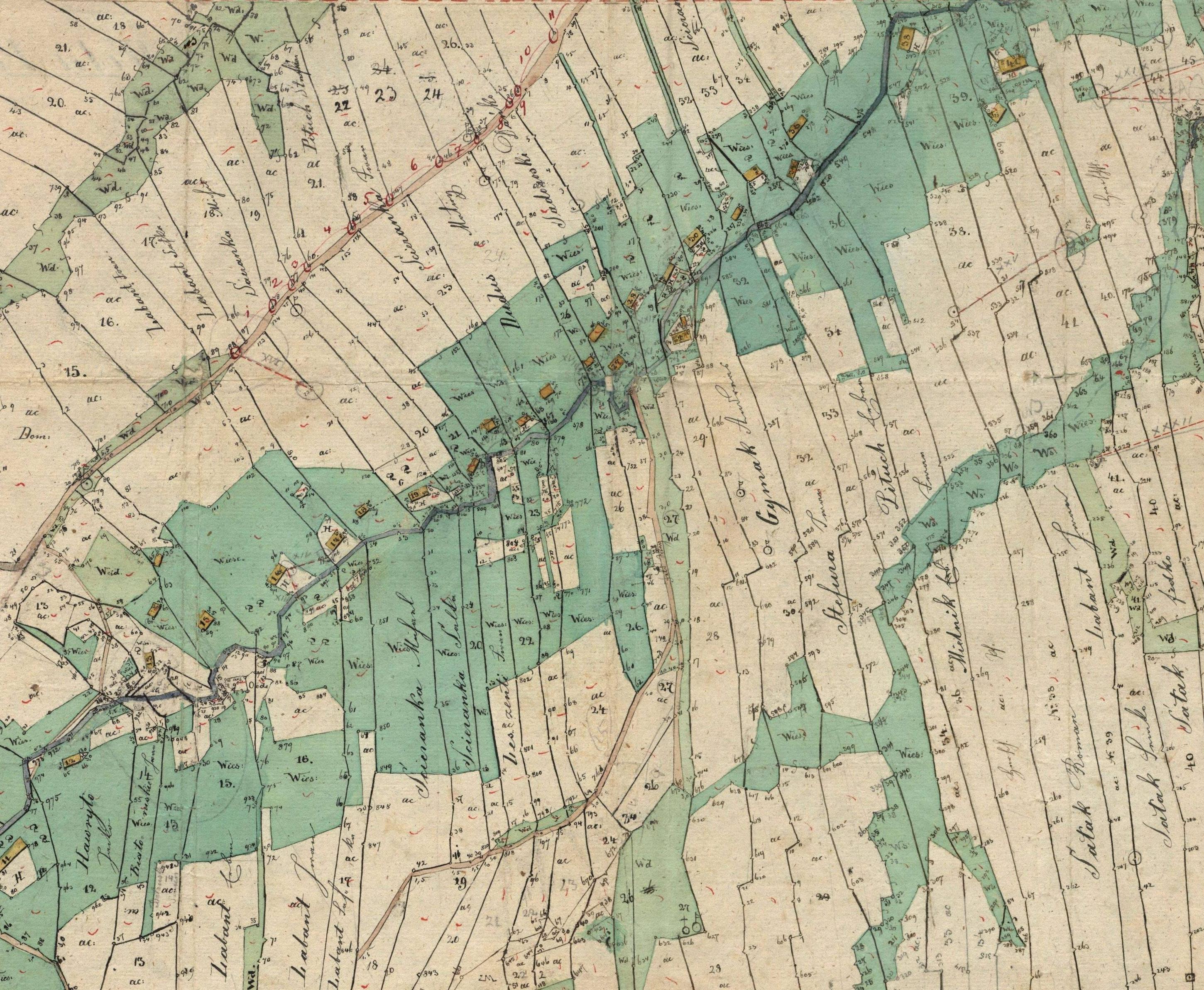
Mapa katastralna wsi Wola Piotrowa 1852.JPG - Herstass
Catastro Machado.png - Poiche
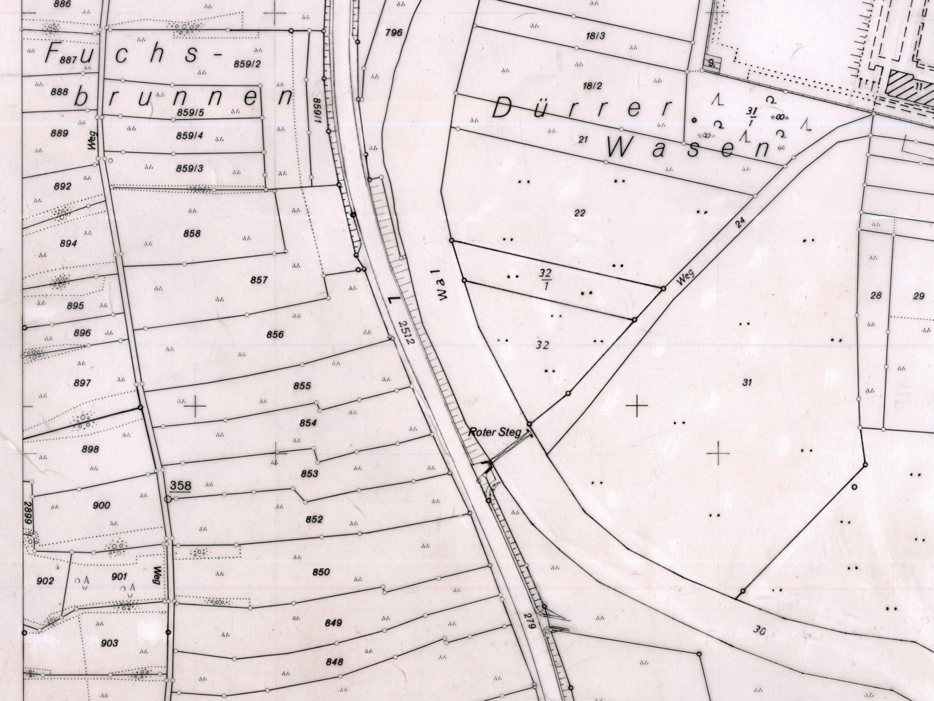
Flurkarte.jpg - Schorle

Foto ahpcr.jpg - Rotatebot

Foto ahpcr2.jpg - Cmasgz

Soderakra 1800.jpg - Pierre p77

Stadtplan Tübingen 1819.png - Studmult

Nagorzany1852R.jpg - Silar

StBart quartiers 1801.jpg - Hic et nunc

Nadolany (Nowoatniec) - mapa katastralna (1852).jpg - File Upload Bot (Magnus Manske)

Bukowsko - mapa katastralna (1906).jpg - File Upload Bot (Magnus Manske)

Dudynce - mapa 1852.jpg - File Upload Bot (Magnus Manske)

Hietamäki 1687 isojakokartta.jpg - Cropbot

Hietamäki 1687 isojakokartta crop.jpg - Albval

Pielnia 1852.jpg - Obersachse

Altshausen Hartweiher Kataster.jpg - Alfred Adler

Urhandriß.jpg - File Upload Bot (Magnus Manske)

Map of Harris County - Northeast One-fourth.jpg - Tangerinehistry

Netherlands, Warmond, Lakerpolder, Tuinder- of Kogjespolder.jpg - Loranchet
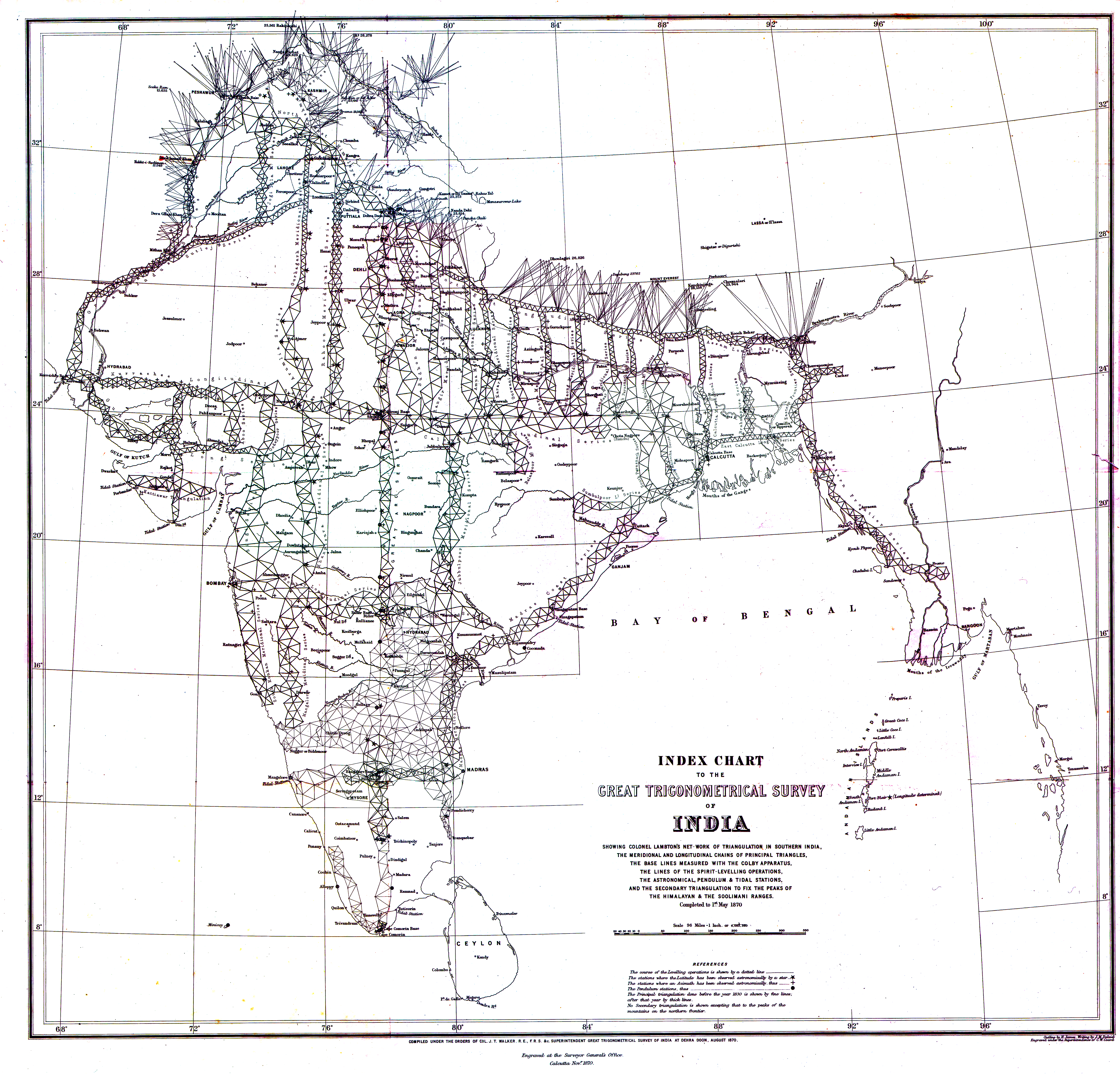
1870 Index Chart to GTS India-1.jpg - Shyamal
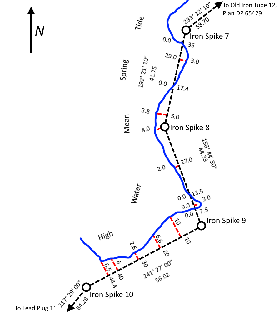
Traversing and Offsetting DP 79152.png - TBP25

Planimetric.jpg - Kgis2641

Flurgrenzen.PNG - Ratzer

Ott Frères, SUUM CUIQUE.jpg - Edelseider

Molière (Pailharès) plan cadastral 1837 (Archives départementales Ardèche).jpg - Peb45

Sokhumi City Municipality Cadastral Map, AR of Abkhazia, Georgia.png - Abkhazian1

1681. gads.jpg - Valsts zemes dienests

1937. gads.jpg - Valsts zemes dienests

Mauritius 1880 map by Descubes.jpg - Ratzer

SurveyCottonSpindleSpike1.jpg - Etan J. Tal
Plan of the village in old Cambridge,1833.tif - Mcmcg11
Map of Fresh Pond (Cambridge, Mass.), 1841.tif - Mcmcg11
Map of Concord, Mass., 1852.tif - Mcmcg11

Map of the Parish of Catahoula, Louisiana LOC 2012592312.jpg - Startbosshogg

Republic of Korea fake Cadastral map.jpg - Trainholic
Plat of the Shoquel Rancho.pdf - Keavon
Plat of the Shoquel Augmentation Rancho.pdf - Keavon
Plat of the Aptos Rancho.pdf - Keavon

Headquarters2.png - WritteninStone4

Mowry1.png - WritteninStone4

Mowry2.0.png - WritteninStone4

Mowry3-0.png - WritteninStone4

Pauline H. Rosenberg House 3.png - WritteninStone4

HerronHill6.jpg - WritteninStone4
1837 plat map of Brooklyn, Illinois.jpg - HLHJ

Plat Map for Township 19 and Range 10 - DPLA - ee96fc3eab0cb4a747847f29939ae6cf.jpg - DPLA bot

Plat Map for Township 11 and Range 08 - DPLA - d6183ec098e1238d825e6e2699895351.jpg - DPLA bot

Plat of a Survey For Richard Barnes - DPLA - a5bcece0a6057bbebf6636ab22b06a03.jpg - DPLA bot

Plat Map for Township 19 and Range 10 with Landmarks - DPLA - ac8373db21d809e29848c7c622633209.jpg - DPLA bot

Podcast with Dr. Alvita Puspa Handayani.jpg - Dasaptaerwin

Stadtplan Tübingen von C. Kohler (1819).jpg - Mewa767

Map of Lindhurst Hundred.jpg - F.newnham

Map of New River Hundred.jpg - F.newnham

Map of Wendon, Wendonside and of Greenvale Survey Districts.jpg - F.newnham

Map of Wakaia and Part of Wart Hill Survey Districts.jpg - F.newnham

Toetoes Survey District.jpg - F.newnham

Map of Wyndham Survey District, also Part of the Districts of Mokoreta and Slopedown.jpg - F.newnham

Mabel Hundred.jpg - F.newnham

Map of Longwood District.jpg - F.newnham

Map of Forest Hill Hundred.jpg - F.newnham

SD 55 - Waimumu Hundred and Part of Hokonui District.jpg - F.newnham

SD 70 - Map of Campbelltown Hundred.jpg - F.newnham

Lothian and Mataura Hundreds.jpg - F.newnham

Centre Hill Survey District.jpg - F.newnham

Crookston Survey District.jpg - F.newnham

Plan of the Edendale Settlement - Lindhurst, Lothian, Mataura and Oteramika Hundreds.jpg - F.newnham

SD 66 - Map of Invercargill Hundred and Part of New River Hundred.jpg - F.newnham

Tuturau Survey District.jpg - F.newnham

Map of Taringatura Survey District.jpg - F.newnham

Map of Invercargill Hundred and Part of New River Hundred.jpg - F.newnham

Lawrence-Roxburgh Railway - Proclamation Plan Defining Centre Line.jpg - F.newnham

Otago (OT) 143 - Kuriwao Survey District.jpg - F.newnham

Southland (SD) 44 - Wairio Survey District.jpg - F.newnham

OT 136 - Pomahaka Survey District.jpg - F.newnham

Greenvale Survey District.jpg - F.newnham

Waikaka Survey District.jpg - F.newnham

OT 159 - Woodland Survey District.jpg - F.newnham

OT 135 - Waipahi Survey District.jpg - F.newnham

SD 36 - Map of Hokonui Survey District.jpg - F.newnham

Plano Catastral Córdoba 1890.jpg - GM83

Reviewing cadastre.jpg - Javiersanp

KM Gries Bl 10 Quirein Talfer Fagen.jpg - Bartleby08

Biała (Bielsko-Biała) mapa katastralna 1913, aktualizacja po 1920.jpg - Gaj777

Rancho Aguaje de la Centinela BLM survey map 1872.jpg - Jengod

Fisher's Station, Wyoming Township, 1876.png - WMrapids
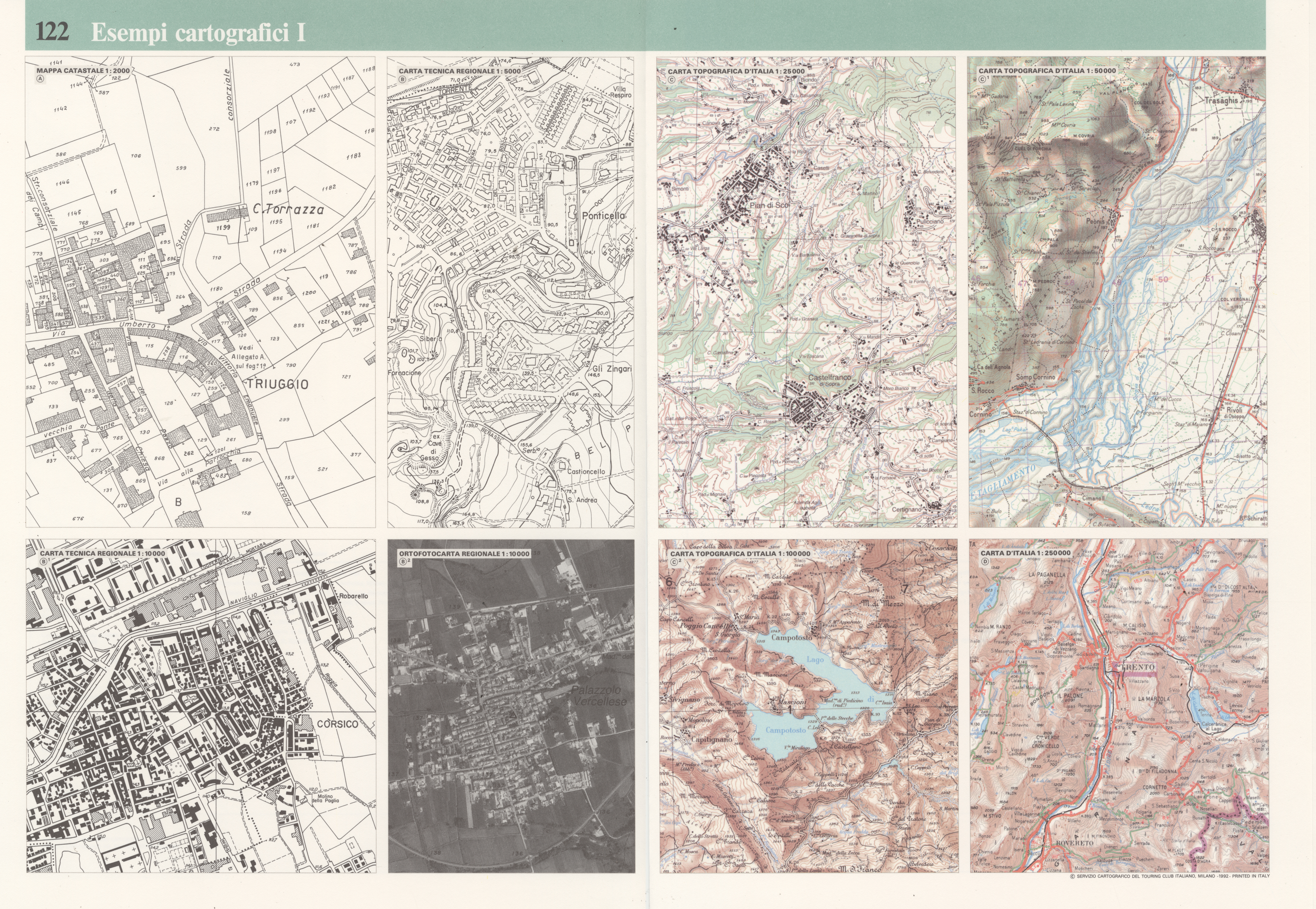
Map Cartographic examples I 1992 - Touring Club Italiano CART-TEM-122.jpg - Ilaria Parma (TCI)

Trayectoria de Gabriela Mistral, Años 1922-1958.jpg - Rjcastillo

Sheet 3 from Salt Lake County Recorder Plat Maps, Bingham Plat A, 1962-1963, Reel 09137, Record Series RC-052.jpg - Bigbear213

Plat E, Bingham Townsite Map, 1900 from the Salt Lake County Recorder's Bingham Canyon Maps.png - Bigbear213
Plat Map of the proposed Bingham Canyon twon as part of the incorporation records, 1904.tif - Bigbear213

Eden, Fayette County, Iowa.png - Firsfron

Melbourne and its suburbs, shewing (sic) a district embracing seventeen parishes, 1858.jpg - Sgroey

Plan cadastral de Nice en 1812 - Section X - Saint-Philippe.jpg - Theop06

Standard Atlas, Blue Earth County, Minnesota - DPLA - 05b5a43b2b3d3d0bcb7e286688424403 (page 29).jpg - DPLA bot

Standard Atlas, Blue Earth County, Minnesota - DPLA - 05b5a43b2b3d3d0bcb7e286688424403 (page 35).jpg - DPLA bot

Standard Atlas, Blue Earth County, Minnesota - DPLA - 05b5a43b2b3d3d0bcb7e286688424403 (page 38).jpg - DPLA bot

Standard Atlas, Blue Earth County, Minnesota - DPLA - 05b5a43b2b3d3d0bcb7e286688424403 (page 40).jpg - DPLA bot

Standard Atlas, Blue Earth County, Minnesota - DPLA - 05b5a43b2b3d3d0bcb7e286688424403 (page 42).jpg - DPLA bot

Standard Atlas, Blue Earth County, Minnesota - DPLA - 05b5a43b2b3d3d0bcb7e286688424403 (page 44).jpg - DPLA bot

Standard Atlas, Blue Earth County, Minnesota - DPLA - 05b5a43b2b3d3d0bcb7e286688424403 (page 46).jpg - DPLA bot

Standard Atlas, Blue Earth County, Minnesota - DPLA - 05b5a43b2b3d3d0bcb7e286688424403 (page 47).jpg - DPLA bot

Standard Atlas, Blue Earth County, Minnesota - DPLA - 05b5a43b2b3d3d0bcb7e286688424403 (page 48).jpg - DPLA bot

Standard Atlas, Blue Earth County, Minnesota - DPLA - 05b5a43b2b3d3d0bcb7e286688424403 (page 49).jpg - DPLA bot

Plat Map, Mendon, Chariton Co. Missouri, 1876.jpg - Binx1966

Plat Map, Mendon, Missouri, 1915.jpg - Binx1966