Wikimedi'Òc
Modes d'emploi

Cet album fait partie des albums
Cet album photos contient les sous-albums suivants :


Burgh Castle Roman Fort - geograph.org.uk - 7530485.jpg - GeographBot

St. Peter ^ St. Paul's Church, Burgh Castle - geograph.org.uk - 7530505.jpg - GeographBot

Footpath along the River Yare towards Breydon Water - geograph.org.uk - 7618544.jpg - GeographBot

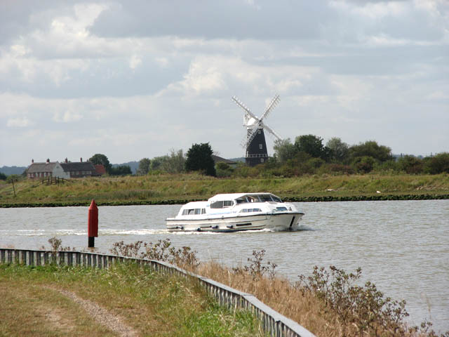
Burgh Flats from the Angles Way - geograph.org.uk - 7618548.jpg - GeographBot

Church of St. Peter and St. Paul, Burgh Castle - geograph.org.uk - 7650113.jpg - GeographBot

Font in Church of St. Peter and St. Paul, Burgh Castle - geograph.org.uk - 7650114.jpg - GeographBot

Burgh Castle Roman Saxon Shore Fort - geograph.org.uk - 7650117.jpg - GeographBot

Burgh Castle Roman Saxon Shore Fort - geograph.org.uk - 7650119.jpg - GeographBot

Burgh Castle Roman Saxon Shore Fort - geograph.org.uk - 7650121.jpg - GeographBot

Burgh Castle Roman Saxon Shore Fort - geograph.org.uk - 7650122.jpg - GeographBot

Holiday homes near Burgh Castle - geograph.org.uk - 62017.jpg - GeographBot

Junction - Rivers Yare and Waveney - geograph.org.uk - 62014.jpg - GeographBot

Lockgate Drainage Mill - geograph.org.uk - 62011.jpg - GeographBot

River Waveney - geograph.org.uk - 62018.jpg - GeographBot

River Waveney and Caldecott Drainage Mill - geograph.org.uk - 112385.jpg - GeographBot

River Yare looking towards Wickhampton - geograph.org.uk - 190676.jpg - GeographBot

Burgh Castle marshes - geograph.org.uk - 287238.jpg - GeographBot

Footbridge by River Waveney - geograph.org.uk - 314905.jpg - GeographBot

Butt Lane - Burgh Castle - geograph.org.uk - 450427.jpg - GeographBot

Butt Lane Burgh Castle - geograph.org.uk - 451979.jpg - GeographBot

Mill Farm Cottage nr. Burgh Castle - geograph.org.uk - 451973.jpg - GeographBot

Welcome Pit - Hardcore Recycling Centre - geograph.org.uk - 450004.jpg - GeographBot

High days and holidays - geograph.org.uk - 540726.jpg - GeographBot

Railway track heading towards Lockgate Drainage Mill - geograph.org.uk - 652622.jpg - GeographBot

View across the River Waveney - geograph.org.uk - 693531.jpg - GeographBot

View east along Church Road - geograph.org.uk - 693584.jpg - GeographBot

Berney Marshes - geograph.org.uk - 807356.jpg - GeographBot

Junction of the Yare and the Waveney - geograph.org.uk - 807673.jpg - GeographBot

Landing stage, Berney Arms - geograph.org.uk - 807352.jpg - GeographBot

Marshland on the Yare - geograph.org.uk - 808663.jpg - GeographBot

River Yare from River Waveney - geograph.org.uk - 807645.jpg - GeographBot

Sea wall, Berney Marshes - geograph.org.uk - 807619.jpg - GeographBot

Waders, mouth of the Waveney - geograph.org.uk - 807666.jpg - GeographBot

Wind pump, Fisher's Marshes - geograph.org.uk - 807481.jpg - GeographBot

Belton Marshes - geograph.org.uk - 813022.jpg - GeographBot

Marshland, Burgh Castle - geograph.org.uk - 813167.jpg - GeographBot

Colourful Pub - geograph.org.uk - 1068524.jpg - GeographBot

Colourful Pub - geograph.org.uk - 1068527.jpg - GeographBot

Approaching Breydon Water - geograph.org.uk - 1484273.jpg - GeographBot
Boat passing navigation channel marker - geograph.org.uk - 1484328.jpg - GeographBot

Boat travelling downstream on the River Waveney - geograph.org.uk - 1484241.jpg - GeographBot

Camouflage colours - geograph.org.uk - 1484195.jpg - GeographBot

Church Farm Swim - geograph.org.uk - 1484232.jpg - GeographBot

Entrance to Church Farm Swim - geograph.org.uk - 1484218.jpg - GeographBot

Going fishing - geograph.org.uk - 1484228.jpg - GeographBot

Navigation channel markers on the Waveney - geograph.org.uk - 1484244.jpg - GeographBot

Pastures in Churchfarm Marshes - geograph.org.uk - 1484271.jpg - GeographBot

The Lodge - geograph.org.uk - 1484204.jpg - GeographBot

The peacock house - geograph.org.uk - 1484172.jpg - GeographBot

This way to Church Farm Swim - geograph.org.uk - 1484216.jpg - GeographBot
Transformer in the woods - geograph.org.uk - 1484212.jpg - GeographBot

Two rivers meet - geograph.org.uk - 1484235.jpg - GeographBot
View across Burgh Castle Marshes - geograph.org.uk - 1484278.jpg - GeographBot

View across Burgh Castle Marshes - geograph.org.uk - 1484318.jpg - GeographBot

View across the Churchfarm Marshes - geograph.org.uk - 1484245.jpg - GeographBot

View across the Waveney - geograph.org.uk - 1484275.jpg - GeographBot

Caravans in Yare Valley caravan park - geograph.org.uk - 1577322.jpg - GeographBot

Church Lane in Burgh Castle - geograph.org.uk - 1577344.jpg - GeographBot

Farm sheds west of the Roman fort of Gariannonum - geograph.org.uk - 1577467.jpg - GeographBot

Gate into a pasture - geograph.org.uk - 1577359.jpg - GeographBot

House on the grid line - geograph.org.uk - 1577337.jpg - GeographBot

Junction of Butt Lane and Church Lane - geograph.org.uk - 1577330.jpg - GeographBot

Kissing gate on footpath through pasture - geograph.org.uk - 1577464.jpg - GeographBot

Post Office and shop in Butt Lane - geograph.org.uk - 1577317.jpg - GeographBot

View across Butt Lane - geograph.org.uk - 1577329.jpg - GeographBot

View west along Church Lane - geograph.org.uk - 1577338.jpg - GeographBot

A row of ivy-clad trees - geograph.org.uk - 1632070.jpg - GeographBot

Burgh Castle Beach - geograph.org.uk - 1632290.jpg - GeographBot

Butt Lane past entrance to Kingfisher Holiday Park - geograph.org.uk - 1631823.jpg - GeographBot

Chalets in the Kingfisher Holiday Park - geograph.org.uk - 1632061.jpg - GeographBot

Christmas ornaments in front garden in The Dell - geograph.org.uk - 1632328.jpg - GeographBot

Cottages in Butt Lane, Burgh Castle - geograph.org.uk - 1631798.jpg - GeographBot

Entrance to recycling centre in Butt Lane - geograph.org.uk - 1631817.jpg - GeographBot

Entrance to the Kingfisher Holiday Park in Butt Lane - geograph.org.uk - 1631827.jpg - GeographBot

Footpath along the River Waveney - geograph.org.uk - 1632284.jpg - GeographBot

Holiday chalets in the snow - geograph.org.uk - 1632058.jpg - GeographBot

Icy road past caravan site - geograph.org.uk - 1632324.jpg - GeographBot

Kingfisher Holiday Park viewed from The Dell - geograph.org.uk - 1632334.jpg - GeographBot

Kissing gate into holiday park - geograph.org.uk - 1632083.jpg - GeographBot

Llama in pasture by Welcome Farm - geograph.org.uk - 1631820.jpg - GeographBot

Public footpath traversing Goodchild's boatyard - geograph.org.uk - 1632302.jpg - GeographBot

Road past Goodchild's boatyard - geograph.org.uk - 1632304.jpg - GeographBot

Sluice on the River Waveney - geograph.org.uk - 1632286.jpg - GeographBot

Snowy pasture south of Porters Loke - geograph.org.uk - 1632048.jpg - GeographBot

Static caravan in Kingfisher Holiday Park - geograph.org.uk - 1631799.jpg - GeographBot

Static caravan in Kingfisher Holiday Park - geograph.org.uk - 1631885.jpg - GeographBot

The Dell - geograph.org.uk - 1631803.jpg - GeographBot

The Dell past Yare Valley caravan park - geograph.org.uk - 1632331.jpg - GeographBot

The Golden Fish Restaurant - geograph.org.uk - 1631828.jpg - GeographBot

The Kingfisher Holiday Park west of Butt Lane - geograph.org.uk - 1631825.jpg - GeographBot

The River Waveney on Christmas Eve - geograph.org.uk - 1632287.jpg - GeographBot
Transformer on Burgh Castle Beach - geograph.org.uk - 1632292.jpg - GeographBot
Transformer supplying Willow Cottage - geograph.org.uk - 1632086.jpg - GeographBot

Trees alongside the Kingfisher Holiday Park - geograph.org.uk - 1632081.jpg - GeographBot

View east along Porters Loke - geograph.org.uk - 1632053.jpg - GeographBot

View east along The Dell - geograph.org.uk - 1632330.jpg - GeographBot

View west along The Dell - geograph.org.uk - 1632336.jpg - GeographBot

Welcome Farm in Butt Lane, Burgh Castle - geograph.org.uk - 1631822.jpg - GeographBot

Map of Suffolk OS Map name 002-NW, Ordnance Survey, 1881-1893.jpg - Fæ
Burgh Castle. Cb.jpg - J.C EVEN
Burgh Castle. Cb-2.gif - J.C EVEN

Meadows near Burgh Castle - geograph.org.uk - 1950865.jpg - GeographBot

Burgh Castle Norfolk - geograph.org.uk - 1951449.jpg - GeographBot

The Site of the Motte and Bailey Castle - geograph.org.uk - 1951456.jpg - GeographBot

The Old Eastuary - geograph.org.uk - 1951482.jpg - GeographBot

View from Burgh Castle - geograph.org.uk - 1951502.jpg - GeographBot

Disused Windpump - geograph.org.uk - 1951514.jpg - GeographBot

View from the levelled castle - geograph.org.uk - 1951519.jpg - GeographBot

Inside Burgh Castle - geograph.org.uk - 1951661.jpg - GeographBot

Hooded Crow - geograph.org.uk - 1979669.jpg - GeographBot

Herring Gull - geograph.org.uk - 1980924.jpg - GeographBot

Panorama from Burgh Castle - geograph.org.uk - 1982565.jpg - GeographBot

Immature Black Headed Gull - geograph.org.uk - 1986403.jpg - GeographBot

Burgh Castle aerial (16547970276).jpg - Sentinel user

Busy day at Churchfarm Marshes fishing lakes - geograph.org.uk - 2055617.jpg - GeographBot

Waiting for a catch at Churchfarm Marshes fishing lakes - geograph.org.uk - 2055636.jpg - GeographBot

Confluence of the Rivers Waveney and Yare - geograph.org.uk - 2055665.jpg - GeographBot

Wild mustard growing beside the Angles Way - geograph.org.uk - 2055670.jpg - GeographBot

The Angles Way along the River Waveney - geograph.org.uk - 2055672.jpg - GeographBot

The River Waveney south of Breydon Water - geograph.org.uk - 2055674.jpg - GeographBot

Foraging on the bank of the River Waveney - geograph.org.uk - 2055677.jpg - GeographBot

Big sky over the River Waveney - geograph.org.uk - 2055683.jpg - GeographBot
Boats on the River Waveney south of Breydon Water - geograph.org.uk - 2055685.jpg - GeographBot

Waves on the River Waveney - geograph.org.uk - 2055692.jpg - GeographBot

Boats on Breydon Water - geograph.org.uk - 2055698.jpg - GeographBot

Waves on Breydon Water - geograph.org.uk - 2055701.jpg - GeographBot

Sailing boat, Burgh Flats, River Waveney - geograph.org.uk - 2151043.jpg - GeographBot

View over River Waveney - geograph.org.uk - 2245703.jpg - GeographBot

Slow Speed - geograph.org.uk - 2245718.jpg - GeographBot

Mill Road, Bradwell, Suffolk - geograph.org.uk - 2935400.jpg - GeographBot

Information boards, Burgh Castle - geograph.org.uk - 2935418.jpg - GeographBot

Cherry Tree holiday park, Burgh Castle - geograph.org.uk - 2961509.jpg - GeographBot

Cherry Tree holiday park, Burgh Castle - geograph.org.uk - 2973200.jpg - GeographBot

Cherry Tree holiday park Burgh Castle - geograph.org.uk - 2973204.jpg - GeographBot

Church Road, Burgh Castle - geograph.org.uk - 2973990.jpg - GeographBot

High Road, Burgh Castle - geograph.org.uk - 2974002.jpg - GeographBot

Mill Road, Burgh Castle - geograph.org.uk - 2974007.jpg - GeographBot

Butt Lane, Burgh Castle - geograph.org.uk - 2984272.jpg - GeographBot

Entertainments complex, Cherry Tree holiday park, Burgh Castle - geograph.org.uk - 2984296.jpg - GeographBot

Cherry Tree holiday park, Burgh Castle - geograph.org.uk - 2984300.jpg - GeographBot

Broads Authority barge moored on the River Waveney - geograph.org.uk - 3140779.jpg - GeographBot

Broads Authority barge moored on the River Waveney - geograph.org.uk - 3140782.jpg - GeographBot

Burgh Castle, view across to Berney Arms - geograph.org.uk - 3216658.jpg - GeographBot

Burgh Castle, view across to Berney Arms - geograph.org.uk - 3216660.jpg - GeographBot

Burgh Castle, view across to Berney Arms - geograph.org.uk - 3216661.jpg - GeographBot

Looking towards the Waveney from Burgh Castle - geograph.org.uk - 3505693.jpg - GeographBot

Burgh Flats - geograph.org.uk - 3505695.jpg - GeographBot

Rising tide, Breydon South Flats - geograph.org.uk - 3639456.jpg - GeographBot

Wind-powered drainage pump, Fisher's Marshes - geograph.org.uk - 3639468.jpg - GeographBot

Angles Way at Fisher's Marshes - geograph.org.uk - 3639476.jpg - GeographBot

Reed-filled drain parallel to Breydon Water shore - geograph.org.uk - 3639486.jpg - GeographBot

Fisher's Marshes - geograph.org.uk - 3639492.jpg - GeographBot

Reed-filled drain alongside Angles Way - geograph.org.uk - 3639504.jpg - GeographBot

Harvesting on Fisher's Marshes - geograph.org.uk - 3639516.jpg - GeographBot

Drain on Fisher's Marshes - geograph.org.uk - 3639526.jpg - GeographBot

Angles Way, at the 3 metre spot height - geograph.org.uk - 3639577.jpg - GeographBot

Water-filled drain, south of the pump house - geograph.org.uk - 3639585.jpg - GeographBot

Pump house on the south shore of Breydon Water - geograph.org.uk - 3639591.jpg - GeographBot

Angles Way, alongside Breydon Water - geograph.org.uk - 3639595.jpg - GeographBot

River Yare at Breydon Water - geograph.org.uk - 4281680.jpg - GeographBot

An afternoon's angling at Churchfarm Marshes - geograph.org.uk - 4281814.jpg - GeographBot

The River Yare at Breydon Water - geograph.org.uk - 4281849.jpg - GeographBot

Burgh Castle village sign - geograph.org.uk - 4291518.jpg - GeographBot

Burgh Castle village sign (detail) - geograph.org.uk - 4291519.jpg - GeographBot

Walls of the Roman fort at Burgh Castle - geograph.org.uk - 4577110.jpg - GeographBot

Fishing lakes east of Burgh Flats - geograph.org.uk - 4684130.jpg - GeographBot

Fishing lakes east of Burgh Flats - geograph.org.uk - 4684131.jpg - GeographBot

View towards the confluence of the Rivers Yare and Waveney - geograph.org.uk - 4684137.jpg - GeographBot

Construction work at the confluence of the Rivers Yare and Waveney - geograph.org.uk - 4684139.jpg - GeographBot

Walking the Angles Way - geograph.org.uk - 4684141.jpg - GeographBot

The Angles Way to Great Yarmouth - geograph.org.uk - 4684143.jpg - GeographBot

Common Darter (Sympetrum striolatum) - geograph.org.uk - 4684146.jpg - GeographBot

The Angles Way by Burgh Castle - geograph.org.uk - 4684150.jpg - GeographBot

View across the Burgh Flats - geograph.org.uk - 4684152.jpg - GeographBot

Path along the Burgh Flats - geograph.org.uk - 4684153.jpg - GeographBot

Burgh Flats - geograph.org.uk - 4684156.jpg - GeographBot

To Great Yarmouth on the Angles Way - geograph.org.uk - 4684158.jpg - GeographBot

View across Breydon Water - geograph.org.uk - 4684160.jpg - GeographBot

Churchfarm Marshes - geograph.org.uk - 4684163.jpg - GeographBot

Cattle grazing in Churchfarm Marshes - geograph.org.uk - 4684165.jpg - GeographBot

The Angles Way past Churchfarm Marshes - geograph.org.uk - 4684168.jpg - GeographBot

The Angles Way along the River Waveney - geograph.org.uk - 4684169.jpg - GeographBot

View across the River Waveney - geograph.org.uk - 4684171.jpg - GeographBot

The Angles way skirting Breydon Water - geograph.org.uk - 4684173.jpg - GeographBot

View across Breydon Water - geograph.org.uk - 4684175.jpg - GeographBot

The Angles Way along Breydon Water - geograph.org.uk - 4684176.jpg - GeographBot

The Angles Way to Great Yarmouth - geograph.org.uk - 4684178.jpg - GeographBot

The Burgh Flats on the edge of Breydon Water - geograph.org.uk - 4684180.jpg - GeographBot

The Angles Way along Breydon Water - geograph.org.uk - 4684181.jpg - GeographBot

View across Breydon Water - geograph.org.uk - 4684183.jpg - GeographBot

New housing construction on Butt Lane - geograph.org.uk - 4947653.jpg - GeographBot

Butt Lane - geograph.org.uk - 4947654.jpg - GeographBot

Chinese restaurant on Butt Lane - geograph.org.uk - 4947656.jpg - GeographBot

Entrance to caravan park off Butt Lane - geograph.org.uk - 4947659.jpg - GeographBot

Butt Lane - geograph.org.uk - 4947662.jpg - GeographBot

Burgh Castle Post Office - geograph.org.uk - 4947666.jpg - GeographBot

Grazing and woodland, Burgh Castle - geograph.org.uk - 4947675.jpg - GeographBot

Grazing and hedgerow, Burgh Castle - geograph.org.uk - 4947677.jpg - GeographBot

Grazing, Burgh Castle - geograph.org.uk - 4947681.jpg - GeographBot

Car park for Burgh Castle Roman Site - geograph.org.uk - 4947682.jpg - GeographBot

Grazing off Butt Lane - geograph.org.uk - 4947684.jpg - GeographBot

Houses on Church Road, Burgh Castle - geograph.org.uk - 4947686.jpg - GeographBot

Church Road, Burgh Castle - geograph.org.uk - 4947688.jpg - GeographBot

Farm buildings, The Hollies Farm, Burgh Castle - geograph.org.uk - 4949164.jpg - GeographBot

Farm track off High Road, Burgh Castle - geograph.org.uk - 4949167.jpg - GeographBot

High Road, Burgh Castle - geograph.org.uk - 4949170.jpg - GeographBot

Farmland near Crow's Farm - geograph.org.uk - 4949172.jpg - GeographBot

Mill Road - geograph.org.uk - 4949173.jpg - GeographBot

Gated entrance off Mill Road - geograph.org.uk - 4949174.jpg - GeographBot

Grazing towards Crow's Farm - geograph.org.uk - 4949175.jpg - GeographBot

Market Road - geograph.org.uk - 4949176.jpg - GeographBot

Elizabeth II postbox on Mill Road, Burgh Castle - geograph.org.uk - 4949251.jpg - GeographBot

Close up, Elizabeth II postbox on Mill Road, Burgh Castle - geograph.org.uk - 4949254.jpg - GeographBot

Mill Road, Burgh Castle - geograph.org.uk - 4949255.jpg - GeographBot

Elizabeth II postbox on Butt Lane, Burgh Castle - geograph.org.uk - 4949275.jpg - GeographBot

Close up, Elizabeth II postbox on Butt Lane, Burgh Castle - geograph.org.uk - 4949279.jpg - GeographBot

Butt Lane, Burgh Castle - geograph.org.uk - 4949280.jpg - GeographBot

Across The River Waveney - geograph.org.uk - 5042329.jpg - GeographBot

The Broads From Burgh Castle - geograph.org.uk - 5042334.jpg - GeographBot

Burgh Castle (1) - geograph.org.uk - 5189850.jpg - GeographBot

Burgh Castle (2) - geograph.org.uk - 5189851.jpg - GeographBot

The view from the castle (1) - geograph.org.uk - 5189859.jpg - GeographBot

The view from the castle (2) - geograph.org.uk - 5189862.jpg - GeographBot
The rushes of Glebe Marshes - geograph.org.uk - 5189864.jpg - GeographBot

River Waveney (1) - geograph.org.uk - 5189868.jpg - GeographBot

River Waveney (2) - geograph.org.uk - 5189870.jpg - GeographBot

River Waveney (3) - geograph.org.uk - 5189884.jpg - GeographBot

Angles Way (1) - geograph.org.uk - 5189887.jpg - GeographBot

Angles Way (2) - geograph.org.uk - 5190278.jpg - GeographBot

Three ways to go (1) - geograph.org.uk - 5190288.jpg - GeographBot

Three ways to go (2) - geograph.org.uk - 5190298.jpg - GeographBot
Three ways to go (3) - geograph.org.uk - 5190313.jpg - GeographBot

Path meets road - geograph.org.uk - 5190319.jpg - GeographBot

The Weavers' Way and the River Yare - geograph.org.uk - 5411385.jpg - GeographBot

Field, Burgh Castle - geograph.org.uk - 5424010.jpg - GeographBot

Field, Burgh Castle - geograph.org.uk - 5424115.jpg - GeographBot

Glebe Marshes, Burgh Castle - geograph.org.uk - 5424129.jpg - GeographBot

Rotten wood, Burgh Castle - geograph.org.uk - 5424144.jpg - GeographBot

River Waveney path - geograph.org.uk - 5424263.jpg - GeographBot

Bridge at Glebe Marshes - geograph.org.uk - 5424271.jpg - GeographBot

Bridge at Glebe Marshes - geograph.org.uk - 5424276.jpg - GeographBot

River Waveney slow speed sign - geograph.org.uk - 5424281.jpg - GeographBot

Drainage ditch, Burgh Castle - geograph.org.uk - 5424286.jpg - GeographBot

Concrete slabs, Burgh Castle - geograph.org.uk - 5424489.jpg - GeographBot

Langley Detached Windpump from Gariannonvm Roman Fort, Burgh Castle - geograph.org.uk - 5470583.jpg - GeographBot

Stepshort past Belton Fen - geograph.org.uk - 5670510.jpg - GeographBot

Dyke skirting Belton Fen - geograph.org.uk - 5670513.jpg - GeographBot

Drainage ditch north of Stepshort - geograph.org.uk - 5670514.jpg - GeographBot

Fallen tree in Belton Fen - geograph.org.uk - 5670516.jpg - GeographBot

View into Belton Fen - geograph.org.uk - 5670518.jpg - GeographBot

The eastern edge of Belton Fen - geograph.org.uk - 5670521.jpg - GeographBot

Drainage ditch in Belton Fen - geograph.org.uk - 5670523.jpg - GeographBot

Obsolete gate on Stepshort - geograph.org.uk - 5670525.jpg - GeographBot

This way to Burgh Castle - geograph.org.uk - 5670528.jpg - GeographBot

To Burgh Castle on Stepshort - geograph.org.uk - 5670529.jpg - GeographBot

Rideing lesuns aren't all that's needed - geograph.org.uk - 5670713.jpg - GeographBot

Path at Crow's Farm Burgh Castle - geograph.org.uk - 6153201.jpg - GeographBot

Crow's Farm, Burgh Castle - geograph.org.uk - 6153529.jpg - GeographBot

Farm track leading to High Road, Burgh Castle - geograph.org.uk - 6153539.jpg - GeographBot

High Road, Burgh Castle - geograph.org.uk - 6153553.jpg - GeographBot

High Road, Burgh Castle - geograph.org.uk - 6153559.jpg - GeographBot

Road leading to Back Lane - geograph.org.uk - 6153567.jpg - GeographBot

Burgh House, Burgh Castle - geograph.org.uk - 6153573.jpg - GeographBot

High Road, Burgh Castle - geograph.org.uk - 6153604.jpg - GeographBot

The Sadler's, Laurel Farm, Burgh Castle - geograph.org.uk - 6153608.jpg - GeographBot

The Hollies Farm, Burgh Castle - geograph.org.uk - 6153612.jpg - GeographBot

Houses on High Road, Burgh Castle - geograph.org.uk - 6153616.jpg - GeographBot

Post box on High Road, Burgh Castle - geograph.org.uk - 6153640.jpg - GeographBot

Little Mary's Cottage, Burgh Castle - geograph.org.uk - 6153649.jpg - GeographBot

Little Mary's Cottage, Burgh Castle - geograph.org.uk - 6153843.jpg - GeographBot

Former School, Burgh Castle - geograph.org.uk - 6153846.jpg - GeographBot

Former School, Burgh Castle - geograph.org.uk - 6153847.jpg - GeographBot

Church Road, Burgh Castle - geograph.org.uk - 6153856.jpg - GeographBot

Church Road, Burgh Castle - geograph.org.uk - 6153858.jpg - GeographBot

Church Loke off Church Road, Burgh Castle - geograph.org.uk - 6153901.jpg - GeographBot

Burgh Castle Cemetery - geograph.org.uk - 6153903.jpg - GeographBot

Burgh Castle from Church Loke - geograph.org.uk - 6153906.jpg - GeographBot

Yare Mill, Breydon Water Holiday Park - geograph.org.uk - 6153909.jpg - GeographBot

Houses on Butt Lane - geograph.org.uk - 6153921.jpg - GeographBot

Porters Loke off Butt Lane - geograph.org.uk - 6153926.jpg - GeographBot

Porters Loke off Butt Lane - geograph.org.uk - 6153927.jpg - GeographBot

Track leading to Hill Farm - geograph.org.uk - 6153932.jpg - GeographBot

Track leading to Hill Farm - geograph.org.uk - 6153934.jpg - GeographBot

Louis Dahi Road off Butt Lane, Belton - geograph.org.uk - 6154052.jpg - GeographBot

Telephone Exchange on Stepshort - geograph.org.uk - 6154072.jpg - GeographBot

River Waveney, Burgh Castle - geograph.org.uk - 6756291.jpg - GeographBot

The confluence of the Rivers Yare and Waveney - geograph.org.uk - 6830018.jpg - GeographBot

Church of St Peter and St Paul, Church Road, Burgh Castle - geograph.org.uk - 6846772.jpg - GeographBot

Burgh Castle South Eastern Tower - geograph.org.uk - 7063376.jpg - GeographBot

Eastern Wall of Burgh Castle Saxon Shore Fort - geograph.org.uk - 7063379.jpg - GeographBot

Angles Way by night - geograph.org.uk - 7230654.jpg - GeographBot

Burgh Castle WW1 War Memorial - geograph.org.uk - 7338111.jpg - GeographBot

Burgh Castle WW2 War Memorial - geograph.org.uk - 7338112.jpg - GeographBot