×

Conestoga Bridge, by Purviance, W. T. (William T.).png - DcoetzeeBot

Conestoga Bridge, by Purviance, W. T. (William T.).jpg - DcoetzeeBot

Bridge in West Earl Township PA.jpg - Elizabeth Linden Rahway

EASTERN PORTAL, LOOKING WEST. - Big Conestoga Creek Bridge No. 12, Spanning Conestoga River at Farmersville Road (State Route 1010), Brownstown, Lancaster County, PA HAER PA,36-BROTO.V,1-2.tif - Fæ

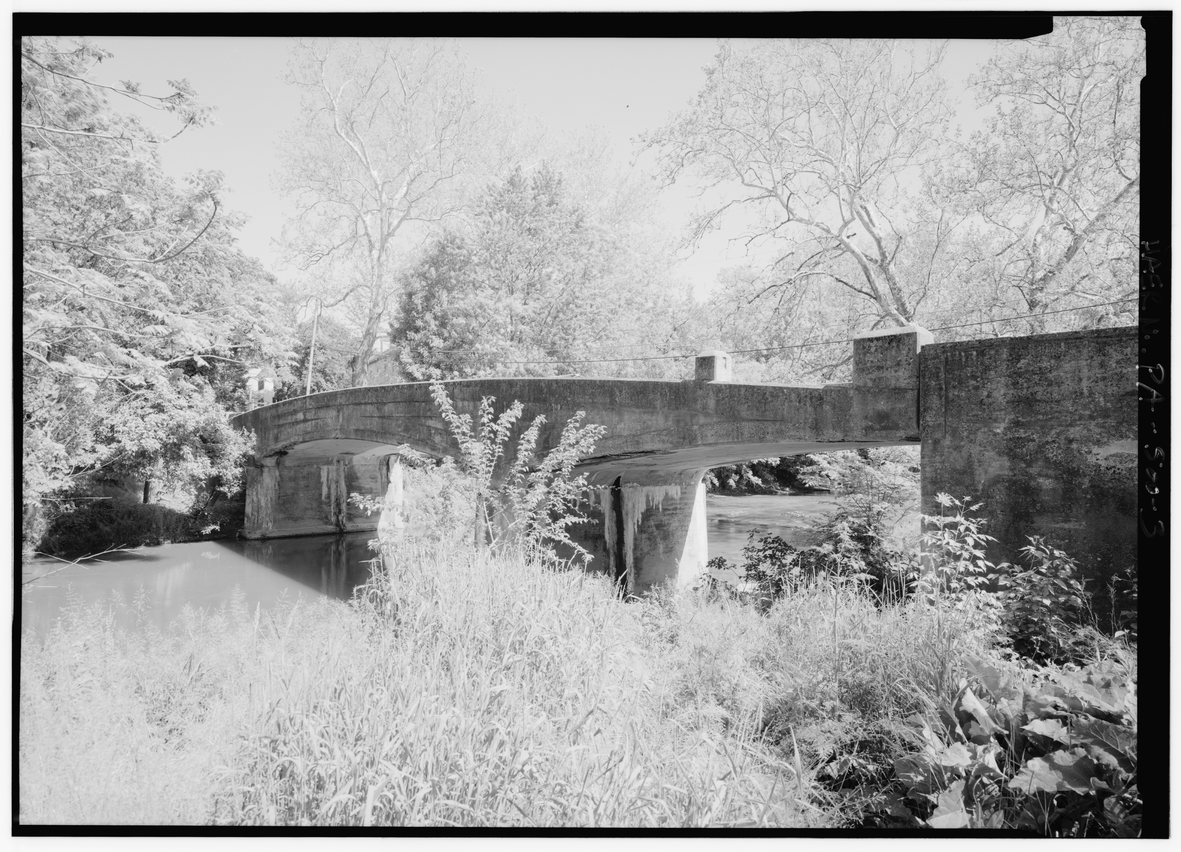
NORTH SIDE OF BRIDGE, PERSPECTIVE FROM WESTERN BANK OF RIVER. - Big Conestoga Creek Bridge No. 12, Spanning Conestoga River at Farmersville Road (State Route 1010), Brownstown, HAER PA,36-BROTO.V,1-3.tif - Fæ

SOUTH ELEVATION OF BRIDGE, LOOKING NORTH. - Big Conestoga Creek Bridge No. 12, Spanning Conestoga River at Farmersville Road (State Route 1010), Brownstown, Lancaster County, PA HAER PA,36-BROTO.V,1-4.tif - Fæ

PERSPECTIVE VIEWS OF SOUTH ELEVATION, LOOKING NORTH FROM WESTERN BANK OF RIVER. - Big Conestoga Creek Bridge No. 12, Spanning Conestoga River at Farmersville Road (State Route HAER PA,36-BROTO.V,1-5.tif - Fæ

OBLIQUE PERSPECTIVE, FROM EASTERN BANK OF RIVER. - Big Conestoga Creek Bridge No. 12, Spanning Conestoga River at Farmersville Road (State Route 1010), Brownstown, Lancaster HAER PA,36-BROTO.V,1-6.tif - Fæ

PERSPECTIVE VIEW OF WESTERN PORTAL, LOOKING EAST. - Big Conestoga Creek Bridge No. 12, Spanning Conestoga River at Farmersville Road (State Route 1010), Brownstown, Lancaster HAER PA,36-BROTO.V,1-7.tif - Fæ

DETAIL OF EASTERN ABUTMENT, SHOWING SPALLING AND EXPOSED REINFORCING BAR. - Big Conestoga Creek Bridge No. 12, Spanning Conestoga River at Farmersville Road (State Route 1010), HAER PA,36-BROTO.V,1-8.tif - Fæ

DETAIL, BUILDER'S PLATE. - Big Conestoga Creek Bridge No. 12, Spanning Conestoga River at Farmersville Road (State Route 1010), Brownstown, Lancaster County, PA HAER PA,36-BROTO.V,1-11.tif - Fæ

GENERAL VIEW, LOOKING EAST. - Big Conestoga Creek Bridge No. 12, Spanning Conestoga River at Farmersville Road (State Route 1010), Brownstown, Lancaster County, PA HAER PA,36-BROTO.V,1-1.tif - Fæ

DETAIL OF PA-500-9, SHOWING THAT ABUTMENT DOES NOT SUPPORT CANTILEVER TIP AT END OF BRIDGE. - Big Conestoga Creek Bridge No. 12, Spanning Conestoga River at Farmersville Road HAER PA,36-BROTO.V,1-10.tif - Fæ

WESTERN ABUTMENT, SHOWING THAT ABUTMENT DOES NOT SUPPORT CANTILEVER TIP AT END OF BRIDGE. - Big Conestoga Creek Bridge No. 12, Spanning Conestoga River at Farmersville Road HAER PA,36-BROTO.V,1-9.tif - Fæ

North approach to bridge, looking south across road deck. - Weaverland Bridge, Quarry Road spanning Conestoga Creek, Terre Hill, Lancaster County, PA HAER PA-589-1.tif - Fæ

Perspective of east arch section, showing five panels made up of diagonal suspension ribs and vertical ribs. The abutments, piers, wing walls, coping and deck are of concrete. - HAER PA-589-2.tif - Fæ

Interior detail of east arch section. - Weaverland Bridge, Quarry Road spanning Conestoga Creek, Terre Hill, Lancaster County, PA HAER PA-589-3.tif - Fæ

Weaverland Bridge, Quarry Road spanning Conestoga Creek, Terre Hill, Lancaster County, PA HAER PA-589 (sheet 2 of 3).tif - Fæ

Weaverland Bridge, Quarry Road spanning Conestoga Creek, Terre Hill, Lancaster County, PA HAER PA-589 (sheet 3 of 3).tif - Fæ

Weaverland Bridge, Quarry Road spanning Conestoga Creek, Terre Hill, Lancaster County, PA HAER PA-589 (sheet 1 of 3).tif - Fæ

Exterior perspective of east arch by 45". - Weaverland Bridge, Quarry Road spanning Conestoga Creek, Terre Hill, Lancaster County, PA HAER PA-589-4.tif - Fæ

Below deck detail of concrete slab decking. - Weaverland Bridge, Quarry Road spanning Conestoga Creek, Terre Hill, Lancaster County, PA HAER PA-589-5.tif - Fæ

South approach, looking north. The galvanized piping extends from the abutments across the length of the arch. - Weaverland Bridge, Quarry Road spanning Conestoga Creek, Terre Hill, HAER PA-589-7.tif - Fæ

Perspective view NW by 310. Note the concrete pier extending from the bridge in the foreground. This way to allow maximum water flow during floods and rainy periods. - Weaverland Bridge, HAER PA-589-6.tif - Fæ

3-4 view of Conestoga River Bridge. Looking NW. - Lincoln Highway, Running from Philadelphia to Pittsburgh, Fallsington, Bucks County, PA HAER PA-592-39.tif - Fæ

3-4 view of Conestoga River Bridge. Looking W. - Lincoln Highway, Running from Philadelphia to Pittsburgh, Fallsington, Bucks County, PA HAER PA-592-40.tif - Fæ

Elevation of Conestoga River Bridge, Lancaster. Looking N. - Lincoln Highway, Running from Philadelphia to Pittsburgh, Fallsington, Bucks County, PA HAER PA-592-38.tif - Fæ

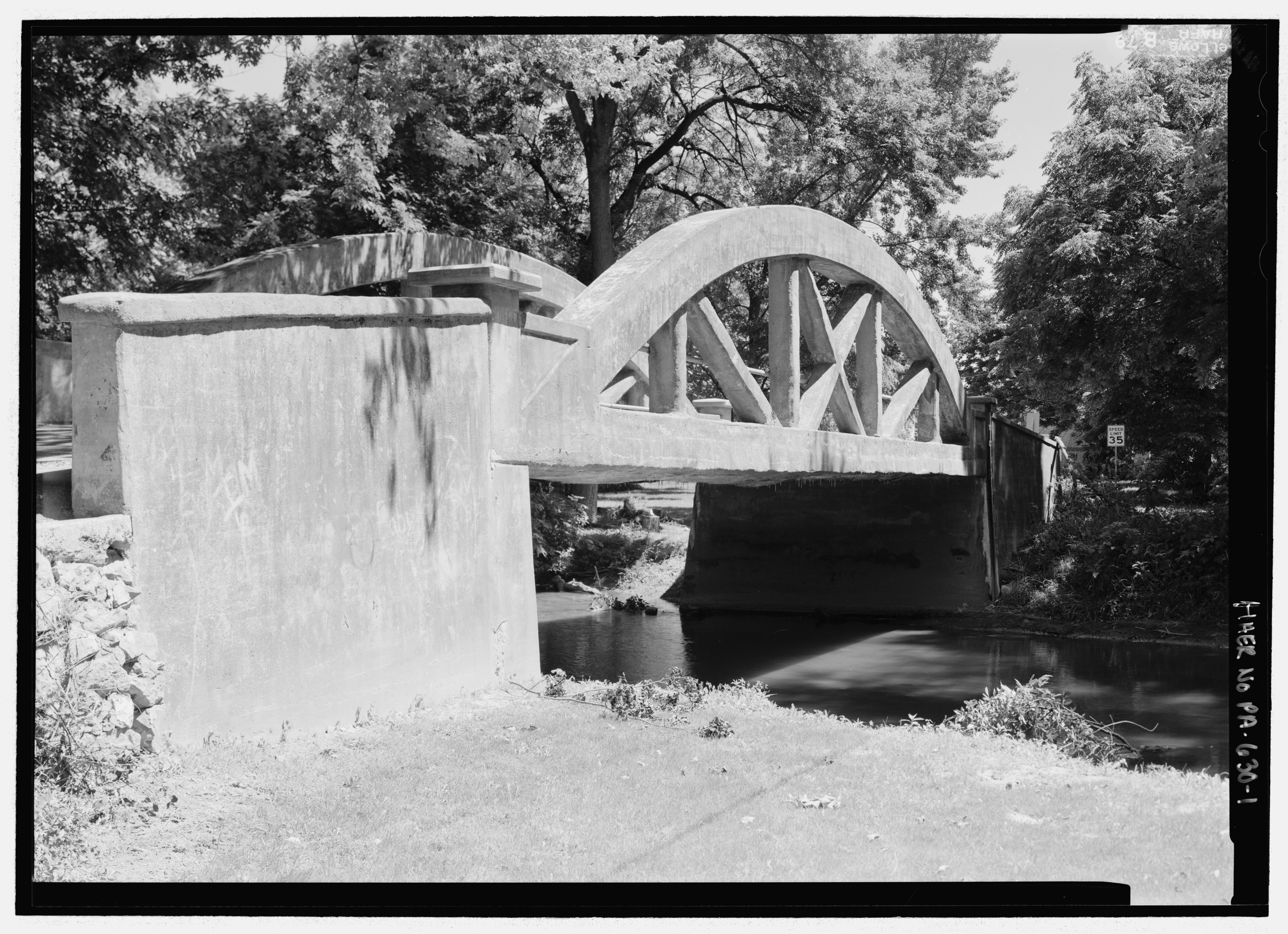
PERSPECTIVE VIEW ON SOUTH ELEVATION. - Big Chickies Bridge, Spanning Big Chickies Creek, Lancaster Junction, Lancaster County, PA HAER PA-630-1.tif - Fæ

SOUTH ELEVATION OF TIED ARCH TRUSS AND ABUTMENTS. - Big Chickies Bridge, Spanning Big Chickies Creek, Lancaster Junction, Lancaster County, PA HAER PA-630-2.tif - Fæ

PORTAL. NOTE GALVANIZED PIPE RAIL EXTENDING THE LENGTH OF THE ARCH. - Big Chickies Bridge, Spanning Big Chickies Creek, Lancaster Junction, Lancaster County, PA HAER PA-630-4.tif - Fæ

PORTAL WITH APPROACH ROAD. - Big Chickies Bridge, Spanning Big Chickies Creek, Lancaster Junction, Lancaster County, PA HAER PA-630-3.tif - Fæ

VIEW OF UNDERSIDE AND CONCRETE ABUTMENT. - Big Chickies Bridge, Spanning Big Chickies Creek, Lancaster Junction, Lancaster County, PA HAER PA-630-5.tif - Fæ

Johnson's Mill Bridge, Chickie's Creek (East Donegal-Rapho Township), Chickies, Lancaster County, PA HABS PA,36-CHICK,1- (sheet 3 of 7).tif - Fæ

Johnson's Mill Bridge, Chickie's Creek (East Donegal-Rapho Township), Chickies, Lancaster County, PA HABS PA,36-CHICK,1- (sheet 4 of 7).tif - Fæ

Johnson's Mill Bridge, Chickie's Creek (East Donegal-Rapho Township), Chickies, Lancaster County, PA HABS PA,36-CHICK,1- (sheet 5 of 7).tif - Fæ

Johnson's Mill Bridge, Chickie's Creek (East Donegal-Rapho Township), Chickies, Lancaster County, PA HABS PA,36-CHICK,1- (sheet 2 of 7).tif - Fæ

Johnson's Mill Bridge, Chickie's Creek (East Donegal-Rapho Township), Chickies, Lancaster County, PA HABS PA,36-CHICK,1- (sheet 1 of 7).tif - Fæ

Johnson's Mill Bridge, Chickie's Creek (East Donegal-Rapho Township), Chickies, Lancaster County, PA HABS PA,36-CHICK,1- (sheet 7 of 7).tif - Fæ

Johnson's Mill Bridge, Chickie's Creek (East Donegal-Rapho Township), Chickies, Lancaster County, PA HABS PA,36-CHICK,1- (sheet 6 of 7).tif - Fæ

Railroad Bridge at the Hess Homestead.jpg - Arthunter

Buildings of Ephrata Cloister.jpg - Bestbudbrian

Rock Hill Road Bridge.jpg - Nyttend

Pondtown Mill Bridge Flickr.jpg - Smallbones

HAMMER CREEK BRIDGE, LANCASTER COUNTY.jpg - KLOTZ

Susquehanna River from above the Breezyview Gazebo in Chickies Rock County Park.jpg - Kesticc

Shocks Mills Bridge.jpg - Krib

Wright's Ferry Bridge.jpg - Sarregouset

PA Turnpike Reading Interchange inbound (1), Aug. 2006.jpg - Ser Amantio di Nicolao

PA Turnpike Reading Interchange inbound (2), Aug. 2006.jpg - Ser Amantio di Nicolao

Shocks Mills Bridge Agnes Damage.png - Gamingcanary

US 222 nb at Enola Low Grade Trail bridge, Jan. 2025.jpg - Mr. Matté
❮
❯


