Wikimedi'Òc
Modes d'emploi

Cet album fait partie des albums
Cet album photos contient les sous-albums suivants :


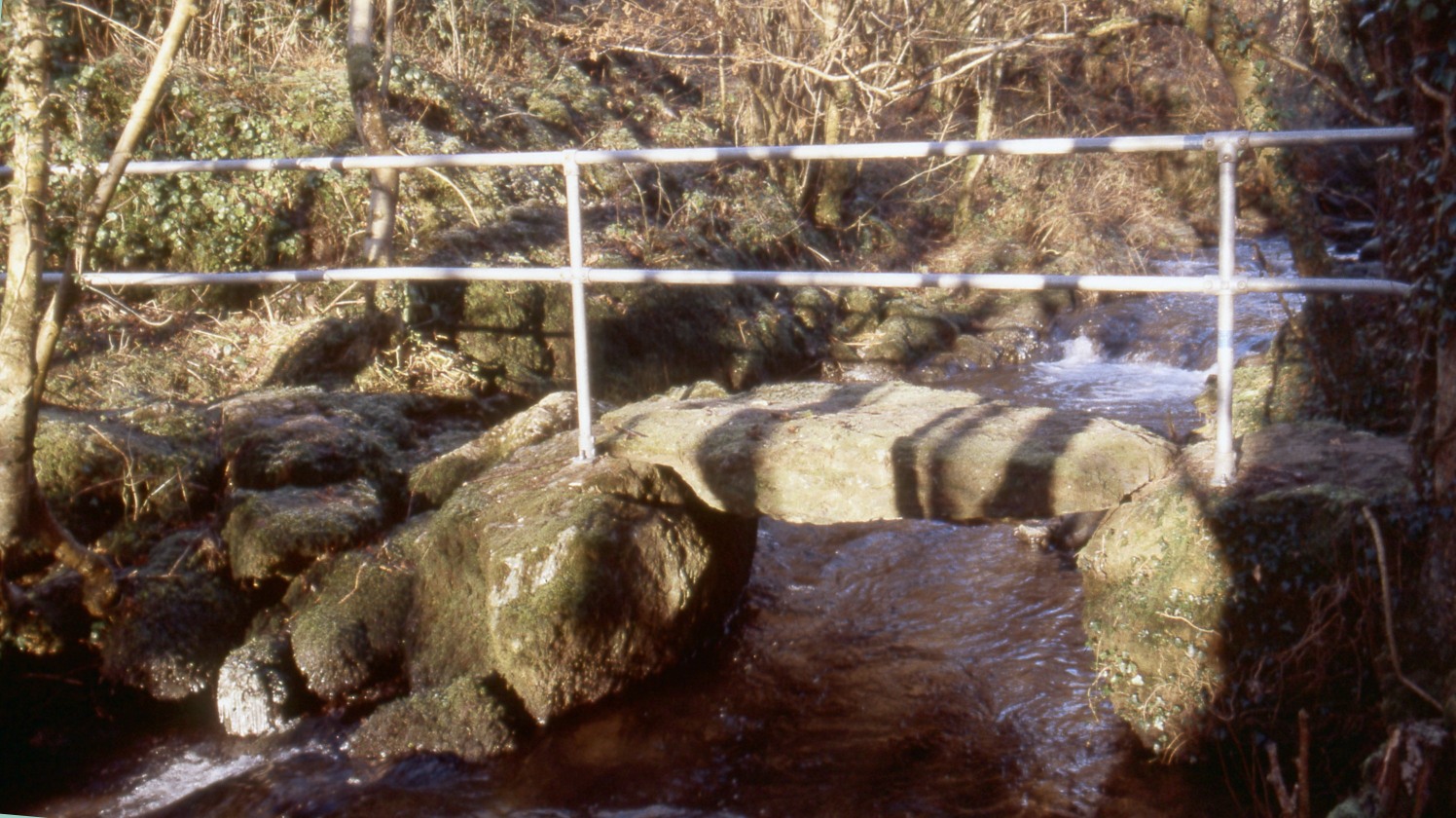
Cadnant Clapper Bridge.jpg - Velela

Four Mile Bridge - geograph.org.uk - 27835.jpg - GeographBot

Pont y Deri - geograph.org.uk - 38795.jpg - GeographBot

Pont Marquis. - geograph.org.uk - 102966.jpg - GeographBot

Bridge over railway - geograph.org.uk - 120663.jpg - GeographBot

Bridge over the river Braint, at Pont Dic - geograph.org.uk - 149432.jpg - GeographBot

Pont Glan-felin - geograph.org.uk - 156956.jpg - GeographBot

Pont Tai Hen - geograph.org.uk - 157584.jpg - GeographBot

Rail bridge - geograph.org.uk - 158252.jpg - GeographBot

Rail overbridge - geograph.org.uk - 156947.jpg - GeographBot

Old bridge over Cefni River - geograph.org.uk - 113505.jpg - GeographBot

Road Bridge Outside Beaumaris - geograph.org.uk - 161460.jpg - GeographBot

Bridge and lodge near Llynon Hall - geograph.org.uk - 171265.jpg - GeographBot

Footbridge and weir near Llynon Hall - geograph.org.uk - 171262.jpg - GeographBot

Bridge near Llangaffo - geograph.org.uk - 222643.jpg - GeographBot

South Stack Bridge - geograph.org.uk - 240399.jpg - GeographBot

Pont Malltraeth - geograph.org.uk - 255224.jpg - GeographBot

Ynys Lawd-South Stack Lighthouse from The Range - geograph.org.uk - 283654.jpg - GeographBot

Carreg yr Halen and Pont y Borth - geograph.org.uk - 381435.jpg - GeographBot

The western end of the Celtic Gateway - geograph.org.uk - 404569.jpg - Rotatebot

The estuary of Afon Cadnant and the new Cadnant bridge - geograph.org.uk - 441307.jpg - GeographBot

The new Cadnant Bridge - geograph.org.uk - 441300.jpg - GeographBot

The new Cadnant Bridge and the turning to the old bridge - geograph.org.uk - 441321.jpg - GeographBot

Bridge near Llanfachraeth - geograph.org.uk - 469578.jpg - GeographBot

Pont Britannia from Plas Newydd - geograph.org.uk - 518986.jpg - GeographBot

Pont Britannia from Plas Newydd waterfront - geograph.org.uk - 518991.jpg - GeographBot

Pont Bwcle - Bulkeley Bridge over Afon Cefni - geograph.org.uk - 515152.jpg - GeographBot

Pont Rhyd y Saint railway bridge - geograph.org.uk - 521262.jpg - GeographBot

Cafnan Bridge - geograph.org.uk - 550005.jpg - GeographBot

Elim Bridge - geograph.org.uk - 550007.jpg - GeographBot

The bridge carrying the Penrhos Road over the A55 - geograph.org.uk - 550971.jpg - GeographBot

Bridge carrying the A55 over a lane to Caergeiliog from Ysbylldir - geograph.org.uk - 579779.jpg - GeographBot

Bridge into Salt Island Holyhead (Caergybi)port. - geograph.org.uk - 579775.jpg - GeographBot

Road bridge over deeply incised valley - geograph.org.uk - 734998.jpg - GeographBot

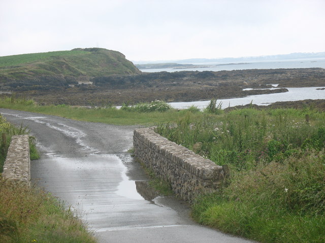
Four Mile Bridge - Pont Rhydbont - geograph.org.uk - 761130.jpg - GeographBot

Bridge over the river Braint at Pwll Fanogl - geograph.org.uk - 786181.jpg - GeographBot

The A55 north of Gaerwen - geograph.org.uk - 808017.jpg - GeographBot

The A55 from the B4545 overbridge - geograph.org.uk - 817677.jpg - GeographBot

Crossing the hump-backed Pont Marquis - geograph.org.uk - 845253.jpg - GeographBot

The Holyhead-London line passing beneath the A55 - geograph.org.uk - 870180.jpg - GeographBot

Road bridge over the A 55 on the north-western outskirts of Llanfairpwll - geograph.org.uk - 943162.jpg - GeographBot

Bridge carrying the A 55 over a minor road which links with the A 5 - geograph.org.uk - 977137.jpg - GeographBot

Pont Hafren bridge over Afon Alaw at Llanddeusant - geograph.org.uk - 983655.jpg - GeographBot

Approaching Pont Hafren bridge over Afon Alaw - geograph.org.uk - 991892.jpg - GeographBot

Afon Cefni beneath the Cefni road bridge - geograph.org.uk - 1084451.jpg - GeographBot

Pedestrian walkway on the bridge spanning Afon Wygyr - geograph.org.uk - 1110356.jpg - GeographBot

Afon Wygyr passing through the Bridge Street arch - geograph.org.uk - 1183025.jpg - GeographBot

Approaching Pont Pensarn - geograph.org.uk - 1180726.jpg - GeographBot

Approaching Pont Pensarn from the south - geograph.org.uk - 1180729.jpg - GeographBot

Approaching Pont y Deri from the west - geograph.org.uk - 1184219.jpg - GeographBot

Pont Tai Hen spanning Afon Wygyr - geograph.org.uk - 1248506.jpg - GeographBot

Bridge over the headwaters of Afon Alaw at Llanbabo - geograph.org.uk - 1319659.jpg - GeographBot

Afon Marchogion emerging from under the Beach Road bridge - geograph.org.uk - 1341378.jpg - GeographBot

Pont y Felin over Afon Alaw - geograph.org.uk - 1357619.jpg - GeographBot
Pont Porth yr Afon bridge - geograph.org.uk - 1401009.jpg - GeographBot

Cattle grid and over bridge on the new road from the Holyhead Breakwater Country Park - geograph.org.uk - 1415820.jpg - GeographBot

The London Road Bridge, Holyhead - geograph.org.uk - 1442060.jpg - GeographBot
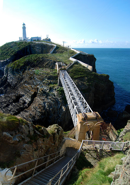
Bridge to the lighthouse - geograph.org.uk - 1497793.jpg - GeographBot

Pont Aberlleiniog - geograph.org.uk - 1540411.jpg - GeographBot

View south across Pont y Rhyd - geograph.org.uk - 1544309.jpg - GeographBot

Pont-y-Rhyd, Llangoed - geograph.org.uk - 1553004.jpg - GeographBot

Disused railway bridge in The Dingle - geograph.org.uk - 1738462.jpg - GeographBot

Bridge on Anglesey Coastal Path DSC 8326 -1.jpg - Talsarnau Times

Metalwork on Bridge on Anglesey Coastal Path DSC 8322 -1.jpg - Talsarnau Times

Metalwork on Bridge on Anglesey Coastal Path DSC 8307 -1.jpg - Talsarnau Times

Metalwork on Bridge on Anglesey Coastal Path DSC 8315 -1.jpg - Talsarnau Times

The bridge and village, Aberffro NLW3363766.jpg - Fæ

Pont Aber Alaw IMG 0647 -1.jpg - Talsarnau Times

Pont Aber Alaw IMG 1030 -1.jpg - Talsarnau Times