Wikimedi'Òc
Modes d'emploi

Cet album fait partie des albums
Cet album photos contient les sous-albums suivants :


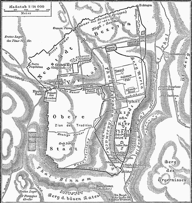
Historische Karte von Jerusalem MK1888.png - ¡0-8-15!

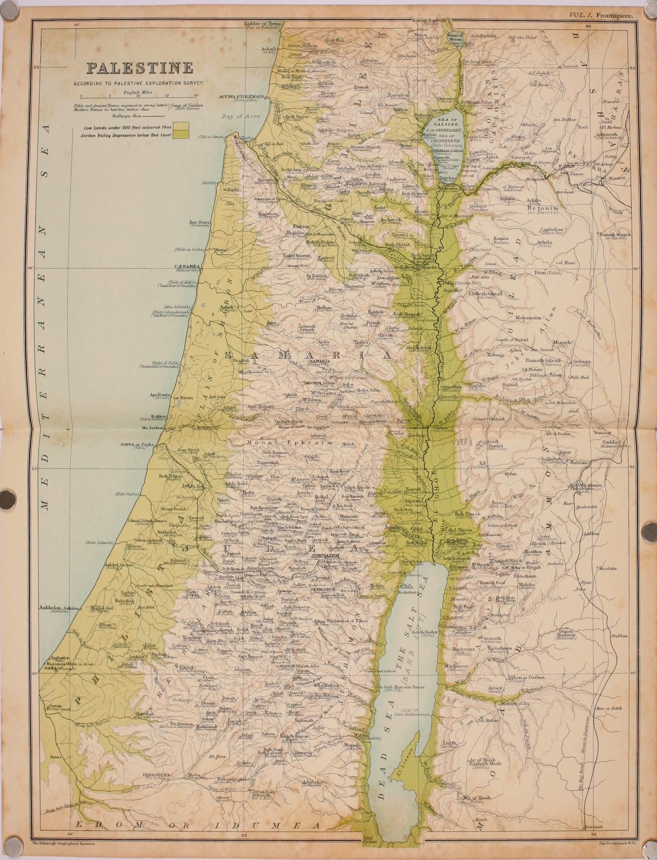
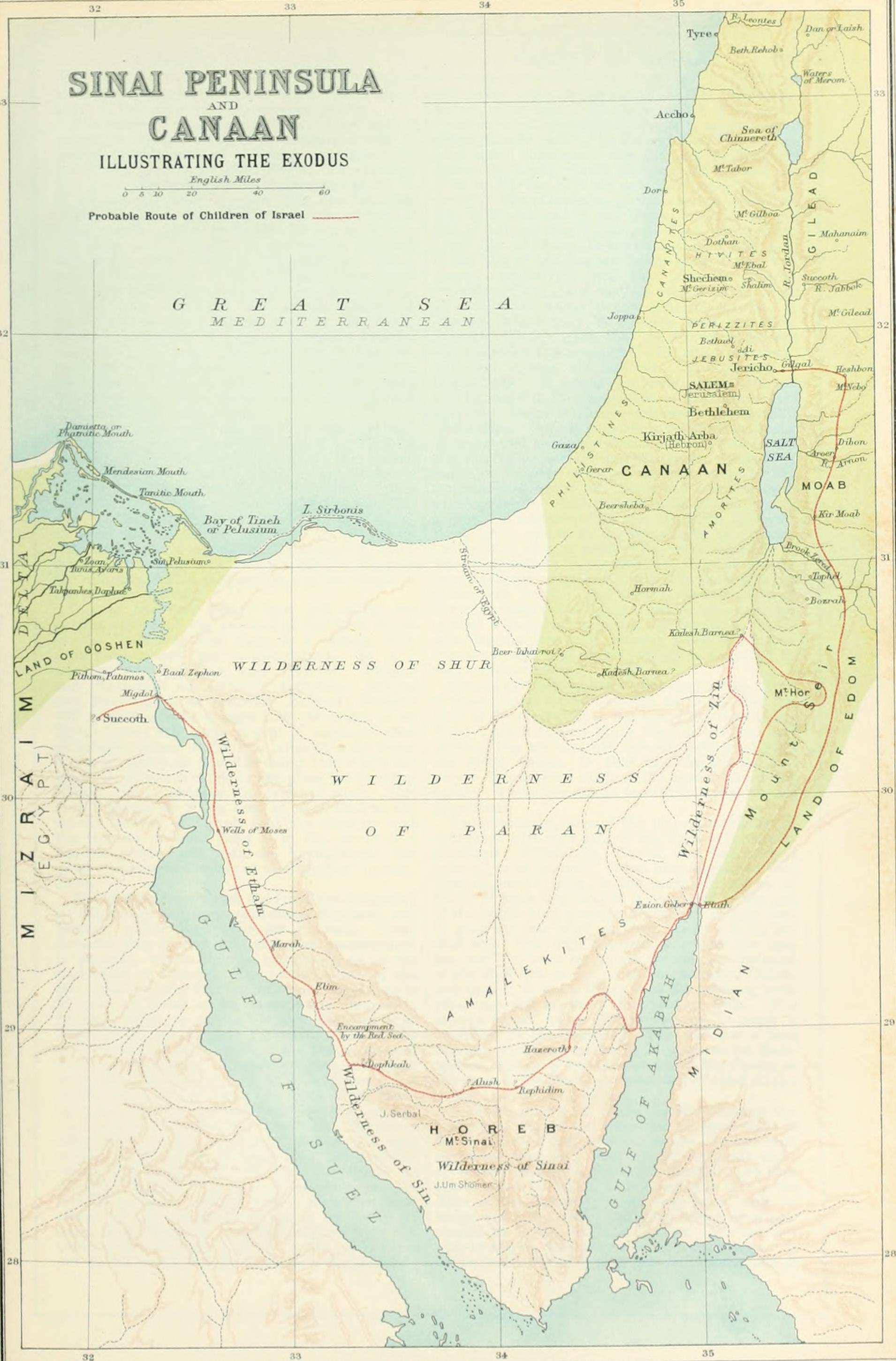
Exodus Map.jpg - GeeAlice

Levant 830 nl 3.PNG - Ben Pirard

Mapa Asyrii.png - Żbiczek

Exodus map Hebrew.jpg - Ori229

The Dead Sea and Surroundings EL.png - Pvasiliadis

Davids-kingdom with captions specifiying vassal kingdoms-derivative-work.jpg - Amoruso~commonswiki

Greater Israel map.jpg - Cansado

Ajrud.jpg - Amplifysound

C+B-Palace-Fig1-PlanOfSolomonsPalace.PNG - Newman Luke

C+B-Palace-Fig2-HouseOfForestOfLebanonPlan.PNG - Newman Luke

C+B-Geography-Map2-IsraeliteWorldviewDuringJudges.PNG - Newman Luke

C+B-Geography-Map3-IsraeliteWorldviewIn10thCentury.PNG - Newman Luke

C+B-Geography-Map4-IsraeliteWorldviewIn8thCentury.PNG - Newman Luke

C+B-Geography-Map5-IsraeliteWorldviewIn5thCentury.PNG - Newman Luke

C+B-Galatia-Map.JPG - Newman Luke

C+B-Goshen-MapOfVicinity.PNG - Newman Luke

C+B-Exodus-Map.PNG - Newman Luke
Matthew Jesus Resurrection Map.jpg - Joehrlin

Kingdoms around Israel 830 map.svg - Muchado

Siloam map.jpg - Tamarah

JBS1956-A 1cover.png - Bethlehem4

JBS1956-A 2index.png - Bethlehem4
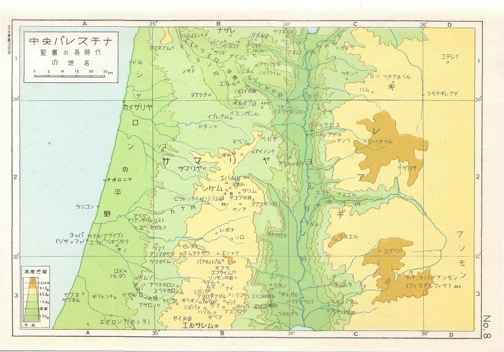
JBS1956-B map01.png - Bethlehem4

JBS1956-B map02.png - Bethlehem4
JBS1956-B map03.png - Bethlehem4

JBS1956-B map04 4a.png - Bethlehem4

JBS1956-B map05 6.png - Bethlehem4

JBS1956-B map07.png - Bethlehem4
JBS1956-B map08.png - Bethlehem4

JBS1956-B map09.png - Bethlehem4
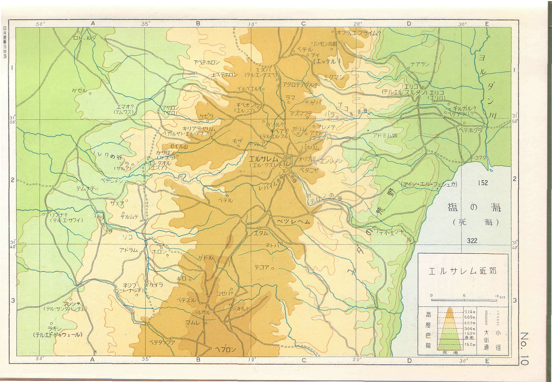
JBS1956-B map10.png - Bethlehem4

JBS1956-B map11.png - Bethlehem4

JBS1956-B map13 14.png - Bethlehem4

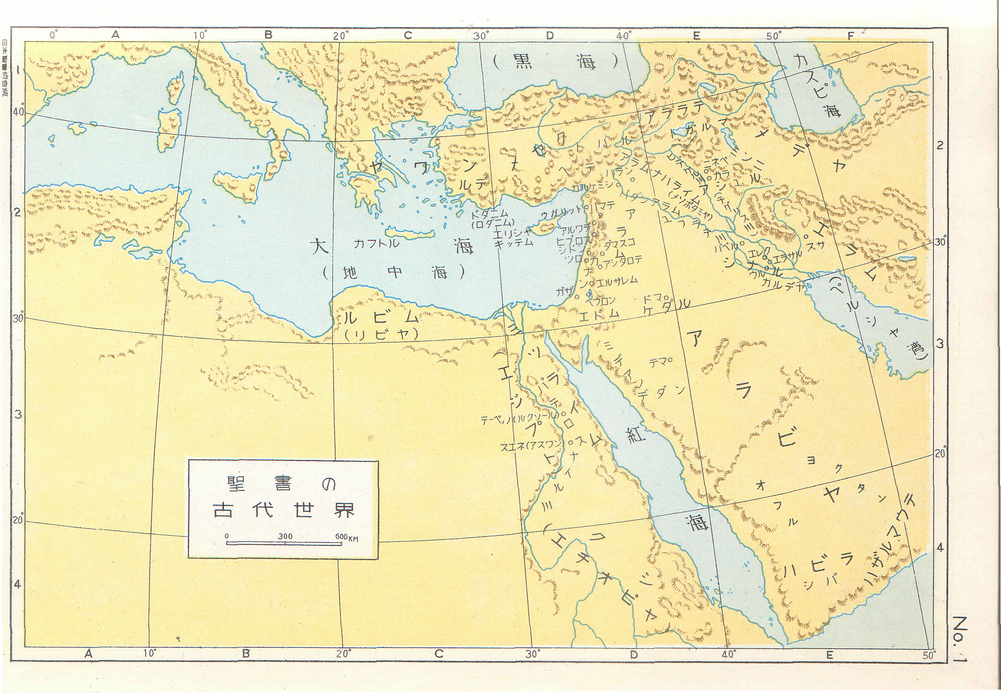
1843 Malte Brun Map of the Biblical Lands of the Hebrews (Egypt, Arabia, Israel, Turkey) - Geographicus - Hebreux-maltebrun-1837.jpg - BotMultichill
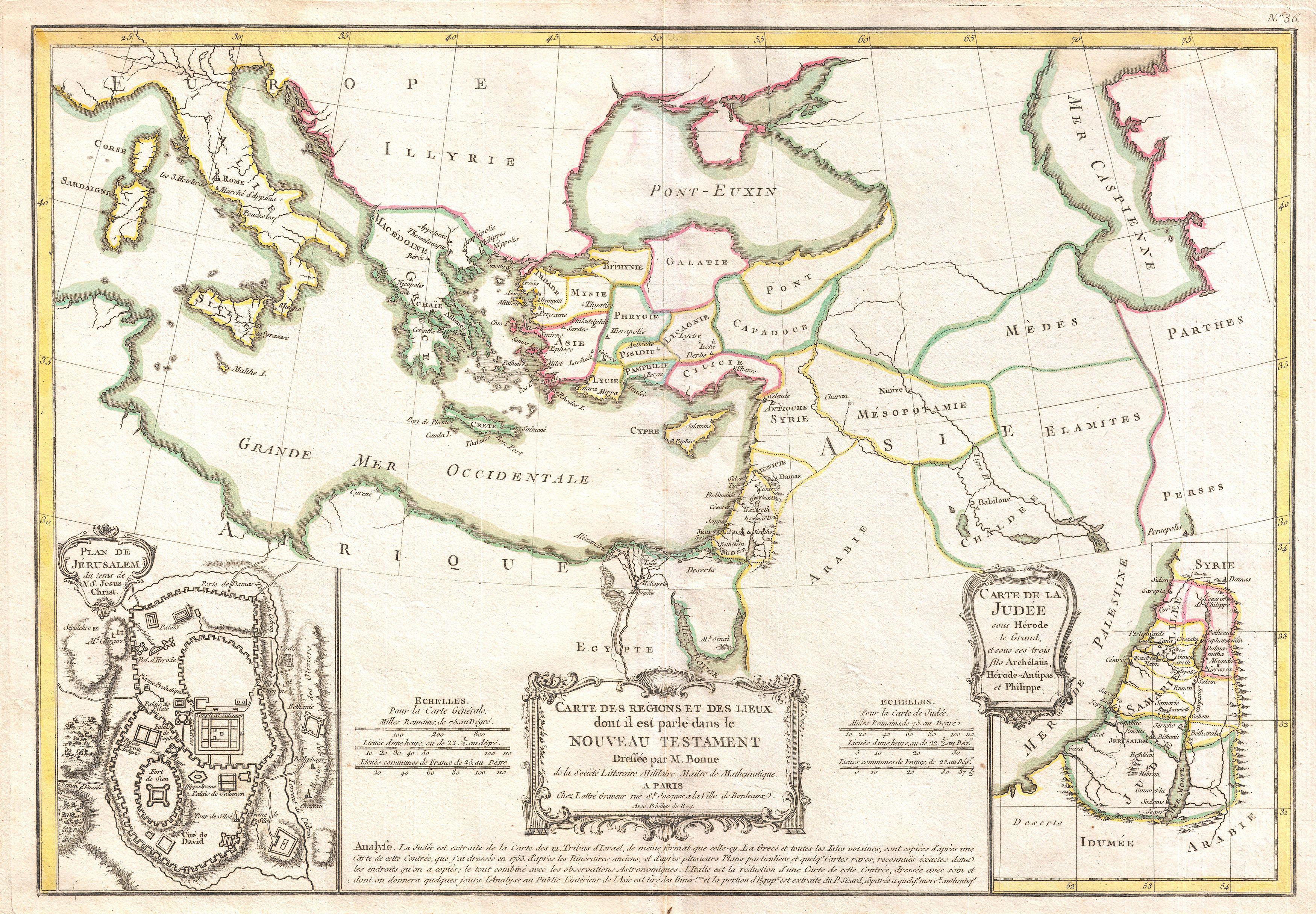
1771 Bonne Map of the New Testament Lands, w- Holy Land and Jerusalem - Geographicus - NewTestament-bonne-1771.jpg - BotMultichillT

1728 Calmet Map of the Ancient World Showing the Creation of the Universe - Geographicus - AncientWorld-calmet-1728.jpg - BotMultichillT

1662 Jansson and Hornius Map of the Holy Land, Israel, and Palestine - Geographicus - HolyLand-jansson-1662.jpg - BotMultichillT

1702 Visscher Stoopendaal Map of Israel, Palestine or the Holy Land - Geographicus - PerigrinatiaeVeertich-stoopendaal-1702.jpg - BotMultichillT

1720 Funck Map of Israel - Palestine - Holy Land - Geographicus - TerraeSanctae-funck-1720.jpg - BotMultichillT

אהרן בן חיים. 1836. מפת גבולי ארץ הצבי. ורשה 1883.jpg - Geagea

אהרן בן חיים. 1836. מפת גבולי ארץ הצבי. התרס.jpg - Geagea

MapCitiesOfRefuge.svg - Oriaaaass~commonswiki

Kingdoms around Israel 830 map sr.svg - BokicaK

Kingdoms around Israel 830 map sh.svg - BokicaK

Levant 830-HE.svg - Ori~
Kingdoms of the Levant Map 830.xcf - Dlv999

Herods Promontory Palace Map P1100187.JPG - Deror avi

Aramaic kingdoms and chiefdoms around 10-9th century BC.svg - Kmhkmh

Levant 830 map-pt.svg - Renato de Carvalho Ferreira

Kingdoms of Israel and Judah map 830-pt.svg - Renato de Carvalho Ferreira

Kingdoms around Israel 830 map-pt.svg - Xsqwiypb

Kingdom of Moab 830 map-pt.svg - Renato de Carvalho Ferreira

Kingdom of Ammon 830 map-pt.svg - Renato de Carvalho Ferreira

Kingdom of Edom 830 map-pt.svg - Renato de Carvalho Ferreira

Kingdom of Damascus 830 map-pt.svg - Renato de Carvalho Ferreira

Kingdom of Philistines 830 map-pt.svg - Renato de Carvalho Ferreira

Second Map of Sacred Geography Gathered from the Old and New Testaments- This Map Shows the Promised Land Divided into Its Tribes and Regions WDL2885.png - Fæ

This (is being produced) so that all can know the route of the travels (of the Israelites) 40 years in the desert (through) the width and length of the Holy Land from the Nile to the city of Damascus, WDL2887.png - Fæ

A Geographical Rendering of Judaea, or the Land of Israel, in Which the Positions of the Most Famous Places in the Old and New Testament are Precisely Depicted WDL2888.png - Fæ

The Situation of the Promised Land Accurately Reveals a Knowledge of the Holy Bible WDL2889.png - Fæ

Judaea or the Holy Land, Here Divided into the Twelve Tribes of the Hebrews or Israelites WDL409.png - Fæ

Schedelsche Weltchronik — Secunda etas mundi — Folio 12v 13r.jpg - Mattes

Schedelsche Weltchronik — Secunda etas mundi — Folio 12v.jpg - Mattes

Cana Where.png - Danny lost
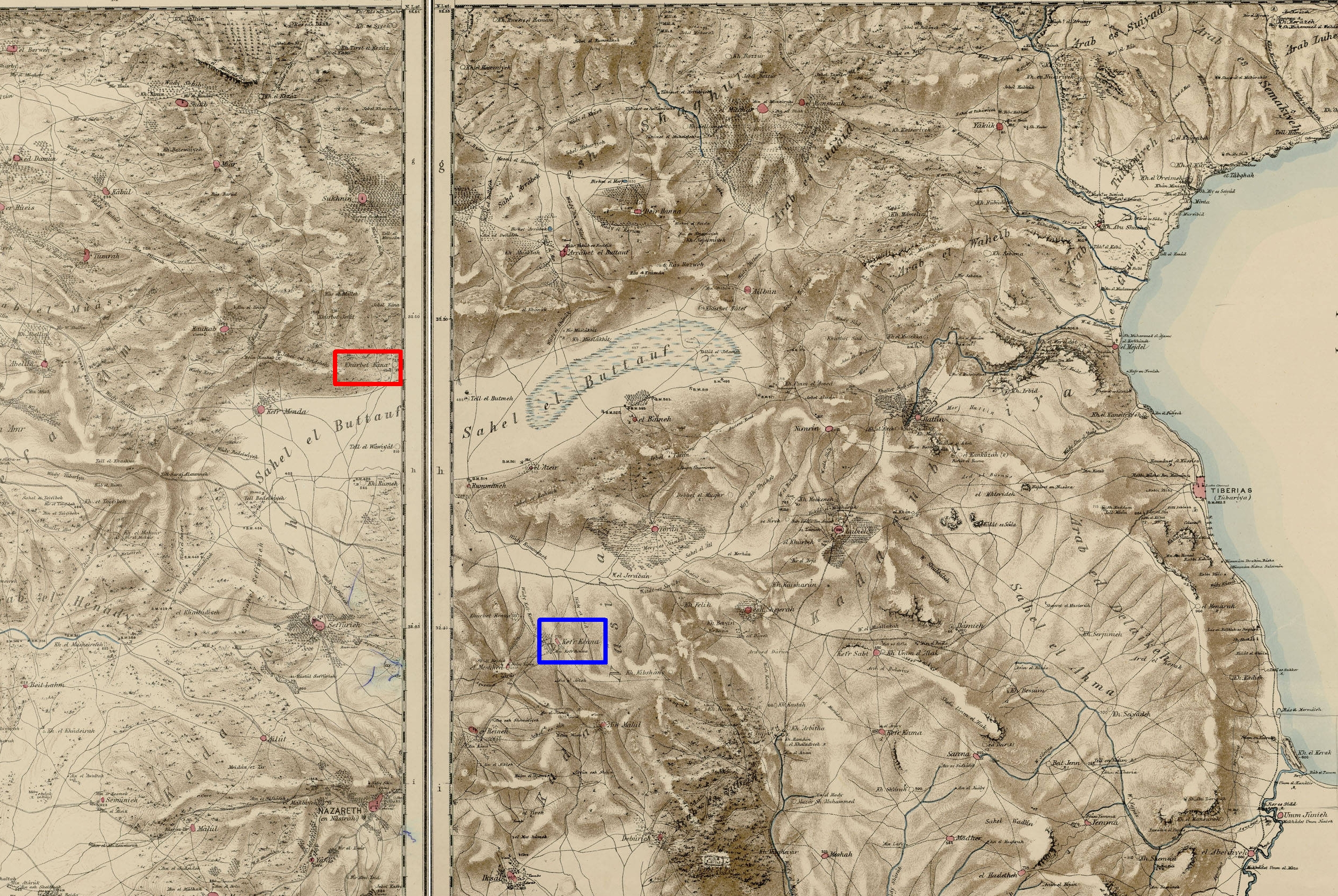
Lower Galilee Cana marks.jpg - Danny lost

Kingdoms around Israel 830 map-es.svg - Rowanwindwhistler

Bowyer Bible Volume 2 Print 340. Map of the Bible Lands. Genesis. Anonymous.png - GifTagger

Kingdom of Ammon 830 map-ar.png - Freedom's Falcon

Levant 830 nl 3-ar.png - Freedom's Falcon

Kingdoms around Israel 830 map-el.svg - Wikibelgiaan

Kingdoms around Israel 830 map-nl.svg - Wikibelgiaan

Royaumes autour d'Israel en 830.svg - Manlleus

The art Bible, comprising the Old and new Testaments - with numerous illustrations (1896) (14596405910).jpg - Fæ

The art Bible, comprising the Old and new Testaments - with numerous illustrations (1896) (14596271007).jpg - SteinsplitterBot

The art Bible, comprising the Old and new Testaments - with numerous illustrations (1896) (14595936850).jpg - Fæ

A dictionary of the Bible.. (1887) (14595257738).jpg - SteinsplitterBot

Kingdom of Philistines 830 map-es.svg - Rowanwindwhistler

Levante 830-es.svg - Rowanwindwhistler

Philistine language.svg - Qoan
The Book of Job - translated from the Hebrew on the basis of the authorized version - explained in a large body of notes, critical and exegetical, and illustrated by extracts from various works on (14778138564).jpg - Fæ

Moab 830-es.svg - Qoan

Edom 830-es.svg - Qoan

Amón 830-es.svg - Qoan

Bible manual. Introductory course on the Bible, for teachers training classes and Bible classes (1922) (14749893286).jpg - SteinsplitterBot

The Holy Bible according to the Authorized version - with notes, explanatory and practical; taken principally from the most eminent writers of the United Church of England and Ireland, together with (14769832481).jpg - SteinsplitterBot

The art Bible, comprising the Old and new Testaments - with numerous illustrations (1896) (14595995527).jpg - Fæ

The Holy Bible according to the Authorized version - with notes, explanatory and practical; taken principally from the most eminent writers of the United Church of England and Ireland, together with (14586308790).jpg - Fæ

The Holy Bible according to the Authorized version - with notes, explanatory and practical; taken principally from the most eminent writers of the United Church of England and Ireland, together with (14792881883).jpg - SteinsplitterBot

The Holy Bible according to the Authorized version - with notes, explanatory and practical; taken principally from the most eminent writers of the United Church of England and Ireland, together with (14749995896).jpg - SteinsplitterBot

A history of all nations from the earliest times; being a universal historical library (1905) (14595665257).jpg - Fæ
The Holy Bible containing the Old and New Testaments - translated out of the original tongues, being the version set forth A.D. 1611. Compared with the most ancient authorities and revised A.D. (14771722335).jpg - Fæ

The Holy Bible - a facsimile in a reduced size of the Authorized version published in the year 1611 (1911) (14766057595).jpg - Fæ

The Bible and its story.. (1908) (14740255176).jpg - SteinsplitterBot
Georgin François, The 3 Roads to Eternity, 1825 Cornell CUL PJM 1040 01.jpg - EVDiam
Jacob Skeen Genealogical Chronological and Geographical Chart 1887 Cornell CUL PJM 2085 03.jpg - Jklamo
A Geographical Rendering of Judaea, or the Land of Israel, in Which the Positions of the Most Famous Places in the Old and New Testament are Precisely Depicted WDL2888 (cropped).png - Geagea

Den Bergh van olniolen - Peeters Jacob - 1686.jpg - Gts-tg

Map of sacred geography by Abraham Ortelius.jpeg - File Upload Bot (Kaldari)

Antique jew diaspora map fr.svg - Pethrus

Antique jew diaspora map with Acts of the Apostles mention highlight.svg - Pethrus

Aegyptus Antiqua.jpg - Filbluz

Chaim Solomon Pinia. Panorama des heiligen Landes. 1875.jpg - Geagea

Tierra Santa.png - Fernando de Gorocica

Kingdoms around Israel 830 map-de.png - Partynia

Map of Palestine and all Bible lands, containing the ancient and modern names of all known places, a table of seasons, weather, productions, etc., the journeys of the Israelites from Egypt, the world (10139457793).jpg - Ww2censor

395 of 'Jacob's Flight; or a Pilgrimage to Harran and thence in the Patriarch's footsteps into the Promised Land. With illustrations ... With an introduction and a map by Dr. Beke' (11071102263).jpg - Artix Kreiger 2

312 of 'The Far East; or, Letters from Egypt, Palestine, and other lands of the Orient. Illustrated, etc' (11243856514).jpg - Artix Kreiger 2

26 of 'The Holy Sepulchre and the Temple at Jerusalem. Being the substance of two lectures delivered ... on the 21st February, 1862, and 3rd March, 1865' (11241027613).jpg - Artix Kreiger 2

19 of 'Calvary and the Tomb' (11290074214).jpg - Artix Kreiger 2

66 of 'Buried Cities and Bible Countries' (11211391176).jpg - FlickreviewR 2

Aramaic kingdoms and chiefdoms around 10-9th century BC (es).svg - Althair

Námořní cesta Jaffa - Taršíš, Tarsus.png - Xerostomus
מואב.png - Erunberri

Location of Bethsaida map.png - Jacek555

Prophecies of Jonah, Micah and Nahum.jpg - Racconish

A Szentföld Idvezítőnk korában.jpg - 12akd

Ca. 1690 biblical map of the Middle East.jpg - Balkanique

Ca. 1690 Dutch, biblical map of the Middle East.jpg - Balkanique
Geographia Sacra.jpg - Balkanique

A New Map Shewing all the several Counties, Cities, Towns, and other Places mentioned in the New Testament.jpg - Balkanique

Carte du Paradis Terrestre.jpg - Jim Into Mystery

Pavlusun vaizlik turları.jpg - Yohaim

Pavlusun onlara yazdığı cemaatler.jpg - Yohaim

Millerler Tablosu Yafet'in soyu.jpg - Yohaim
Siloam Map.pdf - FlorinCB

Millerler Tablosu- Yafet'in soyu.jpg - Yohaim

Milletler Tablosu (Genesis 10) Yafet'in soyu.jpg - Yohaim

Milletler Tablosu (Genesis 10) Ham'ın soyu.jpg - Yohaim

Milletler Tablosu (Genesis 10) Sam'ın soyu.jpg - Yohaim

İbrahim'in yolculuğu.jpg - Yohaim

Har HaBayit Map of Jerusalem 1903-Sanday-William-(d.1920)-Waterhouse-Paul-(d.1924)-Contours-Conrad Schick(d.1901cem.Mt.Zion)-CCv0-rev9.jpg - FlorinCB

Har HaBayit Map of Jerusalem 1903-Sanday-William-(d.1920)-Waterhouse-Paul-(d.1924)-Contours-Conrad Schick(d.1901cem.Mt.Zion)-CCv0-v2.9.svg - FlorinCB

Hæc chorographia præpocapiti 33. libri numer Responsibility, G. Postel, 1555.jpg - Onceinawhile

Paradisi terrestris et circumjacentium regionum situs - opus posthumum Guillelmi de l'Isle, 1719 delineatum ; Josephus Nicolaus de l'Isle... - btv1b5963575p.jpg - Gzen92Bot

Orbis antiquus quem libri sacri nec non ecclesiastici describunt - btv1b550108308.jpg - Gzen92Bot

Orbis Bibliis sacris cognitus, seu geographia sacra. Carte de la géographie sacrée pour l'Ancien Testament... - par Pierre Moullart-Sanson, 1716 - btv1b53063554v.jpg - Gzen92Bot

Paradisi terrestris et circumjacentium regionum situs - opus posthumum Guillelmi de l'Isle... anno 1719 delineatum ; Josephus Nicolaus de l'Isle - btv1b53119604z.jpg - Gzen92Bot

Paradisi terrestris et circumjacentium regionum situs - opus posthumum Guillelmi de l'Isle, 1719 delineatum ; Josephus Nicolaus de l'Isle - btv1b8495424w.jpg - Gzen92Bot

Korean Revised Edition Map 3.jpg - Aspere

Korean Revised Edition Map 2.jpg - Aspere

Korean Revised Edition Map 1.jpg - Aspere

Korean Revised Edition Map 5.jpg - Aspere

Korean Revised Edition Map 6.jpg - Aspere

Map-of-philistine-cities-battles.jpg - Josafá1

Canaan. 1662 Jansson and Hornius Map of the Holy Land, Israel, and Palestine - Geographicus - HolyLand-jansson-1662 (cropped).jpg - Geagea
Herodian Tetrarchy 2.png - Thinker78

Kingdoms around Israel 830 map mk.svg - Bjankuloski06

Havilah.png - Gurdjieff

Louis-Isaac Lemaistre de Sacy, La Terre Sainte Divisee en ses Douze Tribus (FL45611901 3950761).jpg - Geagea

Horvat Teman's couple and 'Yahweh and his Asherah' inscription.jpg - פעמי-עליון

셩경젼셔 지도 1.jpg - Aspere

셩경젼셔 지도 2.jpg - Aspere

1873 map of Sinai Peninsula during Exodus.jpg - Enyavar

1873 map of the travels of Apostle Paul.jpg - Enyavar

1873 plan of Jerusalem's holy places.jpg - Enyavar

Dictionnaire de la Bible - F. Vigouroux - Tome I - 40-Afrique des prophetes.jpg - Verbex

A general map of Bible Lands.jpg - Universalis

Biblia nchi ramani.jpg - Kipala
A dictionary of the Bible; dealing with its language, literature, and contents, including the Biblical theology; (1898) (14759548936).jpg - SteinsplitterBot

A dictionary of the Bible; dealing with its language, literature, and contents, including the Biblical theology; (1898) (14596041107).jpg - SteinsplitterBot
A dictionary of the Bible; dealing with its language, literature, and contents, including the Biblical theology; (1898) (14595847020).jpg - Fæ

Bunting clover leaf 17369 Die ganze Welt in ein Kleberblat... Altea Gallery.jpg - Lucamaphistory