Wikimedi'Òc
Modes d'emploi

Cet album fait partie des albums
Cet album photos contient les sous-albums suivants :


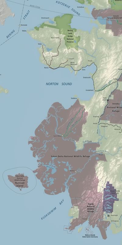
Western Alaska map 400x800.jpg - Dankarl

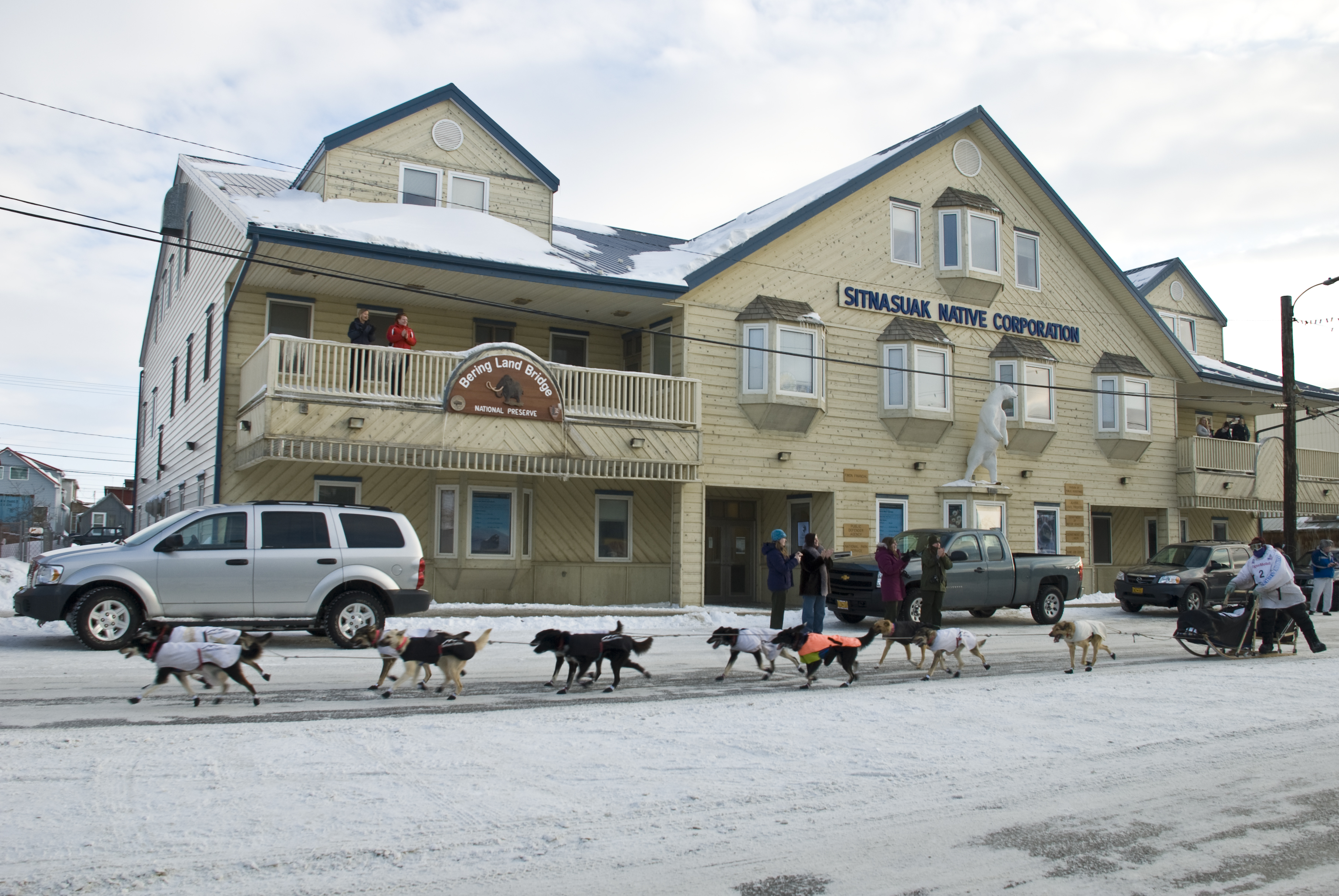
Snowmachine sign (9922717175).jpg - Ser Amantio di Nicolao

Tent Camp (9511194249).jpg - Ser Amantio di Nicolao

Aerial view of Nome (9511349455).jpg - Ser Amantio di Nicolao

Artifact at an Archaelogical Dig (9514193182).jpg - Ser Amantio di Nicolao

Schist Fragment (9514356662).jpg - Ser Amantio di Nicolao

Aurora lights up the Northern Night (9511577679).jpg - Ser Amantio di Nicolao

Sea Ice on the Nome Shorefront (9514361910).jpg - Ser Amantio di Nicolao

Solstise Sunrise at Nome (9511665933).jpg - Ser Amantio di Nicolao
Mush! (8573213368).jpg - Ser Amantio di Nicolao

Red Lantern winner Christine Roalof's dogs (8572050671).jpg - Ser Amantio di Nicolao

Winter Solstice noon sunrise on the Bering Sea (8433692952).jpg - Ser Amantio di Nicolao

Surface Hoarfrost (8289022130).jpg - Ser Amantio di Nicolao

Sea Ice Wedges (8287944603).jpg - Ser Amantio di Nicolao

Rosy morning sky (7977089246).jpg - Ser Amantio di Nicolao

Rosy sky (7977105176).jpg - Ser Amantio di Nicolao

Beaver pond (7977121519).jpg - Ser Amantio di Nicolao

Stone Structure and Caribou Antler (7853630200).jpg - Ser Amantio di Nicolao

Hiking through willows (7692330248).jpg - Ser Amantio di Nicolao

Is this a Frost Boil or Man Made? (5961256023).jpg - Ser Amantio di Nicolao

Is this a Frost Boil or a Man Made? (5961263159).jpg - Ser Amantio di Nicolao

"Caribou" Migration Parade (4778244031).jpg - Ser Amantio di Nicolao

Spring Sea Ice (4604729649).jpg - Ser Amantio di Nicolao

It's Beginning to Look A Lot like...... (4409101753).jpg - Ser Amantio di Nicolao

Cache in Bering Land Bridge (3551113632).jpg - Ser Amantio di Nicolao

Wox from Upper Darby PA (4115144931).jpg - Ser Amantio di Nicolao

Sunset (3767406512).jpg - Ser Amantio di Nicolao

Bering Land Bridge National Preserve.png - GifTagger

Arctic Hot Springs (16189187209).jpg - Holly Cheng
The Bering Land Bridge Preserve in Alaska ESA203691.tiff - Fæ

The Bering Land Bridge Preserve in Alaska ESA203691.jpg - Fæ

Bering Land Bridge Preserve 95.jpg - MarginalCost

Sullivan Bluffs - DPLA - 0042791ca693dca982ebcbd5b8baba4d.jpg - DPLA bot

Sullivan Bluffs - DPLA - e919a795e02e4557eb6143dab01255ff.jpg - DPLA bot

Rock hammer in a lava rock cavity. (64ac4b6a-b25f-4b75-9622-b4815e3a33df).jpg - BMacZeroBot

Hiking among the tors. (a4e32f1a-1250-4398-9bda-f62ab8c3a91a).JPG - BMacZeroBot
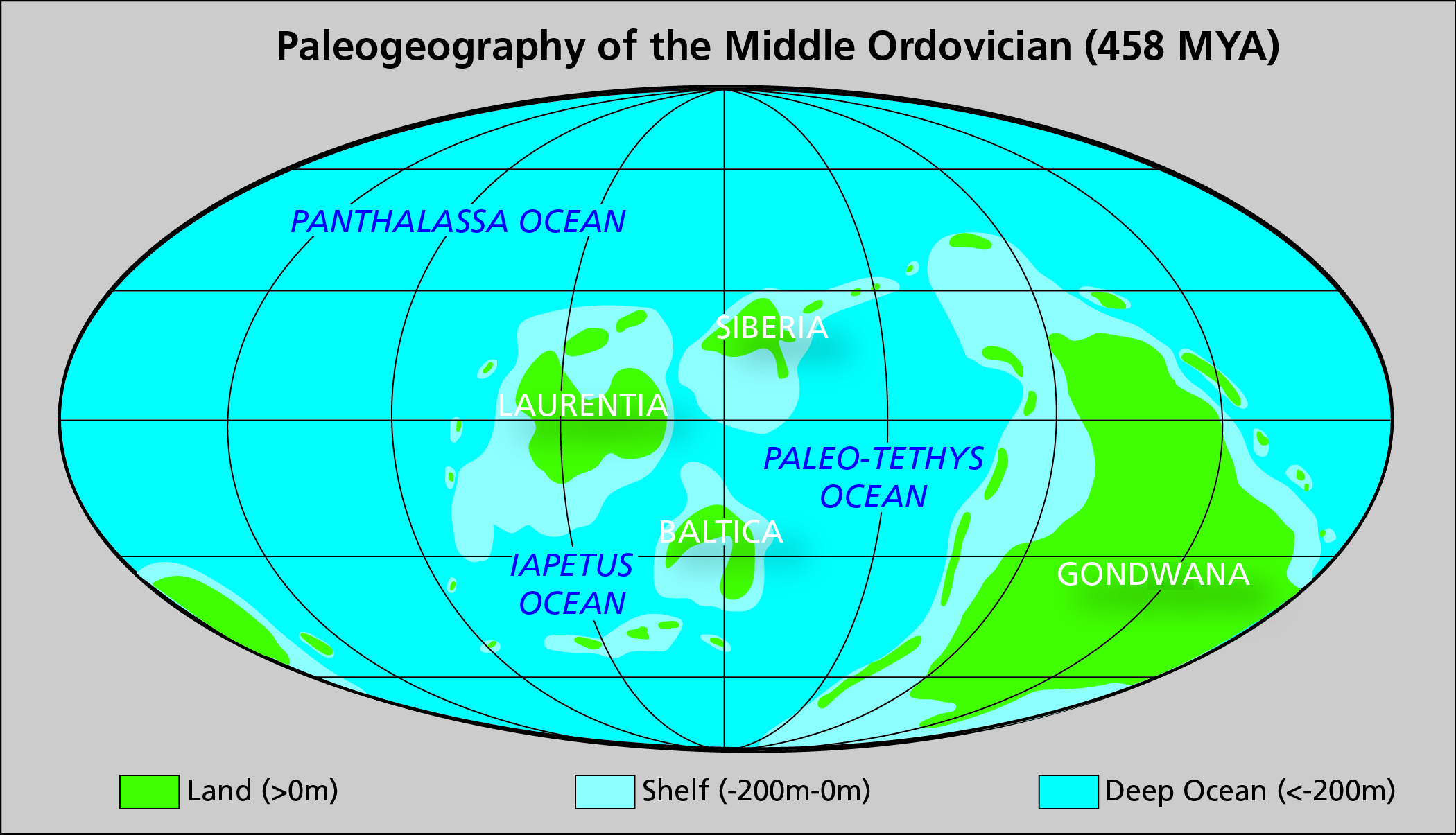
Map showing the paleogeography of the Middle Ordovician (approximately 458 million years ago). Most researchers place western (2de3cd16-15cc-4d0c-b553-71cbbeb4c7e3).jpg - BMacZeroBot

Satellite View of the Thaw-Lake Plain (3cb35dd0-5a5b-4cd1-9637-99c77958e798).jpg - BMacZeroBot

The Espenberg volcanic field (top) is in the northern part of the preserve (A). The Imuruk volcanic field (bottom) is in the (565dd972-b275-4982-9f85-735f7a75791a).jpg - BMacZeroBot

The map shows the location of Cenozoic volcanic rocks (light and dark pink), public shelter cabins (blue symbols and labels (ac9ed760-07e6-4349-8eaf-883201860057).jpg - BMacZeroBot

Bering Land Bridge National Preserve (Shishmaref barrier islands).jpg - Fumikas Sagisavas

Ken Adkisson, Subsistence Program Manager, Bering Land Bridge National Preserve. (0ccd0e13-6a24-4303-b330-155c09331248).jpg - BMacZeroBot

Jeanette Koelsch, Superintendent, Bering Land Bridge National Preserve (4dd53d96-87a4-4b11-bfba-9a97e7bbe816).jpg - BMacZeroBot

Bering Land Bridge National Preserve, Alaska (ecb9b4fc-d0d4-41d0-91ee-a5821c5bbe7e).jpg - BMacZeroBot

Marine Debris Display- Bering Land Bridge National Preserve, Full Exhibit (284c4b11-0e98-4060-8f4f-d4070bc41d68).jpg - BMacZeroBot

Marine Debris Display- Bering Land Bridge, Interactive Display (6057852f-603a-4e03-8799-5668efa83f2c).png - BMacZeroBot

Marine Debris Display- Bering Land Bridge National Preserve, Call-to-Action Panels (b547ba03-aedc-4e75-b3b9-f6e8c50f6ac5).jpg - BMacZeroBot

Marine Debris Display- Bering Land Bridge National Preserve, Map Table and Mural (da5c1578-1e97-48f6-ab3e-21410ce5eeaf).jpg - BMacZeroBot

Bering land Bridge BioBlitz postcard (43b73eab-1dd8-b71b-0b64-66ff43ecdfdf).jpg - BMacZeroBot

Bioblitzers climb the tors at Serpentine Hot Springs, Bering Land Bridge National Preserve. (5c59c933-1dd8-b71b-0b7e-e108d4d8d132).JPG - BMacZeroBot

Timary from Shishmaref holding the snow scorpionfly she found. (5d580920-1dd8-b71b-0b82-a119ffe5dacd).jpg - BMacZeroBot

Collecting insects on the tundra during the Bering Land Bridge bioblitz. (5d7b89e5-1dd8-b71b-0b06-39d853aa7be8).JPG - BMacZeroBot

Singing the bioblitz song at Serpentine Hot Springs, Bering Land Bridge. (5f8377b1-1dd8-b71b-0b86-8766b7e49b62).JPG - BMacZeroBot
Clear Skies Over Bering Land Bridge National Preserve (NESDIS 2019-06-14).jpg - OptimusPrimeBot

Youth from the Bering Land Bridge bioblitz climb on the tors at Serpentine Hot Springs (fccc68b8-1dd8-b71b-0bd3-cfffd0014d81).JPG - BMacZeroBot

Bioblitz participants pose for a group shot at the tors at Serpentine Hot Springs, Bering Land Bridge National Preserve. (fcdcf9f2-1dd8-b71b-0b5d-67297f8d4f3b).jpg - BMacZeroBot

A bioblitz participant catches insects at Serpentine Hot Springs, Bering Land Bridge National Preserve. (fce23489-1dd8-b71b-0bfa-9c2df1416e5d).JPG - BMacZeroBot

A researcher collects insects on the tundra at Serpentine Hot Springs as part of the Bering Land Bridge bioblitz (fcf60e6b-1dd8-b71b-0b06-39a1b8fddd80).JPG - BMacZeroBot

Timary from Shishmaref holds the snow scorpionfly she found at the Bering Land Bridge bioblitz. It is the northernmost record (fcfbedc7-1dd8-b71b-0b54-e0ca9ec1a6d0).JPG - BMacZeroBot

Youth participating in the Bering Land Bridge bioblitz spent time collecting insects on the tundra at Serpentine Hot Springs. (fd00bbee-1dd8-b71b-0b4e-db533775a639).JPG - BMacZeroBot

2016 BELA ClimateStationSerpentine KenHill (32983026140).jpg - OptimusPrimeBot

20150602 BELA ClimateStation KenHill (33365593685).jpg - OptimusPrimeBot