Wikimedi'Òc
Modes d'emploi

Cet album fait partie des albums
Cet album photos contient les sous-albums suivants :


Hopsford Hall Farm - geograph.org.uk - 7416092.jpg - GeographBot

Oxford Canal, Ansty, at dusk - geograph.org.uk - 7443236.jpg - GeographBot

Oxford Canal - geograph.org.uk - 7479615.jpg - GeographBot

An Avanti West Coast service - geograph.org.uk - 7479744.jpg - GeographBot

Hollyhill Bridge - geograph.org.uk - 7479745.jpg - GeographBot

Canal maintenance work - geograph.org.uk - 7479746.jpg - GeographBot

Bridge 16 on the Oxford Canal - geograph.org.uk - 7479750.jpg - GeographBot

Former bridge over the Oxford Canal - geograph.org.uk - 7479753.jpg - GeographBot

Cottages by the Oxford Canal - geograph.org.uk - 7479758.jpg - GeographBot

Oxford Canal - geograph.org.uk - 7479761.jpg - GeographBot

Oxford Canal - geograph.org.uk - 7479762.jpg - GeographBot

Cater's or Carter's Bridge - geograph.org.uk - 7479765.jpg - GeographBot

Oxford Canal - geograph.org.uk - 7479767.jpg - GeographBot

Tree planting on Sowe Common - geograph.org.uk - 7479771.jpg - GeographBot

Stone Bridge - geograph.org.uk - 7479774.jpg - GeographBot

Butterbur by the Oxford Canal at Cater's Bridge - geograph.org.uk - 7542028.jpg - GeographBot

Noonhill Bridge (Bridge no. 13), Oxford Canal, Ansty - geograph.org.uk - 7542242.jpg - GeographBot

Pleasure boat by Grove Road, Ansty - geograph.org.uk - 7542245.jpg - GeographBot

Evening on the Oxford Canal at Ansty - geograph.org.uk - 7542251.jpg - GeographBot

Authorised Access Only - geograph.org.uk - 7542287.jpg - GeographBot

Steps up to a motorway - geograph.org.uk - 7542292.jpg - GeographBot

Prospero's Island - geograph.org.uk - 7542301.jpg - GeographBot

Wood by the M6 motorway, Ansty - geograph.org.uk - 7542309.jpg - GeographBot

Bridge over the M6 motorway by Crowner Fields Farm, Ansty - geograph.org.uk - 7542313.jpg - GeographBot

Butterbur revisited - geograph.org.uk - 7583517.jpg - GeographBot

Oxford Canal ^ Trent Valley Railway at Hopsford - geograph.org.uk - 7583538.jpg - GeographBot

Church of St James, Ansty - geograph.org.uk - 7775123.jpg - GeographBot
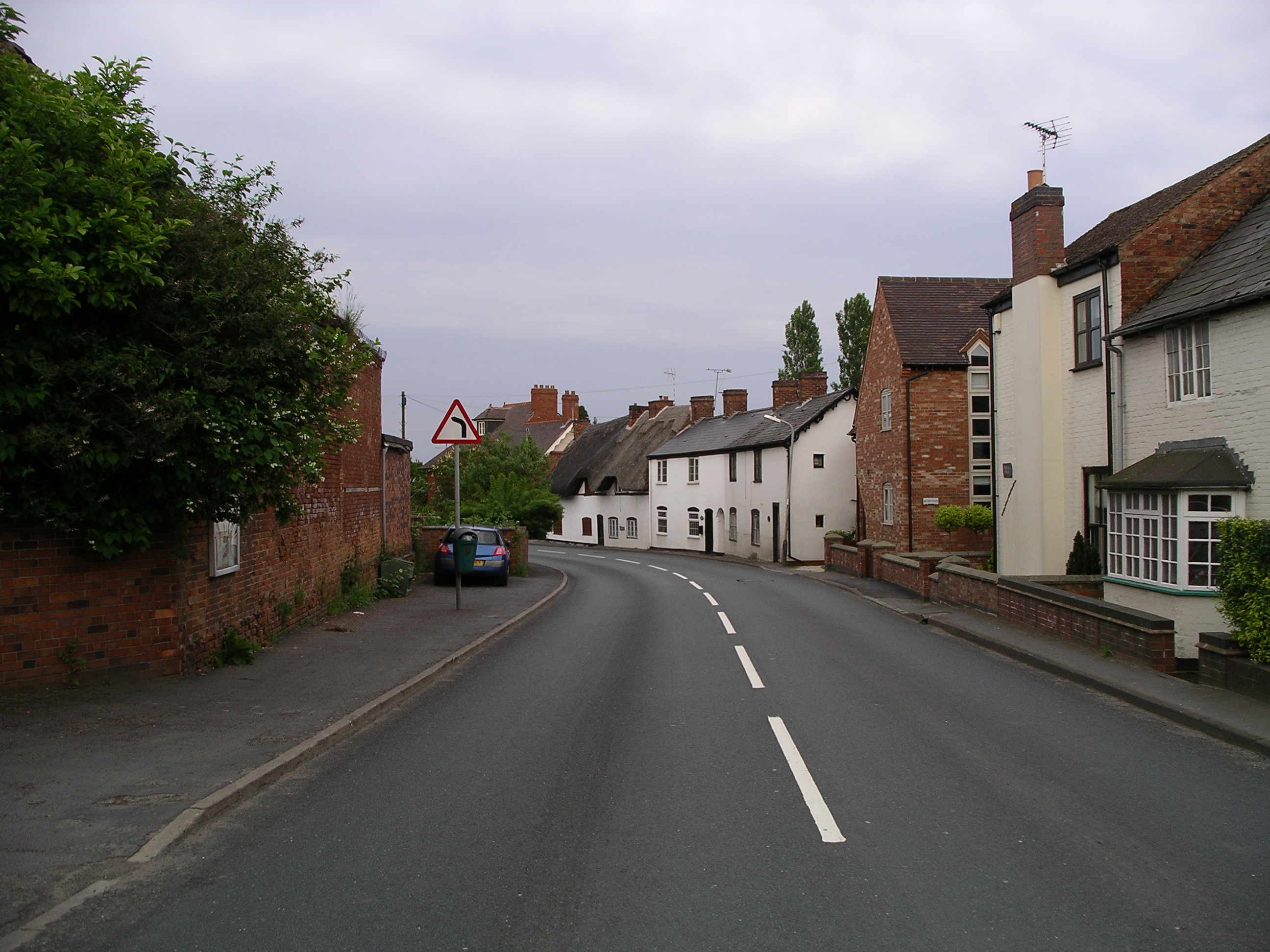
Ansty -Warwickshire -main road -6j08.jpg - Snowmanradio~commonswiki

WCML near Ansty.jpg - File Upload Bot (Magnus Manske)

Binley Woods, near Coventry - geograph.org.uk - 29351.jpg - GeographBot

Ansty - geograph.org.uk - 135530.jpg - GeographBot

Coombe Country Park - geograph.org.uk - 135524.jpg - GeographBot

Batleys Cash and Carry, Cross Point Business Park - geograph.org.uk - 172382.jpg - GeographBot

Cross Point Tesco Extra - geograph.org.uk - 172376.jpg - GeographBot

Showcase Cinema, Cross Point Business Park - geograph.org.uk - 172369.jpg - GeographBot

M69 - M6 Junction - geograph.org.uk - 200081.jpg - GeographBot

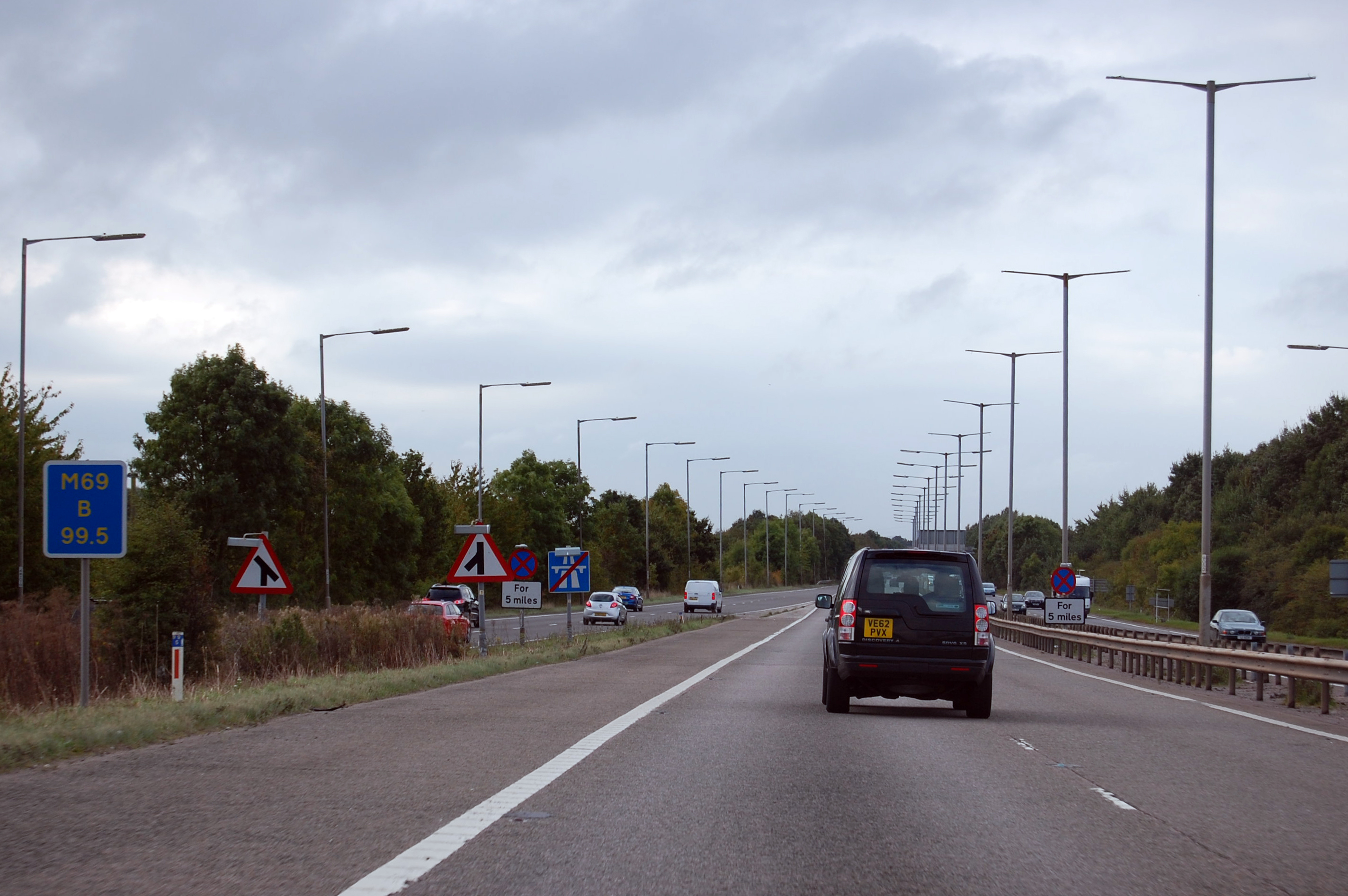
M69 at Ansty - geograph.org.uk - 201510.jpg - GeographBot

Mobile phone base station at Ansty - geograph.org.uk - 201534.jpg - GeographBot

Pines at the edge of Wrautum Field - geograph.org.uk - 284618.jpg - GeographBot

Weir on the Smite Brook - geograph.org.uk - 284625.jpg - GeographBot

Wrautum - geograph.org.uk - 284621.jpg - GeographBot

Coombe Abbey hotel - geograph.org.uk - 290218.jpg - GeographBot

Statue at Coombe - geograph.org.uk - 290220.jpg - GeographBot

Bird of prey, Coombe Park - geograph.org.uk - 378216.jpg - GeographBot

By the Wrautum, Coombe Park - geograph.org.uk - 378262.jpg - GeographBot

Reflections, Oxford canal near Ansty - geograph.org.uk - 444324.jpg - GeographBot

M6 approaching junction 2 - geograph.org.uk - 554756.jpg - GeographBot

M6 motorway - geograph.org.uk - 554758.jpg - GeographBot

M6 roadsign - geograph.org.uk - 554749.jpg - GeographBot

Ansty Hall Hotel - geograph.org.uk - 568715.jpg - GeographBot

Ansty Hall hotel entrance barrier - geograph.org.uk - 568713.jpg - GeographBot

Motorway loop - geograph.org.uk - 568711.jpg - GeographBot

Entrance to Nettle Hill training and conference centre - geograph.org.uk - 661522.jpg - GeographBot

M6 motorway bridge - geograph.org.uk - 661520.jpg - GeographBot

Alphabet Lodge Ansty - geograph.org.uk - 768427.jpg - GeographBot

Gas installation, Coventry - geograph.org.uk - 1748226.jpg - GeographBot

M6 Motorway - Junction 2 bridges - geograph.org.uk - 1818380.jpg - GeographBot

M6 Motorway at junction 2 - geograph.org.uk - 1818383.jpg - GeographBot

M6 motorway beyond junction 2 - geograph.org.uk - 1818386.jpg - GeographBot

M6 Motorway approaching Crowner Fields Farm bridge - geograph.org.uk - 1818389.jpg - GeographBot

M6 Motorway near Crowner Fields Farm - geograph.org.uk - 1818391.jpg - GeographBot

Home Farm - geograph.org.uk - 1963376.jpg - GeographBot

Main Road Bridge - geograph.org.uk - 1963389.jpg - GeographBot

Crowner Fields - geograph.org.uk - 1965248.jpg - GeographBot

Ansty Club - geograph.org.uk - 1965651.jpg - GeographBot

Ansty-Derelict Farm - geograph.org.uk - 1965655.jpg - GeographBot

Ansty-Main Road - geograph.org.uk - 1965659.jpg - GeographBot

View towards Nettle Hill - geograph.org.uk - 2039887.jpg - GeographBot

Approaching M6 junction 2 southbound - geograph.org.uk - 2071227.jpg - GeographBot

M6 motorway at junction 2 - geograph.org.uk - 2071238.jpg - GeographBot

Virgin Class 87 Passes Grand Union Canal at Ansty.jpg - Oxyman

A Virgin West Coast Class 87 hurries a north-bound express from Euston alongside the Grand Union Canal at Ansty, Warwickshire.jpg - Oxyman

Sunrise at Ansty Hall Hotel - geograph.org.uk - 2200427.jpg - GeographBot

Grazing land by the West Coast Main Line - geograph.org.uk - 2228611.jpg - GeographBot

Snow covered countryside near Hopsford Hall - geograph.org.uk - 2228614.jpg - GeographBot

Slip road from M6 southbound to M69 - geograph.org.uk - 2413279.jpg - GeographBot

Pylon in fields north of M6 motorway - geograph.org.uk - 2413323.jpg - GeographBot

Exit slip road from M6 northbound at Junction 2 - geograph.org.uk - 2439320.jpg - GeographBot

Farmland by the West Coast Main Line - geograph.org.uk - 2842075.jpg - GeographBot

Car park at Ansty Hall hotel - geograph.org.uk - 3141336.jpg - GeographBot

Oxford Canal, Bridge Number 15, Allcotts Bridge (demolished) - geograph.org.uk - 3151728.jpg - GeographBot

Oxford Canal, Hopsford Aqueduct - geograph.org.uk - 3153000.jpg - GeographBot

M69 crossing the Oxford Canal - geograph.org.uk - 3588143.jpg - GeographBot

M69 motorway near Ansty - geograph.org.uk - 3588145.jpg - GeographBot

M69 motorway, directional signs at (M6) junction 2 - geograph.org.uk - 3588146.jpg - GeographBot

View from the WCML - geograph.org.uk - 3651887.jpg - GeographBot

M6, Exit Sliproad at Junction 2 - geograph.org.uk - 3665058.jpg - GeographBot

Junction 2, Southbound M6 - geograph.org.uk - 3677758.jpg - GeographBot

M6-M69 Interchange - geograph.org.uk - 3677773.jpg - GeographBot

M6 Motorway - geograph.org.uk - 3677775.jpg - GeographBot

The A46 at the M69 - geograph.org.uk - 3792271.jpg - GeographBot

The M69 Northbound - geograph.org.uk - 3792278.jpg - GeographBot

The M69 Northbound - geograph.org.uk - 3792280.jpg - GeographBot

Ansty Hall - geograph.org.uk - 3847479.jpg - GeographBot

Hopsford Hall Farm - geograph.org.uk - 3856550.jpg - GeographBot

Hopsford Viaduct - geograph.org.uk - 3976813.jpg - GeographBot

Ansty Hall Hotel - geograph.org.uk - 3976823.jpg - GeographBot

Road junction - geograph.org.uk - 4063610.jpg - GeographBot

Road into Coventry - geograph.org.uk - 4064467.jpg - GeographBot

Virgin Pendolino train on the West Coast Main Line - geograph.org.uk - 4178453.jpg - GeographBot

Hopsford Viaduct and the Oxford Canal - geograph.org.uk - 4178496.jpg - GeographBot

Ansty Golf Club - geograph.org.uk - 4178671.jpg - GeographBot

Graffiti underneath Squires Bridge - geograph.org.uk - 4179573.jpg - GeographBot

Ploughed field next to the Oxford Canal - geograph.org.uk - 4179582.jpg - GeographBot

B4065 Main Road in Ansty - geograph.org.uk - 4179655.jpg - GeographBot

Hinckley Road crossing the M69 motorway - geograph.org.uk - 4179677.jpg - GeographBot

The southern end of the M69 motorway - geograph.org.uk - 4179692.jpg - GeographBot

Looking north along the M69 motorway - geograph.org.uk - 4179735.jpg - GeographBot

Rose ^ Castle in Ansty - geograph.org.uk - 4179741.jpg - GeographBot

The Main Road in Ansty - geograph.org.uk - 4179750.jpg - GeographBot

Entrance to Ansty Hall Hotel - geograph.org.uk - 4180825.jpg - GeographBot

Helicopter in front of Ansty Hall Hotel - geograph.org.uk - 4180845.jpg - GeographBot

North along the B4065 towards Shilton - geograph.org.uk - 4180871.jpg - GeographBot

Cottages in Ansty - geograph.org.uk - 4337133.jpg - GeographBot

The Rose and Castle - geograph.org.uk - 4337137.jpg - GeographBot

Pub Garden - geograph.org.uk - 4337143.jpg - GeographBot

Ansty - geograph.org.uk - 4337148.jpg - GeographBot

Waymarks - geograph.org.uk - 4339520.jpg - GeographBot

Sw of the West Coast Mainline - geograph.org.uk - 4363117.jpg - GeographBot

Canal overbridge at Ansty - geograph.org.uk - 4384867.jpg - GeographBot

M6 motorway at junction 2 - geograph.org.uk - 4455912.jpg - GeographBot

Farmland and bales - geograph.org.uk - 4468806.jpg - GeographBot

Farmland and bales near the Oxford Canal - geograph.org.uk - 4468833.jpg - GeographBot

Horses next to Noonhill Farm - geograph.org.uk - 4468921.jpg - GeographBot

M69 half mile to M6 junction - geograph.org.uk - 4592816.jpg - GeographBot

M69 slip road to M6 westbound - geograph.org.uk - 4593099.jpg - GeographBot

M6 west of Junction 2 westbound - geograph.org.uk - 4593104.jpg - GeographBot

M6 northbound at Junction 2 - geograph.org.uk - 4599720.jpg - GeographBot

Oxford Canal at Hopsford Aqueduct - geograph.org.uk - 4668009.jpg - GeographBot

Frozen canal at Ansty, 1981 - geograph.org.uk - 4789182.jpg - GeographBot

Farm buildings at Ansty, 1981 - geograph.org.uk - 4789202.jpg - GeographBot

Frozen canal at Ansty, 1981 - geograph.org.uk - 4789229.jpg - GeographBot

The Row, Ansty, 1981 - geograph.org.uk - 4789237.jpg - GeographBot

Ansty Golf Course - geograph.org.uk - 4848982.jpg - GeographBot

Countryside by the WCML - geograph.org.uk - 4902602.jpg - GeographBot
M69 joins the A46 - geograph.org.uk - 5156892.jpg - GeographBot

Rail and canal - geograph.org.uk - 5176560.jpg - GeographBot

Ansty Golf Course - geograph.org.uk - 5177623.jpg - GeographBot

Noonhill Farm - geograph.org.uk - 5177660.jpg - GeographBot

Young crop field, Crowner Fields - geograph.org.uk - 5219241.jpg - GeographBot

B4029 towards Shilton - geograph.org.uk - 5219248.jpg - GeographBot

Crop field near Ansty - geograph.org.uk - 5219249.jpg - GeographBot

Heading north west on the B4029 - geograph.org.uk - 5219251.jpg - GeographBot

Houses on Main Road, Ansty - geograph.org.uk - 5219257.jpg - GeographBot

Ansty Golf Centre - geograph.org.uk - 5282159.jpg - GeographBot

B4029 near Ansty - geograph.org.uk - 5282162.jpg - GeographBot

M69 motorway - geograph.org.uk - 5302983.jpg - GeographBot

A minor traffic jam - geograph.org.uk - 5554620.jpg - GeographBot

Arable farmland west of Ansty in Warwickshire - geograph.org.uk - 5723073.jpg - GeographBot

Canalside gardens in Ansty, Warwickshire - geograph.org.uk - 5723081.jpg - GeographBot

Canalside gardens in Ansty, Warwickshire - geograph.org.uk - 5723084.jpg - GeographBot

Canalside beer garden in Ansty, Warwickshire - geograph.org.uk - 5723087.jpg - GeographBot

Crop fields by the Oxford Canal near Ansty, Warwickshire - geograph.org.uk - 5723111.jpg - GeographBot

Kenilworth from the air - geograph.org.uk - 5835517.jpg - GeographBot

Railway crossing Oxford Canal near Shilton, aerial 2018 - geograph.org.uk - 5845966.jpg - GeographBot

Fields to the south of Oxford canal - geograph.org.uk - 6287611.jpg - GeographBot

Brookfield Farm - geograph.org.uk - 6289285.jpg - GeographBot

Grove Road, Ansty - geograph.org.uk - 6291015.jpg - GeographBot

Grove Road, Ansty - geograph.org.uk - 6291017.jpg - GeographBot
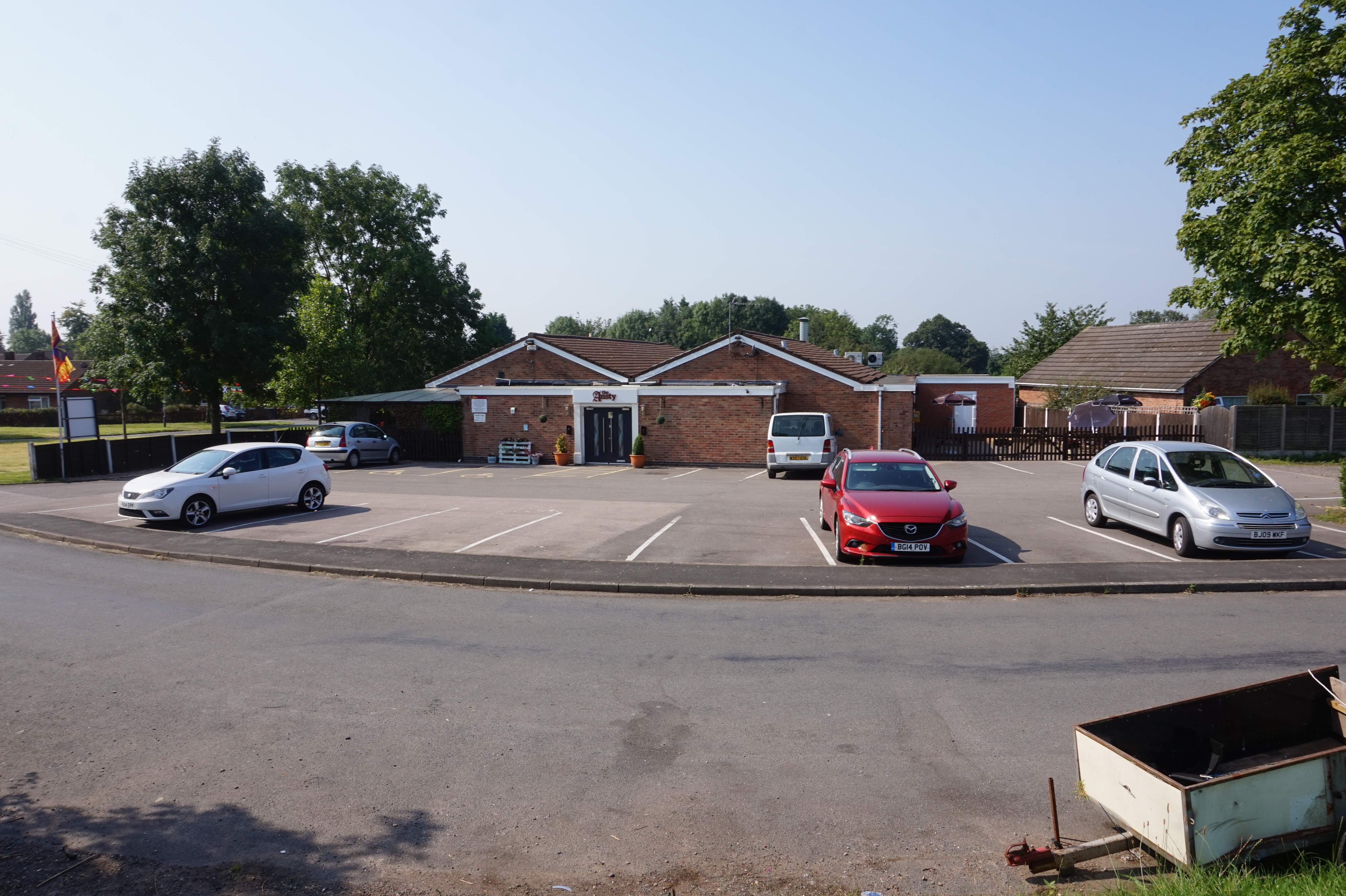
Ansty Club, Ansty - geograph.org.uk - 6291097.jpg - GeographBot

Paynes Cottage near bridge 14, Oxford Canal - geograph.org.uk - 6291113.jpg - GeographBot

Oxford canal at former Bridge ^15 - geograph.org.uk - 6291140.jpg - GeographBot

Tee 16 at Ansty Golf Course - geograph.org.uk - 6291168.jpg - GeographBot

Coventry Way joins the Oxford Canal - geograph.org.uk - 6291301.jpg - GeographBot

Oxford Canal-Centenary Way - geograph.org.uk - 6325581.jpg - GeographBot

Outside the Ansty Club - geograph.org.uk - 6381692.jpg - GeographBot

The Rose and Castle, Ansty - geograph.org.uk - 6381708.jpg - GeographBot

Telephone Box - Main Road, Ansty - geograph.org.uk - 6381714.jpg - GeographBot

The Row, Ansty - geograph.org.uk - 6381716.jpg - GeographBot

Hopsford Hall Farm - geograph.org.uk - 6489239.jpg - GeographBot

Mast by West Coast Main Line - geograph.org.uk - 7186204.jpg - GeographBot

Sign Gantry at the Start of the M69 Motorway - geograph.org.uk - 7846446.jpg - GeographBot

M69 near Ansty - geograph.org.uk - 7846449.jpg - GeographBot

Sign Gantry on the Southbound M69 near Ansty - geograph.org.uk - 7846452.jpg - GeographBot

M6 junction 2, off slip road to A46 and M69 - geograph.org.uk - 7865579.jpg - GeographBot

M69 bridge over slip road from M6 westbound, M6 junction 2 - geograph.org.uk - 7865581.jpg - GeographBot