Wikimedi'Òc
Modes d'emploi

Cet album fait partie des albums
Cet album photos contient les sous-albums suivants :


Trinidad como parte de Venezuela en 1699 (cropped).png - Warairarepano&Guaicaipuro

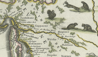
Blaeu - Nova Belgica et Anglia Nova (Detail Hudson Area).png - Frank Schulenburg

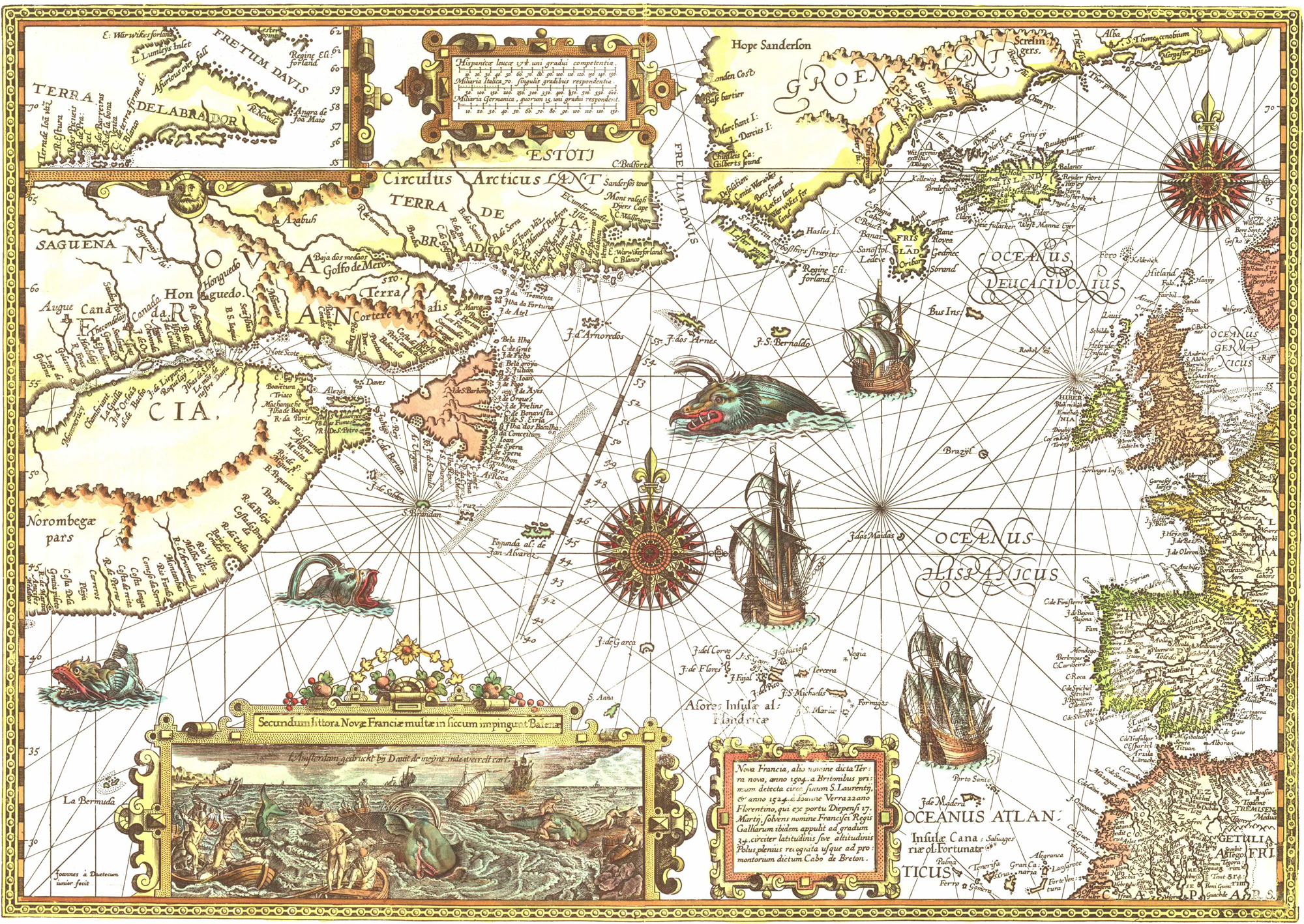
Blaeu - Nova Belgica et Anglia Nova.png - Jdx

Scott-anaconda.jpg - AnonMoos

Java indo 1595 map 01 gnangarra.jpg - Gnangarra

Carta Marina AB stitched.jpg - Jeff Dahl
1592 4 Nova Doetecum mr.jpg - Joopr

Zee Custen tusschen Dovere ende.jpg - Joopr

Detail (south) ebstorf world map.jpg - Ziko

1562 Americæ Gutiérrez.JPG - Kaldari

Orcades Carta Marina.JPG - MacRusgail

Olaus Magnus - On Rocks Decorated with Helmets.jpg - Holt
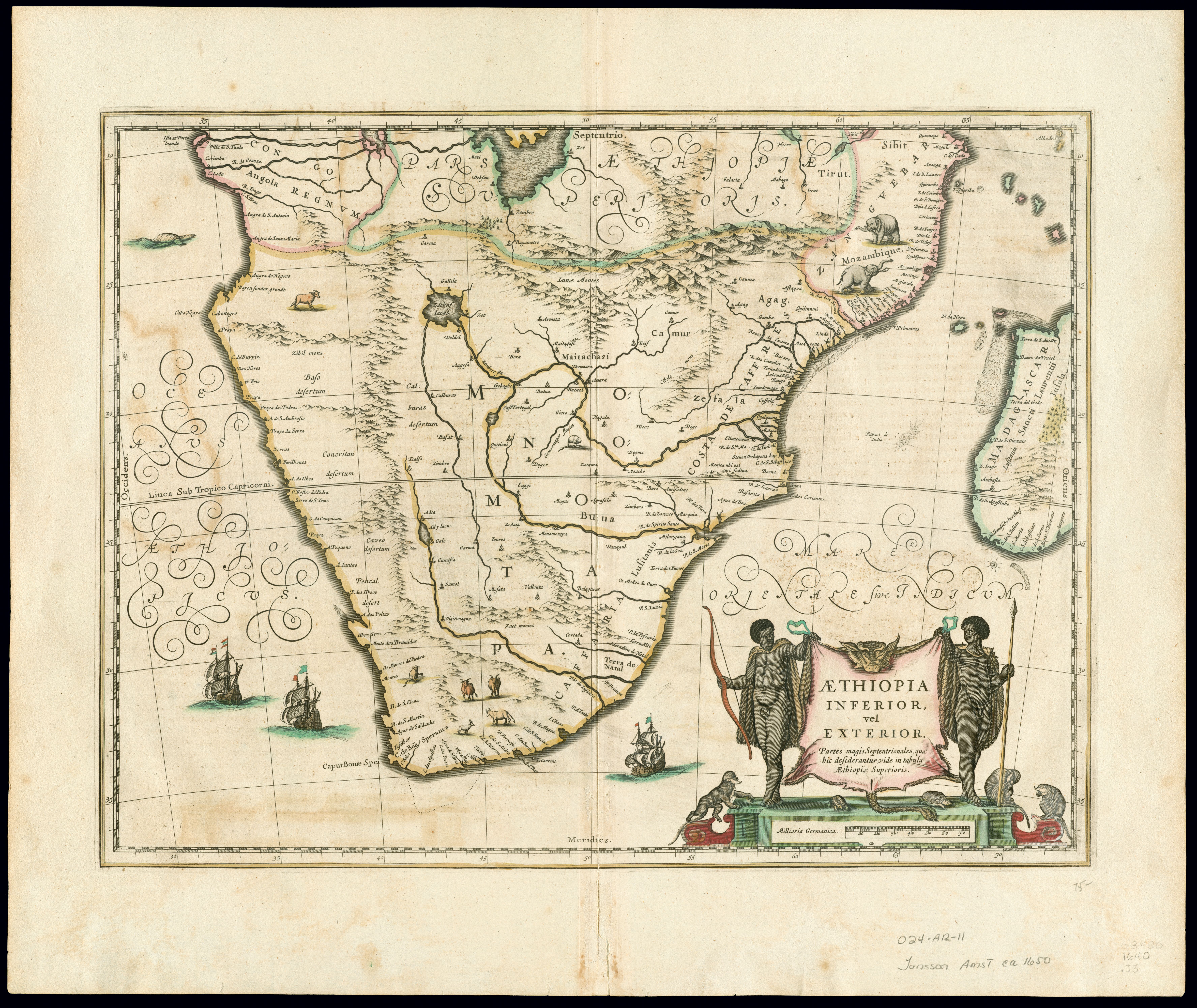
Southern Africa 1640, Jan Jansson (4265384-recto).jpg - Martin H.
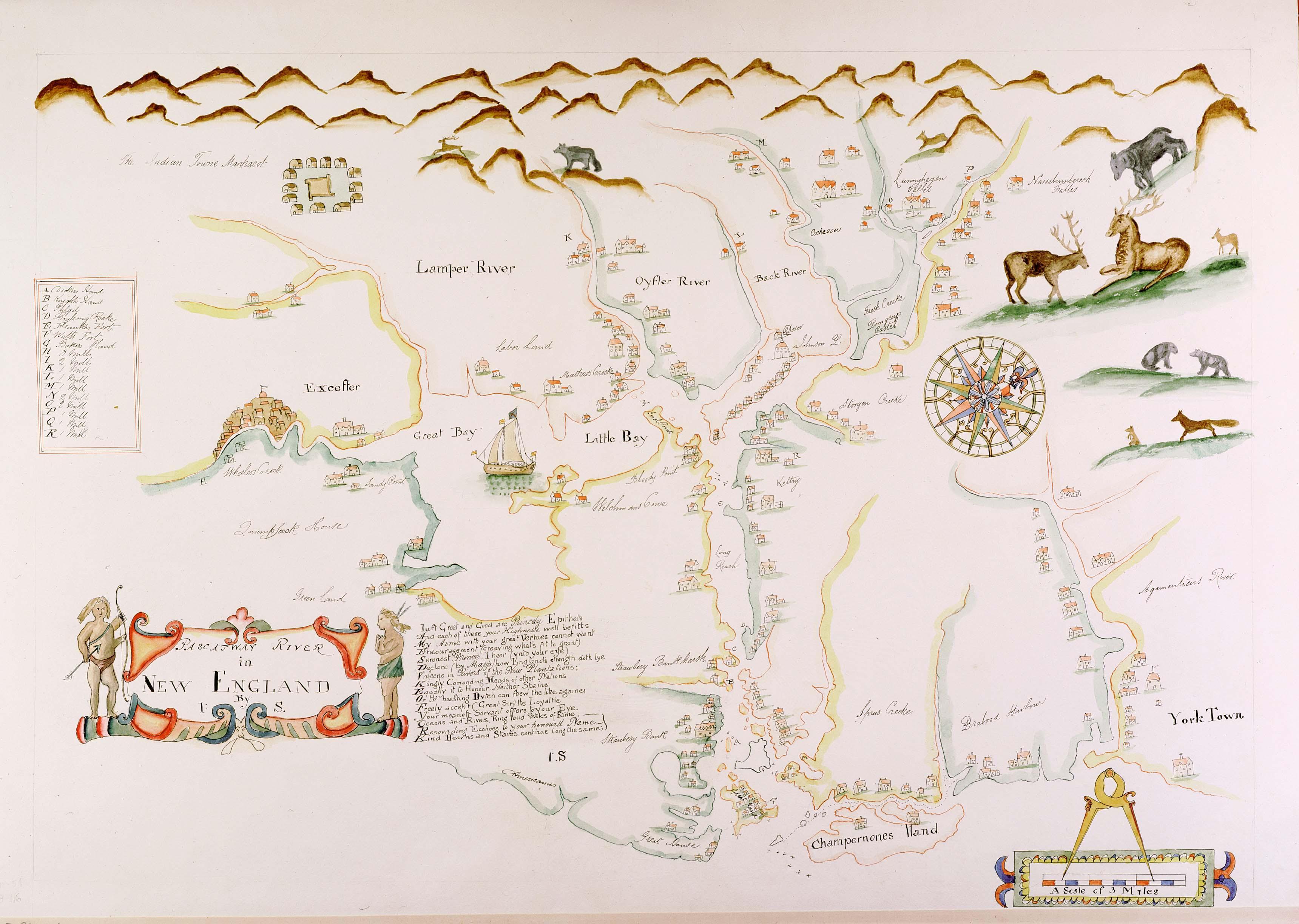
Pascatway River New England.jpg - Justass

Map - American Folk Art Museum, NYC - IMG 5867.JPG - Daderot

Jan Janssonius - Japan.jpg - Jan Arkesteijn

Deliniantur in hac tabula.E.jpg - Geagea

1847 Levasseur Map of Dept. Maine et Loire, France - Geographicus - MaineLoire-levasseur-1847.jpg - BotMultichill

1847 Levasseur Map of the Dept. Du Lot, France - Geographicus - Lot-levasseur-1847.jpg - BotMultichill
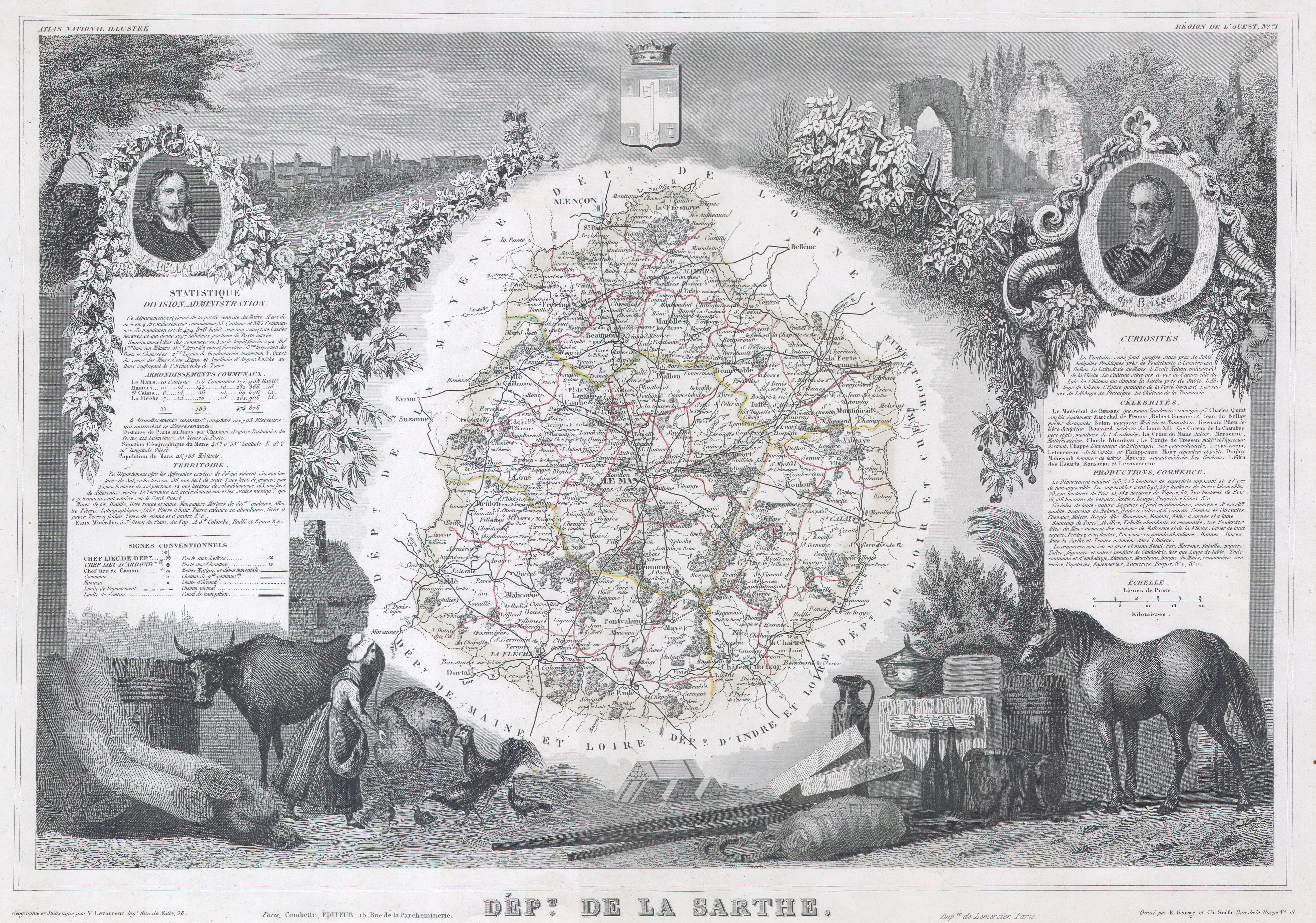
1847 Levasseur Map of Sarthe, France - Geographicus - Sarthe-levasseur-1847.jpg - BotMultichill

1657 Jansson Map of Germany (Germania) - Geographicus - Germaniae-jansson-1657.jpg - BotMultichillT

1852 Levasseur Map of Asia - Geographicus - Asia-levasseur-1852.jpg - BotMultichillT

1852 Levasseur Map of the Department Ariege, France (Bethmale, Bamalous, Moulis and Rogallai cheese - Geographicus - Ariege-levasseur-1852.jpg - BotMultichillT

1852 Levasseur Map of the Department Correze, France (Straw Wine Region) - Geographicus - Correze-levasseur-1852.jpg - BotMultichillT
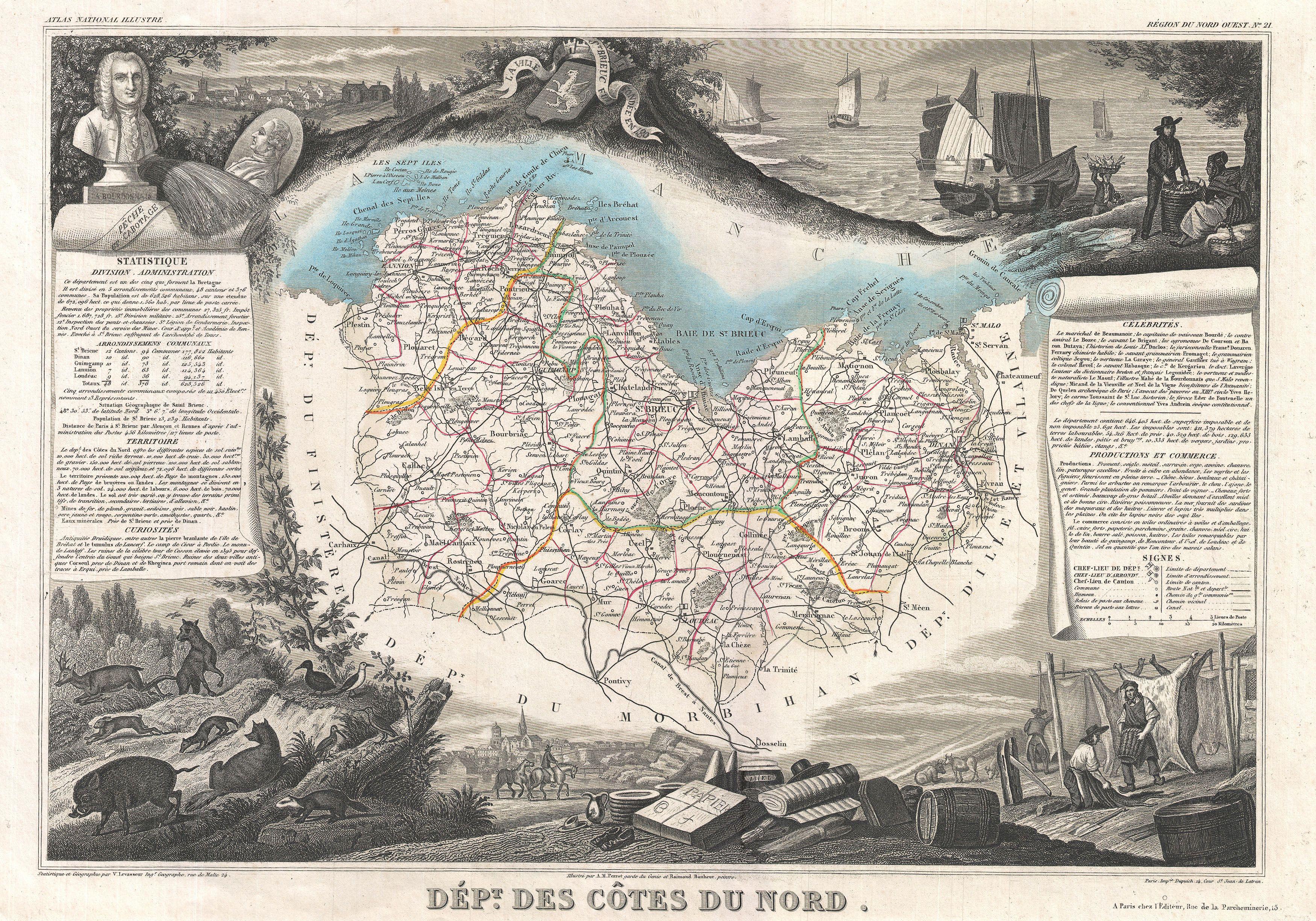
1852 Levasseur Map of the Department Cotes Du Nord, Brittany, France - Geographicus - CotesDuNord-levasseur-1852.jpg - BotMultichillT

1852 Levasseur Map of Seine-et-Oise (Paris) - Geographicus - SeineEtOise-levasseur-1852.jpg - BotMultichillT

1852 Levasseur Map of the Department D'Eure Et Loir, France (Loire Wine Region) - Geographicus - EureEtLoir-levasseur-1852.jpg - BotMultichillT

1852 Levasseur Map of the Department De Pas de Calais, France (Maroilles Cheese Region) - Geographicus - Calais-levasseur-1852.jpg - BotMultichillT

1670 Ogilby Map of West Africa ( Gold Coast, Slave Coast, Ivory Coast ) - Geographicus - Guinea-ogilby-1670.jpg - BotMultichillT
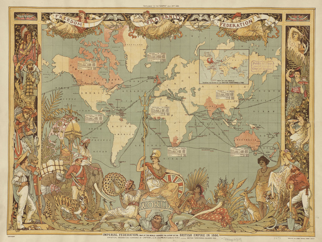
Imperial Federation, map of the world showing the extent of the British Empire in 1886.jpg - AnonMoos

Leguat Settlement.jpg - FunkMonk

Imperial Federation, map of the world showing the extent of the British Empire in 1886 - Norman B. Leventhal Map Center at the BPL.jpg - Dzlinker
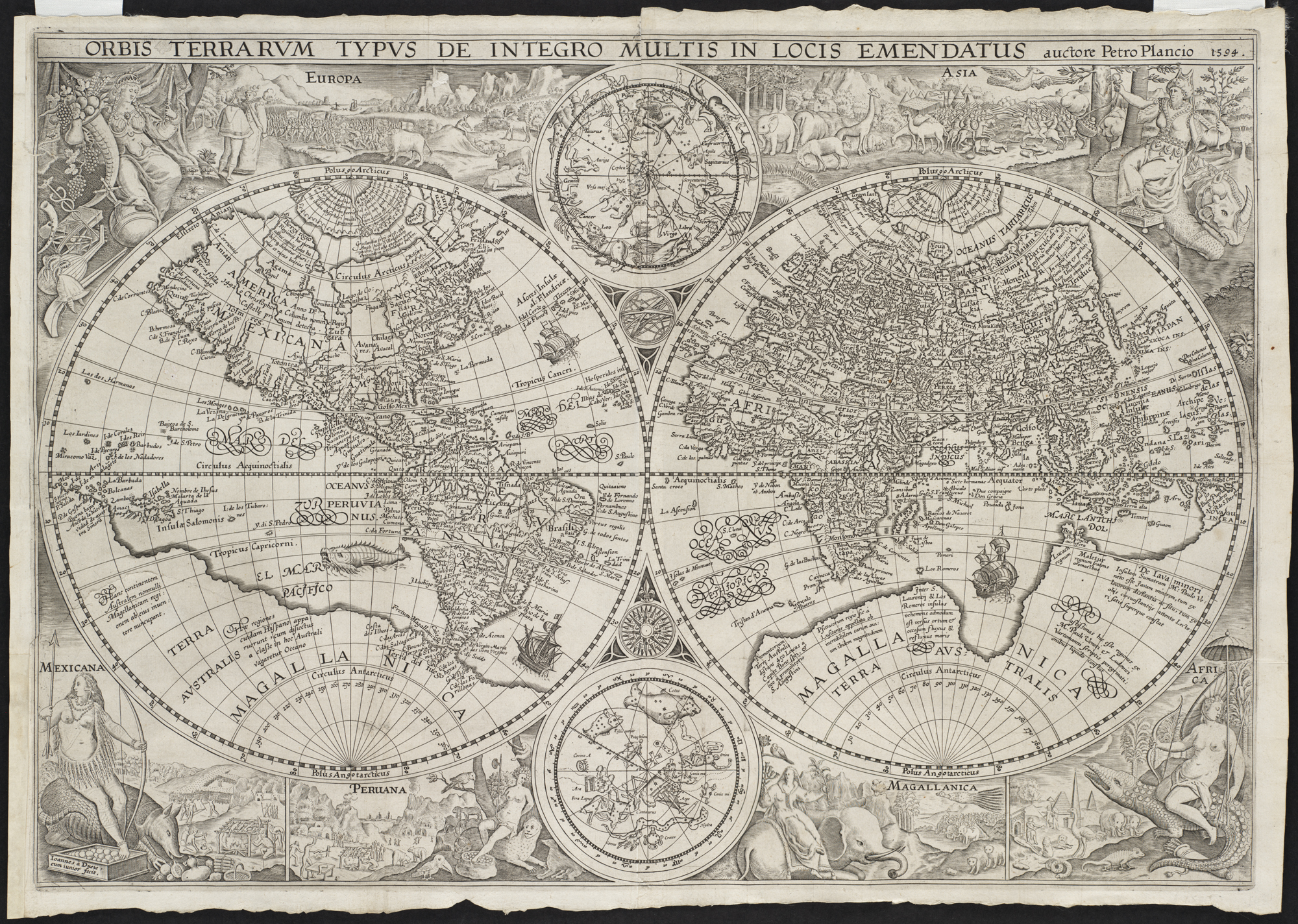
Orbis terrarum typus de integro multis in locis emendatus - Norman B. Leventhal Map Center at the BPL.jpg - Dzlinker

Rodrigues.jpg - FunkMonk

Het Aards Paradijs (2901353681).jpg - File Upload Bot (Magnus Manske)

Nova et accvrata Iaponiae, terrae Esonis ac insularum adjacentium ex novissima detectione descriptio (8342747633).jpg - File Upload Bot (Magnus Manske)

Venezuela with the Southern Part of New Andalusia WDL11337.png - Fæ

New Map of the Wonderful, Large and Rich Land of Guiana... WDL165.png - Fæ

This (is being produced) so that all can know the route of the travels (of the Israelites) 40 years in the desert (through) the width and length of the Holy Land from the Nile to the city of Damascus, WDL2887.png - Fæ
A Drawing (with a Western Perspective) of the East Indies from the Promontory of Good Hope to Cape Comorin WDL2915.png - Fæ

Judaea or the Holy Land, Here Divided into the Twelve Tribes of the Hebrews or Israelites WDL409.png - Fæ

A New Depiction of the Whole of Hungary WDL6761.png - Fæ
America Septentrionalis. NYPL434086.tiff - Fæ
A map of New England and New York - F. Lamb sculp. NYPL434826.tiff - Fæ

Piri Reis en proyección acimutal de Lambert con centro en el norte Mar Rojo.svg - Gustavo Girardelli

Atlas Ortelius KB PPN369376781-085av-085br.jpg - HuskyBot

Atlas Van der Hagen-KW1049B13 052-REYS-KAERTE vande Ambassade der Nederlantse Oost Indise Compagnie door China aen den Grooten Tartersen CHAM ....jpeg - OlafJanssen

Atlas Van der Hagen-KW1049B13 046-FOKIEN IMPERII SINARVM PROVINCIA VNDECIMA.jpeg - OlafJanssen

Atlas Van der Hagen-KW1049B13 038-XENSI. IMPERII SINARVM PROVINCIA TERTIA.jpeg - OlafJanssen

Atlas Van der Hagen-KW1049B13 034-PECHELI SIVE PEKING IMPERII SINARVM PROVINCIA PRIMA.jpeg - OlafJanssen

Chickens neck.svg - Furfur
"Pecheli, sive Peking, imperii Sinarum provincia prima." (22263939511).jpg - Tm

"Fokien Imperii Sinarum provincia undecima." (22066426729).jpg - Tm

"Iunnan Imperii Sinarum provincia decimaquinta." (21630475324).jpg - Tm

"Xensi, Imperii Sinarum provincia Tertia. " (22240618482).jpg - Tm

Asia depicted in the form of Pegasus (with modern hand coloring) by Heinrich Bünting, c.1590 the Sea monster.jpg - Baddu676

Asia XII ceylon.jpg - Baddu676

Portuguese map of the Indian Ocean, Africa and Arabia.jpg - Sir Thiago

Belgii novi, angliæ novæ, et partis Virginiæ - novissima delineatio. LOC 96686642.jpg - Fæ

Novvs atlas Sinensis. LOC 2002625249-2.jpg - Fæ

Novvs atlas Sinensis. LOC 2002625249-5.jpg - Fæ
Novvs atlas Sinensis. LOC 2002625249-6.tif - Fæ

Novvs atlas Sinensis. LOC 2002625249-6.jpg - Fæ

Carta Hydrographica y Chorographica de la Yslas Filipinas MANILA, 1734.jpg - Obsidian Soul

Pecheli Sive Peking - Atlas Maior, vol 11, map 13 - Joan Blaeu, 1667 - BL 114.h(star).11.(13).jpg - JhealdBot

Xensi… - Atlas Maior, vol 11, map 15 - Joan Blaeu, 1667 - BL 114.h(star).11.(15).jpg - JhealdBot

Fokien - Atlas Maior, vol 11, map 23 - Joan Blaeu, 1667 - BL 114.h(star).11.(23).jpg - JhealdBot
Ivnnan - Atlas Maior, vol 11, map 27 - Joan Blaeu, 1667 - BL 114.h(star).11.(27).jpg - JhealdBot

Kaart van Nova Zembla, 1594, NG-1979-564-2.jpg - Enyavar

Kaartje van Kaap de Goede Hoop, 1595, RP-P-OB-80.230.jpg - Mr.Nostalgic

1882 satirical map - L'Europe animale - physiologie comique.jpg - Balkanique

1917 pictorial map of the world - Tableau Demonstratif de L'Origine des Principales Fourrures.jpg - Balkanique
Gerard Mercator's 1569 map of the world - Sheet 05.tif - Balkanique
Gerard Mercator's 1569 map of the world - Sheet 07.tif - Balkanique

1570 map of Asia Minor by Giacomo Gastaldi.jpg - Balkanique

Tab. XI Asiae, comprehendens Indiam extra Gangem.jpg - Balkanique
Tabula Asiae III by Gerardus Mercator.jpg - Balkanique
Grand voyages, Part VIII title page from Grand voyages (1596) by Theodor de Bry (1528-1598). Original from The New York Public Library. Digitally enhanced by rawpixel. (50623605596).jpg - Eyes Roger

Luke Foxe voyage account (North-West Fox, 1635) - 4 foldout map - 3 fox.png - Wikipetzi

Venezuela with the Southern Part of New Andalusia WDL11337.jpg - Aavindraa

Tabula Hydrographica, In qua Italiae, orae maritimae; Item Venetiae, Istriae, Dalmatiae, Slavoniae, Graeciae, et oraet maritimae Corfu, Chephaloniae, et adjacentium insuarlum.jpg - Balkanique

Afr. II tab. - btv1b531968799 (2 of 3).jpg - Gzen92Bot

Pecheli sive Peking imperii sinarum provincia prima - (tiré du P. Martini) - btv1b59630415.jpg - Gzen92Bot

Nova Belgica Et Anglia Nova - btv1b8595999k (1 of 2).jpg - Gzen92Bot

Aethiopia inferior, vel exterior, partes magis septentrionales, quae hic desiderantur, vide in tabula Aethiopiae superioris - (Joan Blaeu) - btv1b531432316.jpg - Gzen92Bot

Typus orbis terrarum - Arnoldus F. ab Langren, auth. et scalp. - btv1b8490572r.jpg - Gzen92Bot

Fokien imperii sinarum provincia undecima - (tiré du P. Martini) ; excud. Ioannes Blaeu - btv1b5963074j.jpg - Gzen92Bot

Xensi imperii sinarum provincia tertia - (tiré du P. Martini) ; excudebat Ioannes Blaeu - btv1b5963053c.jpg - Gzen92Bot

Iunnan imperii sinarum provincia decimaquinta - (tirée du P. Martini) ; exc. Jo. Blaeu - btv1b5963095q.jpg - Gzen92Bot

Pecheli, sive Peking, Imperii Sinarum provincia prima, cum privilegio Sacrae Caesareae Majestatis & ordinum Belgicae Foederatae - btv1b525047297 (1 of 2).jpg - Gzen92Bot

Barbary Coast on 1644 Europa Recens by Blaeu (cropped).jpg - Enyavar

Figures on a 1644 Blaeu map of Europe.jpg - Enyavar

Cartouche in a Tartary map by Ortelius.jpg - Enyavar

Карта мира с древними животными.jpg - Aleksadiz
Portuguese map of the Indian Ocean, Africa and Arabia (cropped).jpg - HSLJN ZKRJNV

Nova Belgica Et Anglia Nova (New Netherland and New England) Blaeu Map c1634.jpg - Artanisen