Wikimedi'Òc
Modes d'emploi

Cet album fait partie des albums
Cet album photos contient les sous-albums suivants :


1855 Colton Map of the Arctic or North Pole - Geographicus - NorthernRegions-colton-1855.jpg - BotMultichill

1873 Colton Map of the Arctic or North Pole - Geographicus - PolarRegions-colton-1873.jpg - BotMultichillT
1872 Colton Map of the North Pole or Arctic - Geographicus - NorthPole-colton-1872.jpg - BotMultichillT

78 of 'Papers and Despatches relating to the Arctic Searching Expeditions of 1850-51-52. ... Collected and arranged by J. M. Second edition, with copious additions' (11038253456).jpg - Artix Kreiger 2

29 of 'La Mer Libre du Pole ... Traduit de l'Anglais et accompagné de notes ... par F. de Lanoye. Ouvrage illustré de 70 gravures, etc' (11085102446).jpg - FlickreviewR 2

Jeannette crew map.png - Davepape
Stielers Handatlas 1891 06.jpg - Kolossos

PSM V49 D338 Map of the unknown polar regions.jpg - Inductiveload

Térkép 1874-43.JPG - File Upload Bot (Magnus Manske)

'The English at the Noth Pole' by Riou and Montaut 067.jpg - Lau060680

'The English at the Noth Pole' by Riou and Montaut 068.jpg - Lau060680

1835 Murray Map of the Arctic Land Expedition (Hudson Bay, Canada) - Geographicus - ArcticExp-murray-1835.jpg - BotMultichill
1814 Thomson Map of the Northern Hemipshere ^ Arctic - Geographicus - NorthernHemipshere-thomson-1814.jpg - BotMultichill
1865 Hall Map of Frobisher Bay, Baffin Island, Canada (important Arctic Exploration Map) - Geographicus - FrobisherBay-hall-1865.jpg - BotMultichillT

1818 Pinkerton Map of the Northern Hemisphere ( North Pole, Arctic ) - Geographicus - NorthernHemisphere-pinkerton-1818.jpg - BotMultichillT

SCOTT1899 pg008.jpg - Metilsteiner

UEBERSICHTSKARTE DES ARCTISCHEN GEBIETES.jpg - Metilsteiner

Kart over Fridtjof Nansen's Polarexpedition 1893-1896 - no-nb krt 00913.jpg - SteinsplitterBot

Kart over Fridtjof Nansen's Polarexpedition 1893-189? - no-nb krt 00912.jpg - SteinsplitterBot
Skizze der Entdeckungen der englischen Polar-Expedition unter Nares, 1876 - UvA-BC OTM HB-KZL 31.02.36.tif - Spinster

BERKH(1821) p517.jpg - Metilsteiner

BERKH(1821) p515.jpg - Metilsteiner

A chart illustrative of the cruise of the American Arctic expedition in search of sir John Franklin in the years 1850 & 51 fitted out by Henry Gunnell - UvA-BC OTM HB-KZL 101.14.13.jpg - Spinster
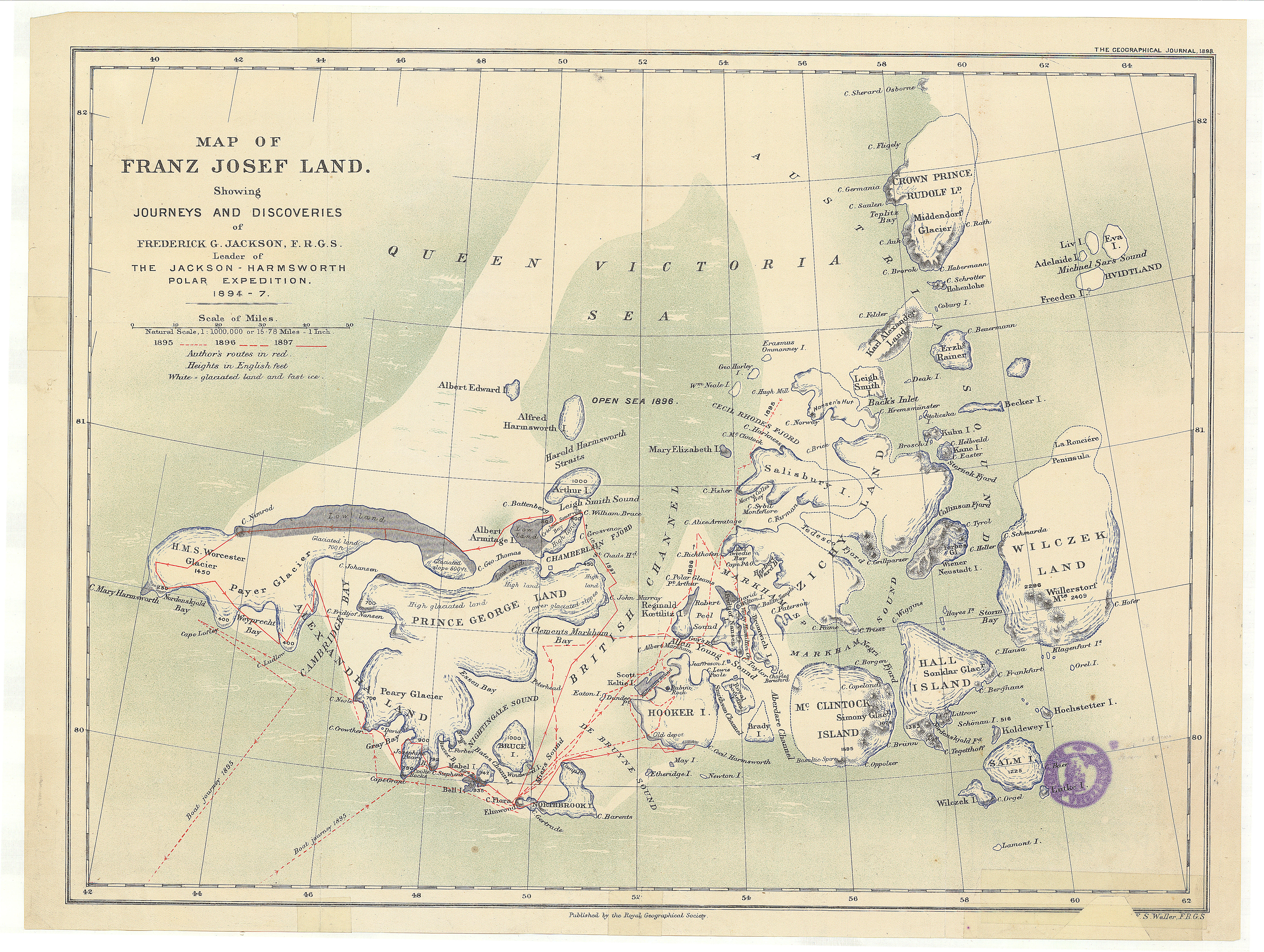
Map of Franz Josef Land showing journeys and discoveries of Frederick G. Jackson, F.R.G.S. - UvA-BC OTM HB-KZL 61 18 38.jpg - Spinster

Skizze der Entdeckungen der englischen Polar-Expedition unter Nares, 1876 - UvA-BC OTM HB-KZL 31 02 36.jpg - Spinster

Polar-Karte enthaltend- die Länder u. Meere vom Nord-Pol bis 50 N. Br. u. weiter, sowie Übersicht des Russischen Reichs (12973238293).jpg - Fæ

Arctic Regions and British America (12796647205).jpg - Fæ

Mohn Contour map of the North Ocean.jpg - Dreizung

The century dictionary and cyclopedia, a work of universal reference in all departments of knowledge with a new atlas of the world (1896) (14589767230).jpg - Fæ

The cruise of the Marchesa to Kamschatka and New Guinea - with notices of Formosa, Liu-Kiu, and various islands of the Malay archipelago (1886) (20525313348).jpg - SteinsplitterBot

An Outline to Shew the Connected Discoveries of Captains Ross, Parry, and Franklin in the Years 1818, 19, 20 and 21 (1823) (3752049533).jpg - Geo Swan

Payer Karte Franz Josef Land 1874.jpg - Dreizung

Discoveries in the Arctic Regions, Ross, 1834.jpg - Thincat

217 of 'Lettre écrites des régions polaires par lord Dufferin et traduites de l'anglais ... par F. de Lanoye. Ouvrage illustré de vingt-cinq vignettes sur bois et accompagné de trois cartes' (11060935604).jpg - FlickreviewR 2

35 of 'Géographie générale; physique, politique et économique. ... Avec ... cartes ... gravures, etc' (11113317213).jpg - Artix Kreiger 2

1067 of 'Géographie générale; physique, politique et économique. ... Avec ... cartes ... gravures, etc' (11113592813).jpg - Artix Kreiger 2
309 of 'Premiers voyages au pays des glaces. Par Charles Baye (or rather, translated by him from pp. 1-474 in the 1881 edition of Hellwald's “Im ewigen Eis.” Edited by François Ebhardt. With illustrations)' (11195405225).jpg - FlickreviewR 2

381 of 'The High School Manual of Geography. With maps and illustrations' (11281291434).jpg - Artix Kreiger 2

121 of 'Out with the Olde Voyagers' (11302841264).jpg - Artix Kreiger 2

94 of '(The Gallery of Geography, a pictorial and descriptive tour of the world.)' (11166340564).jpg - FlickreviewR 2

349 of 'The Great Frozen Sea. A personal narrative of the voyage of the “Alert” during the Arctic Expedition of 1875, 6' (11125446695).jpg - Artix Kreiger 2

61 of 'The History of the last Quarter-Century in the United States, 1870-1895 ... With ... illustrations' (11297093895).jpg - Artix Kreiger 2

69 of 'Les Grands voyageurs de notre siècle. Ouvrage contenant ... dessins ... et ... cartes, etc' (11202219026).jpg - Artix Kreiger 2

581 of 'Les Grands voyageurs de notre siècle. Ouvrage contenant ... dessins ... et ... cartes, etc' (11201065373).jpg - Artix Kreiger 2

596 of 'Les Grands voyageurs de notre siècle. Ouvrage contenant ... dessins ... et ... cartes, etc' (11201609993).jpg - Artix Kreiger 2

81 of 'Les Grands voyageurs de notre siècle. Ouvrage contenant ... dessins ... et ... cartes, etc' (11201056965).jpg - Artix Kreiger 2

688 of 'Les Grands voyageurs de notre siècle. Ouvrage contenant ... dessins ... et ... cartes, etc' (11200295424).jpg - Artix Kreiger 2

964 of '(Manual of Geology- treating of the principles of the science with special reference to American geological history ... Revised edition.)' (11233311283).jpg - Artix Kreiger 2

620 of 'Les Grands voyageurs de notre siècle. Ouvrage contenant ... dessins ... et ... cartes, etc' (11199603293).jpg - Artix Kreiger 2

Image taken from page 271 of 'Under Nordlysets Straaler. Skildringer fra Lappernes Land' (11180034284).jpg - Artix Kreiger 2

Image taken from page 215 of 'Die neuesten Entdeckungen in Afrika, Australien und der arktischen Polarwelt, etc' (11062043786).jpg - Artix Kreiger 2

581 of '(Fram over Polhavet.) In Nacht und Eis. Die Norwegische Polarexpedition, 1893-1896 ... Mit einem Beitrag von Kapitän Sverdrup, 207 Abbildungen (including portraits), 8 Chromotafeln und 4 Karten' (11242130546).jpg - Artix Kreiger 2

611 of '(Fram over Polhavet.) In Nacht und Eis. Die Norwegische Polarexpedition, 1893-1896 ... Mit einem Beitrag von Kapitän Sverdrup, 207 Abbildungen (including portraits), 8 Chromotafeln und 4 Karten' (11243050993).jpg - Artix Kreiger 2

Karta Si︠e︡vernago Ledovitago okeana v granit︠s︡akh Rossīĭskoĭ Imperīi - sostavlena na osnovanīi russkikh gidrograficheskikh izsli︠e︡dovanīĭ s 1734 po 1871 god LOC 92685396.jpg - Fæ

Nordenskiöld-Lettres-1880-carte du Passage Nord-Est.jpg - François GOGLINS

1828 British Arctic exploration map.jpg - SaltedSturgeon

Admiralty Chart No 260 North Polar Sea, Published 1855 3.jpg - Balkanique

Map of Canada's Arctic Archipelago, circa 1903.jpg - Geo Swan
Leigh Smith 1880 expedition map.tif - Kaschelott

Petermann Franz-Josef-Land, provisorische Karte 1874.png - Dreizung

Petermann Franz-Josef-Land, provisorische Skizze 1874.png - Dreizung

Le Tour du monde-12-p019.jpg - Bzhqc

Regions circumpolaires.jpg - Enyavar

Astronomical and Geographical Land Map of the Russian State.jpg - LlywelynII
Astronomical and Geographical Land Map of the Russian State.tif - LlywelynII

Admiralty Chart No 2282 Arctic Ocean and Greenland Sea, Published 1872.jpg - Kognos