Wikimedi'Òc
Modes d'emploi

Cet album fait partie des albums
Cet album photos contient les sous-albums suivants :


Charlestown - geograph.org.uk - 3508.jpg - GeographBot

Entrance to Polperro harbour, seen from the sea. - geograph.org.uk - 2448.jpg - GeographBot

Fowey Harbour - geograph.org.uk - 2967.jpg - GeographBot

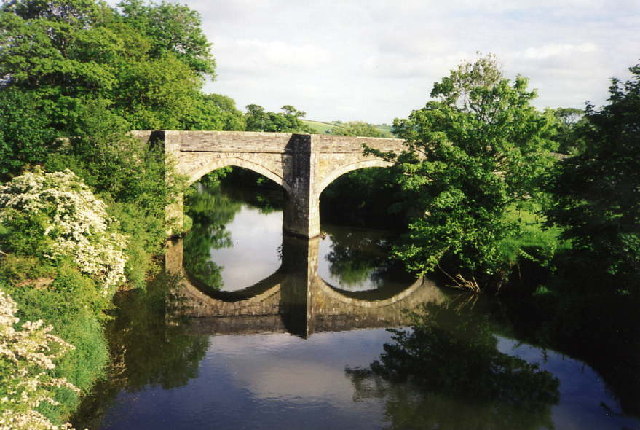
Bridge, Estuary and West Looe - geograph.org.uk - 10976.jpg - GeographBot

Hotel, Poldhu Point - geograph.org.uk - 2458.jpg - GeographBot

Mullion Cove - geograph.org.uk - 2455.jpg - GeographBot

Penzance pier. - geograph.org.uk - 2462.jpg - GeographBot

Reflections in Mevagissey Harbour - geograph.org.uk - 11005.jpg - GeographBot

"Trewannion" Lesnewth, Cornwall - geograph.org.uk - 72143.jpg - GeographBot

Caerthillian Cove. - geograph.org.uk - 42299.jpg - GeographBot

Lerryn - geograph.org.uk - 37547.jpg - GeographBot

Logan Rock, near Porthcurno - geograph.org.uk - 36013.jpg - GeographBot

Gew-graze - geograph.org.uk - 42300.jpg - GeographBot

Grazing, Predannack Head. - geograph.org.uk - 42301.jpg - GeographBot

Landewednack, Upper or Higher Mill, Poltesco - geograph.org.uk - 43212.jpg - GeographBot

Lesnewth, Tregrylls - geograph.org.uk - 49234.jpg - GeographBot
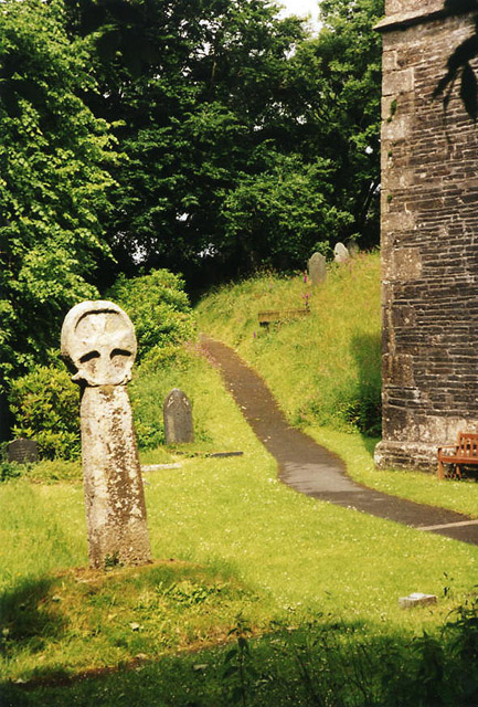
Lesnewth, churchyard cross - geograph.org.uk - 49231.jpg - GeographBot

Mary Tavy, old railway embankments - geograph.org.uk - 49245.jpg - GeographBot

Morvah, Portheras Valley - geograph.org.uk - 41214.jpg - GeographBot

St Agnes, Trevellas Porth - geograph.org.uk - 36345.jpg - GeographBot

Morvah, Lower Chypraze Farm - geograph.org.uk - 72126.jpg - GeographBot
St Stephens by Launceston, Higher New Bridge - geograph.org.uk - 37541.jpg - GeographBot

Pol Cornick - geograph.org.uk - 42302.jpg - GeographBot

Valley near Camelford - geograph.org.uk - 37186.jpg - GeographBot

St Agnes, Tywarnhayle Mill, Mount Hawke - geograph.org.uk - 41219.jpg - GeographBot

St Gennys, Trevigue - geograph.org.uk - 49235.jpg - GeographBot

St Teath, lane to Tregardock - geograph.org.uk - 72121.jpg - GeographBot

Cuby, Tregony - geograph.org.uk - 92309.jpg - GeographBot

Cuby, the Fal valley near Tregony - geograph.org.uk - 92308.jpg - GeographBot

St Dennis, derelict barns at Treviscoe Barton - geograph.org.uk - 88260.jpg - GeographBot

Paul, Mousehole harbour - geograph.org.uk - 108384.jpg - GeographBot

St Agnes, Wheal Kitty - geograph.org.uk - 92307.jpg - GeographBot

Portreath, inner harbour - geograph.org.uk - 108387.jpg - GeographBot

St Mabyn, St Mabyn's church and the St Mabyn Inn - geograph.org.uk - 95338.jpg - GeographBot

Cape Cornwall - geograph.org.uk - 216204.jpg - GeographBot

Penaligon Downs TV-Relay - geograph.org.uk - 310114.jpg - GeographBot

Newhouse Farm - geograph.org.uk - 322842.jpg - GeographBot

Aerial View of Scraesdon Fort and Antony - geograph.org.uk - 340331.jpg - GeographBot

St Michael's Mount - geograph.org.uk - 742583.jpg - GeographBot

Herodsfoot and Valley - geograph.org.uk - 780787.jpg - GeographBot

Spring Flowers on the way to Herodsfoot - geograph.org.uk - 780633.jpg - GeographBot

The View from Herodsfoot Church yard - geograph.org.uk - 780604.jpg - GeographBot

Cadgwith Cove, Cornwall - geograph.org.uk - 812892.jpg - GeographBot

Headland east of Cadgwith Cove - geograph.org.uk - 812887.jpg - GeographBot

The river, Truro in 1998 - geograph.org.uk - 869673.jpg - GeographBot

Down by the Fowey - geograph.org.uk - 875076.jpg - GeographBot

The clay empties for St Blazey - geograph.org.uk - 875060.jpg - GeographBot

The Manor House, Golden - scene of St Cuthbert's arrest - geograph.org.uk - 887858.jpg - GeographBot

A Favourite Perch - geograph.org.uk - 905407.jpg - GeographBot

Porthmeor Beach St Ives - geograph.org.uk - 905414.jpg - GeographBot

Truro Cathedral - geograph.org.uk - 905437.jpg - GeographBot

Hotel St Eia - geograph.org.uk - 1070277.jpg - GeographBot

Falmouth Bound - geograph.org.uk - 1593932.jpg - GeographBot
Penaligon Downs TV-Relay - geograph.org.uk - 310114 (cropped).jpg - Saga City

Sign for St Eia Hotel, Bistro Bar ^ Restraurant (sic) - geograph.org.uk - 2983297.jpg - GeographBot

Heliport with helicopter awaiting boarding passengers - geograph.org.uk - 3011428.jpg - GeographBot