Wikimedi'Òc
Modes d'emploi

Cet album fait partie des albums
Cet album photos contient les sous-albums suivants :


Map of Ancient Italy, Southern Part.jpg - Yuma

The Historical Atlas, 1911 – Distribution of Races in the Balkan Peninsula and Asia Minor.jpg - Beao
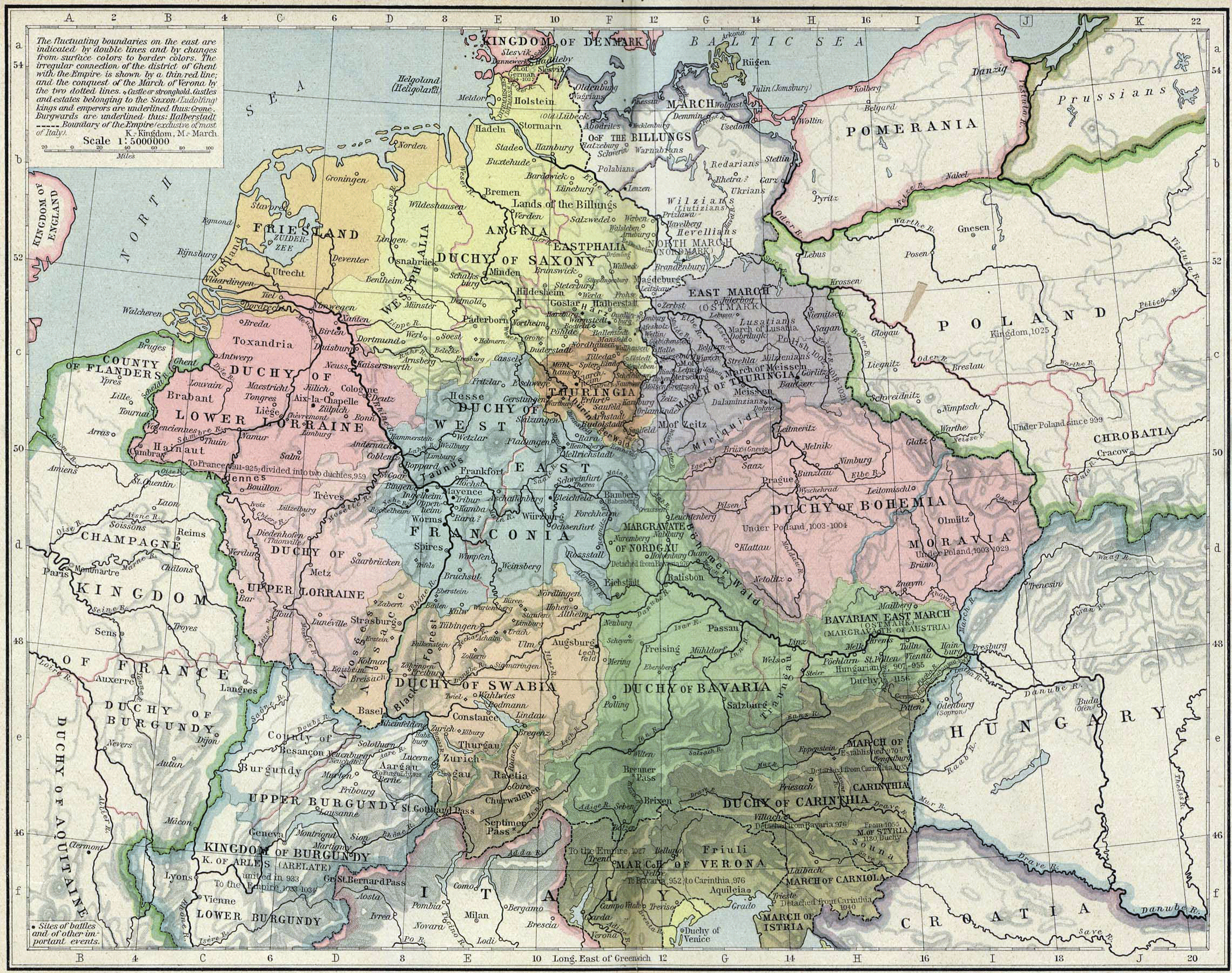
Central europe 919 1125.png - TUVOK~commonswiki

Central map1911.gif - Ohconfucius

EB1911 Africa Geology.JPG - BetacommandBot

RomanPowerAsiaMinor90BCE.JPG - Monsieurdl
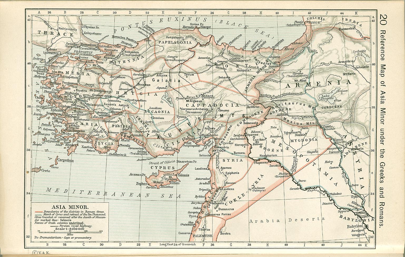
Shepherd-c-020.jpg - Shooke

España1212 a 1492.jpg - Fergon
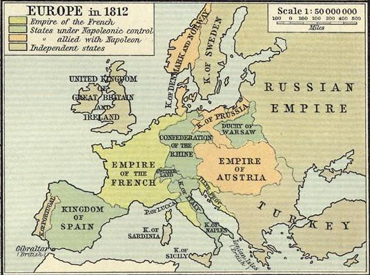
Europe in 1812.PNG - R'n'B

Plan of Yaroslavl, 1911.jpg - Berillium
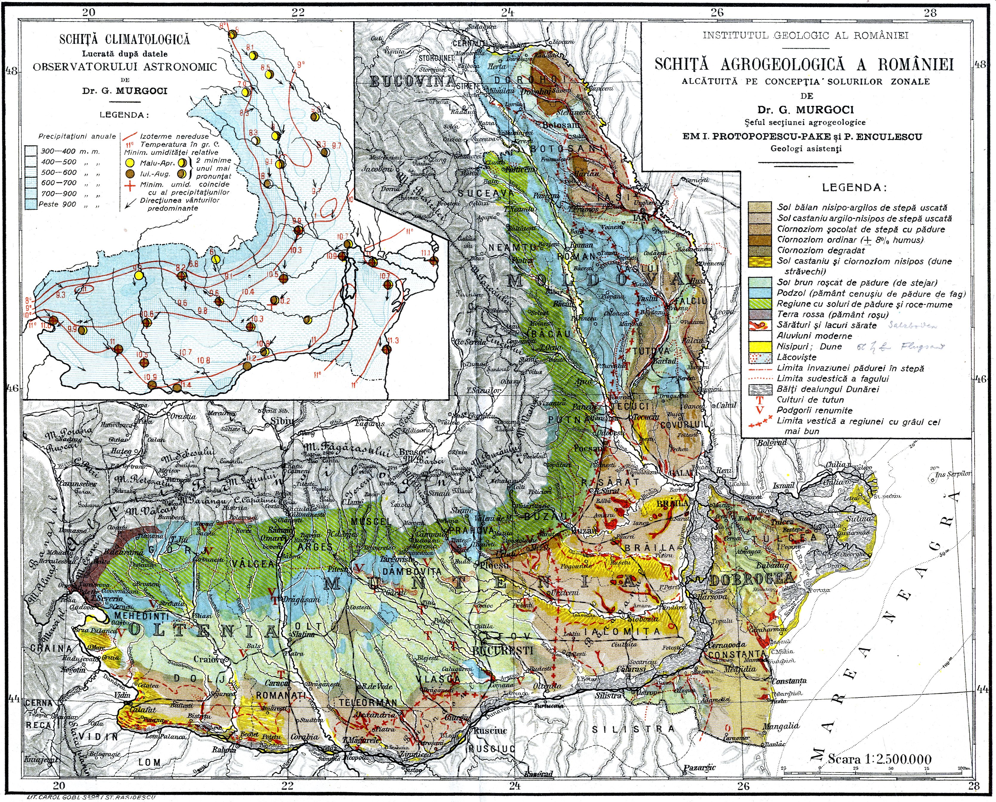
Romania - soluri si clima - Gheorghe Murgoci.JPG - Alex:D

Shepherd-c-020 cropped Armenia.jpg - Geagea
NikolaevskoyeAdmiralty.jpg - Dinamik

Ponce de leon amusement park 1911.jpg - Keizers

TK25 Sachsen Messtischblatt 49 Kötzschenbroda, Radebeul 1911.jpg - Niabot

Railway Ormskirk Skelm St Helens 1911 edited-4.jpg - RuthAS

1911 Tripoli map NGS.png - M2545

București, harta 1911, Serviciul Geografic al Armatei.jpg - Bogdan

Amrail.png - Blizko

Tour de France 1911 map-fr.svg - BaldBoris

United States contour map (8346581234).jpg - File Upload Bot (Magnus Manske)

United States base map (8345527299).jpg - File Upload Bot (Magnus Manske)

United States relief map (8345527223).jpg - File Upload Bot (Magnus Manske)

Map of Massachusetts showing state highways laid out & petitioned for (7537858042).jpg - File Upload Bot (Magnus Manske)

1911 map of proposed tunnel to East Boston.png - Pi.1415926535

Spezialkarte der Österreichisch-ungarischen Monarchie - Radmannsdorf 1911.jpg - Sporti
Spezialkarte der Österreichisch-ungarischen Monarchie - Gottschee und Tschernembl 1911.jpg - Sporti

Spezialkarte der Österreichisch-ungarischen Monarchie - Bischoflack und Idria 1911.jpg - Sporti

Spezialkarte der Österreichisch-ungarischen Monarchie - Eisenkappel und Kanker 1911.jpg - Sporti

Spezialkarte der Österreichisch-ungarischen Monarchie - Pettau und Vinica 1911.jpg - Sporti
Greatest New York (panoramic view) - H. Wellge, sk. NYPL1691404.tiff - Fæ
Jamaica Bay and Rockaway Inlet, Long Island, New York. NYPL1692356.tiff - Fæ
Sheet No. 13. (Includes Old Place, (Elizabeth Grove Road) Elizabeth Grove Avenue, (Arlington), Western Avenue.) NYPL1531725.tiff - Fæ
Sheet No. 19. (Includes Marks Creek, Prall's River and part of Bloomfield.) - Sheet No. 35. (Includes Chelsea and part of Prall's Island.) NYPL1531731.tiff - Fæ

1911 Tri-state Trolley Map.png - Pi.1415926535

Karte Nordostgrönland Koch 1911.png - Ratzer

EB1911 North Carolina.jpg - Library Guy

1911 Map of Kolkata West Bengal India.jpg - AmyNorth

EB1911 Porto Rico.jpg - Library Guy

EB1911 China.jpg - DivermanAU

Rainfall in England and Wales, 1911.jpg - Csemerick

Karachi map 1911.jpg - Nizil Shah

EB 1911 Ptolemy's Map.png - LlywelynII

EB 1911 Map Fig 4.png - LlywelynII

EB 1911 Map Fig 5.png - LlywelynII

EB 1911 Map Fig 7.png - LlywelynII
EB 1911 Map Fig 9.png - LlywelynII

EB 1911 Map Fig 10.png - LlywelynII

1911 EB Map Fig 11.png - LlywelynII

1911 EB Map Fig 12.png - LlywelynII

1911 EB Map Fig 13.png - LlywelynII
1911 EB Map Fig 16.png - LlywelynII

EB 1911 Map Fig 14.png - LlywelynII

EB 1911 Map Fig 18.png - LlywelynII

EB 1911 Map Fig 19.png - LlywelynII

Березкин Д.М. Библейский атлас. (1911). — Палестина во время земной жизни Иисуса Христа.jpg - Senapa

Révai nagy lexikona; az ismeretek enciklopédiája (1911) (14598111967).jpg - Fæ

Révai nagy lexikona; az ismeretek enciklopédiája (1911) (14781483181).jpg - Fæ

Révai nagy lexikona; az ismeretek enciklopédiája (1911) (14781481831).jpg - Fæ

An Australian bird book - a pocket book for field use (1911) (19727029934).jpg - SteinsplitterBot

Bulletin of the Geological Society of America (1911) (20261763940).jpg - SteinsplitterBot

Clare Island survey (1911) (20628420546).jpg - SteinsplitterBot

Révai nagy lexikona; az ismeretek enciklopédiája (1911) (14597983978).jpg - Fæ

The Commercial and financial chronicle (1911) (14778989871).jpg - SteinsplitterBot

The Commercial and financial chronicle (1911) (14779623474).jpg - SteinsplitterBot

Austria-Hungary - with excursions to Cetinje, Belgrade, and Bucharest - handbook for travellers (1911) (14776742434).jpg - Faebot

Memorie della Reale accademia delle scienze di Torino (1911) (14773796262).jpg - Fæ

Zemly Astrakhanskogo voyska 1911.jpg - Bogomolov.PL

Révai nagy lexikona; az ismeretek enciklopédiája (1911) (14580070617).jpg - SteinsplitterBot

Medfield Junction interlocking diagram, February 1911.jpg - Pi.1415926535

Yaroslavl (Razdornov) 1911.jpg - Well-Informed Optimist

Putai 1911.png - LlywelynII
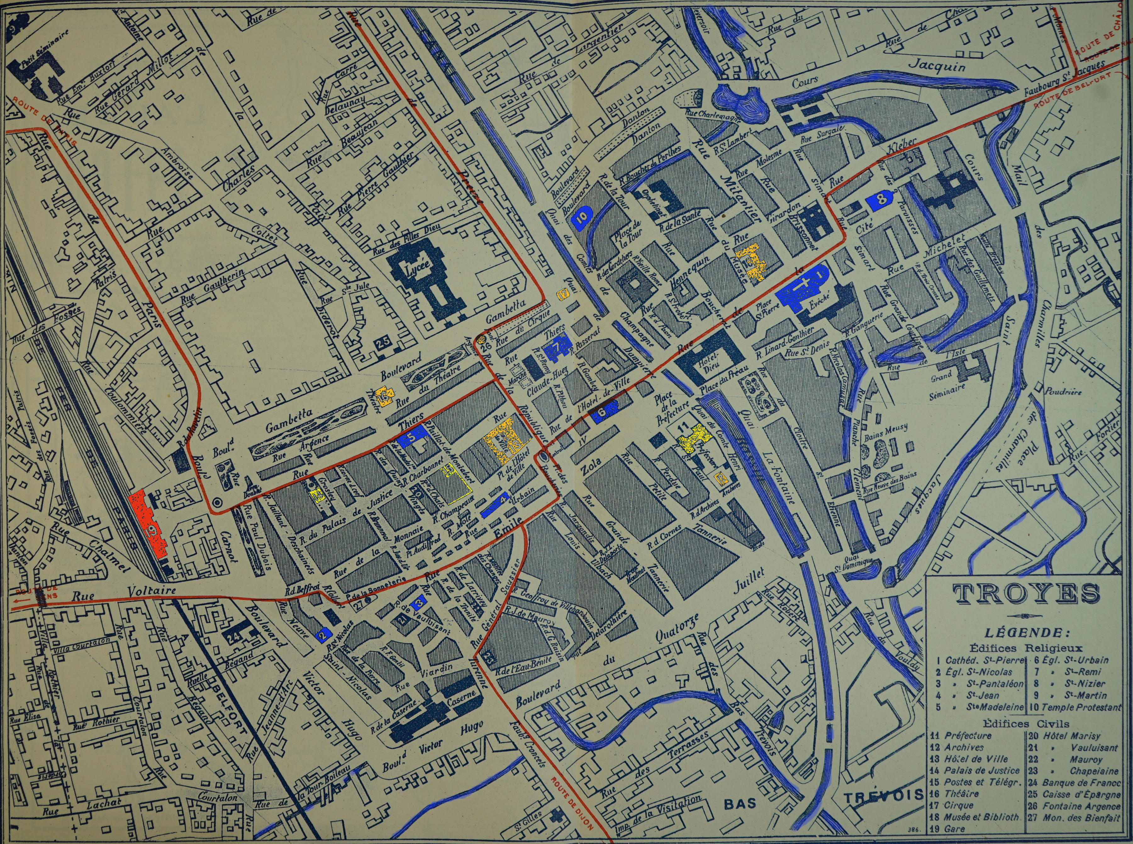
Troyes 1911 plan 06043.jpg - Garitan

EB1911 Tibet - southern Tibet.jpg - Library Guy
The Faroes.jpg - LlywelynII

Great Northern Expedition (Berindg-Chirikov 1741 route).png - Kaidor
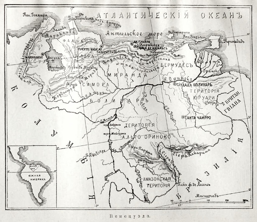
Карта к статье «Венецуэла». Военная энциклопедия Сытина (Санкт-Петербург, 1911-1915).jpg - Schekinov Alexey Victorovich
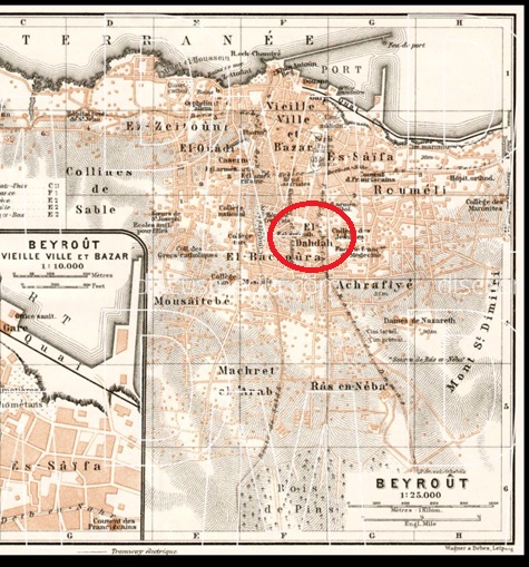
1911 Beirut map.jpg - Ealdahdah

Руска Рада. Ч. 4. Русини а Москалї. 1911. Руська земля в 1700 роцї.png - Artem.komisarenko

Atlas-Mass-Holyoke 1911 015.jpg - Simtropolitan

Atlas-Mass-Holyoke 1911 014.jpg - Simtropolitan

Atlas-Mass-Holyoke 1911 012.jpg - Simtropolitan

Atlas-Mass-Holyoke 1911 013.jpg - Simtropolitan

Atlas-Mass-Holyoke 1911 010.jpg - Simtropolitan

Atlas-Mass-Holyoke 1911 011.jpg - Simtropolitan

Atlas-Mass-Holyoke 1911 009.jpg - Simtropolitan
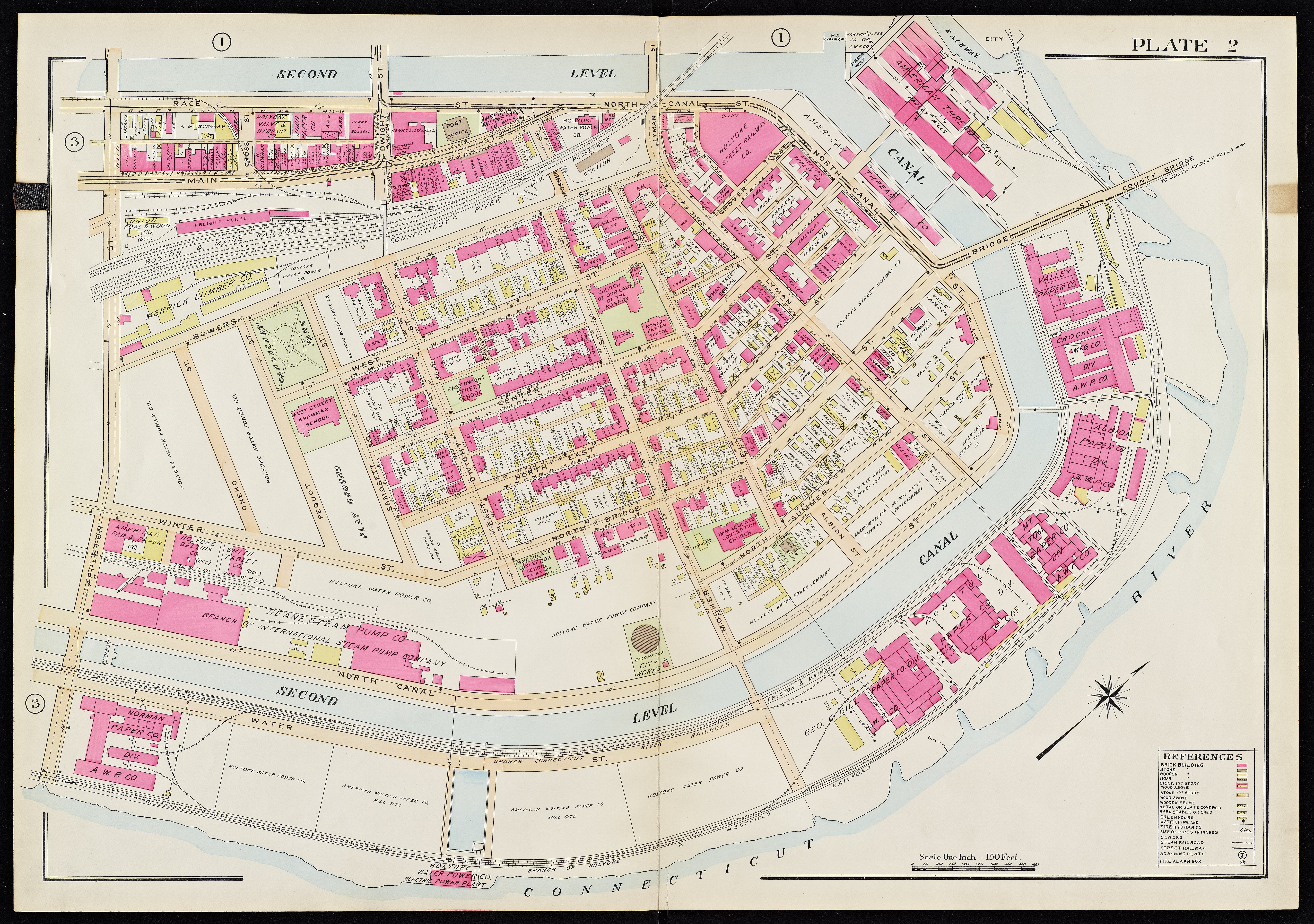
Atlas-Mass-Holyoke 1911 008.jpg - Simtropolitan

Atlas-Mass-Holyoke 1911 007.jpg - Simtropolitan

Atlas-Mass-Holyoke 1911 006.jpg - Simtropolitan

London Open Air Sanatorium Ordnance Survey map 1911.jpg - Philafrenzy

EB1911 Map Projection - Fig. 27.—Plane Table Graticule.jpg - DivermanAU

Карта мелитопольского уезда 1911 года.jpg - DENAMAX

Spratly Islands partial nautical charts of 1911.jpg - Pemu

North Danger Reef nautical chart of 1911 (cropped).jpg - Ratzer
Loaita Bank nautical chart of 1911 (cropped).jpg - Ratzer
Williams map of Long Island City section of Queens Borough, New York. LOC 2003630671.tif - Fæ
Thitu Reefs and Subi Reef nautical chart of 1911 (cropped).jpg - Ratzer

Tizard Bank nautical chart of 1911 (cropped).jpg - Ratzer

Derrotero útil y provechoso y en todo verdadero de Rios, caños, lagunas, montes, poblaciones, envarcaderos, baraderos,rancherías, el qual reza desde la ciudad de San Agustin hasta la varra de Aiz LOC 2009579241.jpg - Fæ

Map of the permanent system of highways, District of Columbia LOC 87691462.jpg - Fæ
North and South, map of main-traveled routes - showing principal roads in the Northern and Central Western States, and their connections with the main-traveled highways of the South - (Eastern U.S.) LOC 2011587112.tif - Fæ

North and South, map of main-traveled routes - showing principal roads in the Northern and Central Western States, and their connections with the main-traveled highways of the South - (Eastern U.S.) LOC 2011587112.jpg - Fæ
Massachusetts Avenue Heights, Washington, D.C. LOC 88690949.tif - Fæ

Massachusetts Avenue Heights, Washington, D.C. LOC 88690949.jpg - Fæ

Map of Carroll County, Md., showing rural delivery service LOC 2012585334.jpg - Fæ

Map of the permanent system of highways, District of Columbia LOC 80693405.jpg - Fæ
(Derrotero útil y provechoso y en todo verdadero de Rios, caños, lagunas, montes, poblaciones, envarcaderos, baraderos,rancherías, el qual reza desde la ciudad de San Agustin hasta la varra de Aiz LOC 2009579241.tif - Fæ
The National Geographic Magazine map of Mexico LOC 2010593157.tif - Fæ
The "Standard guide" ready reference map of Washington - to accompany the "Washington standard guide" LOC 80693175.tif - Fæ

The "Standard guide" ready reference map of Washington - to accompany the "Washington standard guide" LOC 80693175.jpg - Fæ

Planta de Terrenos na 5ª Parada - 1 (1), Acervo do Museu Paulista da USP.jpg - GiFontenelle

Planta de Terrenos na 5ª Parada - 1 (2), Acervo do Museu Paulista da USP.jpg - GiFontenelle

Planta de Terrenos na 5ª Parada - 1 (3), Acervo do Museu Paulista da USP.jpg - GiFontenelle

Planta de Terrenos na 5ª Parada - 3, Acervo do Museu Paulista da USP.jpg - GiFontenelle

Alexandria (1).jpg - Marcok
Map of Rock Creek Park - December 1911 - (Washington D.C.) LOC 88693048.tif - Fæ

Velike Pochaivske Lake, 1911.jpg - ZxcvU

EB1911 Manchuria.png - LlywelynII

EB1911 Glacial Period Map.jpg - Chuntuk
Il tricolore Italiano in Tripolitania e Cirenacia - diario illustrato della guerra Italo-Turca . LOC 2017589624.tif - Fæ

Il tricolore Italiano in Tripolitania e Cirenacia - diario illustrato della guerra Italo-Turca . LOC 2017589624.jpg - Fæ

Diadochi 301 Shepherd-es.svg - Rowanwindwhistler

Diádocos-200AC-es.svg - Rowanwindwhistler

Armenia map detail, from- Shepherd-c-020 (cropped).jpg - Tibet Nation

Katzenhagen 1911.Ausschnitt Meßtischblatt 2446.jpg - 16Exul82
Holyoke Street Railway old carbarn, from Richard's Atlas (1911).jpg - Simtropolitan

British Guiana 1911 map - Storm van's Gravesande; the rise of British Guiana (IA riseofbritishguiana01stor) (page 10 crop).jpg - Ooligan

Belgorod Map 1911.jpg - Лобачев Владимир

Kaart van Limburg voor 1794 (RAL K 061).jpg - Kleon3

Troyes 1911 plan 06043 (turenne).jpg - Gérald Garitan

Elmwood Park, Holyoke, Massachusetts (from Richards 1911).jpg - Simtropolitan
Ponce de Leon Park Atlanta 1911 Sanborn map.jpg - Baseball Bugs

Everglades 1911.jpg - ViewingHabit

Heinrich Kiepert, Palaestina (FL6882107 2367778).jpg - Geagea

אטלס תנך 15 (FL170208376 3565668).jpg - Geagea

אטלס תנך 16 (FL170208377 3565668).jpg - Geagea

Kaart van Limburg voor 1794 (RAL K 061) (crop Zuid-Limburg).jpg - Kleon3

Topographische Karte 1 25000 Blatt 181 (8324) Neukirch Achberg 1911.jpg - Ricardalovesmonuments