Wikimedi'Òc
Modes d'emploi

Cet album fait partie des albums
Cet album photos contient les sous-albums suivants :


Implantations Groupe Prévoir.jpg - DelphineP

Kremlin1910.jpg - Morpheios Melas
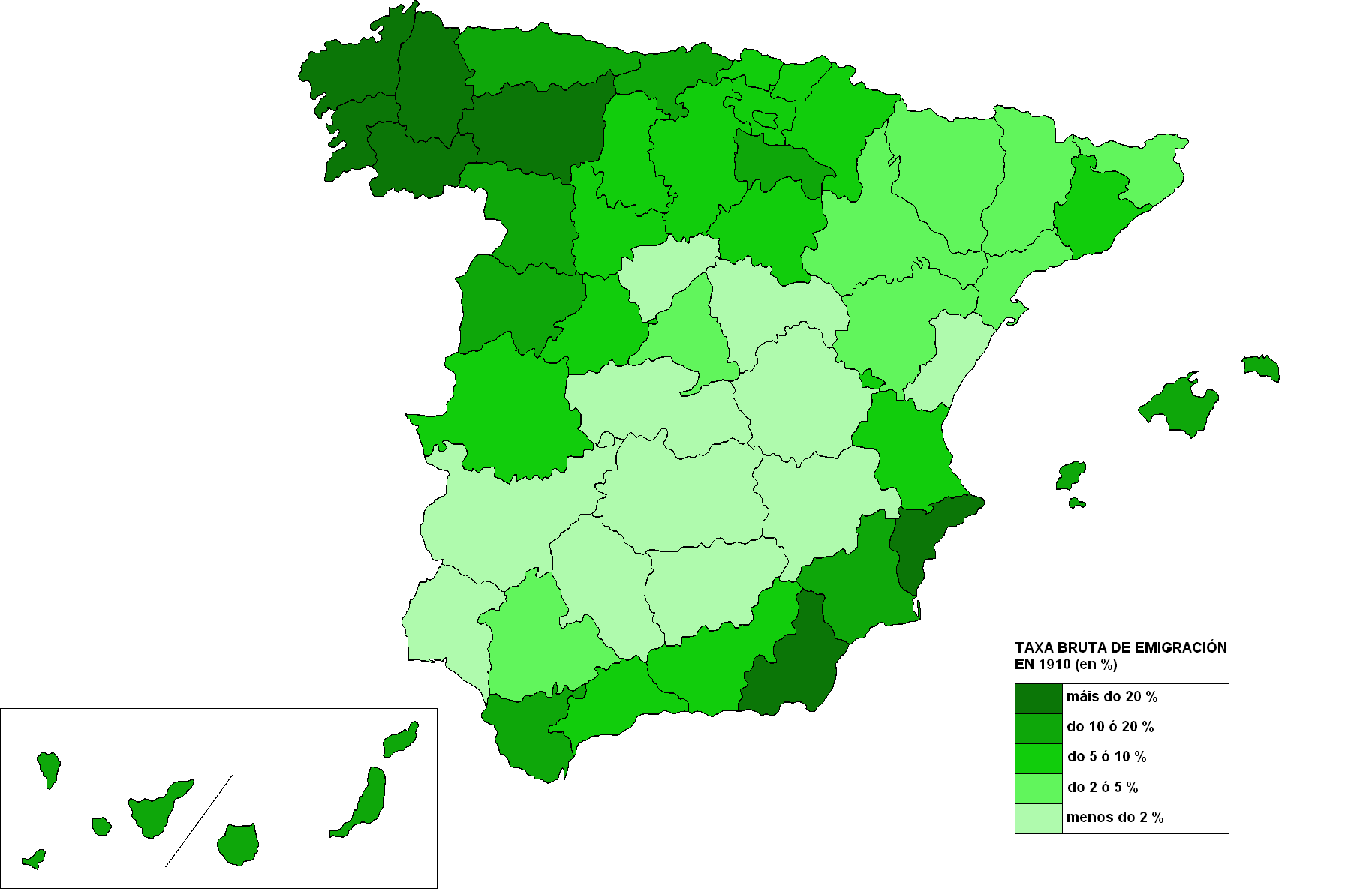
Emigracion espanha 1910.png - Norrin strange

Direccion.general.de.obras.publicas.Chile.jpg - Keysanger
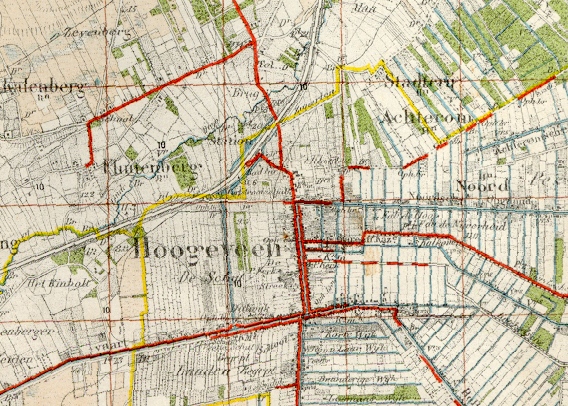
Topografische kaart Hoogeveen 1910.jpg - BotMultichill

Őrség, Vendvidék 1910.jpg - Doncsecz
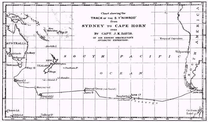
Nimrod.1909 voyage.jpg - Goustien
IllinoisTunnelMap1910.png - Douglas W. Jones

1910 Atlas of the Sino-Japanese War (25 rare folding maps) - Geographicus - SinoJapanese-japan-1910.jpg - BotMultichillT

1910 Leconte Monument Map of Paris, France - Geographicus - ParisMonumental-leconte-1910.jpg - BotMultichillT

1910 Smith's Tape Indicator Map of London ( Pocket Map ) - Geographicus - London-smith-1910.jpg - BotMultichillT
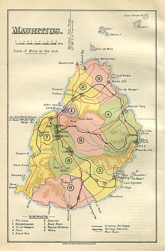
Mauritius Waterlow map 1910.jpg - Bahnfrend

Duklja map.jpg - File Upload Bot (Magnus Manske)
Turkey in Europe and the Balkans, 1910.jpg - Underlying lk
New Orleans Map the Creole Guide 1910.jpg - Infrogmation

План Николаева 1910.jpg - Aleksandrit

CARTE trajet avion.jpg - JPSIMONIN

Messtischblatt 2176 Lubichow part.jpg - ONAR

Messtischblatt Lubichow 1908 part Forst Wirthy.jpg - Lienhard Schulz

Tour de France 1910 map-fr.svg - BaldBoris

Map of the City of Somerville (9137935790).jpg - File Upload Bot (Magnus Manske)
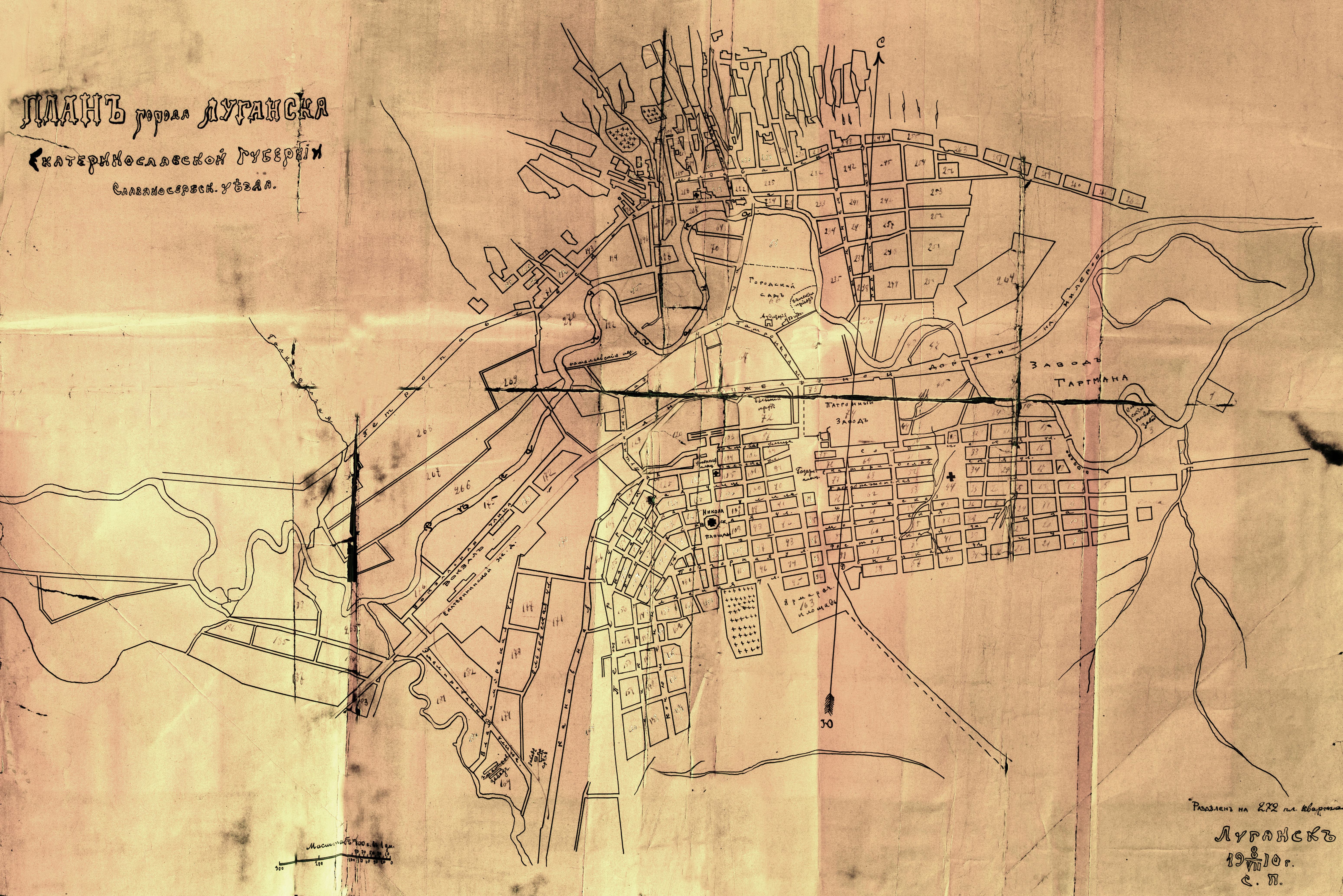
План Луганска 1910.jpg - Миша историк

Map of City Hall Park in New York City.jpeg - Vzeebjtf

Načrt mesta Ljubljana 1910.jpg - Sporti

Spezialkarte der Österreichisch-ungarischen Monarchie - Adelsberg 1910.jpg - Sporti

Spezialkarte der Österreichisch-ungarischen Monarchie - Bischoflack und Idria 1910.jpg - Sporti

Spezialkarte der Österreichisch-ungarischen Monarchie - Mozirje 1910.jpg - Sporti

Plan de la ville de Quimper (1910).jpg - Piero~commonswiki
Avio und Valdagno. NYPL1226841.tiff - Fæ
Balassa-Gyarmat und Ipoly-Sag. NYPL1226537.tiff - Fæ
Balatonfured und Varos-Hidveg. NYPL1226697.tiff - Fæ
Balazsfalva (Blasendorf). NYPL1226805.tiff - Fæ
Barot. NYPL1226808.tiff - Fæ
Belenyes und Sulest. NYPL1226740.tiff - Fæ
Belovar und Grdjevac Veliki. NYPL1226821.tiff - Fæ
Beresteczko und Szczurowice. NYPL1226306.tiff - Fæ
Berzaszka und O-Ogradina. NYPL1226949.tiff - Fæ
Berzence und St. Georgen. NYPL1226791.tiff - Fæ
Bicske und Martonvasar. NYPL1226632.tiff - Fæ
Bludenz und Vaduz. NYPL1226648.tiff - Fæ
Bresztovacz. NYPL1226946.tiff - Fæ
Brod. NYPL1226904.tiff - Fæ
Czegled. NYPL1226668.tiff - Fæ
Debreczen. NYPL1226603.tiff - Fæ
Deva und Szaszvaros. NYPL1226833.tiff - Fæ
Dubrava und Gradec. NYPL1226820.tiff - Fæ
Dukla-Pasz (Galizien). NYPL1226404.tiff - Fæ
Durnkrut und Bosing. NYPL1226505.tiff - Fæ
Enns und Steyr. NYPL1226528.tiff - Lewenstein
Esseg, Darda und Valpovo. NYPL1226853.tiff - Fæ
Facset. NYPL1226831.tiff - Fæ
Gattaja und Dognacska. NYPL1226886.tiff - Fæ
Giralt. NYPL1226431.tiff - Fæ
G. Meseritsch. NYPL1226393.tiff - Fæ
Gmund und Spittal. NYPL1226688.tiff - Fæ
Goding und Lundenburg. NYPL1226448.tiff - Fæ
Goncz und Csobad (Ungarn). NYPL1226513.tiff - Fæ
Gorgenyszentimre. NYPL1226711.tiff - Fæ
Gradiste und Bos. Samac. NYPL1226905.tiff - Fæ
Grosz-Glockner. NYPL1226654.tiff - Sebastian Wallroth
Gyongyos und Bakta (Ungarn). NYPL1226566.tiff - Fæ
Handlova und Oszlany (Ungarn). NYPL1226478.tiff - Fæ
Hartberg und Pinkafeld (Ankafo). NYPL1226627.tiff - Fæ
Harrachsdorf. NYPL1226272.tiff - Fæ
Hegyes-Kis-Somlyo. NYPL1226663.tiff - Fæ
Hohenelbe. NYPL1226279.tiff - Fæ
Hohenems. NYPL1226614.tiff - Fæ
Hohenmauth und Leitomischl. NYPL1226339.tiff - Fæ
Jagielnica und Czernelica. NYPL1226466.tiff - Sebastian Wallroth
Jaslo und Dukla. NYPL1226376.tiff - Fæ
Jaska. NYPL1226847.tiff - Fæ
Kaal und Jasz-Bereny. NYPL1226600.tiff - Fæ
Karlowitz und Titel. NYPL1226908.tiff - Fæ
Kassa (Kaschau) (Ungarn). -9916 NYPL1226484.tiff - Fæ
Kirchdorf. NYPL1226554.tiff - Finavon
Kisszeben. NYPL1226430.tiff - Fæ
Kostajnica und Novi. NYPL1226901.tiff - Fæ
Kuty (Galizien). NYPL1226521.tiff - Fæ
Nyaradto und Nagy-Kend. NYPL1226776.tiff - Fæ
Nyiregyhaza und Hajdu-Nans. NYPL1226569.tiff - Fæ
Ober Wikow. NYPL1226577.tiff - Fæ
Ober Hallabrunn. NYPL1226473.tiff - Fæ
Obuda, (Budapest). NYPL1226598.tiff - Fæ
Oradna und Naszod. NYPL1226644.tiff - Fæ
Sellye und Nagy-Surany. NYPL1226535.tiff - Fæ
Skender-Vakuf und Paklarevo. NYPL1226957.tiff - Fæ
Slatina und Vocin. NYPL1226851.tiff - Fæ
St. Michael. NYPL1226656.tiff - Fæ
Brzezany (Galizien). NYPL1226411.tiff - Sebastian Wallroth
Budapest und Teteny. NYPL1226633.tiff - Fæ
Szekesfehervar und Seregelyes. NYPL1226666.tiff - Fæ
Szerednye. NYPL1226488.tiff - Fæ
Zvornik. NYPL1226960.tiff - Fæ
Wola Michowa u. Izbugyarhdvany. NYPL1226432.tiff - Fæ
Warasdin und Kotor. NYPL1226760.tiff - Fæ
Visoko. NYPL1226987.tiff - Fæ
Veszprem und Varpalota (Ungarn). NYPL1226665.tiff - Finavon
Velika Corica und Lekenik. NYPL1226848.tiff - Fæ
Unt. Drauburg. NYPL1226725.tiff - Fæ
Unie und Sansego. NYPL1226933.tiff - Fæ
Ujscie Solne. NYPL1226322.tiff - Fæ
Tyrnau. NYPL1226506.tiff - Fæ
Travnik und Bugojno. NYPL1226972.tiff - Fæ
Tot-Prona und Privigye. NYPL1226451.tiff - Fæ
Toketerebes und Nagyszalancz. NYPL1226486.tiff - Fæ
Tepl und Tuschkau. NYPL1226333.tiff - Fæ
Saros-Nagypatak und Satoralja-Ujhely. NYPL1226514.tiff - Fæ
Sarengrad und Batrovci. NYPL1226906.tiff - Fæ
Salgo-Tarjan und Nagyszecseny. NYPL1226538.tiff - Fæ
Rosenau und Szilas. NYPL1226482.tiff - Fæ
Rohitsch und Drachenburg. NYPL1226788.tiff - Fæ
Ragusa. NYPL1227033.tiff - Fæ
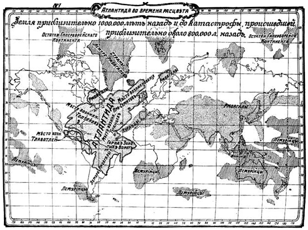
Map of Atlantis.jpg - SERGEJ2011

BosanskiSrbi1910.png - GifTagger

Bars county administrative map.jpg - Szilas
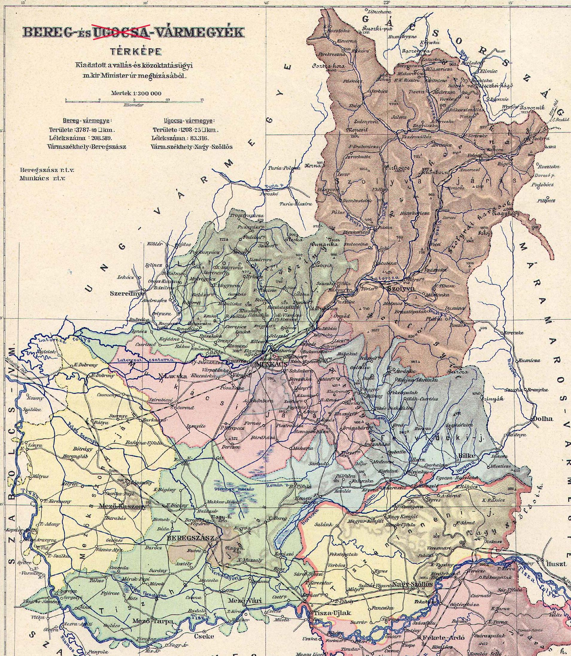
Bereg county administrative map.JPG - Szilas
Nauru map 1914 15000.tiff - Ratzer

Nauru map 1914 15000.png - BlueBreezeWiki

Nauru map 1914 15000.jpg - MagentaGreen

1910 moscow-tramway.jpg - Well-Informed Optimist

1910 Novgorod.jpg - Well-Informed Optimist

BAEDEKER(1910) p279 Eisenach.jpg - Metilsteiner

BAEDEKER(1910) p280 Wartburg.jpg - Metilsteiner

Senate Atlas, 1870–1907. Sheet XXIII-XXIV 12-13 Merikarvia.jpg - Susannaanas

Senate Atlas, 1870–1907. Sheet XXIII-XXIV 14-15 Siikainen.jpg - Susannaanas
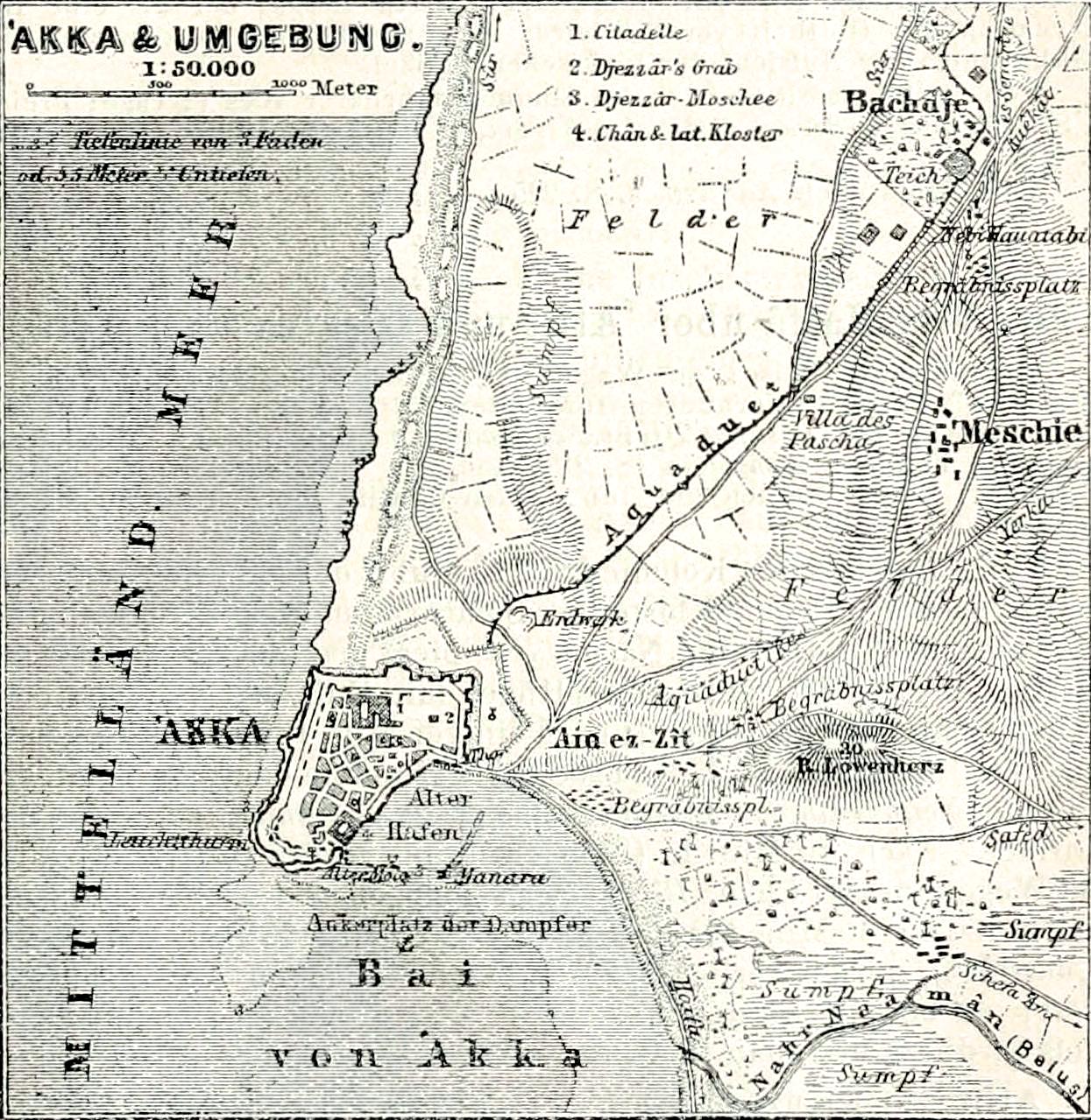
Karl Baedeker. Akka & Umgebung (1910) (14766736185).jpg - Geagea

Annual report of the Secretary of the Board of Agriculture" (1854-1915) (18744761064).jpg - Fæ

The American journal of science (1910) (18152825815).jpg - Fæ

The American journal of science (1910) (17964834770).jpg - SteinsplitterBot

The American journal of science (1910) (18152535135).jpg - SteinsplitterBot

Abhandlungen der Senckenbergischen Naturforschenden Gesellschaft (1910) (16580523470).jpg - SteinsplitterBot

Abhandlungen der Senckenbergischen Naturforschenden Gesellschaft (1910) (16560645167).jpg - SteinsplitterBot

Abhandlungen der Senckenbergischen Naturforschenden Gesellschaft (1910) (16766824122).jpg - Fæ

FMIB 34692 Map of Glacier Bay.jpeg - BMacZeroBot

FMIB 34713 Map of Yakutat Bay, Showing Configuration of Bottom.jpeg - BMacZeroBot

FMIB 50526 General plan of ground floor of station buildings at Roscoff.jpeg - BMacZeroBot

FMIB 50529 Fittings of Investigators' room, Roscoff station.jpeg - BMacZeroBot

Cyclopedia of American government (1914) (14589358490).jpg - SteinsplitterBot

The encyclopdia britannica; a dictionary of arts, sciences, literature and general information (1910) (14777822684).jpg - Fæ

The Commercial and financial chronicle (1910) (14577828339).jpg - Fæ

New geographies (1910) (14783796465).jpg - Fæ

Berlin Innere Stadt Meyers Konversationslexikon ca1910.jpg - Alexrk2

Das Kürschner-Handwerk, 3. Teil, S. 27, Weltkarte Verbreitung des Edel- oder Baummarders.jpg - Kürschner

Das Kürschner-Handwerk, 3. Teil, S. 27, Weltkarte Verbreitung des Steinmarders.jpg - Kürschner

Das Kürschner-Handwerk, 3. Teil, S. 27, Weltkarte Verbreitung des Kolinskys.jpg - Kürschner

Das Kürschner-Handwerk, 3. Teil, S. 28, Weltkarte Verbreitung des Pecans oder Virginischen Iltis.jpg - Kürschner

Das Kürschner-Handwerk, 3. Teil, S. 30, Weltkarte Verbreitung des Nerzes.jpg - Kürschner

Das Kürschner-Handwerk, II. Auflage 3. Teil, S. 29, Weltkarte Verbreitung des Iltisses.jpg - Kürschner

Das Kürschner-Handwerk, II. Auflage 3. Teil, S. 33, Weltkarte Verbreitung des Hermelins (1910).jpg - Kürschner

Das Kürschner-Handwerk, II. Auflage 3. Teil, S. 34, Weltkarte Verbreitung des Vielfraßes (1910).jpg - Kürschner

Das Kürschner-Handwerk, II. Auflage 3. Teil, S. 40, Weltkarte Verbreitung des Maulwurfs (1910).jpg - Kürschner

Das Kürschner-Handwerk, II. Auflage 3. Teil, S. 41, Weltkarte Verbreitung des Silberbisams (1910).jpg - Kürschner

Das Kürschner-Handwerk, II. Auflage 3. Teil, S. 44, Weltkarte Verbreitung der Silberfüchse und der Kreuzfüchse (1910).jpg - Kürschner

Das Kürschner-Handwerk, II. Auflage 3. Teil, S. 44, Weltkarte Verbreitung der Rotfüchse (1910).jpg - Kürschner

Das Kürschner-Handwerk, II. Auflage 3. Teil, S. 45, Weltkarte Verbreitung der Grisfüchse, Kittfüchse und Wüstenfüchse (1910).jpg - Kürschner

Das Kürschner-Handwerk, II. Auflage 3. Teil, S. 46, Weltkarte Verbreitung der Polarfüchse (1910).jpg - Kürschner

Das Kürschner-Handwerk, II. Auflage 3. Teil, S. 46, Verbreitung der Südamerikanischen Füchse (1910).jpg - Kürschner

Das Kürschner-Handwerk, II. Auflage 3. Teil, S. 51, Weltkarte Verbreitung der Hyänen (1910).jpg - Kürschner

Das Kürschner-Handwerk, II. Auflage 3. Teil, S. 51, Weltkarte Verbreitung der Schakale (1910).jpg - Kürschner

Das Kürschner-Handwerk, II. Auflage 3. Teil, S. 52, Weltkarte Verbreitung der Dachse (1910).jpg - JMK

Das Kürschner-Handwerk, II. Auflage 3. Teil, S. 54, Weltkarte Verbreitung der Viverrenhunde (1910).jpg - Kürschner

Das Kürschner-Handwerk, II. Auflage 3. Teil, S. 57, Weltkarte Verbreitung der Biber, Bisam und Nutria (1910).jpg - Kürschner

Das Kürschner-Handwerk, II. Auflage 3. Teil, S. 60, Weltkarte Verbreitung der Viscacha, Chinchilla, Hamster und Bilch (1910).jpg - Kürschner

Das Kürschner-Handwerk, II. Auflage 3. Teil, S. 65, Weltkarte Verbreitung Krimmer, Astrachan, Persianer und Breitschwanz, Tibetschafe (1910).jpg - Kürschner

Das Kürschner-Handwerk, II. Auflage 3. Teil, S. 71, Weltkarte Verbreitung Seebären (1910).jpg - Kürschner

Das Kürschner-Handwerk, II. Auflage 3. Teil, S. 76, Weltkarte Verbreitung der Fischottern, kanadischer Ottern und Seeottern (1910).jpg - Kürschner

Das Kürschner-Handwerk, II. Auflage 3. Teil, S. 81, Weltkarte Verbreitung der Kloakentiere und der Beuteltiere (1910).jpg - Kürschner

Lechner's General-Karte von Krain 1910.jpg - Sporti

Map of Slovenia cca 1910.jpg - Sporti

276 of 'The Earth and its Inhabitants. The European section of the Universal Geography by E. Reclus. Edited by E. G. Ravenstein. Illustrated by ... engravings and maps' (11122150154).jpg - Artix Kreiger 2

Hawaii Hammond 1910 map.jpg - Ratzer

Pennsylvania Railroad Station, New York city - Seventh Avenue and Thirty-Second Street, looking towards Long Island LOC 2011593041.jpg - Fæ
Yellowstone National Park. LOC 97683558.tif - Fæ

Yellowstone National Park. LOC 97683558.jpg - Fæ
Cadastral map of Massachusetts Avenue N.W. and adjacent parts of American University Park and Spring Valley, Washington D.C. LOC 88690947.tif - Fæ

Cadastral map of Massachusetts Avenue N.W. and adjacent parts of American University Park and Spring Valley, Washington D.C. LOC 88690947.jpg - Fæ
Subject nationalities of the German alliance - from the Allies' peace terms as stated in their reply to President Wilson's note of 19th Dec. 1916 - (Eurasia). LOC 2004628224.tif - Fæ

Subject nationalities of the German alliance - from the Allies' peace terms as stated in their reply to President Wilson's note of 19th Dec. 1916 - (Eurasia). LOC 2004628224.jpg - Fæ
City of Washington and suburbs. LOC 89694323.tif - Fæ

City of Washington and suburbs. LOC 89694323.jpg - Fæ
Central America. LOC 2003627061.tif - Fæ

Central America. LOC 2003627061.jpg - Fæ
(Mormon Temple Salt Lake City). LOC 99446203.tif - Fæ

(Mormon Temple Salt Lake City). LOC 99446203.jpg - Fæ
City of Washington and suburbs. LOC 87691459.tif - Fæ

City of Washington and suburbs. LOC 87691459.jpg - Fæ
Map of the Spokane Indian Reservation, Stevens County, Washington. LOC 98687156.tif - Fæ

Map of the Spokane Indian Reservation, Stevens County, Washington. LOC 98687156.jpg - Fæ
Map of the city of Newport News, Virginia - G.W. Fitchett, city engineer ; G. Doyle, delineator. LOC 95682668.tif - Fæ

Map of the city of Newport News, Virginia - G.W. Fitchett, city engineer ; G. Doyle, delineator. LOC 95682668.jpg - Fæ

Map of Washington, D.C. LOC 87691461.jpg - Fæ
Map showing property of Beaver Creek Consolidated Coal Co. in Floyd, Knott and Magoffin counties, Kentucky LOC 2012586605.tif - Fæ

Map showing property of Beaver Creek Consolidated Coal Co. in Floyd, Knott and Magoffin counties, Kentucky LOC 2012586605.jpg - Fæ
Map of the Confederate States of America. (1861-65) LOC 99447182.tif - Fæ

Map of the Confederate States of America. (1861-65) LOC 99447182.jpg - Fæ
Map of Brookdale, Santa Cruz Co., Cal. being part of Section 32, T.9S. R. 2 W., M.D.M. LOC gm69001757.tif - Fæ

Map of Brookdale, Santa Cruz Co., Cal. being part of Section 32, T.9S. R. 2 W., M.D.M. LOC gm69001757.jpg - Fæ
Map of Gettysburg battlefield LOC 99448797.tif - Fæ

Map of Gettysburg battlefield LOC 99448797.jpg - Fæ

Nôvo Mapa dos Caminhos de Ferro do Estado de S. Paulo e dos Estados Limitrophes - 5, Acervo do Museu Paulista da USP.jpg - GiFontenelle

Nôvo Mapa dos Caminhos de Ferro do Estado de S. Paulo e dos Estados Limitrophes - 6, Acervo do Museu Paulista da USP.jpg - GiFontenelle
Map of the Russian Campaign 1812 LOC 2012593516.tif - Fæ

Map of the Russian Campaign 1812 LOC 2012593516.jpg - Fæ

Planta do Rio Turvo, Acervo do Museu Paulista da USP.jpg - GiFontenelle
Plano catastral de la provincia de Mendoza LOC 2009579452.tif - Fæ

Plano catastral de la provincia de Mendoza LOC 2009579452.jpg - Fæ
Hammond's new guide map of Manhattan and the Bronx. LOC 79695063.tif - Fæ
Yellowstone National Park. LOC 97683515.tif - Fæ

Yellowstone National Park. LOC 97683515.jpg - Fæ
Map of the Confederate States of America. LOC lva0000071.tif - Fæ

Map of the Confederate States of America. LOC lva0000071.jpg - Fæ

Birdseye view of Rochester and Despatch LOC 2009584359.jpg - Fæ

Ostrivs'ke Lake, 1910.jpg - WithUinH
Ostrovats'ke Lake, 1910.jpg - WithUinH

Topografische kaart Rhoon 1910.png - Hanhil
Lake Omyt in Zarichne Raion, 1910.jpg - ZxcvU

Lake Velyke in Zarichne Raion, 1910.jpg - ZxcvU

Lake Zadovzhe in Zarichne Raion, 1910.jpg - ZxcvU

Universidad de Sevilla en mapa de 1910.png - Hispalois
Part of the United States in 1777. LOC 2018590034.tif - Fæ

Part of the United States in 1777. LOC 2018590034.jpg - Fæ

An old map of Harar featuring the Somali Gadabuursi Dir clan.jpg - MustafaO

Awamoko Survey District.jpg - F.newnham

Map of the Confederate States of America, LOC lva0000071.jpg - Taterian

"LOANED BY THE AMERICAN GEOGRAPHICAL SOCIETY BROADWAY AT 156th ST., NEW YORK TO THE PEACE CONFERENCE AT VERSAILLES 1918- 1919" detail from 1914 Survey of India map of Tibet and Adjacent Countries (cropped) (cropped).jpg - Tibet Nation

Congo wall map - Physical - AfricaMuseum.jpg - Hispalois

Congo wall map - Exploration itineraries - AfricaMuseum.jpg - Hispalois

Japan British Exhibition Map 1910.png - Asteuartw

Plan of South Boston Flats Showing Present Condition and Sketch of Proposed Docks and Streets to Accompany Annual Report of Harbor and Land Commissioners.jpg - Daderot

Map of the island of Malta (1910).jpg - Austiger

Carte geologique de la Nouvelle-Caledonie et de ses dependances.jpg - Austiger

Map of the tourist districts of the Blue Mountains, the Illawarra and the Southern Highlands of New South Wales.jpg - Austiger
Kaiser Wilhelms Land Nord-Ost-Küste.jpg - Austiger

Keifu Testudō senro ryakuzu; Fu Tōyō Tetsudō senro ryakuzu.jpg - Austiger

Bacon's map of north Wales.jpg - Austiger

Rainfall map of Australia, 1897-1906.jpg - Austiger

Victoria - showing irrigation & water supply districts & works.jpg - Austiger

Tarn Wadling map.jpg - SchroCat

John George Bartholomew, Palestine (FL35090238 3892016).jpg - Geagea

Jerusalem die Heilige Stadt und Umgebung (FL25570504 2729445).jpg - Geagea

Modern Palestine, the Suez canal & Sinai Peninsula (FL35090373 3891967).jpg - Geagea

Palestine ancient (FL35090312 3892031).jpg - Geagea

The division of Solomon's kingdom about 953 B.C (FL27965327 2654875).jpg - Geagea