Wikimedi'Òc
Modes d'emploi

Cet album fait partie des albums
Cet album photos contient les sous-albums suivants :


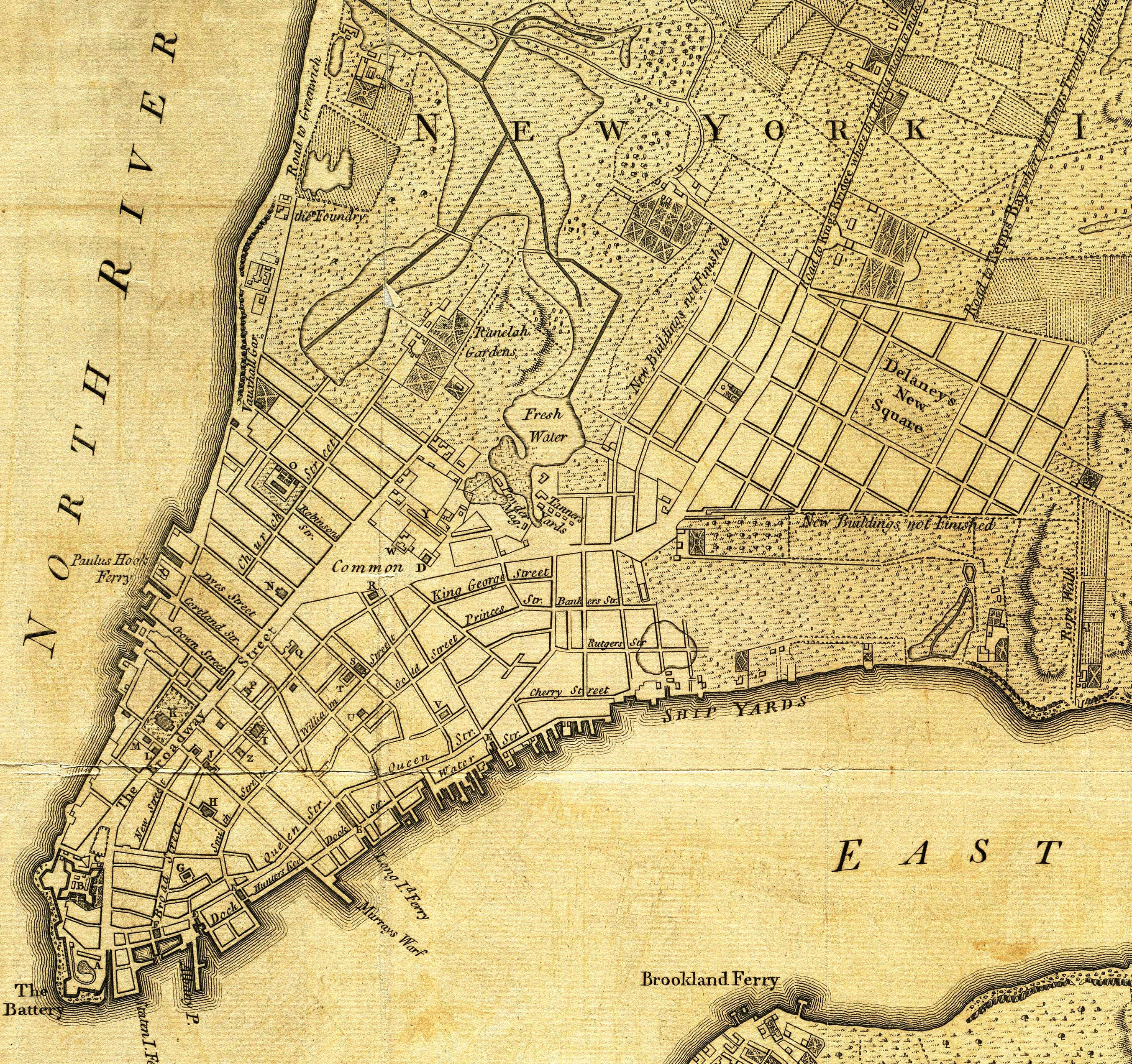
Manhattan1781.jpg - Beyond My Ken

Kartenblatt Florida Mexiko 9116.jpg - Joergens.mi
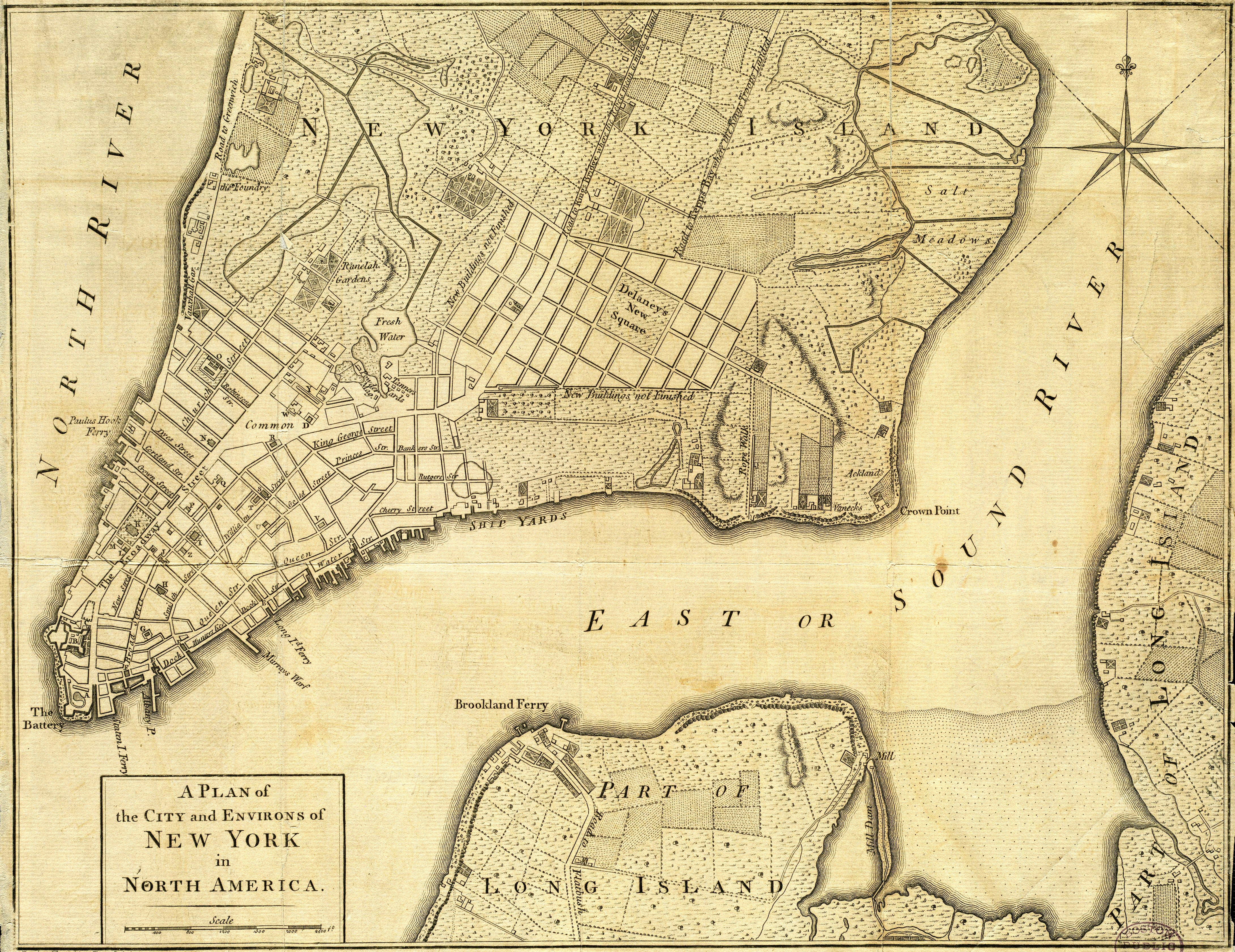
NYC1776.jpg - Magicpiano

1869 Kitchen - Shannon Map of New York City - Geographicus - NewYorkKitchin-mcny-1869.jpg - BotMultichill
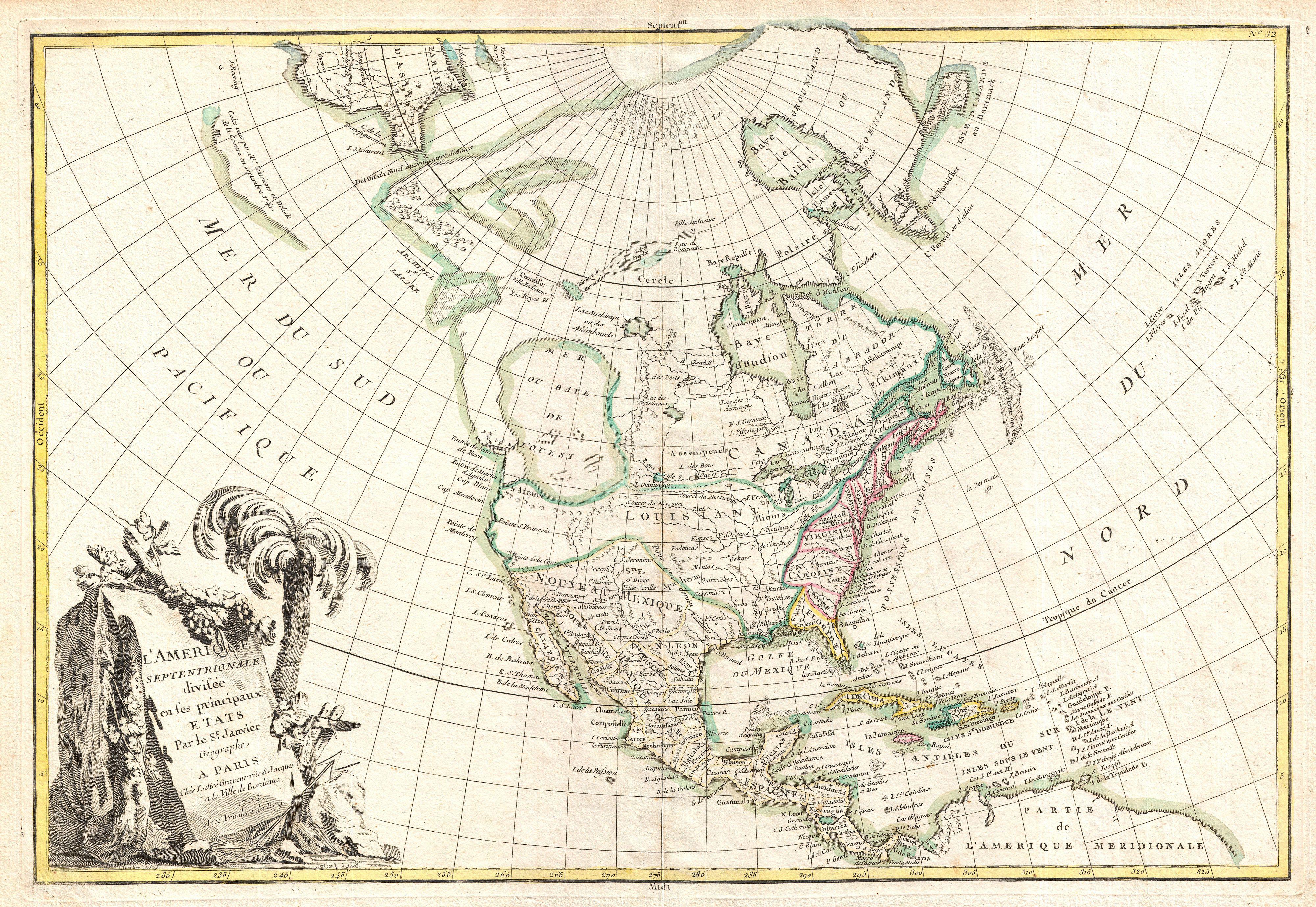
1762 Janvier Map of North America (Sea of the West) - Geographicus - NorthAmerica-janvier-1762.jpg - BotMultichillT

1796 Benjamin Taylor Manuscript Survey Map of Tribeca, New York and Indenture - Geographicus - Tribeca-taylor-1796.jpg - BotMultichillT

1780 Raynal and Bonne Map of North America - Geographicus - Amerique-bonne-1780.jpg - BotMultichillT
1720 Chatelain Map of North America - Geographicus - Amerique-chatelain-1720.jpg - BotMultichillT

1708 De L'Isle Map of North America (Covens and Mortier ed.) - Geographicus - AmeriqueSeptentrionale-covensmortier-1708.jpg - BotMultichillT
11496488@N07 2180396721.jpg - File Upload Bot (Magnus Manske)

Collect pond-negros burial ground-map.jpg - 7mike5000

Maerschalk-Map-Collect Pond Negros Burial Ground-1754.jpg - 7mike5000

Maerschalk-Map-Collect Pond Negros Burial Ground 2-1754.jpg - 7mike5000
1733 A Map Popple.jpg - Joop Rotte

Montgomerie's Ward, New York City.png - Hamblin

Maerschalck map of New York City.jpg - Hamblin

Montgomerie's Ward, New York City - jpg version.jpg - Hamblin

Théatre de la guerre en Amerique, avec les Isles Antilles (9471677029).jpg - File Upload Bot (Magnus Manske)

North America (9471676269).jpg - File Upload Bot (Magnus Manske)

A map of the British Empire in America with the French and Spanish settlements adjacent throughout (8347647660).jpg - File Upload Bot (Magnus Manske)

Amerique septentrionale avec les routes, distances en miles, villages, et etablissements François et Anglois (7537874226).jpg - File Upload Bot (Magnus Manske)

A New map of North America with the West India Islands, divided according to the preliminary articles of peace, signed at Versailles, 20. Jan. 1783 ... (6093656131).jpg - File Upload Bot (Magnus Manske)

Amérique septentrionale (4587171998).jpg - File Upload Bot (Magnus Manske)

A map of the northern and middle states, comprehending the western territory & the British dominions in North America from the best authorities (4231161815).jpg - File Upload Bot (Magnus Manske)

A map of the British Empire in America with the French and Spanish settlements adjacent thereto (4231929634).jpg - File Upload Bot (Magnus Manske)

A new map of the United States of North America with the British dominions on that continent &c. (4231156199).jpg - File Upload Bot (Magnus Manske)

This map of North America, according to ye newest and most exact observations is most humbly dedicated by your Lordships most humble servant Herman Moll, geographer (4071874777).jpg - File Upload Bot (Magnus Manske)

Nova tabula geographica complectens borealiorem Americae partem... (2674865685).jpg - File Upload Bot (Magnus Manske)

Nieuwe kaart van de Grootbrittannische volkplantingen in Noord America (2674732079).jpg - File Upload Bot (Magnus Manske)

A general map of the northern British Colonies in America (2675145130).jpg - File Upload Bot (Magnus Manske)

Amplissimae regionis Mississipi seu Provinciae Ludovicianae â R.P. (2674729570).jpg - File Upload Bot (Magnus Manske)

Recens edita totius Novi Belgii, in America Septentrionali siti (2673905113).jpg - File Upload Bot (Magnus Manske)

Nov(us) orbis sive America septentrionalis, divisa per sua regna provinc. et insul (2674718484).jpg - File Upload Bot (Magnus Manske)
Amerique septentrionale. NYPL434523.tiff - SteinsplitterBot
Amérique septentrionale - dressée sur les relations les plus modernes des voyageurs et navigateurs, et divisée suivant les differentes possessions des européens - par le Sr. Robert de Vaugondy, fils NYPL434038.tiff - Finavon
An accurate map of North America - drawn from the best modern maps and charts, and regulated by astron'l. observatns. - by Eman. Bowen, geog'r. to His Majesty, 1747. NYPL1258748.tiff - Fæ
A new and accurate map of North America - laid down according to the latest, and most approved observations and discoveries - R. W. Seale, sculpt. NYPL434068.tiff - Fæ
A New map of North America with the West India Islands - divided according to the preliminary articles of peace, signed at Versailles, 20, Jan. 1783, wherein are particularly distinguished the United NYPL434904.tiff - Fæ
An exact map of North America - from the best authorities - J. Lodge sculp. NYPL434857.tiff - Shattered Gnome
A general map of North America - in which is express'd the several new roads, forts, engagements, and taken from actual surveys and observations made in the army employ'd there, from the year 1754, to NYPL434911.tiff - Fæ
A general map of the northern British colonies in America - which comprehends the province of Quebec, the government of Newfoundland, Nova-Scotia, New-England and New-York - from the maps published by NYPL434913.tiff - SteinsplitterBot
A general map of North America - drawn from the best surveys - by J. Russell; J. Russell, sculpt, Constitution Row, Grey's Inn Lane. NYPL434510.tiff - SteinsplitterBot
A large draft of SOUTH CAROLINA from cape Roman to Port Royall NYPL1640623.tiff - Fæ
A new map of North America with the West India Islands - divided according to the preliminary articles of peace, signed at Versailles, 20, Jan. 1783; wherein are particularly distinguished the United NYPL464852.tiff - Fæ
Nova tabula geographica complectens borealiorem Americae partem - in qua exacte delineatae sunt Canada sive Nova Francia, Nova Scotia, Nova Anglia, Novum Belgium, Pensylvania, Virginia, NYPL465236.tiff - Fæ
Virginia, Marylandia et Carolina in America septentrionali Brittannorum industria excultae - repraesentatae à Ioh. Bapt. Homann, S.C.M. Geog. NYPL434005.tiff - Fæ
Virginia, Marylandia et Carolina in America septentrionali Britannorum industria excultae - repraesentatae à Ioh. Bapt. Homann, S.C.M. Geog. NYPL434111.tiff - Fæ
Regni Mexicani seu Novae Hispaniae, Ludovicianae, N. Angliae, Carolinae, Virginiae, Pensylvaniae, necnon insularum archipelagi Mexicani in America Septentrionali. NYPL484216.tiff - SteinsplitterBot
Regni Mexicani seu Novae Hispaniae, Ludovicianae, N. Angliae, Carolinae, Virginiae, Pensylvaniae, necnon insularum archipelagi Mexicani in America Septentrionali - accurata tabula exhibita à NYPL434125.tiff - Fæ
Regni Mexicani seu Novae Hispaniae, Ludovicianae, N. Angliae, Carolinae, Virginiae, Pensylvaniae, necnon insvlarvm archipelagi Mexicani in America Septentrionali - accurata tabula exhibita a NYPL434040.tiff - Finavon
Regni Mexicani seu Novae Hispaniae, Ludovicianae, N. Angliae, Carolinae, Virginiae, Pensylvaniae, necnon insularum archipelagi Mexicani in America Septentrionali. NYPL484214.tiff - Fæ
Regni Mexicani seu Novae Hispaniae, Floridae, Novae Angliae, Carolinae, Virginiae et Pensylvaniae necnon insularum archipelagi Mexicani in America Septentrionali NYPL484217.tiff - Fæ
Regni Mexicani seu Novae Hispaniae, Ludovicianae, N. Angliae, Carolinae, Virginiae, Pensylvaniae, ... in America Septentrionali NYPL483701.tiff - Shattered Gnome
Map of Hudson's River, with the adjacent country. NYPL435012.tiff - François de Dijon
Amerique Septentrionale (12797057304).jpg - Fæ

Miscellanies (1781) (14595131949).jpg - Fæ
The English pilot. (cartographic material) - The fourth book. Describing The West-India navigation, from Hudson's Bay to the River Amazones. Particularly delineating The Sea Coasts, Capes, Headlands, (14780240045).jpg - Fæ

Centennial history and handbook of Indiana; the story of the state from its beginning to the close of the civil war, and a general survey of progress to the present time (1915) (14576023458).jpg - SteinsplitterBot

Centennial history and handbook of Indiana - the story of the state from its beginning to the close of the civil war, and a general survey of progress to the present time (1915) (14760365214).jpg - SteinsplitterBot
NYC1776 crop.jpg - Beyond My Ken

A general map of North America - from the latest observations (NYPL b15346344-433898).jpg - Fæ

Nova tabula geographica complectens borealiorem Americae partem - in qua exacte delineatae sunt Canada sive Nova Francia, Nova Scotia, Nova Anglia, Novum Belgium, Pensylvania, Virginia, (NYPL b15201228-434920).jpg - SteinsplitterBot

(A chart of New York Island & North River, East River, passage through Hell Gate, Flushing Bay, Hampstead Bay, Oyster Bay, Huntington Bay, Cow Harbour, East Chester Inlet, Rochelle, Rye, (NYPL b14912001-434406).jpg - SteinsplitterBot

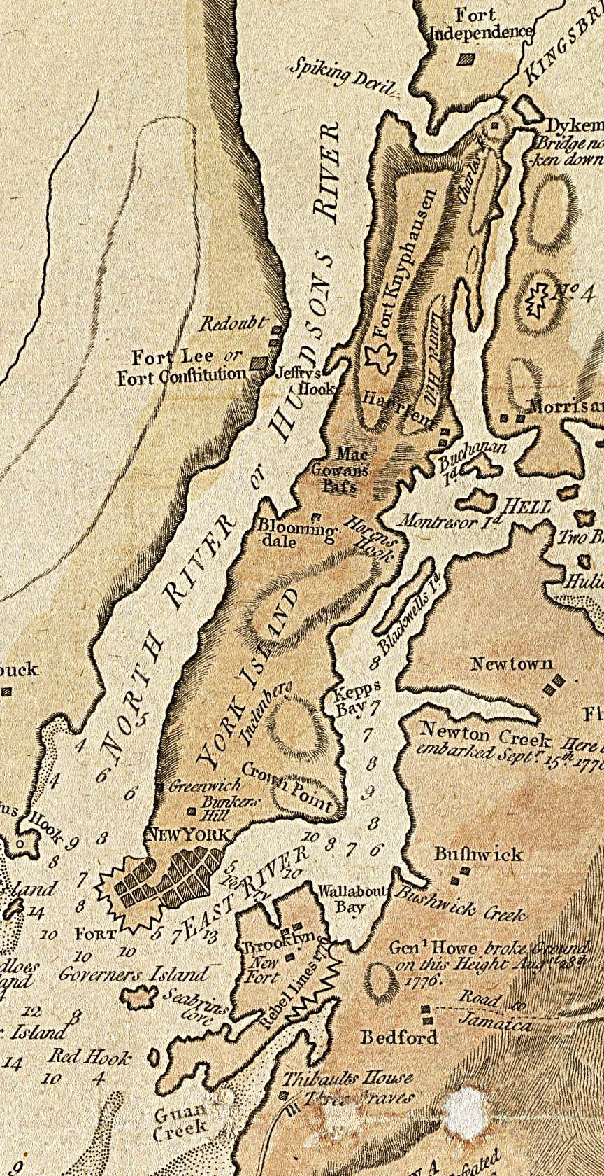
NYC1776 labelled.jpg - Beyond My Ken

A New and correct map of the British colonies in North America comprehending eastern Canada with the province of Quebec, New Brunswick, Nova Scotia, and the Government of Newfoundland, with the (4231157329).jpg - Fæ

A new map of the United States of North America with the British Dominions on that continent &c - by Samuel Dunn, Mathematician; improved from the surveys of Capt. Carver. LCCN2004673324.jpg - Fæ

A map of the British empire in America with the French, Spanish and the Dutch settlements adjacent thereto LOC 2003623107.jpg - Fæ

1719 Carte tres curieuse de la mer du Sud Chatelain.jpg - Natharchives

Homann Regni Mexicani seu Novae Hispaniae, Ludovicianae c.1712-1730 UTA.jpg - Michael Barera

Carte Générale Des Découvertes de l'Amiral de Fonte, et autres Navigateurs Espagnols, Anglois et Russes pour la recherché du (MAPS 92).jpg - BMacZeroBot

Carte Générale Des Découvertes De L'Amiral De Fonte representant la grande probabilité d'un Passage Au Nord Ouest Par Thomas (MAPS 91).jpg - BMacZeroBot

An accurate map of North America describing. .. the British, Spanish and French dominions..., exhibiting the present seat of Wav... also all the West India islands... - by Eman. Bowen ; and John Gibson, engraver... - btv1b530887238.jpg - Gzen92Bot

Nova tabula geographica complectens Borealiorem Americae partem; in qua exacte delineatae sunt Canada sive Nova Francia, Nova Scotia, Nova Anglia, Novum Belgium, Pensylvania, Virginia, Carolina et Terra Nova cum... - btv1b8595994h.jpg - Gzen92Bot

Parties des Considérations géographiques et physiques sur les nouvelles découvertes au nord de la Grande Mer appelée vulgairement la Mer du Sud - btv1b53089399p (02 of 18).jpg - Gzen92Bot

Die Gros-Britannische Colonie-Laender in Nord-America in accuraten Special-Mappen nach den London Originalien getreulich mitgetheilt - btv1b53052915h.jpg - Gzen92Bot