Wikimedi'Òc
Modes d'emploi

Cet album fait partie des albums
Cet album photos contient les sous-albums suivants :


1896 SAL.jpg - Jhw57

Ost und Westpreußen.jpg - Cherubino
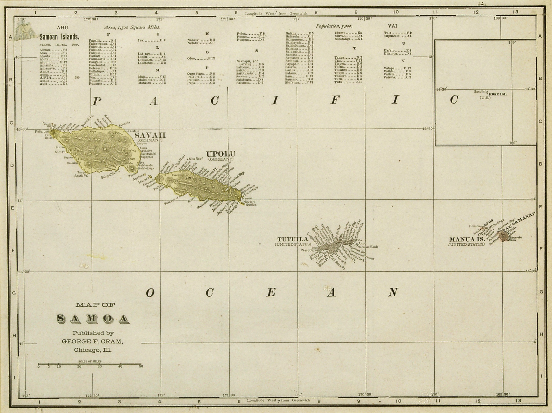
Samoa Cram Map 1896.jpg - Electionworld

VILLETANEUSE Plan 1896.JPG - Claude Villetaneuse

Old Map of San Mateo 1896.jpg - Pepelopex
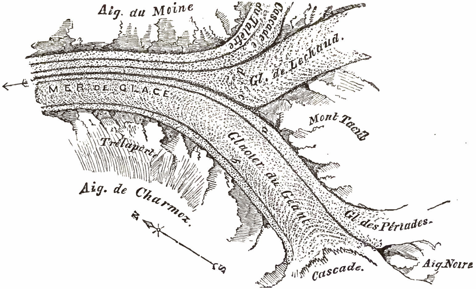
Mer de Glace sketchmap by John Tyndall, 1857, from 1896 edition.png - Cmdrjameson

Clark's grant.jpg - Charles Edward

Puerto Montt 1896 Plano Nicanor Bolona.jpg - WeHaKa

Sarat 1896.jpg - Юрий Майдан

Gelett Burgess - Map of Bohemia 1896.jpg - Binksternet

SELLO.JPG - Pyt

Erlangen Stadtplan 1896 Ausschnitt 001.jpg - Janericloebe

Tyndall 1896 Figure 7-MJ.jpg - DrJunge
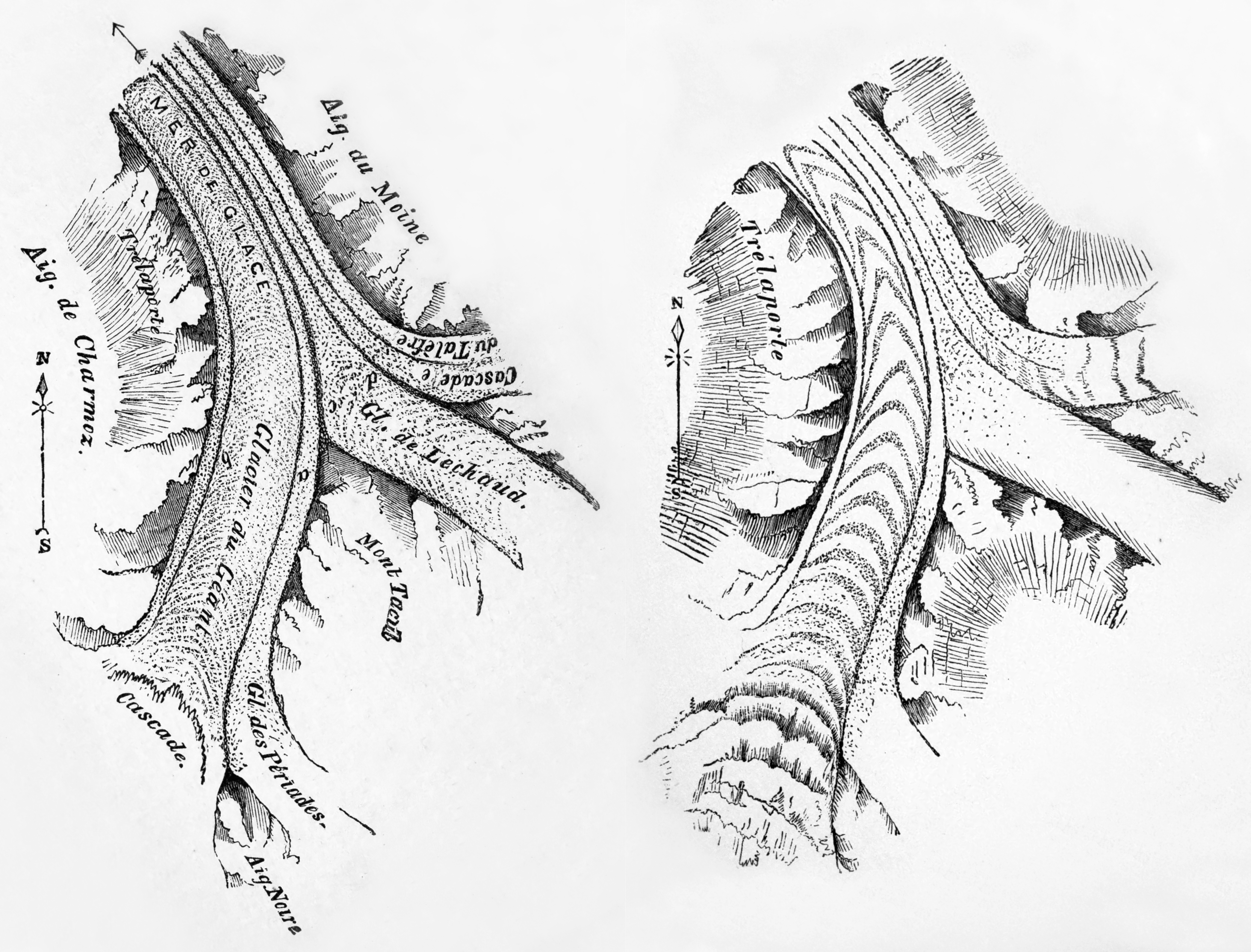
Tyndall 1896 Figure 7-37-MJ2.jpg - DrJunge

Map of Lemuria.jpg - Ctac

Battle of Porto Novo.jpg - Spellcast

Fuerfeld-kirche-plan1898.jpg - TRXX-TRXX

Map of Saint-Dié (Vosges) in 1896.jpg - Aristeas

PSM V48 D222 Map of lake copais and surroundings.jpg - Ineuw

PSM V48 D225 Plan of the wells.jpg - Ineuw

PSM V48 D287 The lands of earth at the end of archaean time.jpg - Ineuw

PSM V48 D500 Comparative areas of zoological parks.jpg - Ineuw

PSM V49 D182 Map of warren gulf great lakes region.jpg - Ineuw

PSM V49 D383 Stages of the ice age in europe.jpg - Ineuw

PSM V49 D179 Map of western end of lake ontario.jpg - Ineuw

PSM V49 D184 Map of the early great lakes.jpg - Ineuw

PSM V49 D381 Stages of the ice age in the us and canada.jpg - Ineuw

PSM V50 D194 Plan of kew gardens.jpg - Ineuw

PSM V50 D475 Languages and dialects surrounding Iberia.jpg - Ineuw

PSM V50 D476 Languages and dialects in the united kingdom.jpg - Ineuw

PSM V50 D602 World cephalic index map.jpg - Ineuw

PSM V50 D611 Europe cephalic index map.jpg - Ineuw
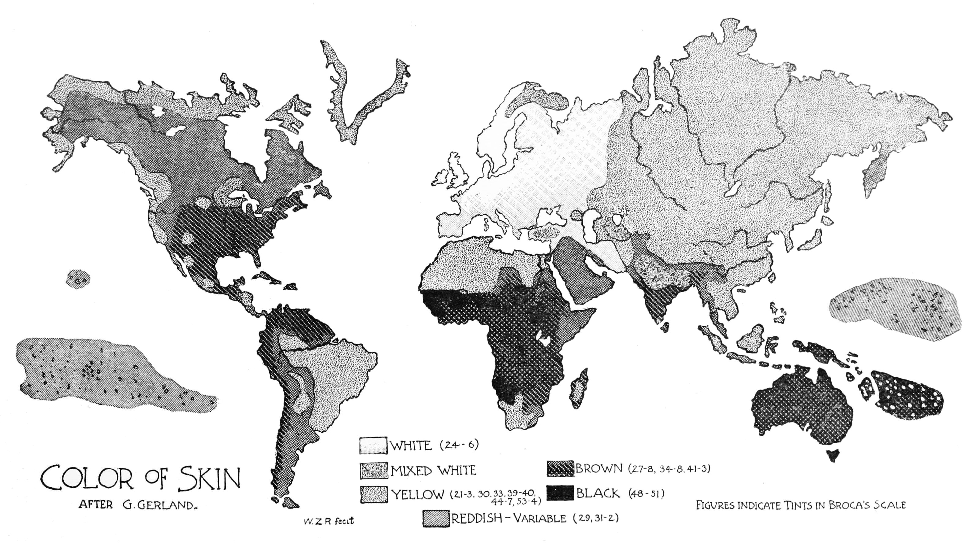
PSM V50 D780 Global map of skin color distribution.jpg - Ineuw

PSM V50 D784 Hair color frequency in europe.jpg - Ineuw

PSM V50 D791 Cranial index map of central europe.jpg - Ineuw

PSM V50 D795 Hair color index in central west europe.jpg - Ineuw

PSM V50 D800 Racial map of central west switzerland.jpg - Ineuw

PSM V51 D026 Global male stature distribution.png - Ineuw

PSM V51 D028 Stature distribution of limousin.png - Ineuw

PSM V51 D030 Stature and health distribution of finisterre.png - Ineuw

PSM V51 D038 Stature distribution of europe.png - Ineuw

PSM V51 D039 Stature distribution of lower brittany.png - Ineuw

PSM V51 D041 Stature distribution of the austrian tyrol.png - Ineuw

CostaAOE1896g.jpg - HCPUNXKID

Karte von Island zu Gretter der Starke.png - Wassermann

The town of Brookline 1896 (9138716720).jpg - File Upload Bot (Magnus Manske)

Map of Quincy (6093644037).jpg - File Upload Bot (Magnus Manske)

Peuple magyar en 1900.jpg - Skblzz1

Mouvement des principales marchandises en France, par période quadriennale.png - PAC2

1896 Eastern Massachusetts street railways map.png - Pi.1415926535

Zemljevid Maribora 1896.jpg - Sporti

Spezialkarte der Österreichisch-ungarischen Monarchie - Rohitsch und Drachenburg 1896.jpg - Sporti

Spezialkarte der Österreichisch-ungarischen Monarchie - Gottschee und Tschernembl 1896.jpg - Sporti

Map of Bedford Township, Michigan, 1896.jpg - Scewing

Topographische Karte 1 25000 Blatt 56 (7020) Leonberg 1896.png - MaxxL

Načrt Kačne jame 1896.jpg - Sporti
Index Map City of Elmira NYPL1575935.tiff - Fæ
Map of Newtown Creek and vicinity - prepared by the Department of Health of Brooklyn, N.Y., January 1896; W.W. Locke, sanitary engineer. NYPL1692889.tiff - Fæ

ELLIOT(1896) Atlantis, Map3.jpg - Metilsteiner

ELLIOT(1896) Atlantis, Map4.jpg - Metilsteiner

Kart over Fridtjof Nansen's Polarexpedition 1893-1896 - no-nb krt 00913.jpg - SteinsplitterBot

BALLINGER(1896) p096 GEOLOGICAL PROFILE.jpg - Metilsteiner

BALLINGER(1896) p095 GEOLOGICAL MAP.jpg - Metilsteiner

A Honfoglalás útja.jpg - Hello world

Karte Zuchtgebiet Vogelsberger Rind.jpg - Hic et nunc

PETER(1896) Die alte Stadtbefestigung (Eisenachs) p35.jpg - Metilsteiner

Königswinter Rheinallee Hauptstraße Plan.jpg - Leit
The Street railway journal (1896) (14575034428).jpg - SteinsplitterBot

Bulletin du Muséum d'histoire naturelle (1896) (20253179659).jpg - SteinsplitterBot

The Canadian record of science (1896) (20344148480).jpg - Fæ

Abhandlungen der Senckenbergischen Naturforschenden Gesellschaft (1896) (16741783516).jpg - SteinsplitterBot

Abhandlungen der Senckenbergischen Naturforschenden Gesellschaft (1896) (16145361684).jpg - SteinsplitterBot

Das Süsswasserplankton; Methode und Resultate der quantitativen Untersuchung (1896) (20219480133).jpg - Fæ

Das Süsswasserplankton; Methode und Resultate der quantitativen Untersuchung (1896) (20217854844).jpg - Fæ

Fridtiof Nansen, 1861-1893 (1896) (14802221063).jpg - SteinsplitterBot

On the deep and shallow water marine fauna of the Kerguelen Region of the Great Southern Ocean (1896) (14782225925).jpg - Fæ

Castine, past and present; the ancient settlement of Pentagöet and the modern town (1896) (14778480082).jpg - Fæ

Our system of government (1896) (14784941753).jpg - Fæ

Church at Home and Abroad, The (Jan. - June 1896) (1896) (14778133792).jpg - SteinsplitterBot

Manchester Historic Association collections (1896) (14802367423).jpg - Fæ

Fridtiof Nansen, 1861-1893 (1896) (14595870127).jpg - Fæ

Historical papers and addresses of the Lancaster County Historical Society (1896) (14772858642).jpg - Fæ

Our system of government (1896) (14762716964).jpg - Fæ

Church at Home and Abroad, The (Jan. - June 1896) (1896) (14778199672).jpg - Fæ

Plan de l'hopital maritime de Pen-Bron. 1896.jpg - Wikineptune

Map of the Balkan States (Miller, William, 1896).jpg - Zoupan

Grieben Neuer Plan von Berlin mit Umgebung 1896.jpg - Alexrk2

L.C. van Panhuys - Kaart van de Beneden-Marowijne (1896).jpg - Fentener van Vlissingen

Carta delle provincie di Massa, Lucca, Pisa e Livorno (1896).jpg - Chiorbone da Frittole
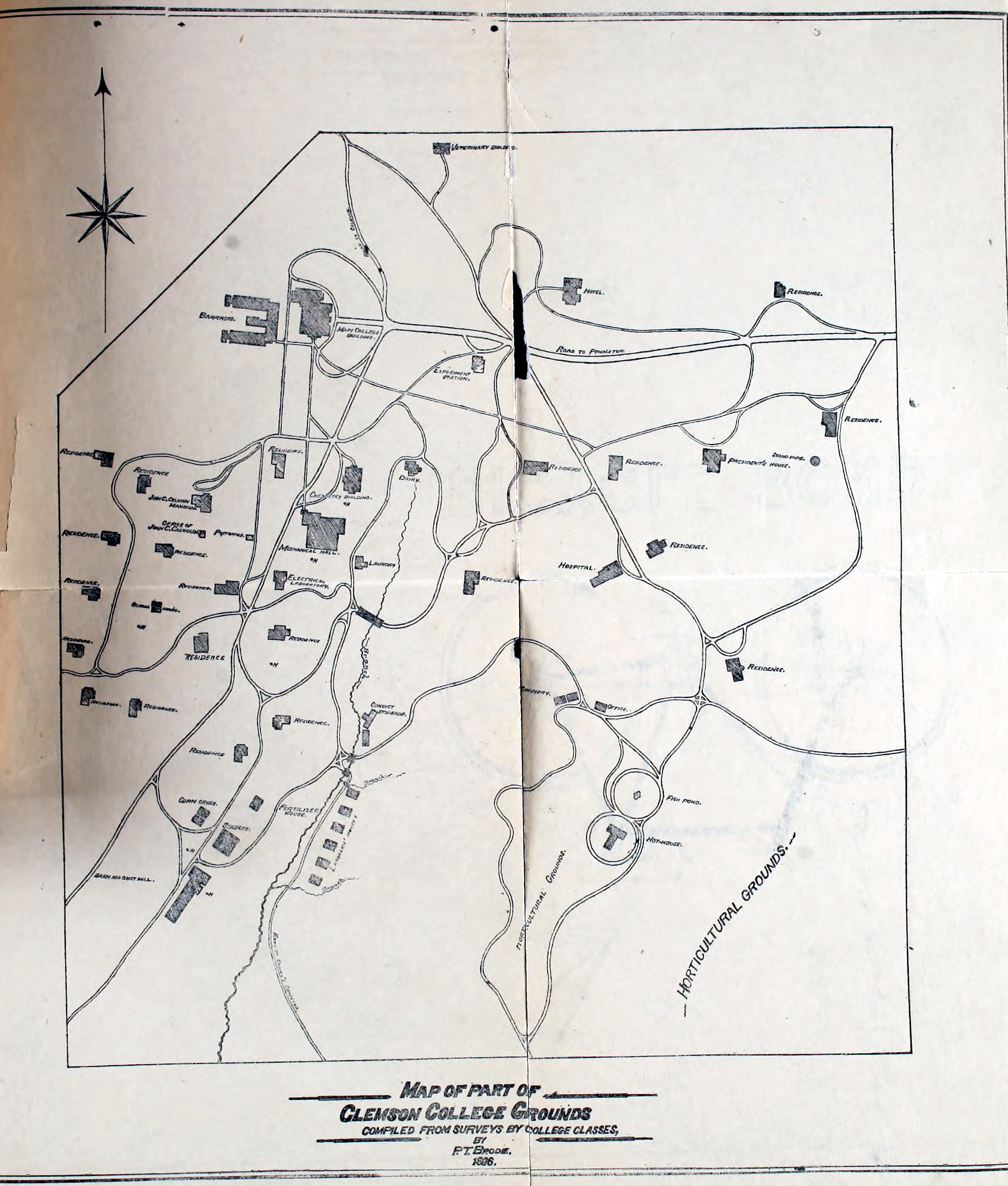
Clemson campus map 1896.png - Spyder Monkey

327 of 'Elementary Physical Geography' (11138301084).jpg - Artix Kreiger 2

12 of 'The Sioux Quartzite and Certain Associated Rocks ... A thesis, etc. (With sketch-maps.)' (11232504263).jpg - FlickreviewR 2
Sanborn Fire Insurance Map from Hyde Park, Lamoille County, Vermont. LOC sanborn08922 001.tif - Fæ

Sanborn Fire Insurance Map from Hyde Park, Lamoille County, Vermont. LOC sanborn08922 001.jpg - Fæ
Map of the Seaboard Air Line and its principal connections north, south, east & west, 1896. LOC 98688799.tif - Fæ

Map of the Seaboard Air Line and its principal connections north, south, east & west, 1896. LOC 98688799.jpg - Fæ
Coal section of Flat-top Mountain LOC 2005625146.tif - Fæ

Coal section of Flat-top Mountain LOC 2005625146.jpg - Fæ
Roberts' road map of the District of Columbia and adjoining portions of Maryland and Virginia. LOC 88693356.tif - Fæ

Roberts' road map of the District of Columbia and adjoining portions of Maryland and Virginia. LOC 88693356.jpg - Fæ
Map of China and the surrounding regions LOC 2006458366.tif - Fæ
Section of coal beds in Flat-top Mountain LOC 2005625147.tif - Fæ

Section of coal beds in Flat-top Mountain LOC 2005625147.jpg - Fæ

A topographical map of Morehouse Parish, La. - being a general revision of old maps LOC 2012592304.jpg - Fæ
Map of Colbert County, Alabama LOC 2011590022.tif - Fæ
Eisenbahn-Karte von Mittel-Europa - mit Angabe sämtlicher Bahnstationen, Hauptpost- und Dampfschiffahrts-Verbindungen LOC 2008620957.tif - Fæ

Eisenbahn-Karte von Mittel-Europa - mit Angabe sämtlicher Bahnstationen, Hauptpost- und Dampfschiffahrts-Verbindungen LOC 2008620957.jpg - Fæ
Ashtabula Harbor, Ohio 1896. LOC 75694910.tif - Fæ

Map of the town of Newtown, Queens Co., N.Y. LOC 2004627122.jpg - Fæ

Missions Catholiques De La Melanesie, Micronesie et Polynesie (Oceanie).jpg - Pemu

Missions Catholiques De La Melanesie, Micronesie et Polynesie (Oceanie) 50 Prozent verkleinert.jpg - Pemu

Missions Catholiques De La Melanesie, Micronesie et Polynesie (Oceanie) brighter.jpg - Pemu

Fatuhiva - from Missions Catholiques De La Melanesie, Micronesie et Polynesie (Oceanie) 50 Prozent verkleinert (cropped).jpg - Ratzer

Hiva Oa-Tahuata-Mohotane - from Missions Catholiques De La Melanesie, Micronesie et Polynesie (Oceanie) 50 Prozent verkleinert (cropped).jpg - Ratzer

Nuku Hiva - from Missions Catholiques De La Melanesie, Micronesie et Polynesie (Oceanie) 50 Prozent verkleinert (cropped).jpg - Ratzer

Ua Pou - from Missions Catholiques De La Melanesie, Micronesie et Polynesie (Oceanie) 50 Prozent verkleinert (cropped).jpg - Ratzer
Map of Morris County, New Jersey. LOC 2019585056.tif - Fæ

Handkarte des Gerzogthumes Bukowina & Czernowitz.jpg - Accipiter Gentilis Q.

Submarine cables of the world, 1896.jpg - Babelia

Terre Sainte.Itinéraire au jour le jour de notre pèlerinage aux lieux saints (FL37124168 3899504).jpg - Geagea

Rand McNally & Co's New 14 x 21 Map of Palestine (FL37128321 3904736).jpg - Geagea

Edward Weller, Map of Syria with Crusading names (FL79614835 3769497).jpg - Geagea
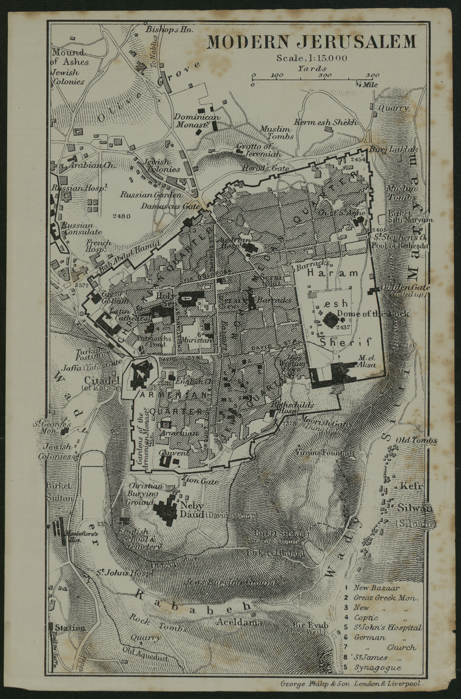
Modern Jerusalem (FL4542177 3478636).jpg - Geagea

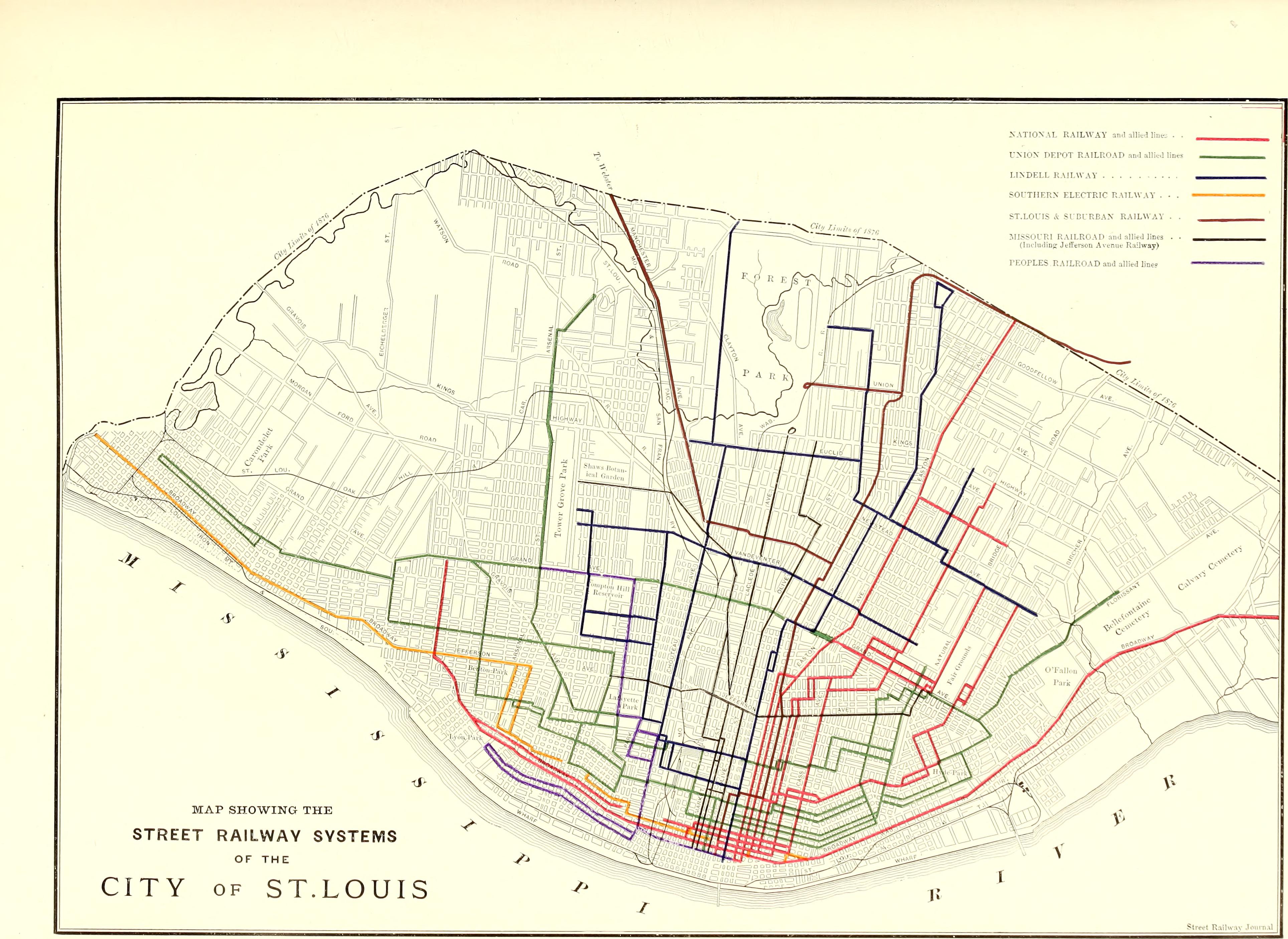
Map Showing The Street Railway Systems of the City of St. Louis, 1896.jpg - DontCallMeLateForDinner