Wikimedi'Òc
Modes d'emploi

Cet album fait partie des albums
Cet album photos contient les sous-albums suivants :


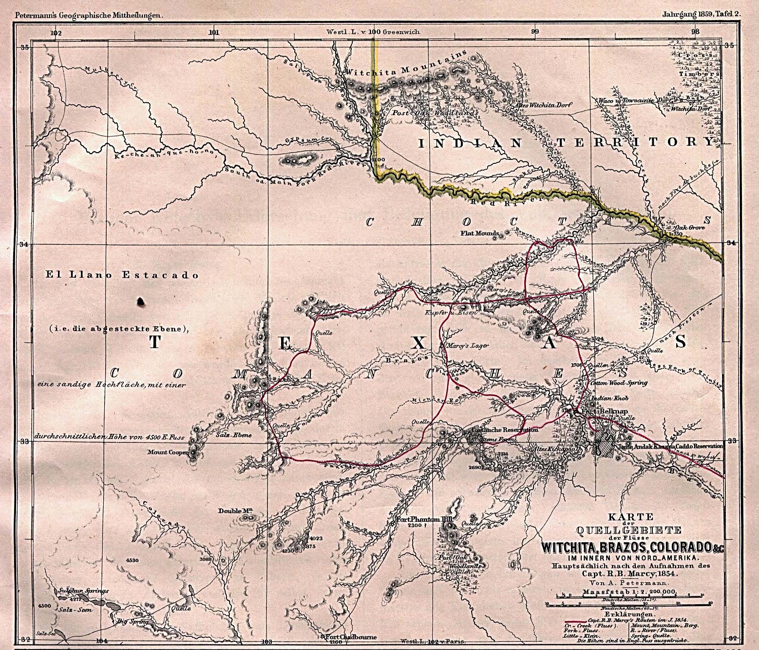
Texas Rivers 1895.jpg - Exdaix
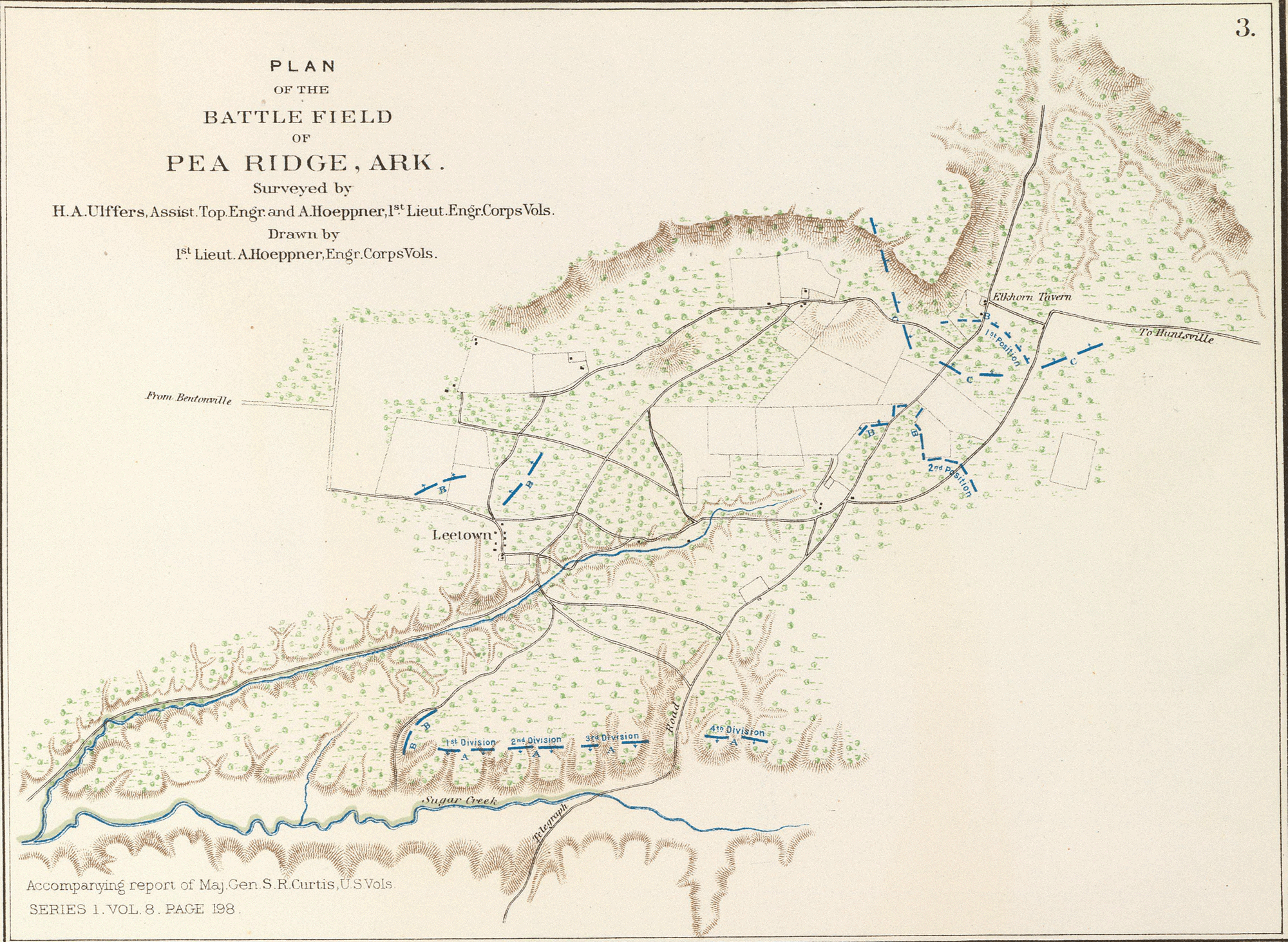
Battle of Pea Ridge 1.png - ¡0-8-15!
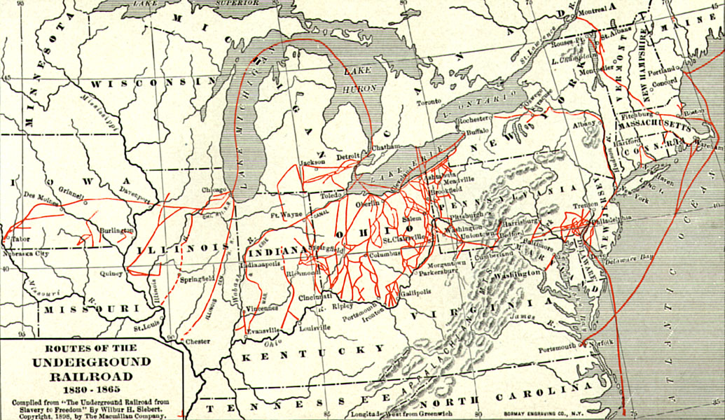
Undergroundrailroadsmall2.jpg - Jengod
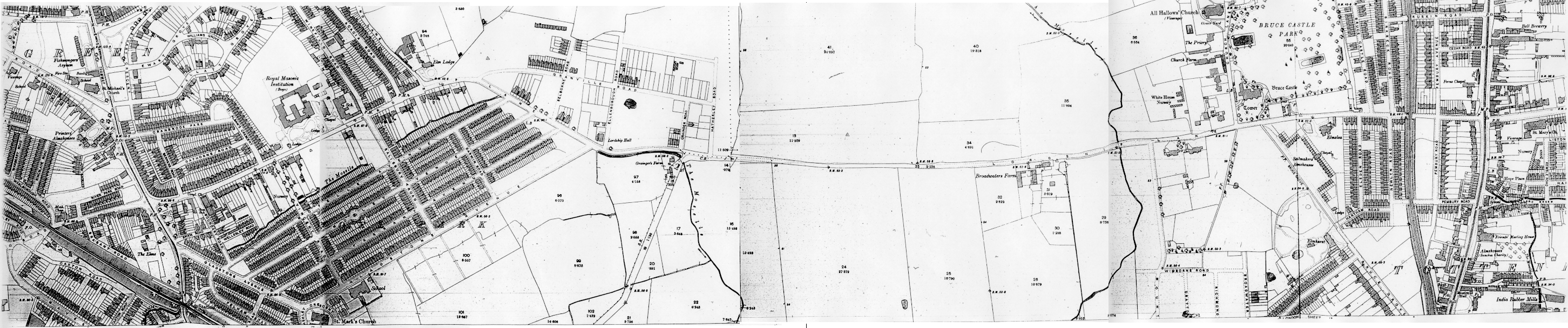
OS Edition2 1895 25inch map of Lordship Lane N17 and N22.png - Lcarsdata

Cotroceni harta 1895.jpg - Bogdan

Battle of Bentonville map.png - Ras67

Austria-Hungary (ethnic).JPG - Olahus

Exclave hemmeres.jpg - Kallewirsch
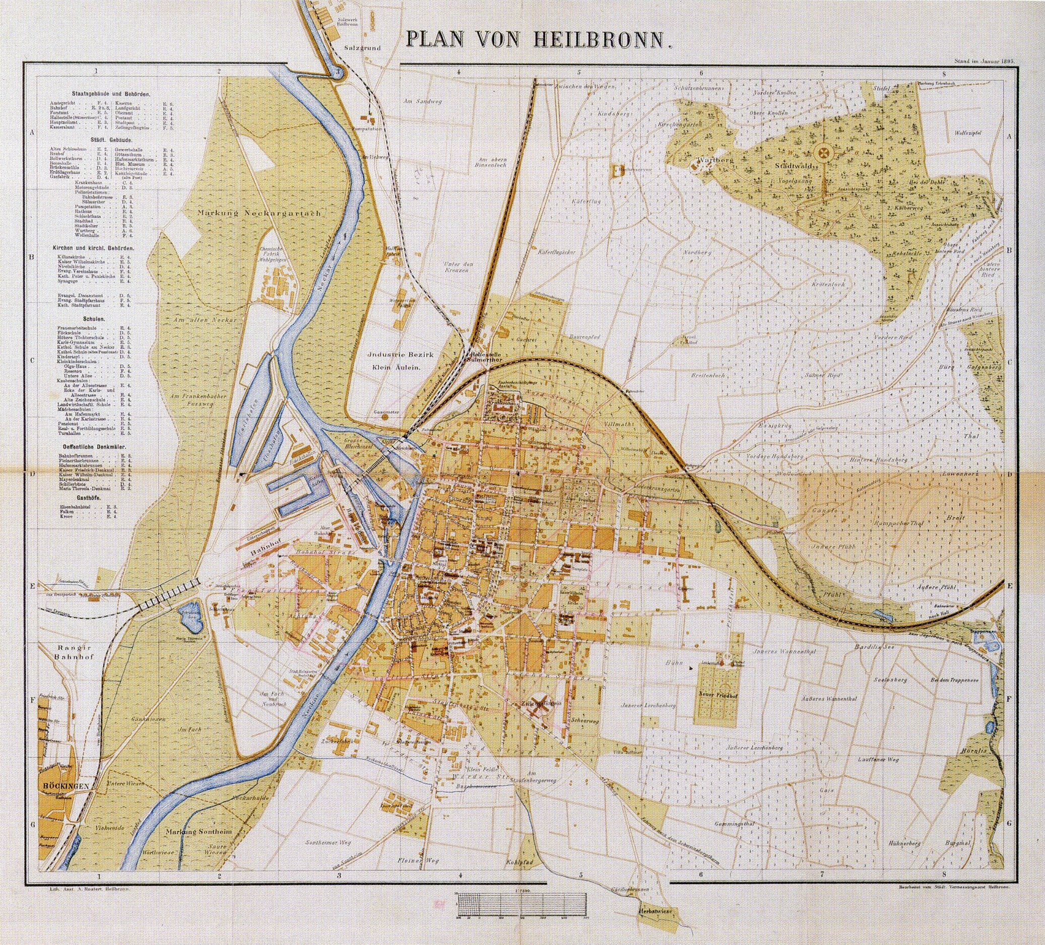
Plan der Stadt Heilbronn von 1895.jpg - Messina

Albany Bleecker Stadium.jpeg - MattWade

'Propeller Island' by Léon Benett 37.jpg - Electron

Wallace Island Life p276.png - Keith Edkins

Wallace Island Life p277.png - Keith Edkins

Wallace Island Life p333.png - Keith Edkins

1895 Bacon's Pocket Map of the Environs of London, England - Geographicus - London-bacon-1895.jpg - BotMultichillT

1895 Barthholomew Cyclist's Map of 50 Miles Around London, England - Geographicus - London50Miles-bartholomew-1895.jpg - BotMultichillT
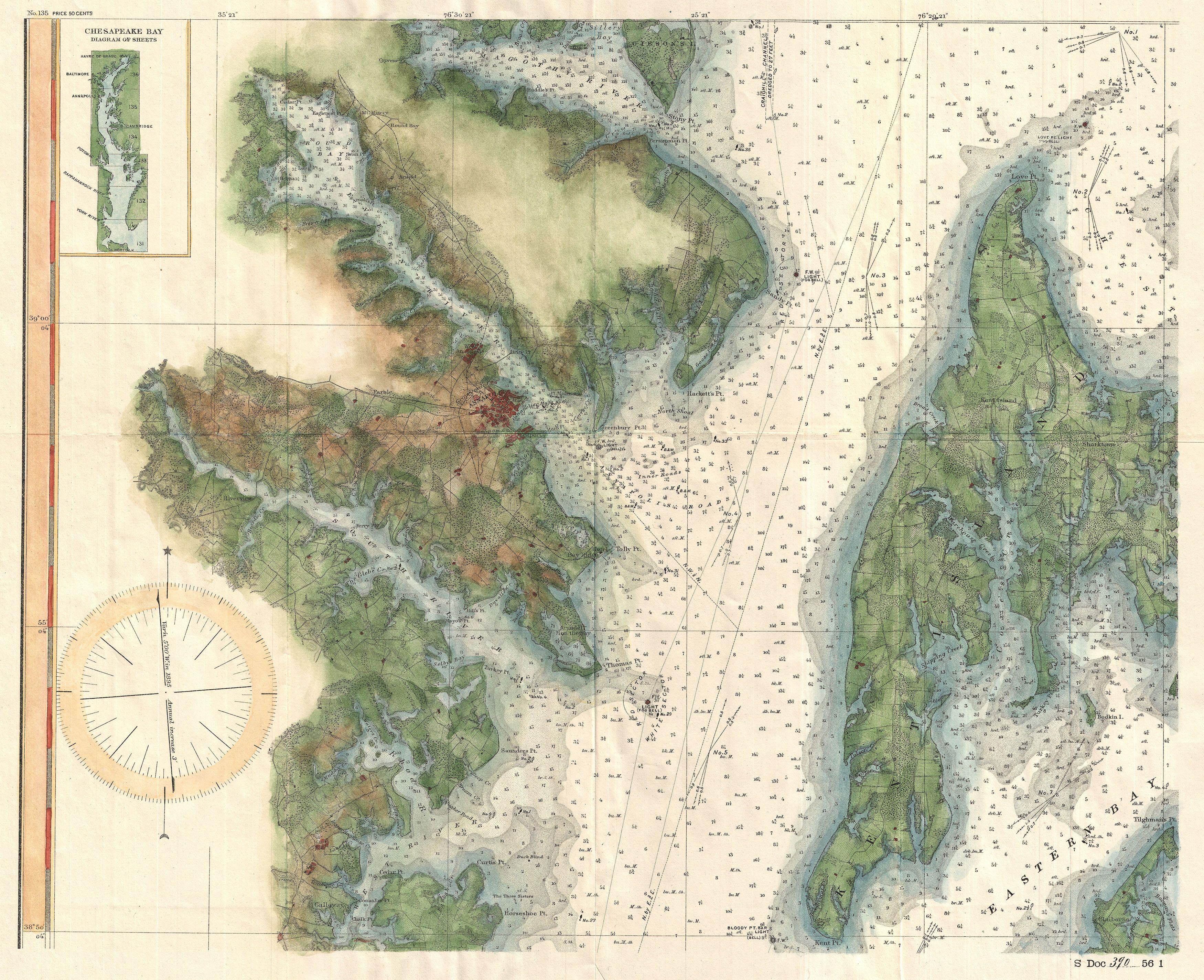
1895 U.S. Coast Survey Map of the Chesapeake Bay around Annapolis - Geographicus - ChesapeakeBayAnnapolis-uscs-1895.jpg - BotMultichillT

1895 Meiji 28 Japanese Map of Imperial Japan with Taiwan - Geographicus - ImperialJapan-meiji28-1895.jpg - BotMultichillT

Knoxville-tennessee-1895-tn1.jpg - BrineStans

Delaware1895.jpg - Pauk

KaartGoudkust1865.jpg - Fentener van Vlissingen

Grube Astraea Juntersdorf - Ausschnitt Meßtischblatt 3093 Zülpich (1895).png - Tetris L

Dianaburg Darmstadt map pre1898.JPG - Kallewirsch

Lesconil-en-Poulan 1895.png - Piero~commonswiki

Plăşile judeţuluĭ (Ilfov).jpg - Dahn

Imprejurimile oraşuluĭ Bucureştĭ.jpg - Dahn

Imprejurimile Comuneĭ Olteniţa.jpg - Ras67

Karte Engadin Grieben mit markierten Paessen.jpg - ONAR
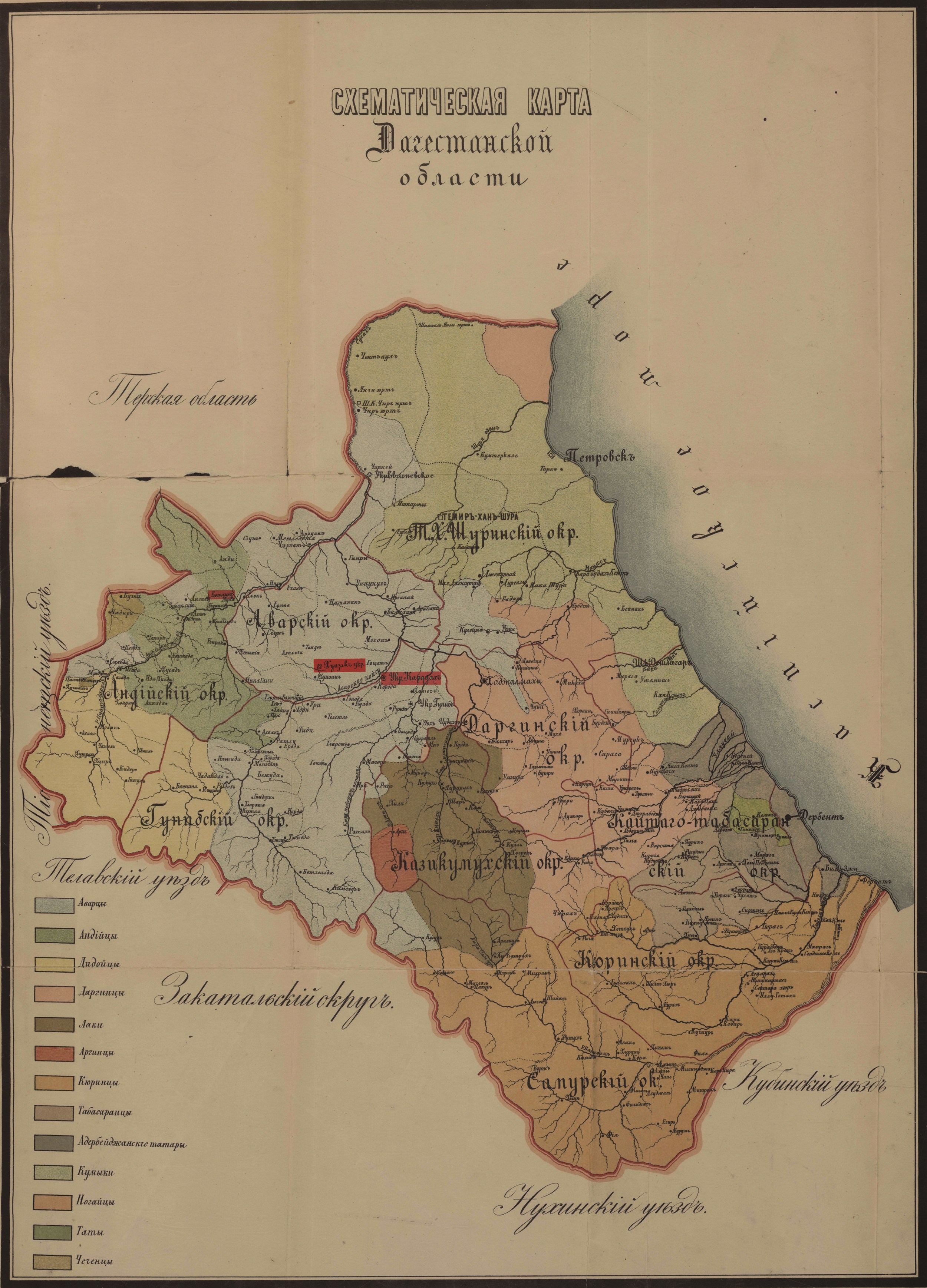
Daghestan ethnographic and administrative map 1895.jpg - Bogomolov.PL

Denèfle-et-Cie.svg - Trizek

Denèfle-et-Cie.png - Trizek
Karte Osterholz (Wuppertal) 1895.jpg - Epsolin~commonswiki

Carte topographique du département de Paris et de ses environs - 18?? - btv1b84424161.jpg - PierreSelim

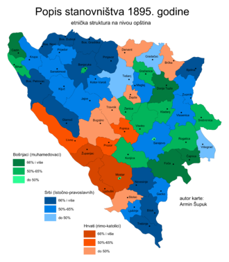
Etnička struktura Bosne i Hercegovine 1895. godine.png - BošnjakArmin

Topographical map of Blue Hills Reservation (9471060059).jpg - File Upload Bot (Magnus Manske)
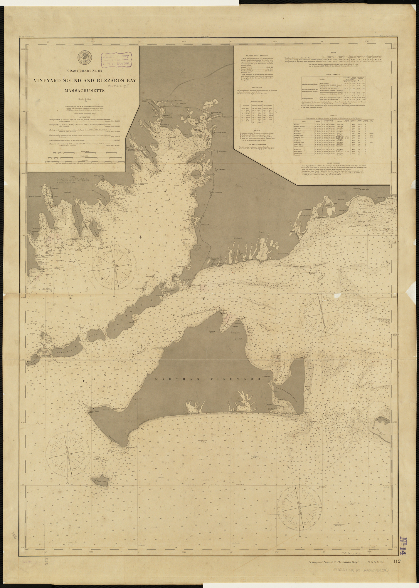
Vineyard Sound and Buzzards Bay, Massachusetts (3120842366).jpg - File Upload Bot (Magnus Manske)

Buenos Aires - Plano de Basch (1895).jpg - Fma12

Messtischblatt 4209 Haltern 1895.jpg - Elop

Messtischblatt 4209 Haltern 1895 Rechteck.jpg - Elop

Hillesheim Messtischblatt df dk 0010001 5706 1895.jpg - Cmuelle8

Messel Messtischblatt df dk 0010001 6018 1914.jpg - Cmuelle8
Atlas of the State of New York Prepared under the direction Joseph R. Bien, E.M. Civil and Topographical Engineer from original surveys and various local surveys revised and corrected. based on the NYPL2056490.tiff - Fæ
Explanations NYPL3883784.tiff - Fæ
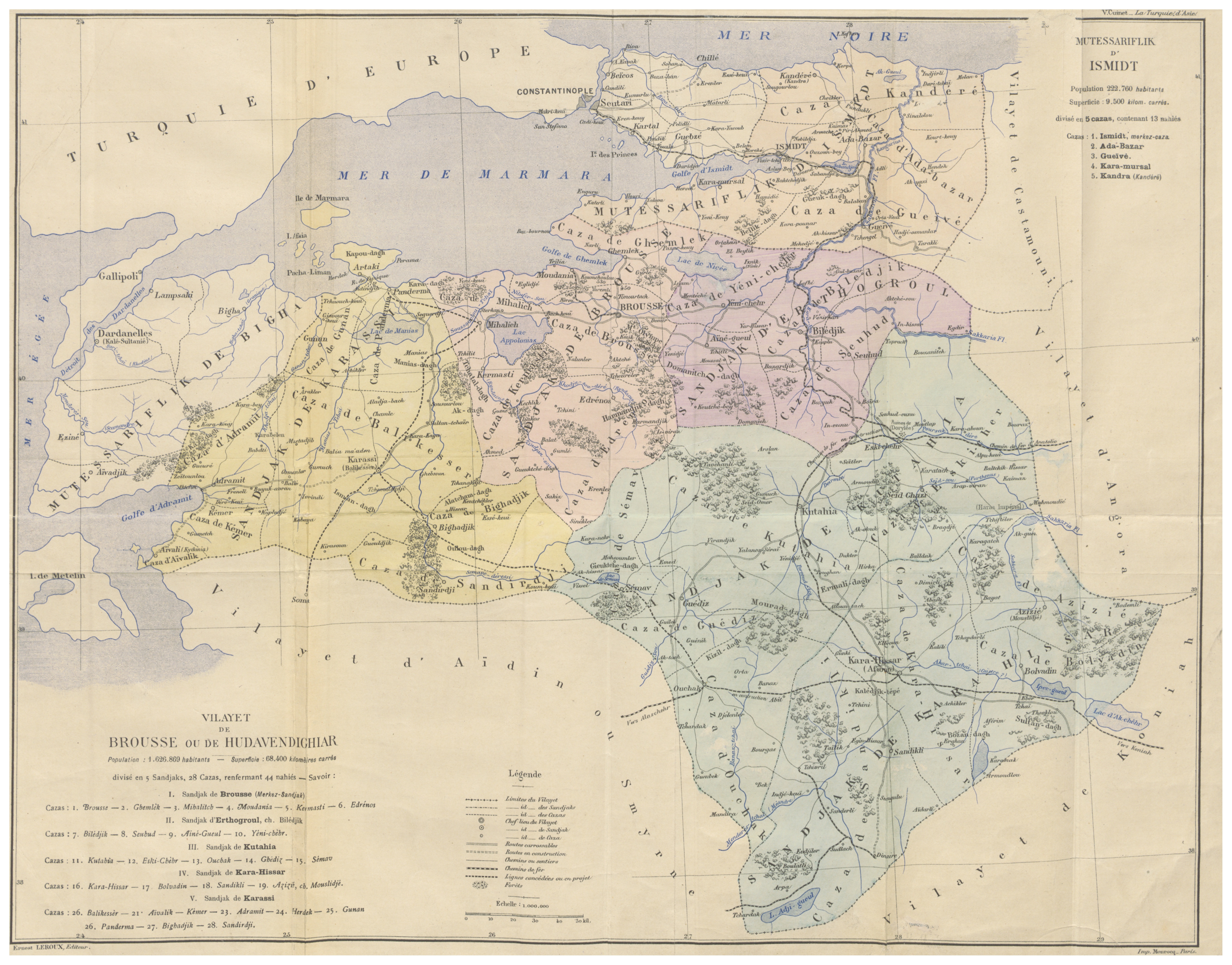
CUINET(1895) 4.017 Vilayet of Hüdavendigâr.jpg - Metilsteiner

CUINET(1895) 4.615 Vilayet of Istanbul.jpg - Metilsteiner

CUINET(1895) 4.418 Vilayet of Kastamonu.jpg - Metilsteiner
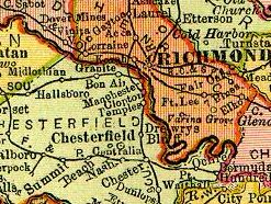
Va 1895 granite.jpg - Deadstar
Warwick county va 1895.jpg - Deadstar

1856 hafen harburg 300dpi.jpg - AltSylt

1894 hafen harburg 300dpi.jpg - AltSylt

ROQUES(1892) p009 Fig.1.jpg - Metilsteiner

ROQUES(1892) p035 Fig.11.jpg - Metilsteiner

ROQUES(1892) p040 Fig.12.jpg - Metilsteiner

ROQUES(1892) p050 Fig.17.jpg - Metilsteiner

ROQUES(1892) p055 Fig.19.jpg - Metilsteiner

Sitte Camillo.jpg - Muzeum umeni

PELHAM(1895) p166 MAP 2.jpg - Metilsteiner

PELHAM(1895) p328 MAP 3.jpg - Metilsteiner

PELHAM(1895) p087 MAP 1.jpg - Metilsteiner
PELHAM(1895) p496 MAP 4.jpg - Metilsteiner

Barnaul 1895.jpg - Well-Informed Optimist

Köln - Römerpark Entwurf 1895 Kowallek, RBA.jpg - Wdwdbot

Wilsons Creek.jpg - Storkk

Annual report of the Bureau of American Ethnology to the Secretary of the Smithsonian Institution (1895) (18741670363).jpg - SteinsplitterBot

Annual report of the Bureau of American Ethnology to the Secretary of the Smithsonian Institution (1895) (19366309251).jpg - SteinsplitterBot

Annual report of the Bureau of American Ethnology to the Secretary of the Smithsonian Institution (1895) (18738992234).jpg - Fæ

Annual report of the Bureau of American Ethnology to the Secretary of the Smithsonian Institution (1895) (18738751454).jpg - SteinsplitterBot

Annual report of the Bureau of American Ethnology to the Secretary of the Smithsonian Institution (1895) (18738478014).jpg - Fæ

Karta slobodskykh kazachjikh polkov 1764.jpeg - Well-Informed Optimist

Bulletin - Biological Survey (1895) (20435208051).jpg - Fæ

Bulletin - Biological Survey (1895) (20240902990).jpg - SteinsplitterBot
Bulletin - Biological Survey (1895) (20435168241).jpg - Fæ

The River Congo from its mouth to Bólobó; with a general description of the natural history and anthropology of its western basin (1895) (14783891223).jpg - JMK
T-2265B.jpg - Sanjayshivesh

1895 Revised general plan for Jackson Park.jpg - Scewing

Agnes Cottons homes.jpg - Victuallers

Ciudad Lineal-perfil.jpg - Latemplanza

Map of Chickamauga and Chattanooga National Park (10839206445).jpg - Fæ

165 of 'Geschichte des Schlosses, der Herrschaft und der Stadt Forbach, etc' (11135166933).jpg - Artix Kreiger 2
165 of 'Geschichte des Schlosses, der Herrschaft und der Stadt Forbach, etc' (11136309596).jpg - Artix Kreiger 2

26 of 'The Sioux Quartzite and Certain Associated Rocks ... A thesis, etc. (With sketch-maps.)' (11230328266).jpg - SteinsplitterBot

Euston Square area, Ordnance Survey map 1895.jpg - Philafrenzy
Antietam battlefield. Preliminary map no. 3. LOC 99447376.tif - Fæ

Antietam battlefield. Preliminary map no. 3. LOC 99447376.jpg - Fæ
Bicycle road-map - New Haven, Connecticut, to New London, Connecticut. LOC 2010592716.tif - Fæ

Bicycle road-map - New Haven, Connecticut, to New London, Connecticut. LOC 2010592716.jpg - Fæ
Antietam battlefield - preliminary map no. 3 LOC 2005625021.tif - Fæ

Antietam battlefield - preliminary map no. 3 LOC 2005625021.jpg - Fæ
Map of Chattanooga and environs. Copyright 1895 by W. E. Birchmore. Engraved by Buff(alo) Elec. & Eng. Co. LOC 99448839.tif - Fæ

Map of Chattanooga and environs. Copyright 1895 by W. E. Birchmore. Engraved by Buff(alo) Elec. & Eng. Co. LOC 99448839.jpg - Fæ
Sketch of a portion of the Antietam battlefield, north of Sharpsburg, in the area of the West Wood, North Wood, and East Wood. LOC 2005625023.tif - Fæ

Sketch of a portion of the Antietam battlefield, north of Sharpsburg, in the area of the West Wood, North Wood, and East Wood. LOC 2005625023.jpg - Fæ

Chickamauga Battlefield LOC 79691613.jpg - Fæ
Yellowstone National Park boundaries. LOC 97683574.tif - Fæ

Yellowstone National Park boundaries. LOC 97683574.jpg - Fæ
The Wilderness, May 5 & 6, 1864. LOC 99448349.tif - Fæ

The Wilderness, May 5 & 6, 1864. LOC 99448349.jpg - Fæ
Laing's Planetarium LOC 2006458006.tif - Fæ

Laing's Planetarium LOC 2006458006.jpg - Fæ
Sketch of a portion of the Antietam battlefield, north of Sharpsburg, in the area of the West Wood, North Wood, and East Wood. LOC 2005625024.tif - Fæ

Sketch of a portion of the Antietam battlefield, north of Sharpsburg, in the area of the West Wood, North Wood, and East Wood. LOC 2005625024.jpg - Fæ
Map showing the location of battle fields of Virginia LOC 99448894.tif - Fæ

Map showing the location of battle fields of Virginia LOC 99448894.jpg - Fæ
Southwest, or no. 2, sheet of preliminary map of Antietam (Sharpsburg) battlefield. Enlarged from "Michler" map of the war records atlas with corrections and additions LOC 99447389.tif - Fæ

Southwest, or no. 2, sheet of preliminary map of Antietam (Sharpsburg) battlefield. Enlarged from "Michler" map of the war records atlas with corrections and additions LOC 99447389.jpg - Fæ

Western Route to China. East India Archipelago LOC 2006629782.jpg - Fæ
Carte de l'Indo-Chine LOC 2008621654.tif - Fæ

Carte de l'Indo-Chine LOC 2008621654.jpg - Fæ

(Topographic map of Washington D.C. region) LOC 88693358.jpg - Fæ

Chickamauga battlefield. Accompanies The battle of Chickamauga. Historical map and guide book. LOC 99447310.jpg - Fæ

Large-scale-detailed-old-map-of-palestine-during-the-monarchy-1895.jpg - Thesupermat
Yellowstone National Park, Northern Pacific Railroad. LOC 97683606.tif - Fæ

Yellowstone National Park, Northern Pacific Railroad. LOC 97683606.jpg - Fæ
Tennessee-North Carolina. LOC 99446177.tif - Fæ

Tennessee-North Carolina. LOC 99446177.jpg - Fæ

Chickamauga battlefield. (Sept 19-20, 1863) LOC 99447309.jpg - Fæ
Township and sectional map of Mobile County, State of Alabama - compiled and drawn from the most reliable and recent data - showing the railroads, public roads, school houses, Old Spanish & other LOC 2011590019.tif - Fæ

Township and sectional map of Mobile County, State of Alabama - compiled and drawn from the most reliable and recent data - showing the railroads, public roads, school houses, Old Spanish & other LOC 2011590019.jpg - Fæ
(Guatemala-boundary-Mexico). LOC 86693877.tif - Fæ

(Guatemala-boundary-Mexico). LOC 86693877.jpg - Fæ

Mapa dos caminhos de ferro em Portugal 1895 - Sul e Sueste.jpg - Ajpvalente
Map of the republic of Guatemala LOC 2007627461.tif - Fæ

Map of the republic of Guatemala LOC 2007627461.jpg - Fæ

Rotuma map in Australian Science Journal 1895.jpg - Ratzer
Western Route to China. Chart no.4, East India Archipelago LOC 2006629782.tif - Fæ

Western Route to China. Chart no.4, East India Archipelago LOC 2006629782.jpg - Fæ
1895 French atlas - Atlas de Géographie physique, politique, économique, géologique, éthnographique.pdf - Balkanique
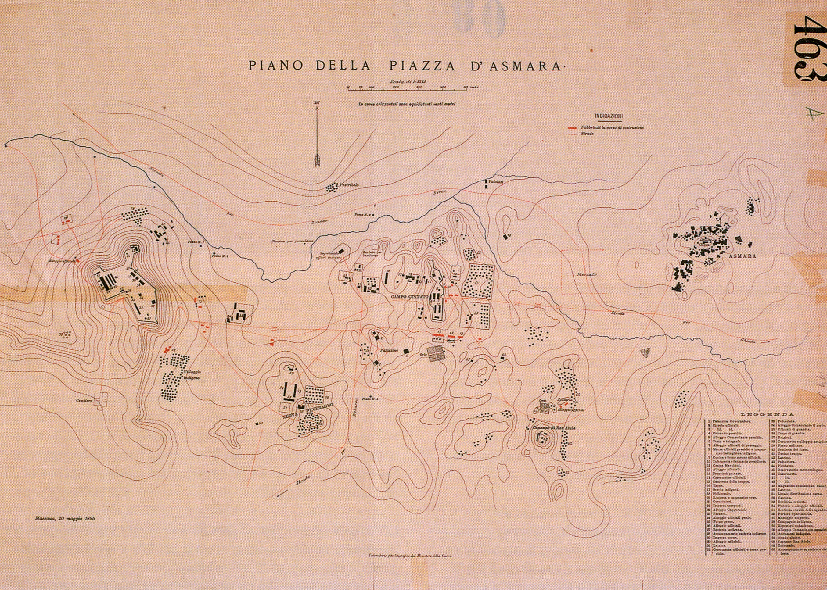
Map of Asmara in 1895.jpg - JanNeysan
Louisville and Nashville Railroad Depot in November 1895 detail, from- Sanborn Fire Insurance Map from Pulaski, Giles County, Tennessee. LOC sanborn08365 003-6 (cropped).tif - Tibet Nation
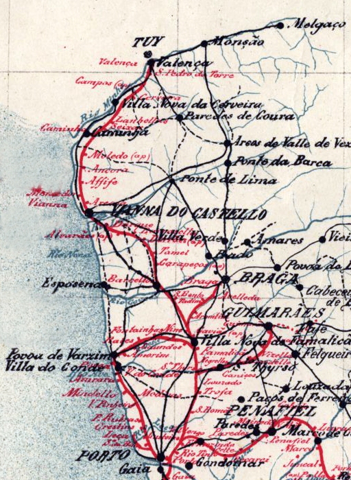
Mapa dos caminhos de ferro em Portugal 1895 - Rede do Minho.jpg - Ajpvalente
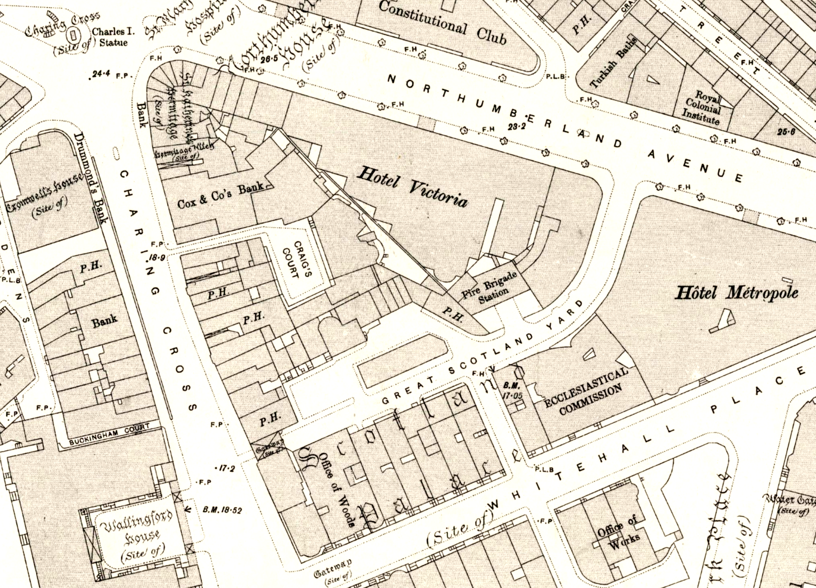
Craig's Court area map 1895.png - Philafrenzy
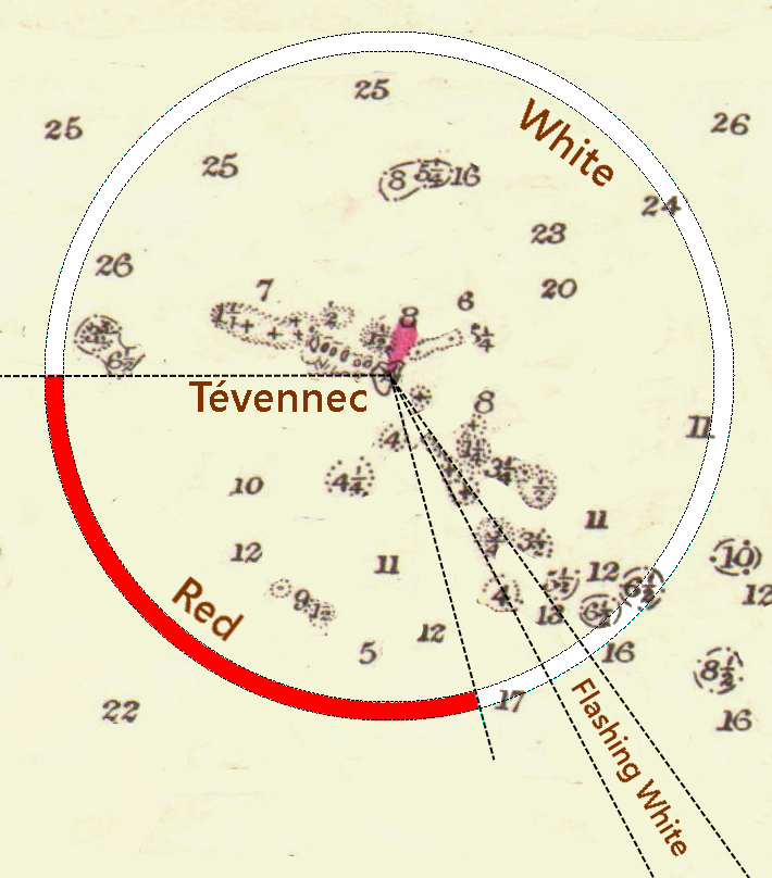
Tevennec sectors 1895.png - Kognos

Crystal Palace High Level plan 1895.png - Swiveler

River Thames. From Westminster to Cross Ness. International geographical Congress, July 31 st, 1895. Visit to the Docks - btv1b530621597.jpg - Gzen92Bot

Tripoli–Murzuk–Lake Chad route map by Monteil 1895.jpg - Jengod

French Service géographique de l'armée, Carte de la Tunisie (FL13727116 2498335).jpg - Geagea

Ante-proyecto para el trazado de Granjas en el campo propiendad del Fomento Agrario Israelita Argentino S.A.Estacion Gowland F.C.O. Aqote F.C.P (FL155947974 3940952).jpg - Geagea

Ashburnham Libri map - ZDPV printed version of inscriptions (FL169299418 0898347).jpg - Geagea

Plan von Jerusalem nach dem in Munchen befindlichen Original aus der 2tem Halfte des XV Jahrhunderts (FL169318446 0898357).jpg - Geagea

Matthew Paris, Matthew Paris map of Palestine - ZDPV printed version of inscriptions. Geograph. Anstalt von Wagner & Debes Leipzig (FL169642148 0898357).jpg - Geagea
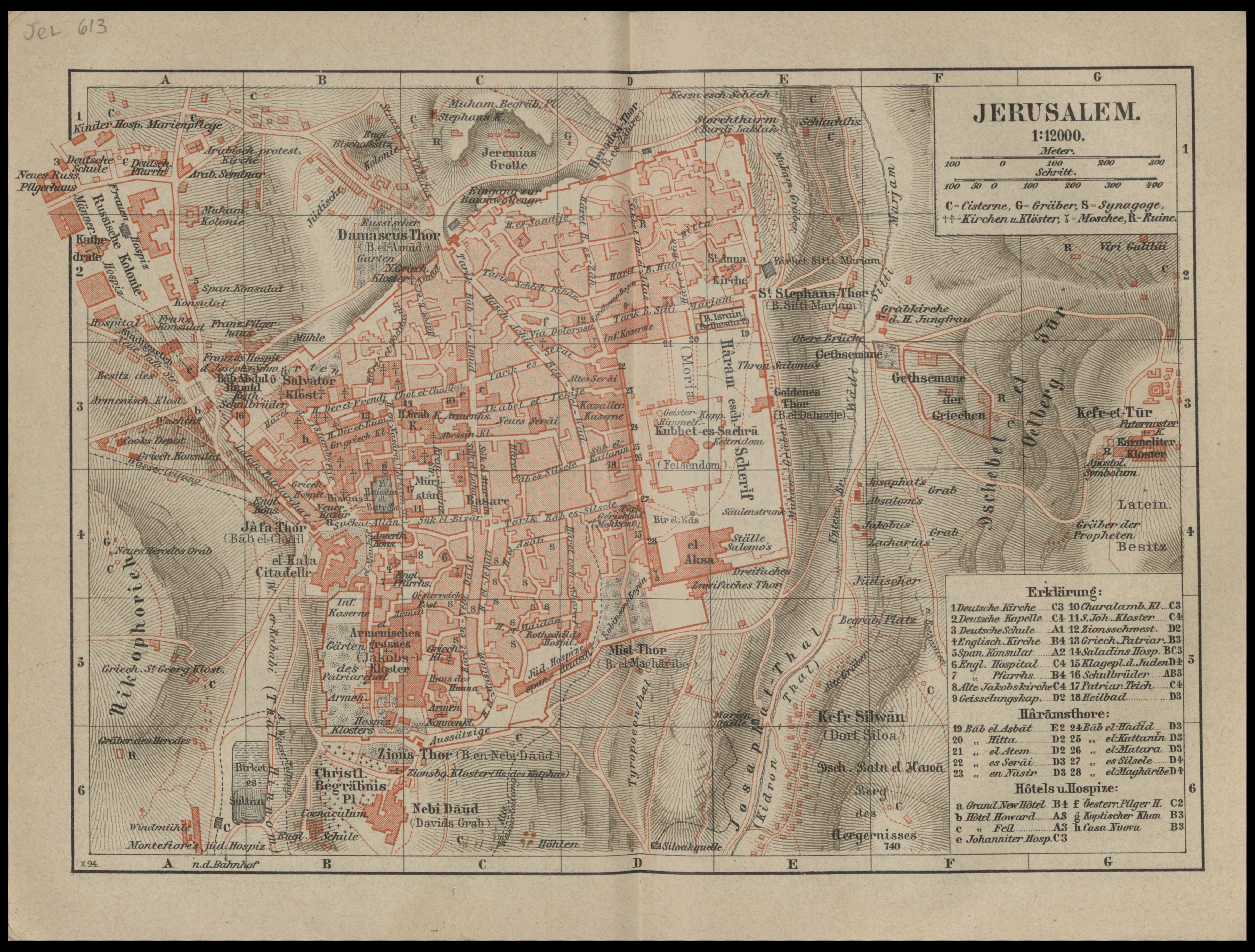
Jerusalem (FL198245525 1143541).jpg - Geagea

Hermann Guthe, Palästina.Zur zeit der entstehung des Israelitischen königtums (FL33144849 3882716).jpg - Geagea

Modern Jerusalem (FL35098789 3892753).jpg - Geagea

Judea. The Shephelah and Philistia (FL36567105 3906796).jpg - Geagea

W. & A. K. Johnston, The Holy Land as allotted by Joshua.to the Twelve Tribes of Israel (FL37129711 3912028).jpg - Geagea

Map of Bible lands (FL37821352 3923032).jpg - Geagea

Map of Bible lands (FL37821471 3923037).jpg - Geagea

Plan de la ville d'Odessa en 1814 (FL39696843 3714559).jpg - Geagea

Plan von Jafa (FL46962459 3932222).jpg - Geagea

Jerusalem (FL45595643 3932208).jpg - Geagea

Nazareth (FL45595654 3932218).jpg - Geagea

Palästina (FL45595669 3932180).jpg - Geagea

Jerusalem nahere umgebung (FL45595684 3932215).jpg - Geagea