Wikimedi'Òc
Modes d'emploi

Cet album fait partie des albums
Cet album photos contient les sous-albums suivants :


1891 Poor's Delaware, Lackawanna and Western Railroad.jpg - NE2
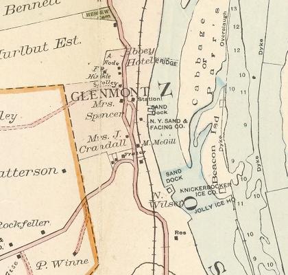
GlenmontNY1891map.jpg - VanishedUser 23asdsalkaka

1891 Long Island Railroad Real Estate Map of Long Island - Geographicus - LongIsland-railroadmap-1891.jpg - BotMultichillT
Atlas of the city of Buffalo, New York. From official records, private plans and actual surveys. Surveyed and Published under the direction of G.M. Hopkins, C.E., 302 Walnut St., Philadelphia. 1891. NYPL2055415.tiff - Fæ
Buffalo, Double Page Plate No. 10 (Map bounded by Summer St., Main St., Allen St., West Ave.) NYPL2055426.tiff - Fæ
Buffalo, Double Page Plate No. 11 (Map bounded by North St., Jefferson St., Genesee St., Goodell St., Main St.) NYPL2055427.tiff - Fæ
Buffalo, Double Page Plate No. 12 (Map bounded by Michigan St., Keane St., Hickory St., Eagle St.) NYPL2055428.tiff - Fæ
Buffalo, Double Page Plate No. 13 (Map bounded by Packham St., Fillmore Ave., E. Eagle St., Hickory St.) NYPL2055429.tiff - Fæ
Buffalo, Double Page Plate No. 15 (Map bounded by Wabash St., Hamburg Canal, Katharine St., Buffalo River) NYPL2055431.tiff - Fæ
Buffalo, Double Page Plate No. 17 (Map bounded by Utica St., Herman St., North St., Main St.) NYPL2055433.tiff - Fæ
Buffalo, Double Page Plate No. 16 (Map bounded by Harman St., Smith St., Peckham St., Mortimer St., Keane St., Jefferson St., North St.) NYPL2055432.tiff - Fæ
Buffalo, Double Page Plate No. 18 (Map bounded by Oelevan Ave., Humbolt Parkway, Utica St., Linwood Ave.) NYPL2055434.tiff - Fæ
Buffalo, Double Page Plate No. 19 (Map bounded by Ferry St., MainSt., Summer St., Grant St.) NYPL2055435.tiff - Fæ
Buffalo, Double Page Plate No. 1 (Map bounded by Main St., Goodell St., Mighigan St., Eagle St.) NYPL2055417.tiff - Fæ
Buffalo, Double Page Plate No. 20 (Map bounded by Porter Ave., Niagara River, Ferry St.) NYPL2055436.tiff - Fæ
Buffalo, Double Page Plate No. 22 (Map bounded by Bird Ave., Linwood Ave., Ferry St., Grant St.) NYPL2055438.tiff - Fæ
Buffalo, Double Page Plate No. 21 (Map bounded by Niagara River, Bradley St., Tryon Pl., Ferry St.) NYPL2055437.tiff - Fæ
Buffalo, Double Page Plate No. 23 (Map bounded by Joslyn Pl., Grant St., Bradley St., Squaw Island, Niagara River, Arthur St.) NYPL2055439.tiff - Fæ
Buffalo, Double Page Plate No. 24 (Map bounded by Grove St., Cass St., N. Elmwood Ave., Amherst St., Niagara River) NYPL2055440.tiff - Fæ
Buffalo, Double Page Plate No. 25 (Map bounded by Kenmore Ave., Main St., Amherst St., N. Elmwood Ave., Grove St.) NYPL2055441.tiff - Fæ
Buffalo, Double Page Plate No. 26 (Map bounded by Eggert St., Main St., Kenmore Ave.) NYPL2055442.tiff - Fæ
Buffalo, Double Page Plate No. 28 (Map bounded by Rooney Ave., Eggert St., Ferry St., Humboldt Parkway) NYPL2055444.tiff - Fæ
Buffalo, Double Page Plate No. 27 (Map bounded by Amherst St., Delevan Ave., Bird Ave., Grant St.) NYPL2055443.tiff - Fæ
Buffalo, Double Page Plate No. 29 (Map bounded by Herman St., Ferry St., Goodyear Ave., Broadway) NYPL2055445.tiff - Fæ
Buffalo, Double Page Plate No. 2 (Map bounded by E. Eagle St., Pine St., Chicago St., Exchange St., Main St.) NYPL2055418.tiff - Fæ
Buffalo, Double Page Plate No. 30 (Map bounded by Goodyear St., Ferry St., Jehle St., Broadway) NYPL2055446.tiff - Fæ
Buffalo, Double Page Plate No. 31 (Map bounded by Dingens Ave., S. Ogden St., Smith St.) NYPL2055447.tiff - Fæ
Buffalo, Double Page Plate No. 33 (Map bounded by Clinton St., Bailey Ave., Dole St., Elk St., Smith St., Fillmore Ave.) NYPL2055449.tiff - Fæ
Buffalo, Double Page Plate No. 32 (Map bounded by Jefferson St., Eagle St., Fillmore Ave., Smith St., Sandusky St.) NYPL2055448.tiff - Fæ
Buffalo, Double Page Plate No. 34 (Map bounded by Abbott Rd., Helen St., Downing St.) NYPL2055450.tiff - Fæ
Buffalo, Double Page Plate No. 35 (Map bounded by Smith St., Lake Erie, Child St.) NYPL2055451.tiff - Fæ
Buffalo, Double Page Plate No. 36 (Map bounded by Smith St., Broadway, Swinburne St., Clinton Ave.) NYPL2055452.tiff - Fæ
Buffalo, Double Page Plate No. 37 (Map bounded by Miller Ave., Broadway, Goethe St., Dingens St.) NYPL2055453.tiff - Fæ
Buffalo, Double Page Plate No. 3 (Map bounded by Exchange St., Ohio Basin Slip, Miami St., Buffalo Harbor, Main St.) NYPL2055419.tiff - Fæ
Buffalo, Double Page Plate No. 4 (Map bounded by Buffalo River, Louisiana St., Lake Erie) NYPL2055420.tiff - Fæ
Buffalo, Double Page Plate No. 5 (Map bounded by Terrace, Main St., Lake Erie, Erie Basin, Genesee St.) NYPL2055421.tiff - Fæ
Buffalo, Double Page Plate No. 6 (Map bounded by Terrace, Momawk St., Main St.) NYPL2055422.tiff - Fæ
Buffalo, Double Page Plate No. 7 (Map bounded by Prospect St., Genesee St., Lake Erie, Maryland St.) NYPL2055423.tiff - Fæ
Buffalo, Double Page Plate No. 8 (Map bounded by Allen St., Main St., Momawk St., 7th St.) NYPL2055424.tiff - Fæ
Buffalo, Double Page Plate No. 9 (Map bounded by Porter Ave., 13th St., Maryland St., Lake Erir) NYPL2055425.tiff - Fæ
Buffalo, Plate No. 14 (Map bounded by Chicago St., E. Eagle St., Jefferson St., Hamburg Canal) NYPL2055430.tiff - Fæ

46 of 'The Ship-yard of the Griffon, a brigantine built by René Robert Sieur de La Salle in ... 1679 above ... Niagara. Illustrated by views and maps ... With ... bibliography of Hennepin, etc' (11211086105).jpg - Artix Kreiger 2
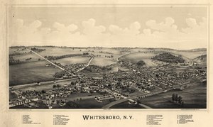
Whitesboro, N.Y. LOC 2003630341.tif - Fæ

Whitesboro, N.Y. LOC 2003630341.jpg - Fæ

Warrensburgh, N.Y. LOC 75694864.jpg - Fæ
Sanborn Fire Insurance Map from Salem, Washington County, New York. LOC sanborn06236 002.tif - Fæ

Sanborn Fire Insurance Map from Salem, Washington County, New York. LOC sanborn06236 002.jpg - Fæ
Sanborn Fire Insurance Map from Sherman, Chautauqua County, New York. LOC sanborn06262 002.tif - Fæ

Sanborn Fire Insurance Map from Sherman, Chautauqua County, New York. LOC sanborn06262 002.jpg - Fæ
Sanborn Fire Insurance Map from Belfast, Allegany County, New York. LOC sanborn05767 001.tif - Fæ

Sanborn Fire Insurance Map from Belfast, Allegany County, New York. LOC sanborn05767 001.jpg - Fæ

Gracie Emmett in her great play the Pulse of New York. LOC 75694824.jpg - Fæ
Sanborn Fire Insurance Map from Earlville, Madison And Chenango Counties, New York. LOC sanborn05890 002.tif - Fæ

Sanborn Fire Insurance Map from Earlville, Madison And Chenango Counties, New York. LOC sanborn05890 002.jpg - Fæ
Ticonderoga, N.Y. LOC 75694854.tif - Fæ

Ticonderoga, N.Y. LOC 75694854.jpg - Fæ
Marlborough, N.Y. LOC 2003630236.tif - Fæ

Marlborough, N.Y. LOC 2003630236.jpg - Fæ
Sanborn Fire Insurance Map from Hobart, Delaware County, New York. LOC sanborn05989 001.tif - Fæ

Sanborn Fire Insurance Map from Hobart, Delaware County, New York. LOC sanborn05989 001.jpg - Fæ
Oriskany Falls, N.Y. LOC 2005626659.tif - Fæ

Oriskany Falls, N.Y. LOC 2005626659.jpg - Fæ
Sanborn Fire Insurance Map from Middle Granville, Washington County, New York. LOC sanborn06079 002.tif - Fæ

Sanborn Fire Insurance Map from Middle Granville, Washington County, New York. LOC sanborn06079 002.jpg - Fæ
Sanborn Fire Insurance Map from Randolph, Cattaraugus County, New York. LOC sanborn06200 002-1.tif - Fæ

Sanborn Fire Insurance Map from Randolph, Cattaraugus County, New York. LOC sanborn06200 002-1.jpg - Fæ
Sanborn Fire Insurance Map from Randolph, Cattaraugus County, New York. LOC sanborn06200 002-2.tif - Fæ

Sanborn Fire Insurance Map from Randolph, Cattaraugus County, New York. LOC sanborn06200 002-2.jpg - Fæ
Sanborn Fire Insurance Map from Randolph, Cattaraugus County, New York. LOC sanborn06200 002-3.tif - Fæ

Sanborn Fire Insurance Map from Randolph, Cattaraugus County, New York. LOC sanborn06200 002-3.jpg - Fæ
Sanborn Fire Insurance Map from Randolph, Cattaraugus County, New York. LOC sanborn06200 002-4.tif - Fæ

Sanborn Fire Insurance Map from Randolph, Cattaraugus County, New York. LOC sanborn06200 002-4.jpg - Fæ
Sanborn Fire Insurance Map from Randolph, Cattaraugus County, New York. LOC sanborn06200 002-5.tif - Fæ

Sanborn Fire Insurance Map from Randolph, Cattaraugus County, New York. LOC sanborn06200 002-5.jpg - Fæ
Watertown, N.Y. LOC 75694867.tif - Fæ

Watertown, N.Y. LOC 75694867.jpg - Fæ

Fort Plain, N.Y. and Nelliston. LOC 75694772.jpg - Fæ

1891 Poor's Buffalo, Rochester and Pittsburg Railway.jpg - NE2