Wikimedi'Òc
Modes d'emploi

Cet album fait partie des albums
Cet album photos contient les sous-albums suivants :


The "Safety" map of Scotland - btv1b53192664h.jpg - Gzen92Bot

1892 Tourist's New Map of Scotland - Geographicus - Scotland-bartholomew-1892.jpg - BotMultichillT
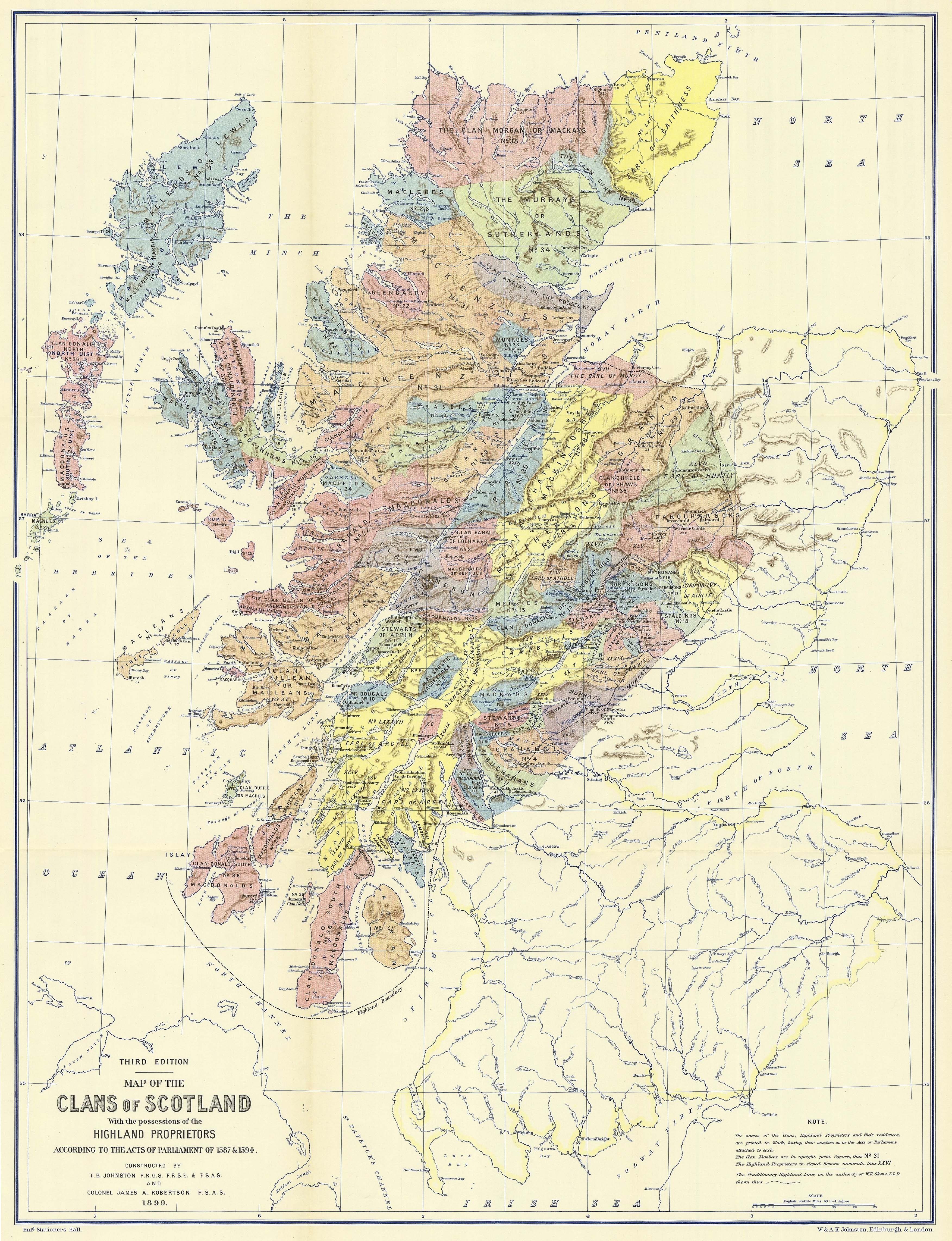
Map of the clans of Scotland (1899, third edition).jpg - Celtus~commonswiki

The story of Scotland from the earliest times to the present century (1890) (14591205507).jpg - SteinsplitterBot

The century dictionary and cyclopedia, a work of universal reference in all departments of knowledge with a new atlas of the world (1896) (14796492843).jpg - Fæ

Image taken from page 58 of 'Coloured Handbook to Kindergarten Geography, etc' (11243937823).jpg - Artix Kreiger 2

181 of 'Caledonian Railway. Tours in Scotland. (With maps.)' (11223013755).jpg - Artix Kreiger 2

56 of 'Chambers's New Geographical Readers' (11213435766).jpg - Artix Kreiger 2

76 of 'Chambers's New Geographical Readers' (11211703954).jpg - Artix Kreiger 2

116 of 'Descriptive Geography. A text-book for pupil teachers ... With ... diagrams, etc' (11213879284).jpg - FlickreviewR 2

32 of 'Chambers's New Geographical Readers' (11210023066).jpg - Artix Kreiger 2

42 of '(Longmans' Junior School Geography, etc.)' (11212890796).jpg - Artix Kreiger 2

18 of 'New Monkland Parish- its history, industries, and people ... With numerous portraits and prints from photographs' (11204135675).jpg - SteinsplitterBot

325 of 'Ordnance Gazetteer of Scotland ... New edition. Edited by F. H. Groome' (11226793984).jpg - FlickreviewR 2

15 of 'Iona' (11208313583).jpg - Artix Kreiger 2

28 of 'Outlines of Geography for the use of lower and middle forms of schools and of candidates for the Army Preliminary Examinations ... With numerous maps' (11209464393).jpg - Artix Kreiger 2

975 of 'La Terra, trattato popolare di geografia universale per G. Marinelli ed altri scienziati italiani, etc. (With illustrations and maps.)' (11245528286).jpg - Artix Kreiger 2

20 of 'Maxwell's Guide Book to the Stewartry of Kirkcudbright. Sixth edition' (11236004155).jpg - Artix Kreiger 2

21 of 'Maxwell's Guide Book to the Stewartry of Kirkcudbright. Sixth edition' (11234761234).jpg - Artix Kreiger 2

6 of 'Arnold's Geographical Handbooks' (11251642623).jpg - Artix Kreiger 2

9 of 'Arnold's Geographical Handbooks' (11249788025).jpg - Artix Kreiger 2

15 of 'Arnold's Geographical Handbooks' (11249868905).jpg - Kilom691

39 of 'Arnold's Geographical Handbooks' (11251674254).jpg - Artix Kreiger 2

175 of 'Inverkeithing. North Queensferry. Limekilns. Charlestown. The Ferry Hills. Their antiquities and recreative resources. History of Dunfermline Golf Club and plan of course. Edited by A. S. Cunningham' (11290389763).jpg - Artix Kreiger 2

16 of '(North Sea Pilot.)' (11229715903).jpg - Artix Kreiger 2

340 of '(Black's Guide to the Isle of Man.)' (11141540613).jpg - Artix Kreiger 2

197 of 'A New History of England and Great Britain ... Eleventh edition' (11145909295).jpg - Artix Kreiger 2

Image taken from page 133 of 'Scotland Picturesque and Traditional. A pilgrimage with staff and knapsack' (11302320845).jpg - Artix Kreiger 2

Image taken from page 237 of 'Scotland Picturesque and Traditional. A pilgrimage with staff and knapsack' (11136921666).jpg - Artix Kreiger 2

25 of '“Mountain, Moor and Loch” illustrated by pen and pencil, on the route of the West Highland Railway' (11227541383).jpg - Artix Kreiger 2

26 of '“Mountain, Moor and Loch” illustrated by pen and pencil, on the route of the West Highland Railway' (11226765035).jpg - Artix Kreiger 2

28 of '“Mountain, Moor and Loch” illustrated by pen and pencil, on the route of the West Highland Railway' (11304270263).jpg - Artix Kreiger 2

28 of '“Mountain, Moor and Loch” illustrated by pen and pencil, on the route of the West Highland Railway' (11305775836).jpg - Artix Kreiger 2

27 of '“Mountain, Moor and Loch” illustrated by pen and pencil, on the route of the West Highland Railway' (11230037594).jpg - Artix Kreiger 2

70 of '(Our own country. Descriptive, historical, pictorial.)' (11297712245).jpg - Artix Kreiger 2

74 of '(Our own country. Descriptive, historical, pictorial.)' (11248699543).jpg - Artix Kreiger 2

171 of '(Our own country. Descriptive, historical, pictorial.)' (11245177623).jpg - Artix Kreiger 2

167 of '(Our own country. Descriptive, historical, pictorial.)' (11291715283).jpg - Artix Kreiger 2

402 of '(Our own country. Descriptive, historical, pictorial.)' (11298556573).jpg - Artix Kreiger 2

176 of '(Our own country. Descriptive, historical, pictorial.)' (11295183036).jpg - Artix Kreiger 2

56 of '(Our own country. Descriptive, historical, pictorial.)' (11293216946).jpg - Artix Kreiger 2

217 of '(Our own country. Descriptive, historical, pictorial.)' (11294605396).jpg - Artix Kreiger 2

107 of '(Our own country. Descriptive, historical, pictorial.)' (11294054576).jpg - Artix Kreiger 2

113 of 'Pitman's Commercial Geography of the World' (11246071776).jpg - Artix Kreiger 2

61 of 'The Round World ... New edition, revised, etc' (11114936656).jpg - Artix Kreiger 2

150 of 'Landmarks of Old Stirling' (11249675315).jpg - FlickreviewR 2

159 of 'Landmarks of Old Stirling' (11251828176).jpg - Artix Kreiger 2

145 of 'Landmarks of Old Stirling' (11290450596).jpg - Artix Kreiger 2

146 of 'Landmarks of Old Stirling' (11253075904).jpg - Artix Kreiger 2

43 of 'The “Beaumont” Geography and Map Tracing Book' (11246970793).jpg - Artix Kreiger 2

47 of 'The “Beaumont” Geography and Map Tracing Book' (11246863985).jpg - Artix Kreiger 2

45 of 'The “Beaumont” Geography and Map Tracing Book' (11246966856).jpg - Artix Kreiger 2

89 of 'The “Beaumont” Geography and Map Tracing Book' (11248464774).jpg - Artix Kreiger 2

93 of 'The “Beaumont” Geography and Map Tracing Book' (11245585494).jpg - FlickreviewR 2

95 of 'The “Beaumont” Geography and Map Tracing Book' (11248119526).jpg - SteinsplitterBot

49 of 'The “Beaumont” Geography and Map Tracing Book' (11248298044).jpg - Artix Kreiger 2

91 of 'The “Beaumont” Geography and Map Tracing Book' (11245058434).jpg - Artix Kreiger 2

61 of 'How to draw and colour a Map- being a guide to the “Beaumont” series of geography and map tracing books ... Illustrated' (11246898873).jpg - FlickreviewR 2

21 of 'A Mid-Lothian Village- notes on the village and parish of Corstorphine. Compiled and illustrated by G. M. Selway, etc' (11295076635).jpg - Artix Kreiger 2

26 of '(Outlines of Geography for the use of lower and middle forms of schools and of candidates for the Army Preliminary Examinations ... With numerous maps.)' (11231482043).jpg - Artix Kreiger 2