Wikimedi'Òc
Modes d'emploi

Cet album fait partie des albums
Cet album photos contient les sous-albums suivants :


Hanoi quartier administratif petit lac map plan 1886.jpg - Arria Belli
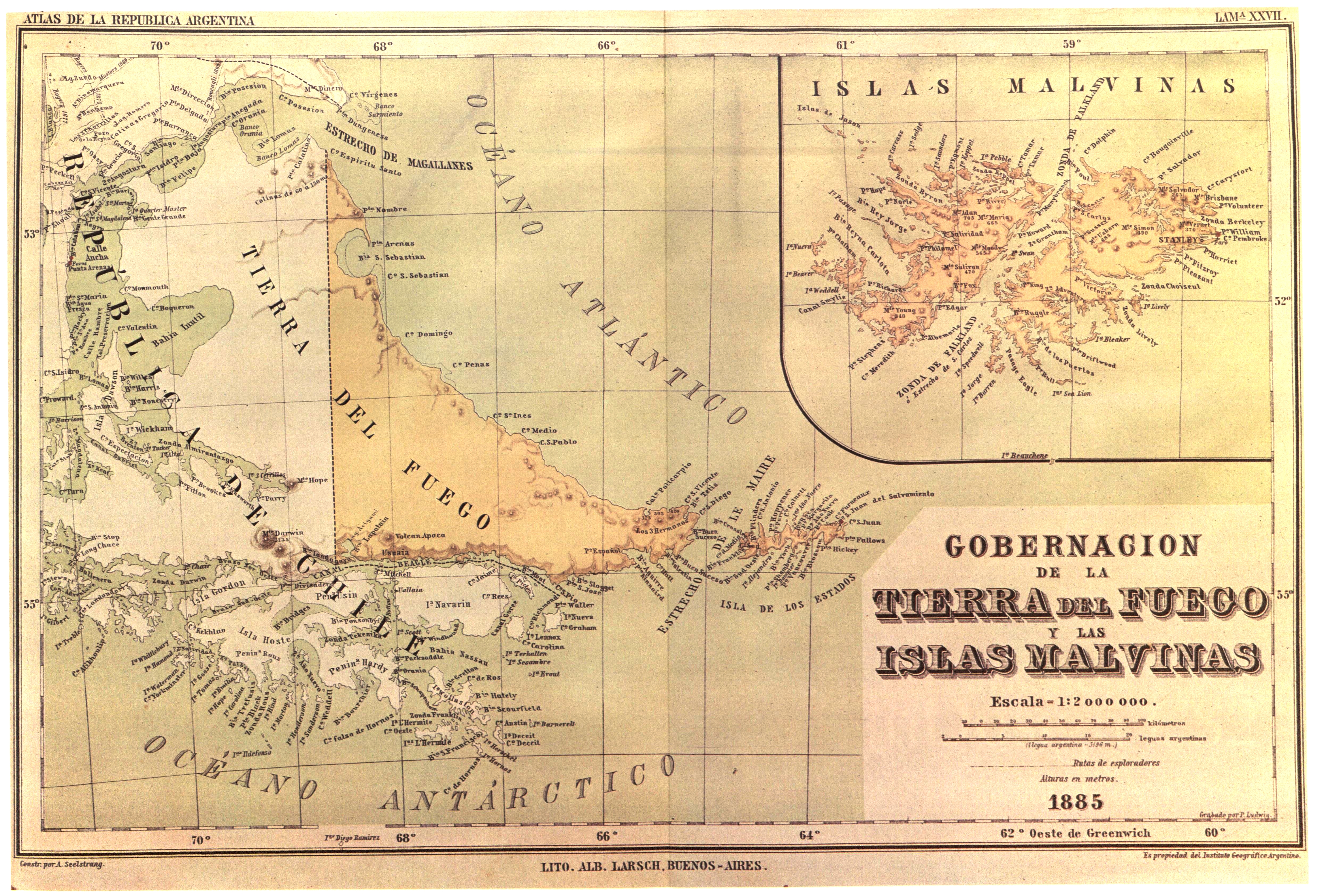
Seelstrang1886.jpg - Janitoalevic

Roumanie (1886).jpg - Alex:D

Aqua traiana planlatium.jpg - Coldeel

Marea Neagra nord-vest 1886.JPG - Alex:D

PSM V28 D454 Hallet point excavations and tunnel 7.jpg - Ineuw

PSM V28 D456 Plan of excavations of flood rock.jpg - Ineuw
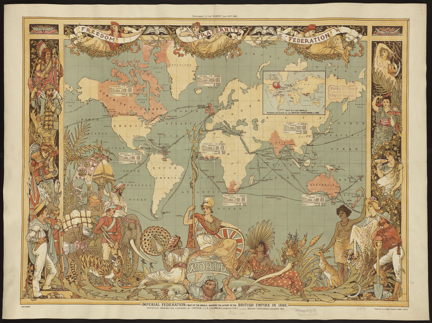
British empire 1886.jpg - Nikkimaria
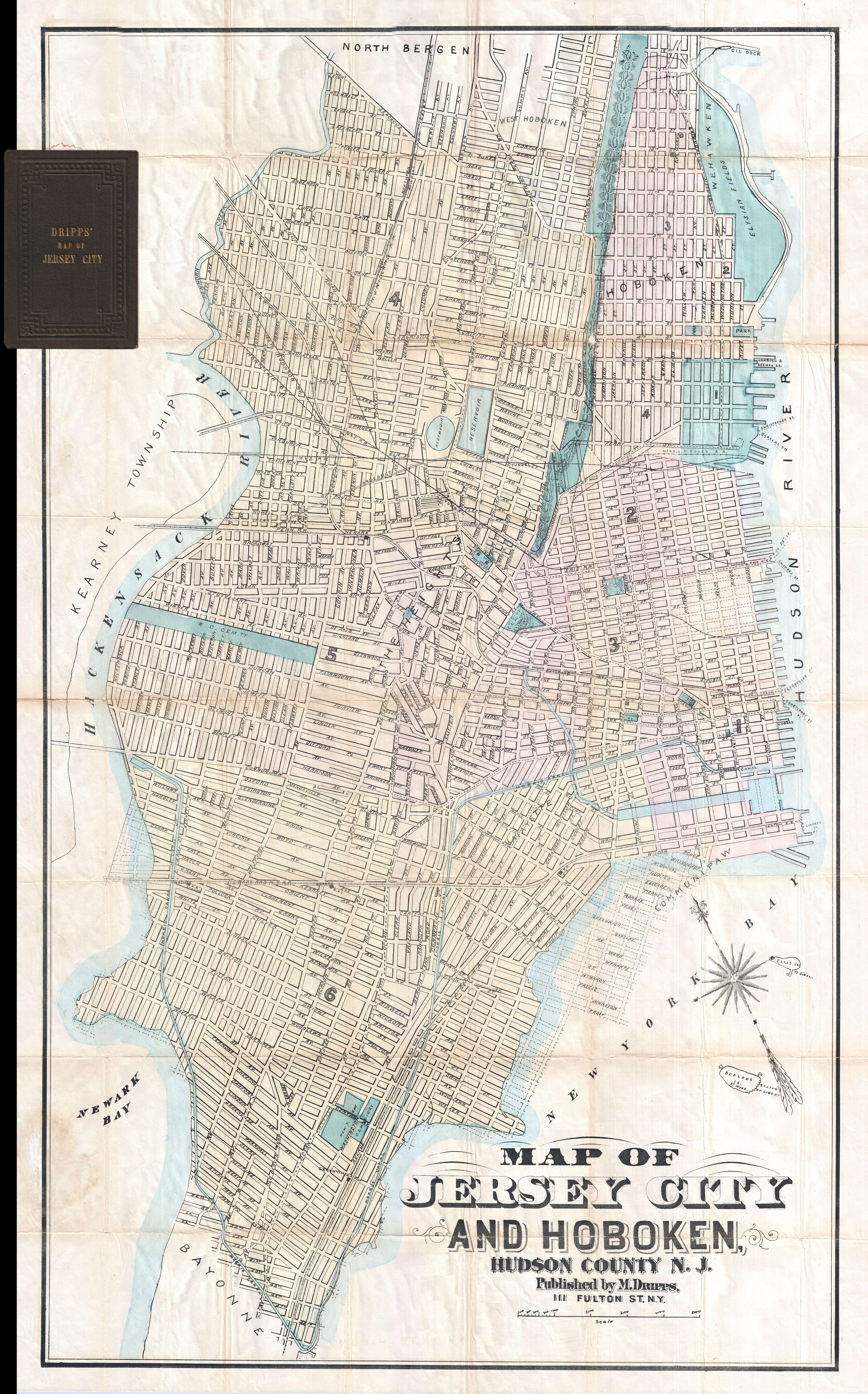
1886 Dripps Map of Hoboken and Jersey City, New Jersey - Geographicus - HobokenJerseyCity-dripps-1886.jpg - BotMultichillT

1886 Hotel and Theater Advertising Map of New York City - Geographicus - NewYork-hotelpublishing-1886.jpg - BotMultichillT

1886 Telescopic View and Map of the Moon - Geographicus - Moon-unknown-1886.jpg - BotMultichillT
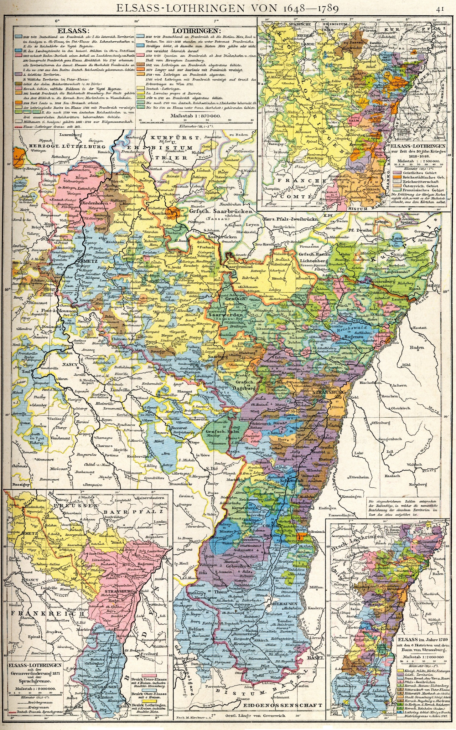
Elsass-Lothringen 1648-1789.jpg - ZH2010

Droysens-28a.jpg - Maproom

1886 SouthBoston map byBromley BPL 12259 detail.png - M2545

MapG basserman land.jpg - Happypixie

Atlanta Sanborn fire map 1886 Decatur at Pryor - Republic Block and Kimball House.JPG - Keizers
Preliminary plan for the extension of Commonwealth Avenue along Beacon Street Brookline (3370527852).jpg - File Upload Bot (Magnus Manske)

British Empire map - The India and Colonial Exhibition, London (1886) - BL.jpg - Jheald

Venice WDL411.png - Fæ
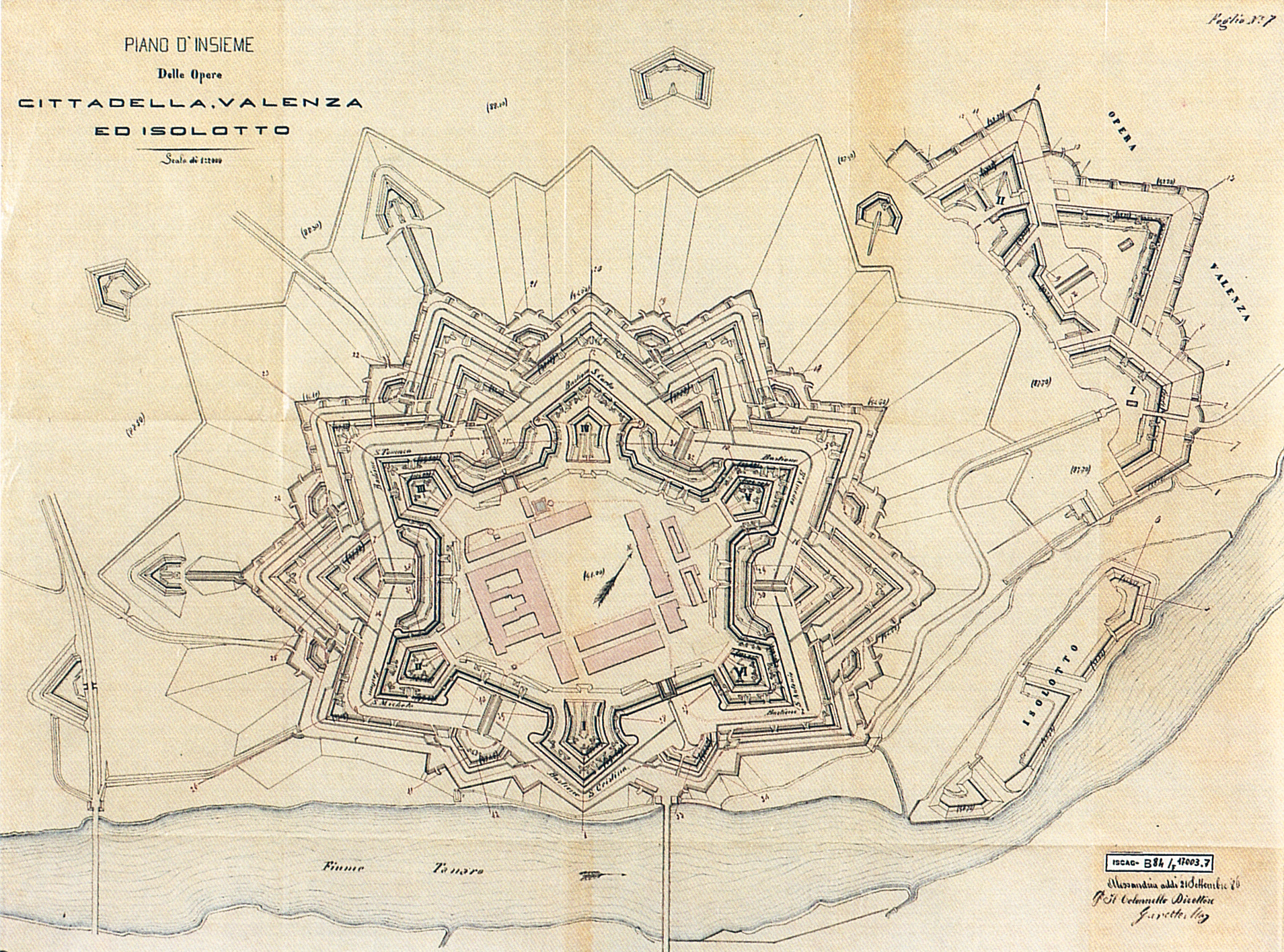
Piano di insieme.jpg - Brigante mandrogno

EB9 St Paul.jpg - Library Guy

EB9 Saratoga Springs.jpg - Library Guy

N.N.(1886) p103 Pola in der Römerzeit.jpg - Metilsteiner

N.N.(1886) p107 Pola, Stadtplan.jpg - Metilsteiner

SARMATICUS(1886) p078 BERESINA UND OBERER DNJEPR - (Skizze 8).jpg - Metilsteiner

PSM V28 D451 Hell gate new york.jpg - IneuwPublic

Annual report of the Bureau of Ethnology to the Secretary of the Smithsonian Institution (1886) (18741438153).jpg - Fæ

Annual report of the Bureau of Ethnology to the Secretary of the Smithsonian Institution (1886) (18741419123).jpg - Fæ

Anales de la Sociedad Espala de Historia Natural (1886) (17543540604).jpg - SteinsplitterBot

The American journal of science (1886) (17529928293).jpg - SteinsplitterBot
Sierck-1661.png - Anael Hagner
Bulletin (1886) (20232450568).jpg - Fæ

Colonial and Indian Exhibition, 1886 (microform) - official catalogue (1886) (20606423972).jpg - Fæ

Colonial and Indian Exhibition, 1886 (microform) - official catalogue (1886) (20622097881).jpg - Fæ

Colonial and Indian Exhibition, 1886 (microform) - official catalogue (1886) (20589227886).jpg - Fæ

EB9 Scarborough - plan.jpg - Library Guy

Rail line map of the Los Angeles and San Gabriel Valley Railroad.jpg - OgreBot
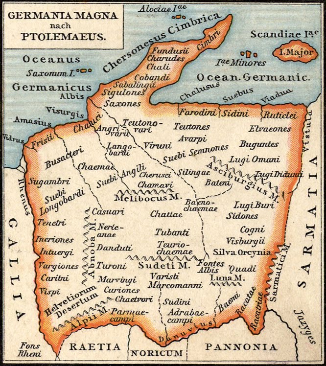
Germania Magna nach Ptolemaeus.jpg - LlywelynII
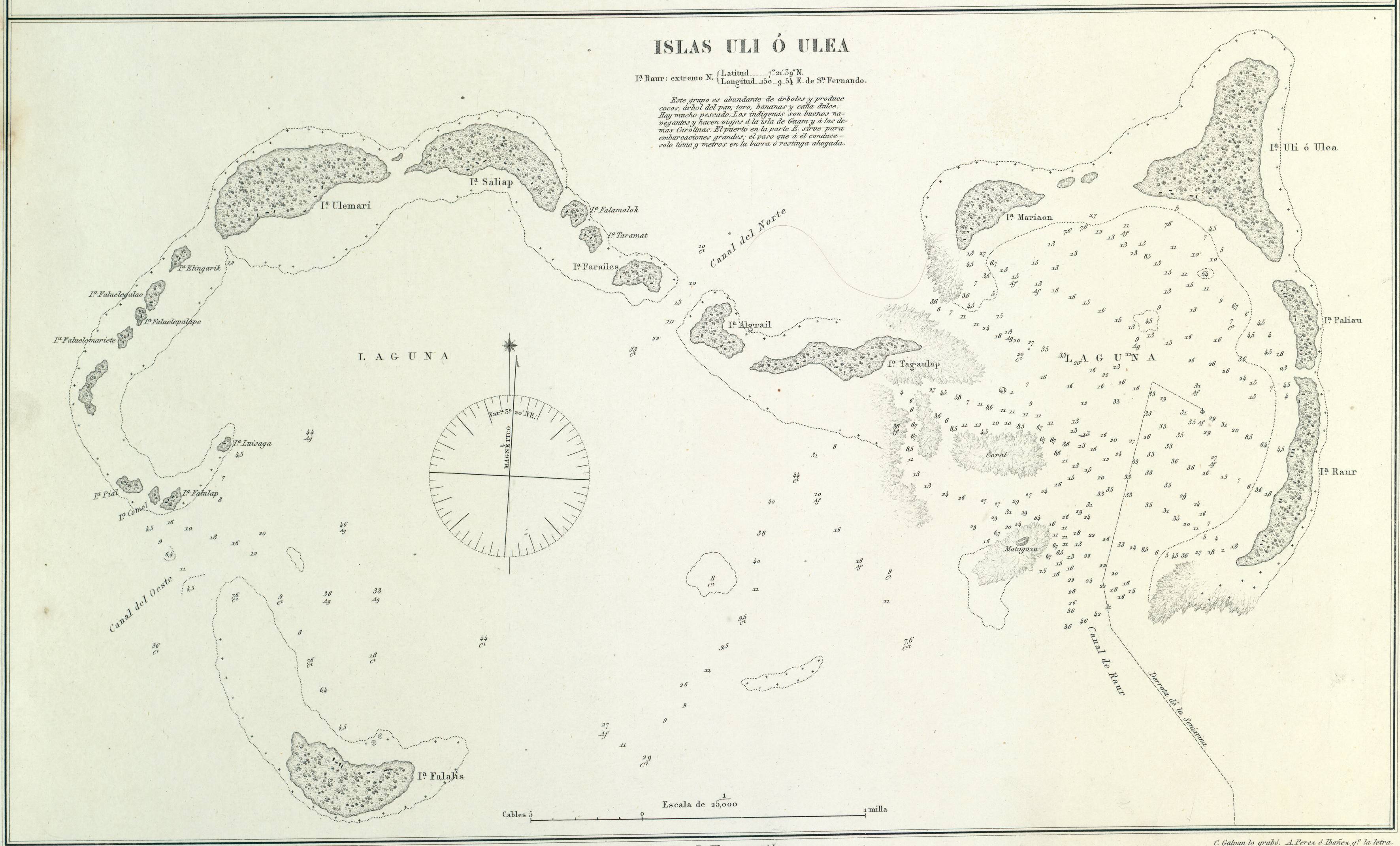
1886 Spanish nautical map of Federated States of Micronesia islands.jpg - Skimel

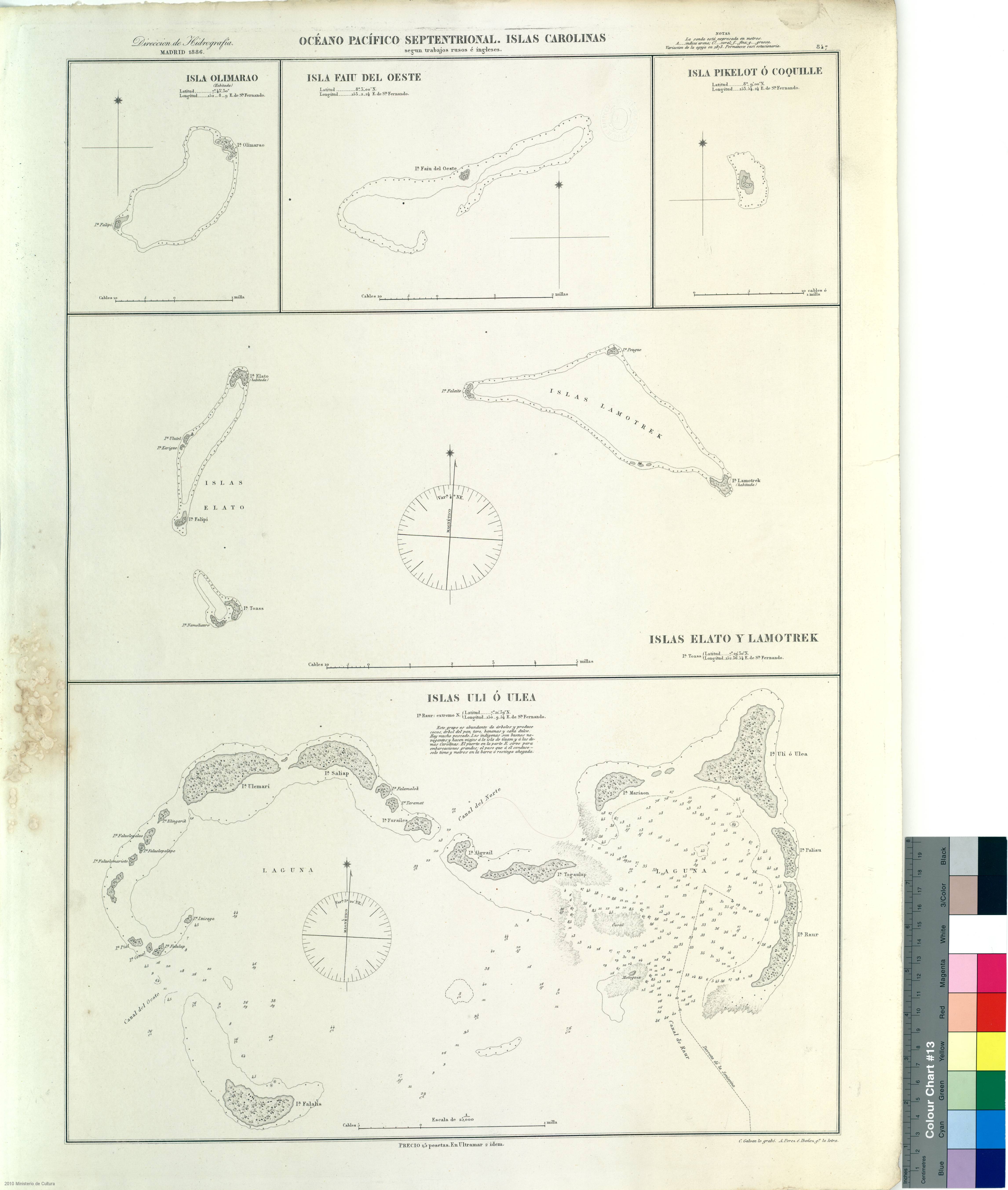
Isla Pikelot o Coquille (1886).jpg - Skimel
Volage RMG PW8166.tiff - Fæ

78 of 'Notes on the Geology of the Hull, Barnsley, & West Riding Junction Railway and Dock' (11183229845).jpg - Artix Kreiger 2

515 of 'Statistika łužiskich Serbow ... w lětach 1880-1885. Z přidawkom nadrobneje kharty serbskich Hornich a Delnich Łužic z lěta 1886' (11169784503).jpg - Artix Kreiger 2
1886 Spanish nautical map of Woleai Atoll.jpg - Ratzer

1886 Spanish nautical map of Elato and Lamotrek.jpg - Ratzer

1886 Spanish nautical map of Olimarao.jpg - Ratzer
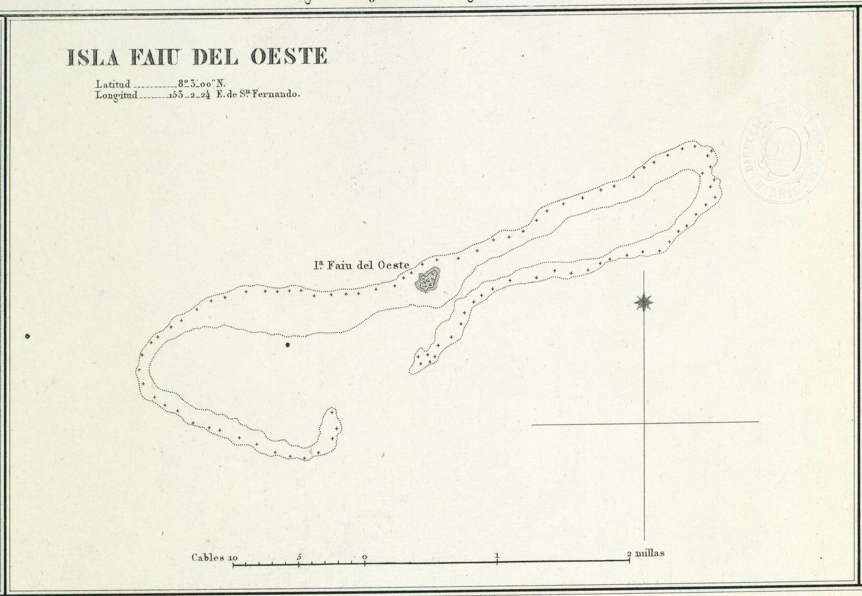
1886 Spanish nautical map of West Fayu.jpg - Ratzer

1886 Spanish nautical map of Pikelot.jpg - Ratzer
Denver and Rio Grande Railway System, 1886. LOC 98688651.tif - Fæ

Denver and Rio Grande Railway System, 1886. LOC 98688651.jpg - Fæ
General Buell's map of the battle-field of Shiloh. (April 6-7, 1862) LOC 99448855.tif - Fæ

General Buell's map of the battle-field of Shiloh. (April 6-7, 1862) LOC 99448855.jpg - Fæ

Keijō yori Genzanshin ni itaru rojōzu LOC 2008486377.jpg - Fæ
Sanborn Fire Insurance Map from Jamestown, Mercer County, Pennsylvania. LOC sanborn07735 001.tif - Fæ
Anpen-fu yori Keijō ni itaru rojōzu LOC 2008486378.tif - Fæ

Anpen-fu yori Keijō ni itaru rojōzu LOC 2008486378.jpg - Fæ
Sanborn Fire Insurance Map from Ocala, Marion County, Florida. LOC sanborn01319 002.tif - Fæ

Sanborn Fire Insurance Map from Ocala, Marion County, Florida. LOC sanborn01319 002.jpg - Fæ
Sanborn Fire Insurance Map from Le Roy, Mower County, Minnesota. LOC sanborn04326 001.tif - Fæ

Sanborn Fire Insurance Map from Le Roy, Mower County, Minnesota. LOC sanborn04326 001.jpg - Fæ

Map of the city of San Jose LOC 2012593206.jpg - Fæ
Colton's Delaware, Maryland, Virginia and West Virginia. LOC gm69002312.tif - Fæ

Colton's Delaware, Maryland, Virginia and West Virginia. LOC gm69002312.jpg - Fæ

Official railroad map of Dakota issued by the railroad commissioners, November 1st, 1886. LOC 98688534.jpg - Fæ
Sanborn Fire Insurance Map from Portland, Traill County, North Dakota. LOC sanborn06563 001.tif - Fæ

Sanborn Fire Insurance Map from Portland, Traill County, North Dakota. LOC sanborn06563 001.jpg - Fæ
Sanborn Fire Insurance Map from Sheldon, Ransom County, North Dakota. LOC sanborn06567 001.tif - Fæ

Sanborn Fire Insurance Map from Sheldon, Ransom County, North Dakota. LOC sanborn06567 001.jpg - Fæ
Maryland-District of Columbia-Virginia, Washington sheet LOC 94684037.tif - Fæ

Maryland-District of Columbia-Virginia, Washington sheet LOC 94684037.jpg - Fæ
Map of survey of Whitney Close, divided into squares 1 to 11 inclusive, in the county of Washington, District of Columbia - recorded in book "County no. 6," pages 62, 63, Surveyor's Office D.C., Dec. LOC 88693246.tif - Fæ

Map of survey of Whitney Close, divided into squares 1 to 11 inclusive, in the county of Washington, District of Columbia - recorded in book "County no. 6," pages 62, 63, Surveyor's Office D.C., Dec. LOC 88693246.jpg - Fæ
The Am. Manufacturer's map of the New River & the Flat-top coking coal fields of the Virginias LOC 2005625151.tif - Fæ

The Am. Manufacturer's map of the New River & the Flat-top coking coal fields of the Virginias LOC 2005625151.jpg - Fæ
Kyzer's complete map of Cleveland County, N.C. - 1886 LOC 2012593701.tif - Fæ

Kyzer's complete map of Cleveland County, N.C. - 1886 LOC 2012593701.jpg - Fæ
Map of Great Kanawha coal field showing location of mines. LOC 00556411.tif - Fæ

Map of Great Kanawha coal field showing location of mines. LOC 00556411.jpg - Fæ
Sierre LOC 2007632857.tif - Fæ

Sierre LOC 2007632857.jpg - Fæ
Röthenbach LOC 2008621300.tif - Fæ

Röthenbach LOC 2008621300.jpg - Fæ
Sanborn Fire Insurance Map from Tuscarora, Elko County, Nevada. LOC sanborn05297 001.tif - Fæ

Sanborn Fire Insurance Map from Tuscarora, Elko County, Nevada. LOC sanborn05297 001.jpg - Fæ
Map of Brown County, Minn. - from personal examination and public records. LOC 2012593032.tif - Fæ

Map of Brown County, Minn. - from personal examination and public records. LOC 2012593032.jpg - Fæ

Map of Catawba County, North Carolina. LOC 2001620490.jpg - Fæ
Sanborn Fire Insurance Map from Muskogee, Muskogee County, Oklahoma. LOC sanborn07189 001.tif - Fæ

Sanborn Fire Insurance Map from Muskogee, Muskogee County, Oklahoma. LOC sanborn07189 001.jpg - Fæ

Sanborn Fire Insurance Map from Vinita, Craig County, Oklahoma. LOC sanborn07285 001.jpg - Fæ
Sanborn Fire Insurance Map from McAlester, Pittsburg County, Oklahoma. LOC sanborn07162 001.tif - Fæ

Sanborn Fire Insurance Map from McAlester, Pittsburg County, Oklahoma. LOC sanborn07162 001.jpg - Fæ
1886 map - Atlas des ports étrangers.pdf - Balkanique

Section de Tsong-Ming, 1885-86 - Mission de Nanking - btv1b53070043c.jpg - Gzen92Bot

George Armstrong, Map of the Wady el Arabah from the surveys of Major Kitchener, R.E. and reduced from the 3-8 inch map (FL33249947 2367933).jpg - Geagea

Henri Nicole, Plan topographique de Jerusalem et de ses environs (FL6880591 2368140).jpg - Geagea

Palestine in the time of our saviour (FL35098638 3892362).jpg - Geagea

Gottlieb Schumacher, Map of Western Hauran & Eastern Jaulan (part of) from the survey of Gottlieb Schumacher, C.E (FL45611999 3954731).jpg - Geagea

Flammarion - La planète Mars, Tome 2-f024.jpg - F0x1

Davison's Pocket Map of Minneapolis - DPLA - 12175ef5b5b40be9558d96488480b6b0.jpg - DPLA bot

Alsace-Lorraine 1648-1789 (134037804).jpg - Redaktor GLAM